
LoZompatore’s Evergrun, 72 miles per hex
GAZ5’s map showed a label for Evergrun, but only next to an arrow pointing to the edge of the map. The Italian community took this idea and ran with it, developing it as an island off the coast of Davania. Michele was the first to mark it on a map, in his Precataclysmic Mystara series in 2005, but he only marked the general location, not the shape of the island. Simone Neri added that detail in his 2008 map showing the history of Rakastas.
It wasn’t until 2013 and the map below that Michele produced a full hex map of the island and its neighbouring area of Davania. He set the location with reference to his own map, while adapting the shape of the island from Simone’s map. Then he added a great deal of detail, including myriad smaller islands. There’s even a small inset map with a polar view to show the location on the globe.
The place names appearing on the map all stem from modern and historical elven clans appearing across Mystara’s published works.
Michele provided a write-up of Evergrun to go with the map, which you can see at the Vaults of Pandius.
All in all, this is a prime example of the sort of projects Michele has continued to publish over the years. His visuals seem to get better and better with every project, but the quality of research and presentation has otherwise been a constant from the beginning of his work on Mystara.
Fan-made Map by Michele Carpita (August 2013)
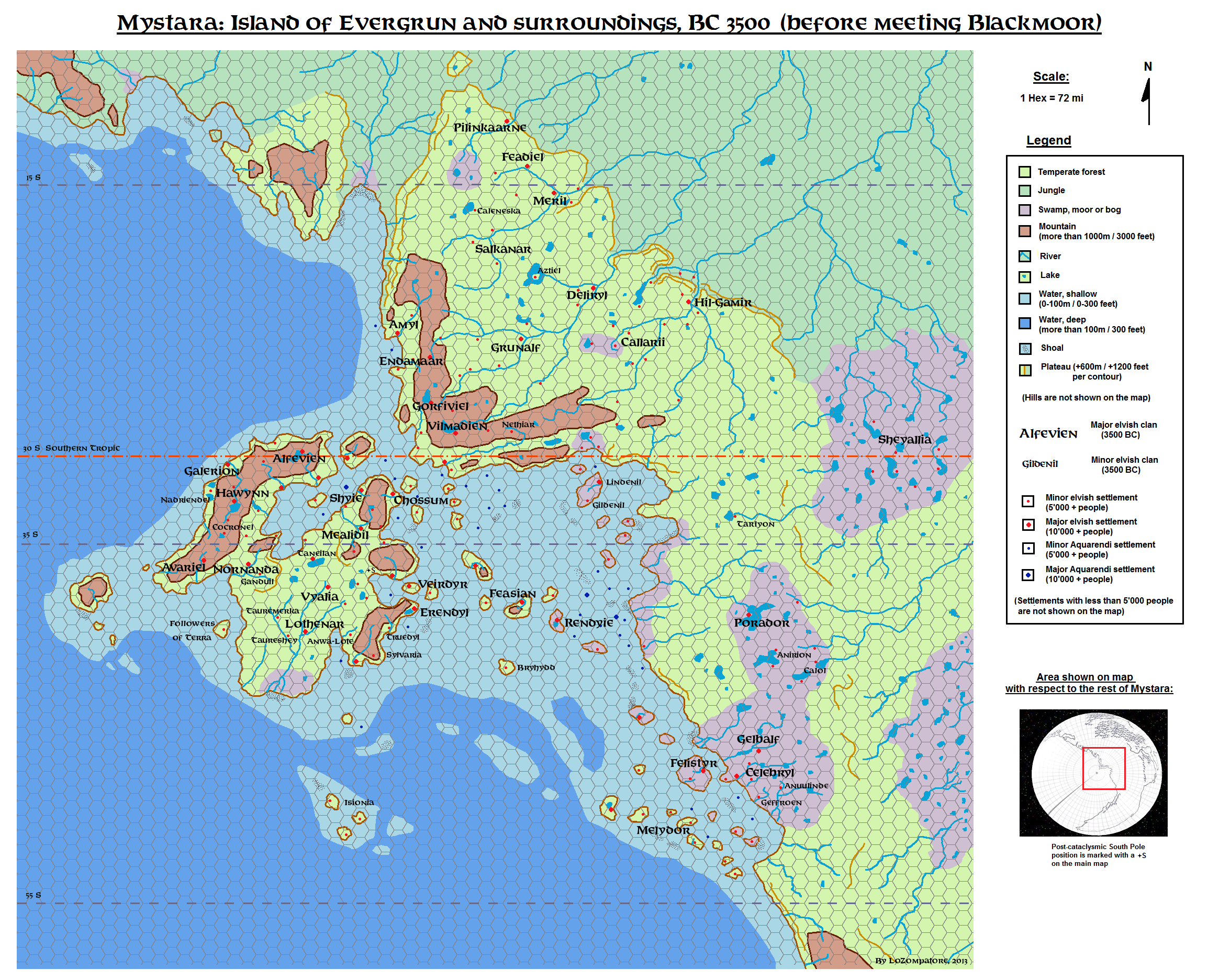
This is an original map created by one of Mystara’s excellent fan cartographers. For more information on the cartographer, including a gallery of all their maps, see also Appendix M: Mappers of Mystara.
Sources
- GAZ5 The Elves of Alfheim (1988) (PDF at DriveThruRPG)
Fan Sources
- History And Evolution of Rakastas by Simone Neri at the Vaults of Pandius (August 2008)
- A map of Evergrun and the elvish colonies, BC3500 discussion thread at The Piazza (August 2013)
- A map of Evergrun and the elvish colonies, BC3500 by Michele Carpita at the Vaults of Pandius (August 2013)
References
- All of Michele’s maps at the Atlas of Mystara
- Michele’s entry in Appendix M: Mappers of Mystara (upcoming)
- Michele’s author page at the Vaults of Pandius
Chronological Analysis
This is a fan-made map. It was published in August 2013. The updated Atlas version of this map is not yet available. See also Appendix C for annual chronological snapshots of the area. For the full context of this map in Mystara’s publication history, see the upcoming Let’s Map Mystara 2013.
The following lists are from the Let’s Map Mystara project. Additions are new features, introduced in this map. Revisions are changes to previously-introduced features. Hex Art & Fonts track design elements. Finally, Textual Additions are potential features found in the related text. In most cases, the Atlas adopts these textual additions into updated and chronological maps.
Under Construction! Please check back again soon for updates.
Additions
- XXX —
Revisions
- XXX —
Hex Art & Fonts
- Hex Art —
- Fonts —
")
")
")