
M5 Lands of the Aranea, 3 miles per hex
A detail map of the area above the canyon of the Aurora River, on the Isle of Dawn’s Great Escarpment.
Replica Map (May 2021)
Sources
- M5 Talons of Night (1987) (PDF at DriveThruRPG)
- Page 26 map (Cartography by Dennis Kauth, Steve Sullivan)
Chronological Analysis
This is Map 72. It was published in November 1987. The updated version of this map has not yet been released. See also Appendix C for annual chronological snapshots of the area. For the full context of this map in Mystara’s publication history, see Let’s Map Mystara 1987.
The following lists are from the Let’s Map Mystara project. Additions are new features, introduced in this map. Revisions are changes to previously-introduced features. Hex Art & Fonts track design elements. Finally, Textual Additions are potential features found in the related text. In most cases, the Atlas adopts these textual additions into updated and chronological maps.
Under Construction! Please check back again soon for updates.
Additions
- Rivers —
Revisions
- Settlements —
Hex Art & Fonts
- Symbols — Hand-drawn symbols.
- Fonts — Helvetica throughout.
Textual Additions (M5, November 1987)
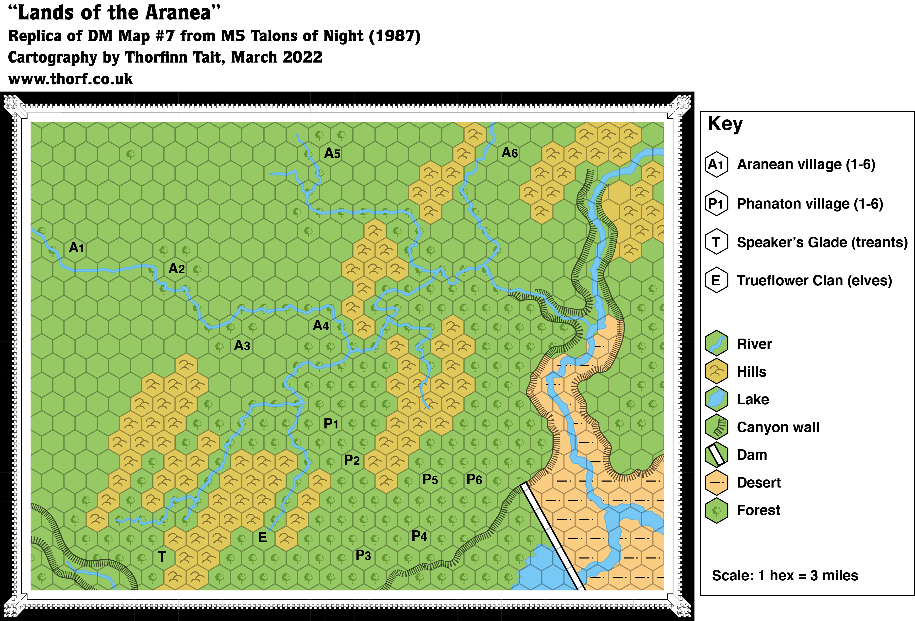
- Rivers — This map features three named rivers and numerous small tributaries. According to the Valley of the Kings map, the large river in the southeast corner is the Aurora River, while the smaller but still rather large river flowing into it is the Spider River. So far, so good. What is not so clear is which of the rivers upstream of the fork is the Spider River. Going by the map, we would expect the larger river that continues north and then east off the edge of the map to be the Spider River. However, M5 page 31a splits encounters in this area into those “South of the Spider River” and “North of the river”, with fewer encounters in the south. This suggests that the Spider River is in fact the river flowing from the west past A1. If that is the case, then the other named river, the Red Sabre River (M5 page 20a), must be the wider river shown flowing north and then west off the map. To sum up:
- The Spider River flows onto the map from the west, passing location A1 and flowing due east. After location A4, it is joined by four other rivers in succession before cascading over the Spider Falls into a side canyon of Spider Canyon. It then flows gradually down through the canyon, with the Red Sabre River meeting it as it enters the main canyon. Finally it flows southwards into the Valley of the Kings, where it joins the mighty Aurora River.
- The Red Sabre River begins just off the eastern edge of the map (going by the Valley of the Kings map), then turns south and enters the Spider Canyon at its far end through Garsh Falls. It then flows south to join with the Spider River halfway down the canyon.
- Rulers — Minor rulers for this area are mentioned:
- King Choppadigga of the Phanatons above Spider Canyon. (M5 page 30b)
- Elmbeard Longleavesrustlinginthewindatdusk, shaman of the treants above Spider Canyon. (M5 page 30b)
- Clanmaster Trueflower of the Trueflower elves. (M5 page 30b)
- Settlements — The map marks a total of fourteen settlements, denoted in the key. None are given actual names. The text provides some details:
- Phanaton Villages: These villages are “built upon platforms about 50 feet above the forest floor. Although the phanaton can glide from platform to platform, the platforms are connected by rope ladders and bridges. Simple huts on the platforms house family and craft groups. Each village has about 200 occupants.” (M5 page 29a)
- Trueflower Clan: This clan of elves has a “stronghold”, presumably a village of some sort. (M5 page 30bc)
- Speaker’s Glade: This location marked on the map is the “stronghold” of the treants. It’s unclear from the text what form it may take. (M5 page 20bc)
- Waterfalls — Although the map clearly shows rivers flowing gradually down through deepening canyons until they meet the Aurora River, the text suggests a slightly different picture: “Following the Spider River upstream, they encounter either Spider Falls on the Spider, or Garsh Falls on the Red Sabre River. Both falls are impassable”. It goes on, “The walls of Spider Canyon near the falls are 600 feet high, but near the entrance to the Valley of Kings, they are a daunting 2,000 feet”. (All M5 page 20a) This suggests that the gradually sloping canyons are just as shown, but that each canyon ends in a waterfall. For the discussion of which river is which, see Rivers.


