
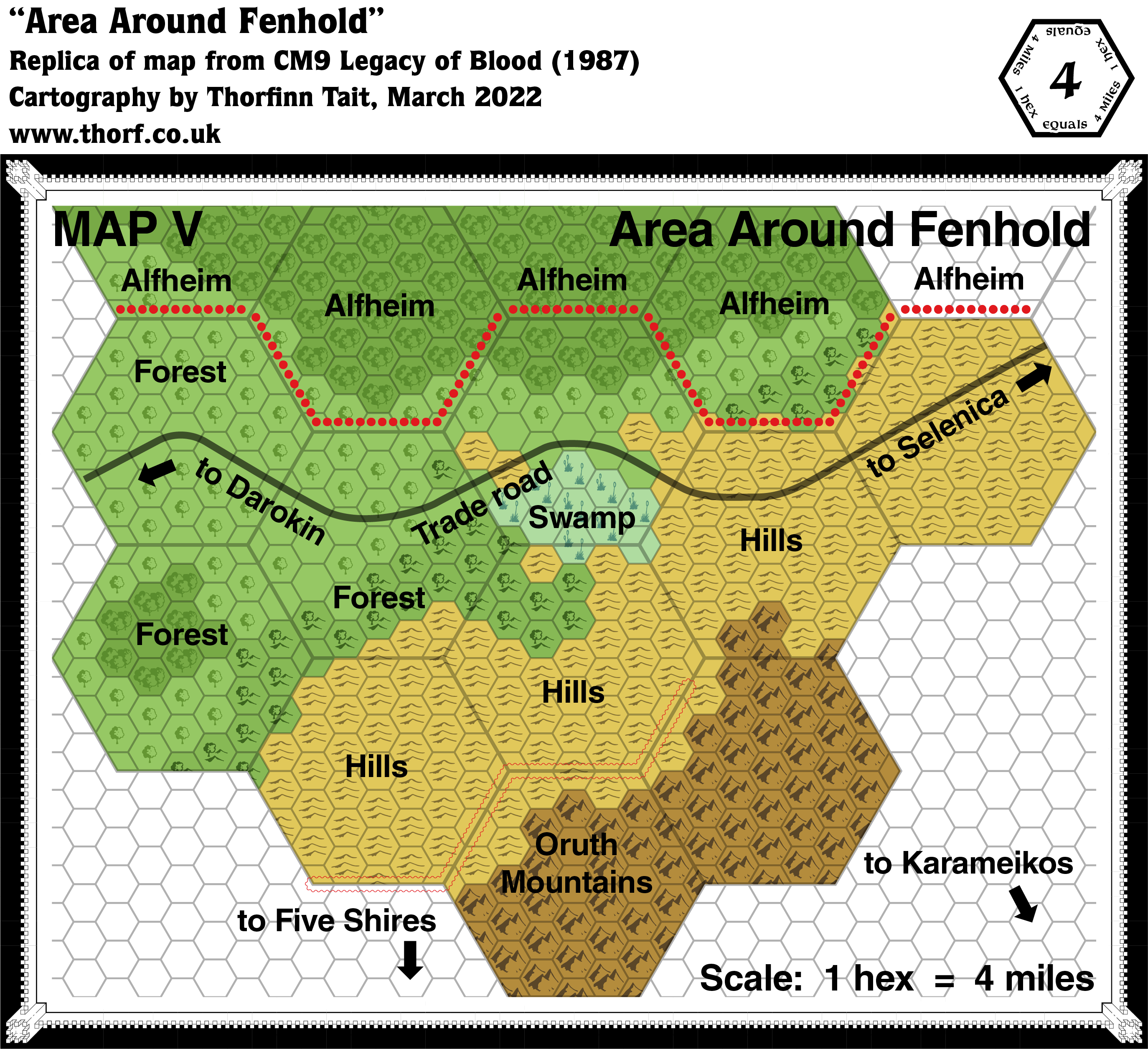
CM9 Fenhold Area, 4 miles per hex
The last of the Companion-level modules, CM9 was published concurrent with the Gazetteer series. It included some very close-up details of a Darokin dominion. This map placed Fenhold along the Darokin-Selenica road, next to the Alfheim border.
Replica Map (March 2022)
Sources
- CM9 Legacy of Blood (1987) (PDF at DriveThruRPG)
- Page 5 map (Cartography by Stephanie Tabat, Sue Myers, Gloria Habriga, and Dave Sutherland)
Chronological Analysis
This is Map 70. It was published in September 1987. The updated version of this map has not yet been released. See also Appendix C for annual chronological snapshots of the area. For the full context of this map in Mystara’s publication history, see Let’s Map Mystara 1987.
The following lists are from the Let’s Map Mystara project. Additions are new features, introduced in this map. Revisions are changes to previously-introduced features. Hex Art & Fonts track design elements. Finally, Textual Additions are potential features found in the related text. In most cases, the Atlas adopts these textual additions into updated and chronological maps.
Under Construction! Please check back again soon for updates.
Additions
- Terrain —
Revisions
- Spelling — The Cruth Mountains are misspelled “Oruth Mountains”.
Hex Art & Fonts
- Symbols — Gazetteer standard.
- Fonts — Helvetica throughout.
Textual Additions (CM9, September 1987)
- Settlements —
")


21 March 2022 @ 3:55 am
typo? Oruth mtns
21 March 2022 @ 10:23 pm
It is indeed a typo, but not mine — that’s what the original map says.
5 May 2022 @ 2:15 am
So, the page is in “3 miles per hex”, the map hexes are “4 miles”. Is it a wonder that we don’t actually know what hexes are that size?
(Cruth Mountains)
5 May 2022 @ 11:09 am
Did you perhaps post this comment to the wrong map? This one has no particular scale problems: it’s marked 4 miles per hex, and that is indeed what it is. The larger hexes are 24 mile hexes.
However, in fact this map is highly problematic, as its terrain doesn’t match anywhere on the 24 mile per hex map. It’s very frustrating!
5 May 2022 @ 4:54 pm
I don’t know. Does the one you’re commenting on say “CM9 Fenhold Area, 3 miles per hex …”? Does it show large landscape sized hexes, most of which have individual descriptions and a description saying that 1 hex is 4 miles? Yet, underneath that is a damasc of smaller hexes, mostly matching the full sized ones, but continuing as blank hexes further out? That’s the one I am commenting on, and the two sizes obviously don’t match the two scales. Also, I am sure the obvious scales are obvious to those to whom they are obvious, but they are marked for those to whom the scales are not obvious. To those, the map has two hex sizes and one marking (apart from the 3 miles one). So, no: Its hexes are not marked 4 miles: one set of hexes is marked thus, but that doesn’t tell the whole story.
Also, not yet sure where this is supposed to be, but that may yet depend on its scale.
5 May 2022 @ 6:15 pm
It took me quite a long time to discover where you were reading “3 miles per hex”. Now I see that I originally made a typo when I posted the map, and although I quickly fixed it, I overlooked one instance. Sorry about that. It should be fixed now.
In short, it was never 3 miles per hex. That was just a typo.
As to it being 4 miles per hex, the map itself clearly states this in the bottom right corner. My own scale mark in the top right replicates this.
Yes, there are two hex sizes on the map. This was not an uncommon practice at the time, and it’s not nearly as confusing as you might think if you view the map in the context of its time, when showing an overlay of the 24 mile hexes of the original X1 Known World map was a reasonably common practice.
In any case, the smaller hexes are clearly the main grid, as the terrain hexes fit into them. The larger hexes are just an overlay. People familiar with the Known World back in 1987 would have had no trouble spotting this. Besides, six 4 mile hexes obviously add up to one 24 mile hex. You are correct that the scale of the larger hexes is not explicitly marked.
Finally, this is a replica. All I’m doing here is reproducing the original map from 1987, complete with all its weirdness and errors. I will take all of your comments into consideration when I make the updated version, but as I mentioned, in fact the terrain shown is the biggest problem of all. The location is the southern edge of Alfheim, but the precise location is not at all clear due to the terrain mismatching.