GAZ9’s trading map included a set of symbols to illustrate economic maps of the world, showing the imports and exports of each major settlement. The legend was fairly comprehensive, although it was slightly expanded upon the next year in GAZ11.
I have expanded the legend of the map to show the symbols in the colours used for imports and exports, and rearranged it across multiple columns. Otherwise, it appears as it did on the original map.
Following on from GAZ9’s map of shipping routes, GAZ11 The Republic of Darokin mapped out the land routes of the Known World. Together the two maps provide a comprehensive economic overview of the area.
Since GAZ11’s map was printed inside the book, the Atlas provides two versions of the replica map: one with the original colour scheme, and another that uses GAZ9’s full colour palette.
The Minrothad Guilds gazetteer introduced a trading system, complete with supply and demand mechanics and this beautiful map of major trading routes. The open and accessible style brought a refreshing new clarity to the familiar Known World region, while the iconography provided rich economic information.
The style was later revisited in GAZ11 The Republic of Darokin, which applied the same style to expand the map inland.
Much later, fans created further additions, expanding the area of coverage in both text and cartographic form.
Replica Map (May 2018)
Replica of GAZ9’s Major Known Trading Routes poster map
Bertrand Lhoyez created this map in 2003 to expand the Major Trading Routes maps from GAZ9 and GAZ11 to the west. It adds economic details for all the major settlements of Sind, the Great Waste, and the Serpent Peninsula, while also featuring the edges of Hule and the tip of Davania. Basically, it covers everything from Champions of Mystara’s two poster maps.
It’s all rather well done, with all the major elements from the official trade maps in place: import/export panels, trails and roads complete with distances — even the art style is similar.
Fan-made Map by Bertrand Lhoyez (June 2003)
Serpent Peninsula Trade Map by Bertrand Lhoyez, June 2003
This is an original map created by one of Mystara’s excellent fan cartographers. For more information on the cartographer, including a gallery of all their maps, see also Appendix M: Mappers of Mystara.
The original map of the Savage Coast, updated from the 1985 version to incorporate Dungeon 6-7’s Great Northway Lands, with everything in Gazetteer-style hex art and fonts. The main additions were to the river systems in the northwest of the map, from the Shady River northwards, as well as the Richland Trading Post.
Nothing more would happen with this region for the next few years, until Bruce Heard started to explore it in great detail in his Voyage of the Princess Ark series in mid-1991.
This map is part of the Mystara 1987 series of chronological maps. It is an updated map, incorporating all available sources and made internally consistent with other maps in its series. But it only uses sources published in or before 1987.
This cold, dark land […] faces the chilly waters where the Sea of Dawn meets the Alphatian Sea. In winter, piercingly cold winds blow down from Norwold. This is a harsh, hard land, a land where crops struggle to take hold in thin and rocky soil, a land where livestock which survives the harsh winters is thin, stringy, and mean. But it is, to many eyes, a beautiful land. Inland, the land is dominated by tall, hard-edged mountains; toward the sea, the arable lowlands look more welcoming than they actually are; everywhere, pine forests grow tall, deep, and dark.
from Poor Wizard’s Almanac, by Aaron Allston
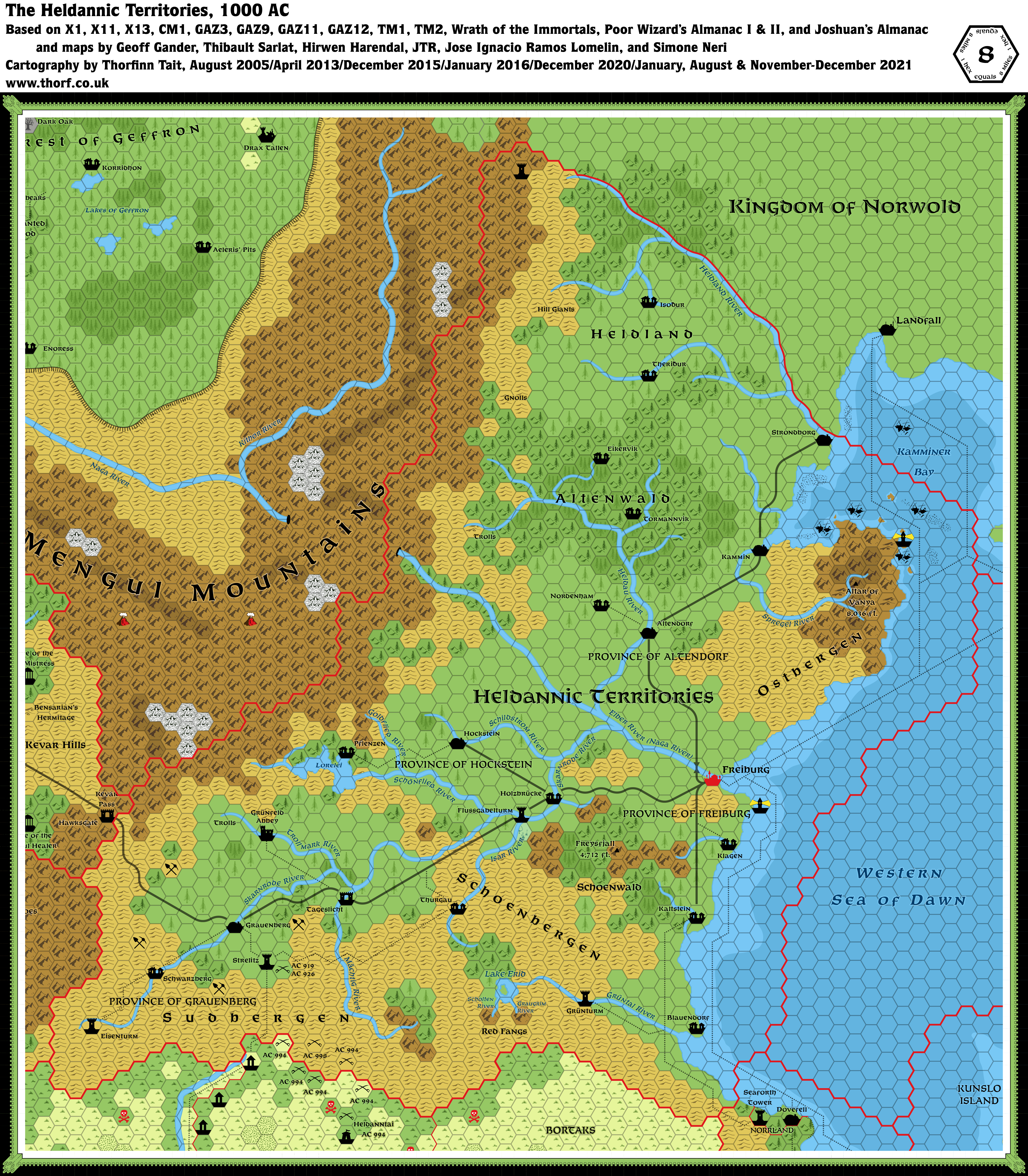
Map (December 2021)
Updated map of the Heldannic Territories, 8 miles per hex
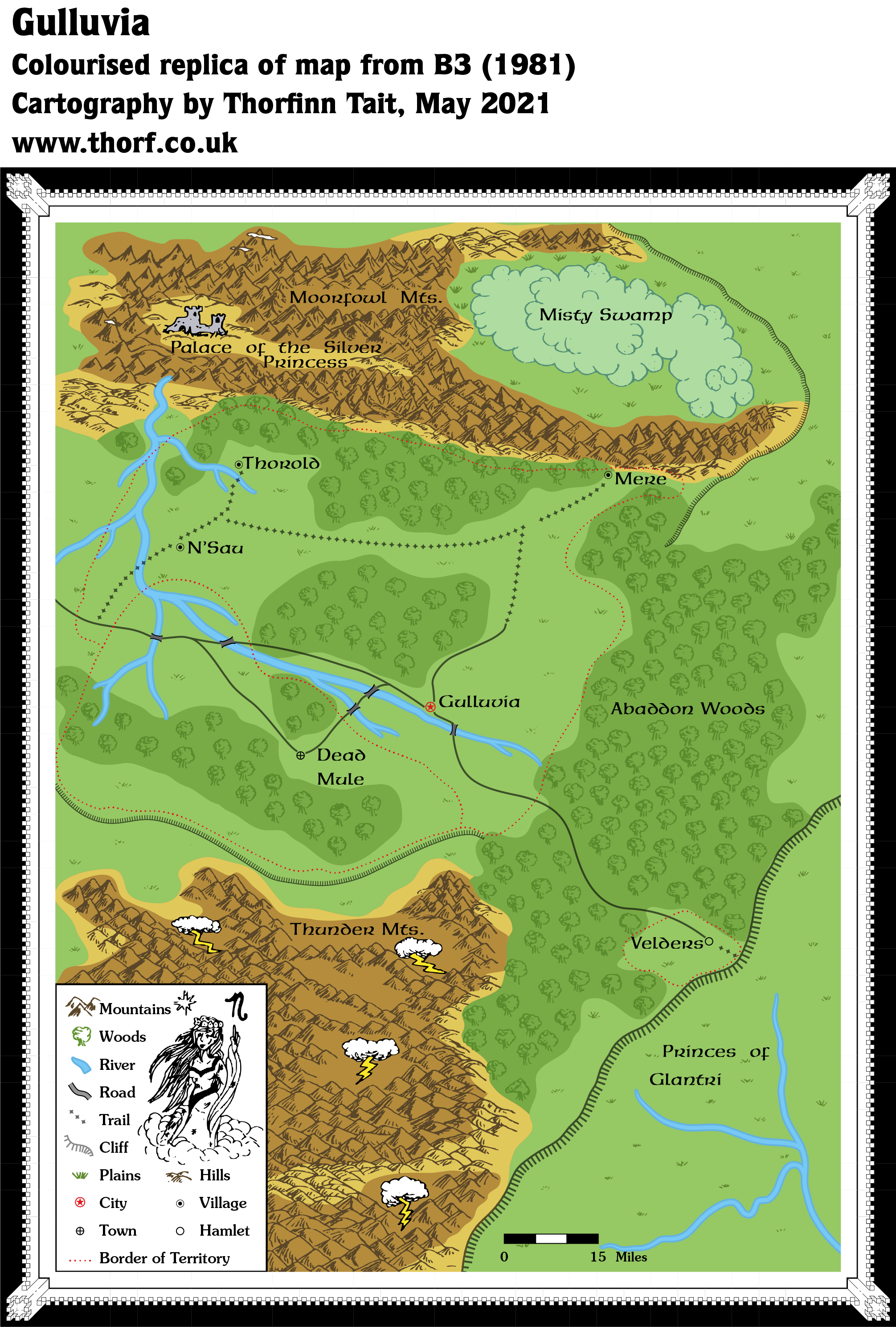
As most of you will already be aware, this map comes from the original, orange-cover version of B3 Palace of the Silver Princess, which was recalled as soon as it was printed. As such, it was pretty much unavailable back in 1981, being replaced by the green-cover version. It only became widely available in 2000, when Wizards of the Coast posted a PDF of it on their web site.
Gulluvia only existed in the orange-cover version of the module. It’s a fascinating map, as it places the nation up on the plateau that later came to be known as the Adri Varma Plateau, right next to Glantri.
Due to the module’s recall and destruction, Mystara’s designers were likely unaware of the nation up on the plateau. But as it happens nothing else was developed for the area. Fan creations added a number of things later, including at least two different adaptations of Gulluvia to the plateau: Michele Carpita’s adaptation in 2006, which Francesco Defferrari expanded into a more detailed version later the same year; and Andrea Barbiero’s in 2016, which placed the map more literally, adapting it to an 8 mile hex map.
Replica Map (May 2021)
Colourised replica of B3 (orange cover) map of Gulluvia
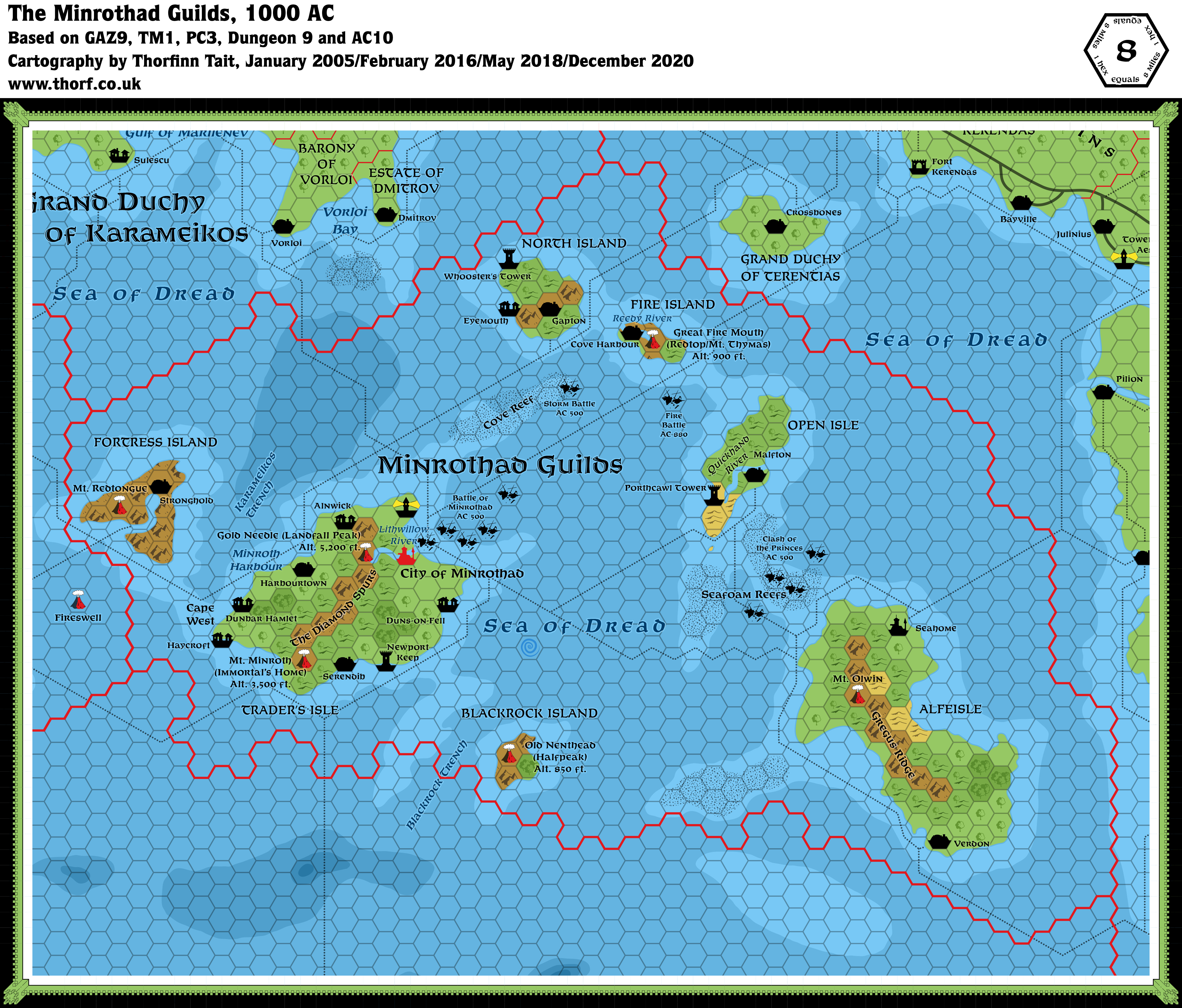
Minrothad, a nation of island peoples, is organized into a close-knit confederation of craft and service guilds. The country is commonly called the Minrothad Guilds, as they are known in commerce with the world’s trading communities. The Minrothad Guilds are located in the Minrothad Isles, formerly called the Isles of Dread. The islands are in the Dread Sea south of Karameikos between Ierendi and Thyatis.
from GAZ9 The Minrothad Guilds, by Deborah Christian and Kim Eastland
Map (December 2020)
Updated map of the Minrothad Guilds, 8 miles per hex
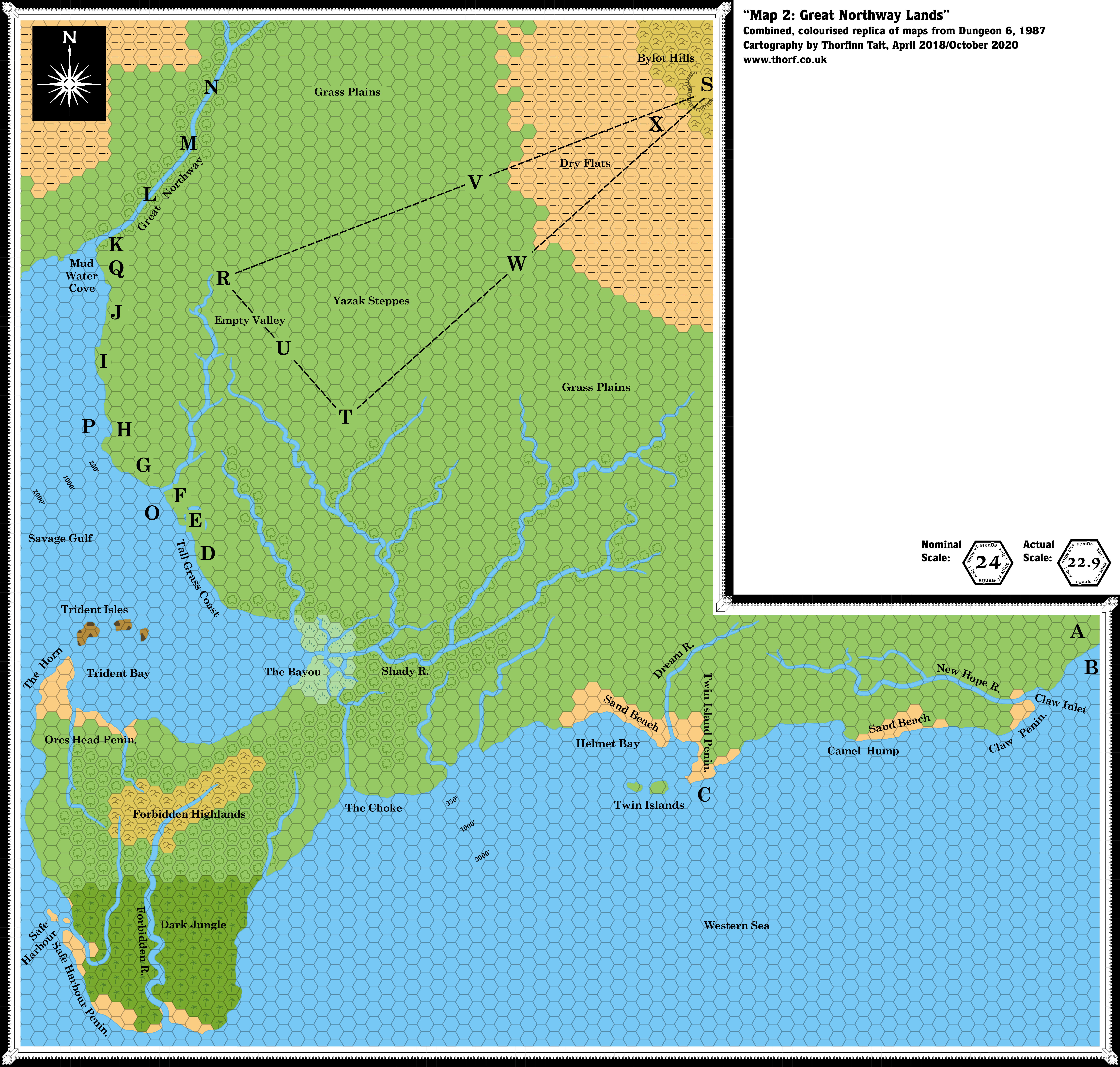
In Dungeon Issue #6, Merle Rasmussen expanded his design for the Savage Coast area (previously detailed in X9 The Savage Coast) into the adjacent northern lands. Christening these the Great Northway Lands, the adventure follows the search for ancestral tortle tribe egg-laying grounds, as well as the Great Northway River — which later came to be known as the Yalu River.
Since it’s based on X9’s map, this map is also scaled down slightly, and the nominal scale of 24 miles per hex is in fact more like 22.9 miles per hex. Part of the area was later covered in Red Steel and Savage Baronies — apparently with reference to this map — but unfortunately the maps do not fit together very well. In fact, this map’s depiction of Yalu Bay (here called the Savage Gulf) and its northern extent, the Mud Water Cove, doesn’t even fit perfectly with Brun’s continental map.
Replica Map (October 2020)
Colourised replica of Dungeon 6’s Great Northway Lands map, 24 miles per hex
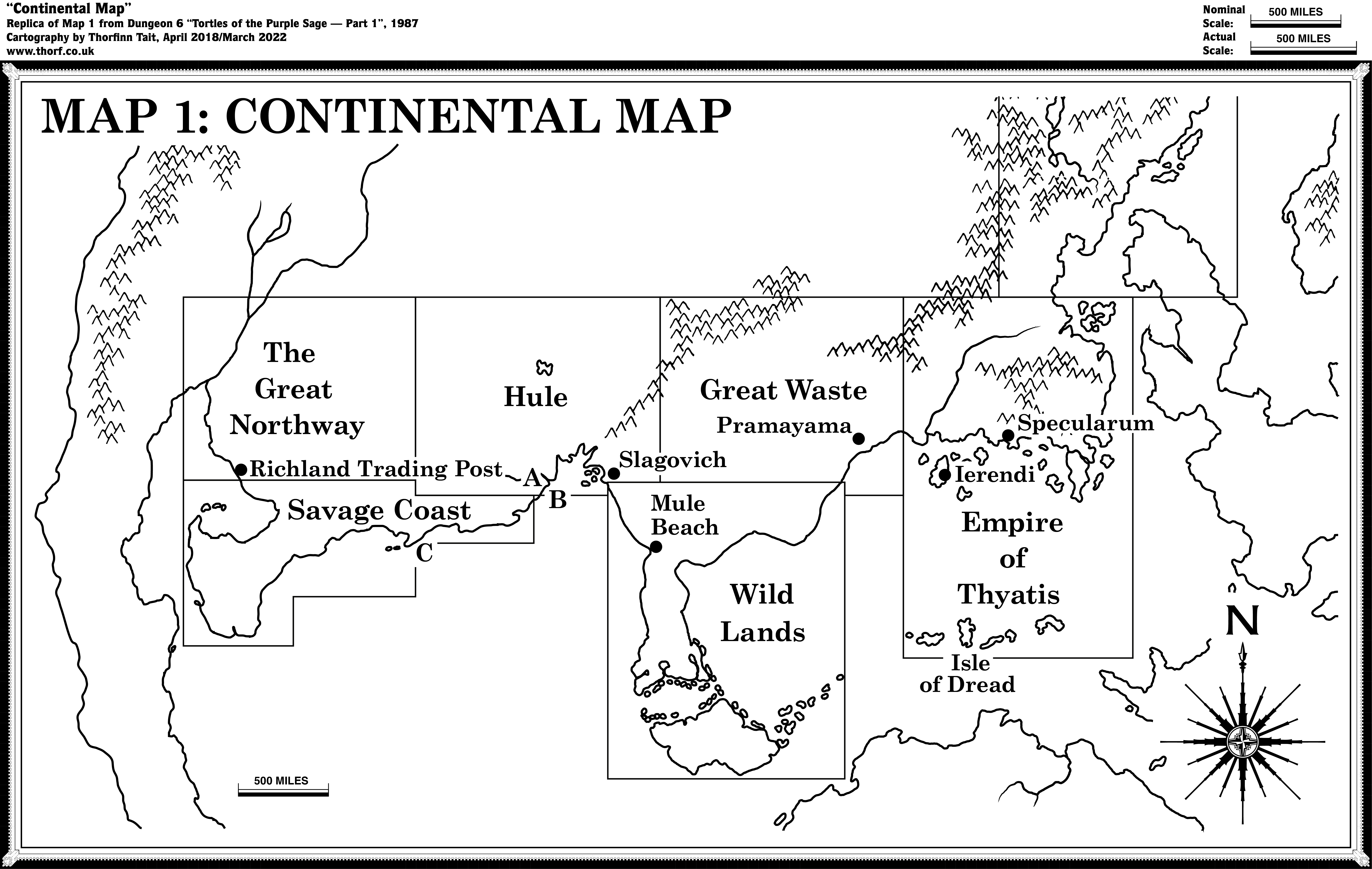
As well as the Great Northway Lands hex map, Dungeon Issue #6 also included a continental map showing the placement of that map along with those from X1, X4, X5, X6, X9, and CM1 on the continent. It’s a cropped copy of a similar map that appeared in X9, but of course with a box added. There’s not much else of note here.


")

 map of Gulluvia")