
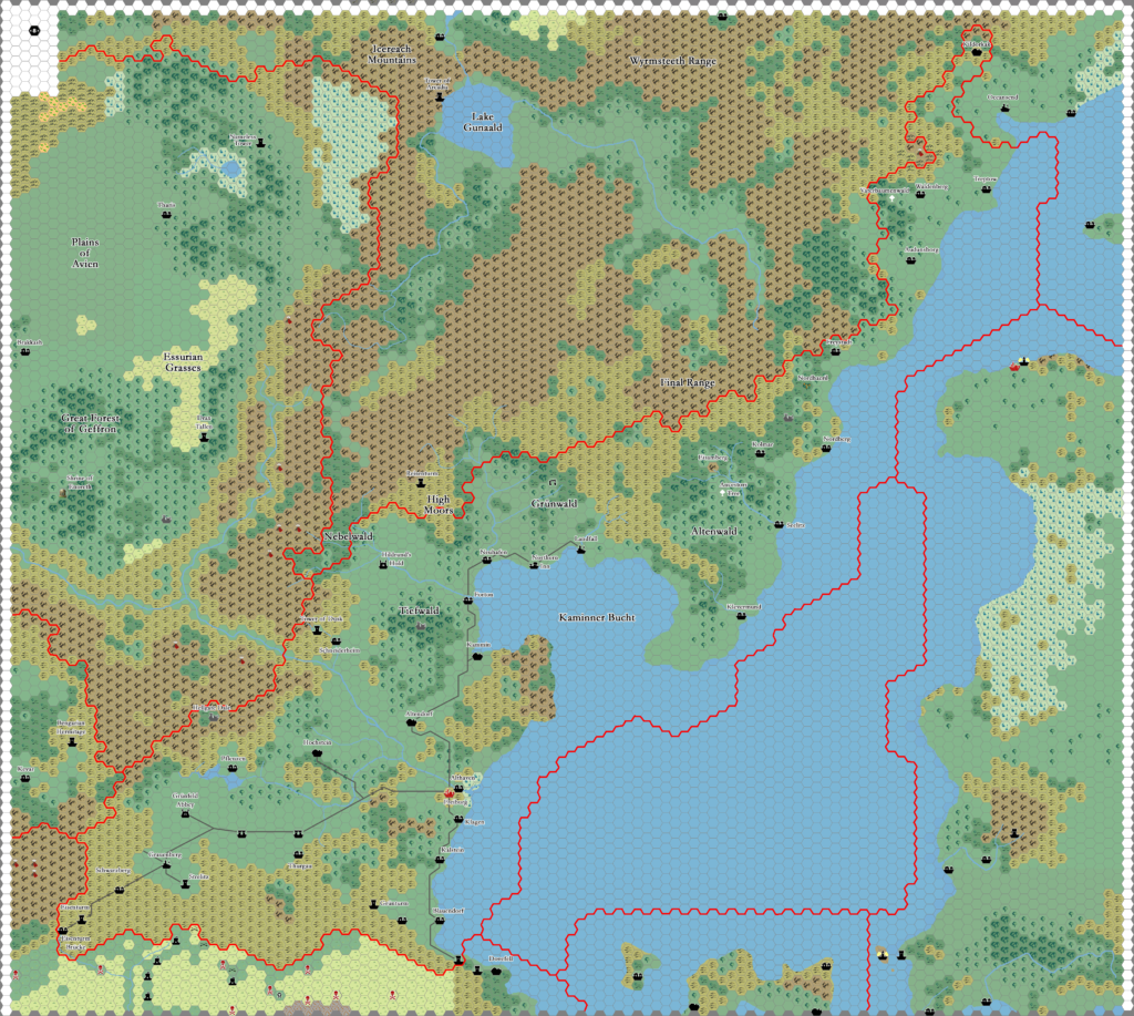
Heldann, 8 miles per hex
This cold, dark land […] faces the chilly waters where the Sea of Dawn meets the Alphatian Sea. In winter, piercingly cold winds blow down from Norwold. This is a harsh, hard land, a land where crops struggle to take hold in thin and rocky soil, a land where livestock which survives the harsh winters is thin, stringy, and mean. But it is, to many eyes, a beautiful land. Inland, the land is dominated by tall, hard-edged mountains; toward the sea, the arable lowlands look more welcoming than they actually are; everywhere, pine forests grow tall, deep, and dark.
from Poor Wizard’s Almanac, by Aaron Allston
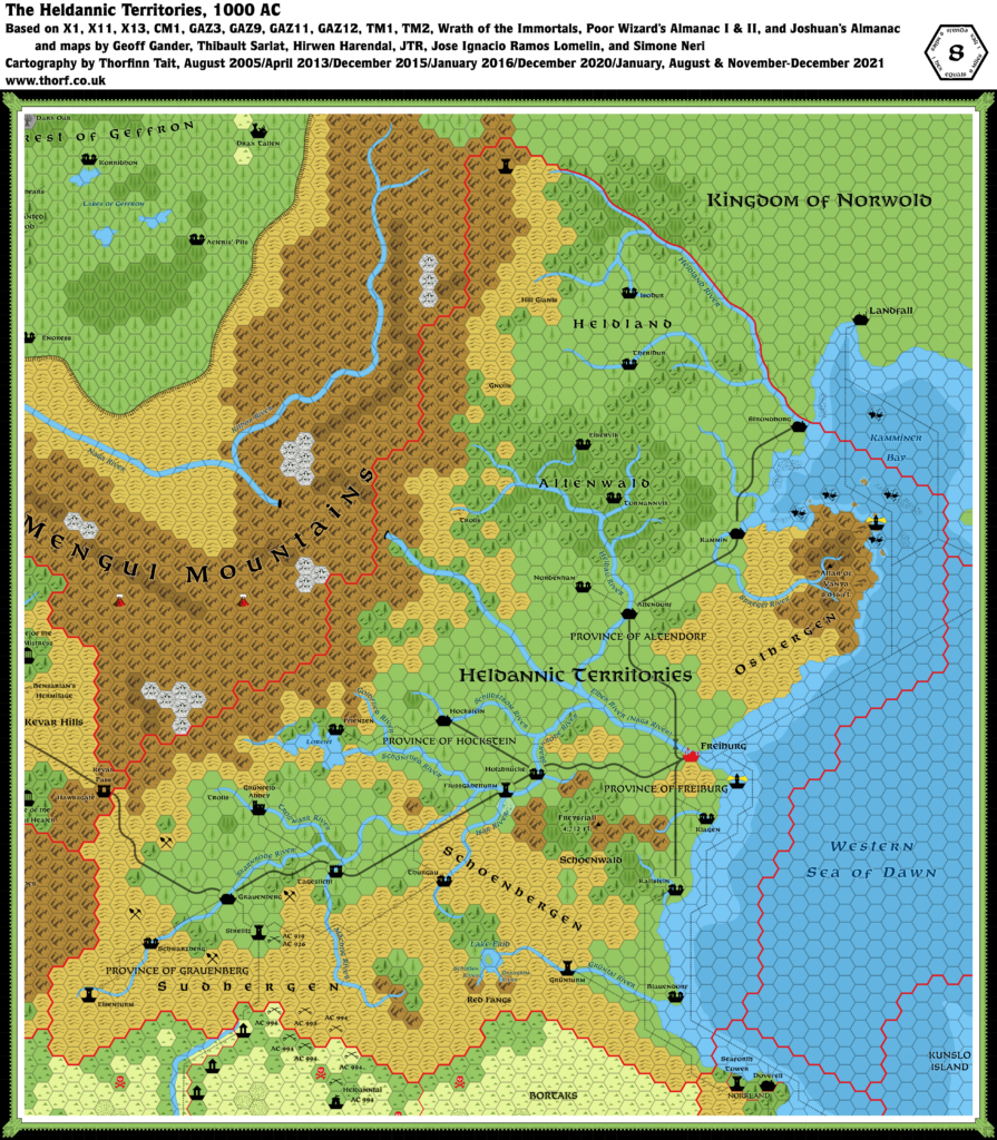
Map (December 2021)

Sources
- CM1 Test of the Warlords (1984) (PDF at DriveThruRPG)
- X1 The Isle of Dread (1981) (PDF at DriveThruRPG)
- X11 Saga of the Shadow Lord (1986) (PDF at DriveThruRPG)
- X13 Crown of Ancient Glory (1987) (PDF at DriveThruRPG)
- X13 Isle of Erid Overview, 0.5 miles per hex
- GAZ3 The Principalities of Glantri (1987) (PDF at DriveThruRPG)
- GAZ9 The Minrothad Guilds (1988) (PDF at DriveThruRPG)
- GAZ11 The Republic of Darokin (1989) (PDF at DriveThruRPG)
- GAZ12 The Golden Khan of Ethengar (1989) (PDF at DriveThruRPG)
- TM1 The Western Countries (1989)
- TM2 The Eastern Countries (1989)
- Wrath of the Immortals (1992) (PDF at DriveThruRPG)
- Poor Wizard’s Almanac (1992)
- Heldannic Territories, 1 sq. equals 18 miles
- Poor Wizard’s Almanac II (1993) (PDF at DriveThruRPG)
- Heldannic Territories, 1 sq. equals 18 miles
- Joshuan’s Almanac (1995) (PDF at DriveThruRPG)
- Heldannic Territories
- Heldann Articles by Bruce Heard (1998-1999), archived at the Vaults of Pandius
- Population Demographics (1998)
- Heldannic Knights — Historical Timeline (1999), Part I and Part II
Fan Sources
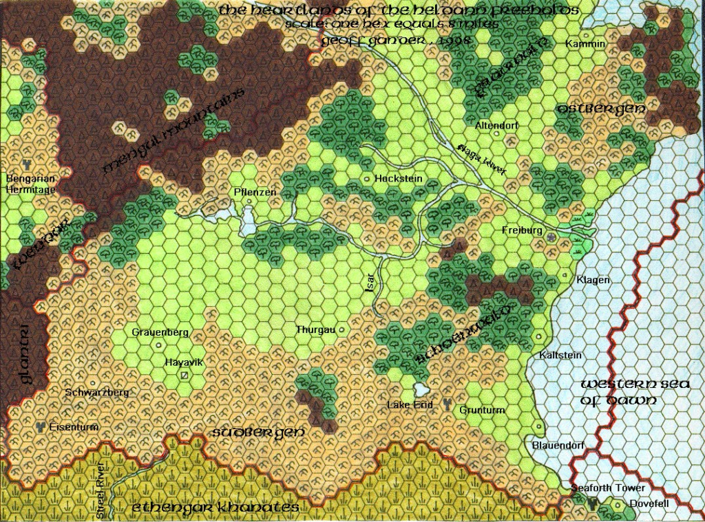
- Geoff’s Heldann, 8 miles per hex (1998)
- Thibault’s Heldann, 8 miles per hex v1 (2000), v2 (2001), v3 (2004), v4 (2004)
- Darkblood’s Known World, 8 miles per hex (2000-2002)
- Heldann, 8 miles per hex (2001) by Tim Roberts
- Heldann, 8 miles per hex (2002) by Hirwen Harendal
- The Heldannic Empire Gazetteer (2005) by Thibault Sarlat
- Gaz F7 The Heldannic Order (2007) by JTR (PDF at the Vaults of Pandius)
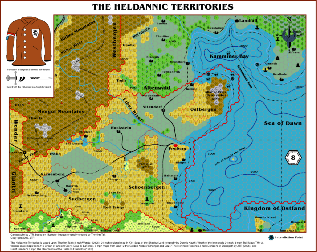
- The Heldannic Territories, 8 miles per hex (2007) by JTR
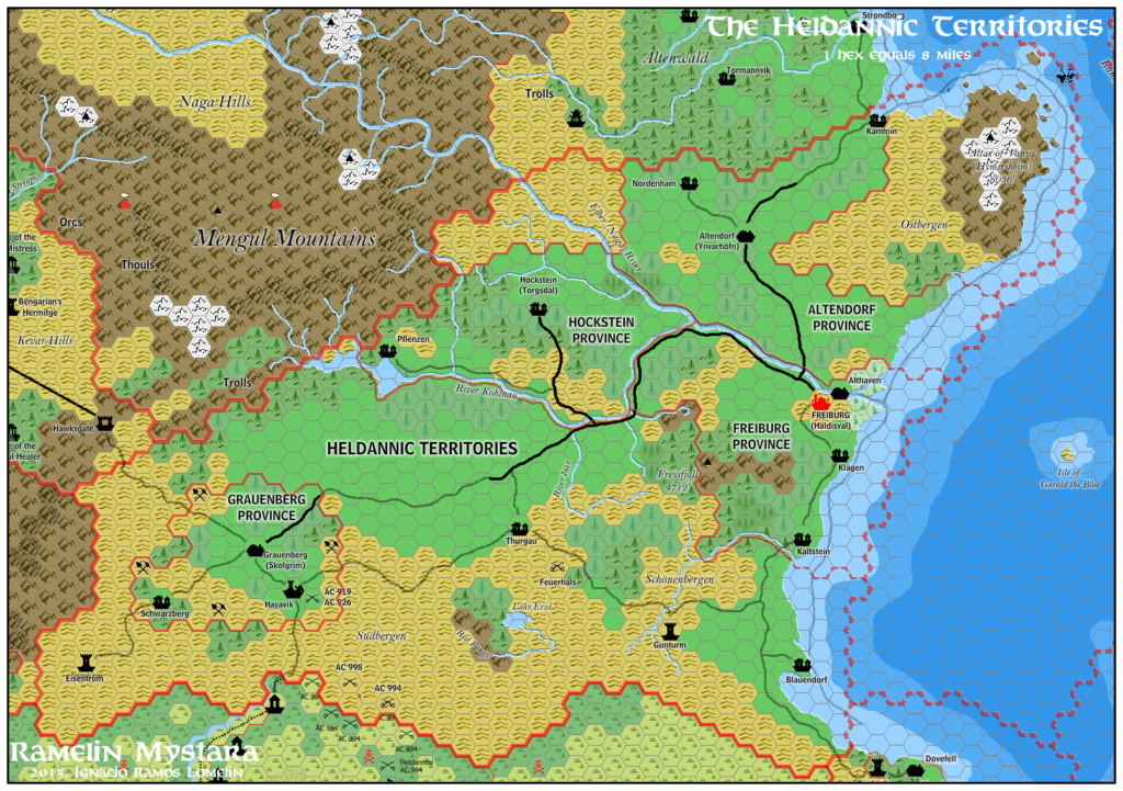
- The Heldannic Territories, 8 miles per hex (2015) by Jose Ignacio Ramos Lomelin
- Norwold, 24 miles per hex (2015) by Simone Neri
- Additional Suggestions for Heldann (2021) by Geoff Gander
Comments
In many ways, Heldann is one of the holy grails of Mystara lore. Had the Gazetteer series continued, it would surely have been the first choice to be GAZ15. (In fact, at one point Heldann was slated to be just that — see 1993 in this old planning document from Bruce Heard.) But, as we all know, the Mystara product line ceased publication before that could come to pass.
This left us with a scattered set of references, and a few fragments from the edges of existing maps — though only TM2 added anything in the way of detail, and unfortunately only to a very small area. Despite Heldann getting maps in three of the four Almanacs, the lack of a Gazetteer and a detailed map left the area tantalisingly incomplete.
Not to be out-done, Bruce Heard posted a slew of articles in the late 90s, developing the nation bit by bit over the course of a couple of years. These bits and pieces all add up to quite a significant amount of material, although it’s not quite a full Gazetteer. I have listed the most relevant of these (for the purpose of creating a map, that is) among the Sources above.
Community Creations
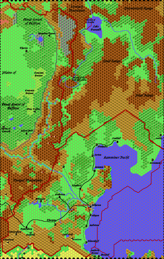
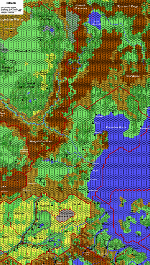
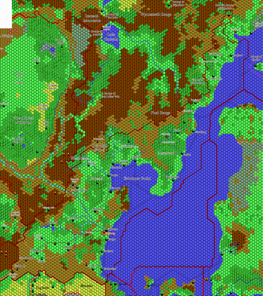
Meanwhile, the fans were not idle. Geoff Gander produced and posted a map of Heldann at 8 miles per hex. This was the first of many fan-made maps of the nation, as you can see from the list of Fan Sources above. Each of these maps built on previous work in the area, slowly adding more and more detail.
And it wasn’t just maps: the fan-written Mystaran Almanac series consistently included events for Heldann. Then in 2005, Thibault Sarlat created his own Heldannic Empire Gazetteer, expanding on Bruce’s articles, although regrettably its unfinished parts prevented him from sharing it widely among the community at the time. After that, JTR wrote and posted Gaz F7 The Heldannic Order in 2007, also based on Bruce’s articles. Both of these gazetteers had accompanying maps.
Atlas Heldann
So as it turns out Heldann is far from a vacuum. In fact, there is a wealth of information about it, and the community has now created many maps of the nation.
The Atlas of Mystara exists to bridge the gap between officially published Mystara and fan-created additions to Mystara. The first priority is to create consistency between official sources, but for unmapped regions such as Heldann, the next priority is to map out these areas while creating as much consistency between community material and official products as possible.
Which brings us to the Atlas version of Heldann, presented in the map above and the accompanying (extensive) notes below. As you would expect, I have striven to maintain consistency first with the Atlas model, derived fully from official sources (most notably X11 and CM1, as well as Wrath and the Almanacs); and then to adapt fan-created sources to the resulting map. I’ve made extensive reference to Thibault’s gazetteer as well as JTR’s Gaz F7, and I’ve attempted to maintain compatibility with both of these books.
As with all updated maps, I am fully open to feedback, and I will be happy to discuss revisions to the map. But please do check the notes below, as my reasoning for various decisions should then become clear.
The Norwold Conundrum
Heldann sits at the join between the Known World and Norwold. Further complicating matters, its primary source, X11, is incompatible with CM1’s Norwold. These inconsistencies must be solved in order to draw a map of Heldann.
The Atlas solution comes from the chronological model of Mystara being built up in the Let’s Map Mystara project. The first release is based on Mystara 1986, in which all the initial sources for Heldann are present and resolved.
Notes
- Borders — CM1 established Norwold’s southern border, and thus Heldann’s northern border, as a line running inland northwest from the coast just west of Landfall. X11 changed this to an east-west line extending inland from roughly the same area, bisecting the Altenwald. The resulting triangle of land (between the Altenwald and the Heldland River) has since become known as the Heldland, with the differing border adopted into the setting as indicating somewhat conflicted land. The Atlas currently places the Heldland within Heldann’s territory as of 1000 AC, though the actual status on the ground may not match the ideals of the map.
- Coastline — Combining all the sources to create a synthesised coastline that includes all the most interesting elements.
- Forests — X11’s original view of Heldann was entirely treeless. However, descriptions of the nation invariably stress its deep pine forests, and every map since has added at least a little tree cover.
- Altenwald — Origin: Geoff Gander. The forest itself appeared first as a block of forested hills in Wrath, then as a block of unnamed forest in the Almanacs. The name appears on Geoff’s map, and Bruce Heard refers to it in his Historical Timelines.
- Schoenwald — Origin: Geoff Gander.
- Heldland — Origin: Bruce Heard.
- Kamminer Bay — Origin: Thibault Sarlat.
- Lake Erid — Origin: X13. Geoff incorporated the lake in his original map.
- Ostbergen — Origin: Geoff Gander.
- Red Fangs — Origin: X13, though the twin mountain hexes (or at least mountains around this location) were present in the original X1 map. Note that Wrath moved the border with the Ethengar Steppes right up to East Fang. Geoff Gander’s map seems to be based on this. The Atlas model is mostly based on X1, which explains the difference in placement of these mountains.
- Rivers — X11 featured a single river flowing east from the Mengul Mountains across Heldann to the sea. Subsequent maps have added a few more rivers. The Atlas view is to look at water drainage basins and draw in rivers as required based on terrain and settlement locations.
- Elber River — Origin: X11, as the Naga River. This river originally comes from X11, where a section of it was obscured by the Mengul Mountains label. Wrath of the Immortals took this to be a section of the river going underground, adding tunnel-like symbols at the entrance and exit points. Although this was surely not X11’s intent, it is certainly an interesting idea, so the Atlas has adopted it. The local Heldannic name Elber River comes from JTR’s map and gazetteer.
- Graugrim River — Origin: Thorfinn Tait. The eastern tributary of Lake Erid, running from East Fang.
- Grüntal River — Origin: Thorfinn Tait.
- Heldland River — Origin: Bruce Heard.
- Isar River — Origin: Geoff Gander. Lengthened to extend further into the Schoenbergen.
- Naga River — See Elber River above.
- Scholten River — Origin: Hirwen Harendal, using the spelling “Sholten”. Hirwen had this as the westernmost river, running from south of the Kevar Pass to Lake Lorelei. Atlas Heldann considers Lorelei to be on the other side of the hills dividing southwestern and northeastern Heldann, so this river went unused. Instead, the name has been reused for the small tributary running from West Fang to Lake Erid.
- Settlements — Heldann started out with just a capital, but the settlements have proliferated with every new iteration of the map.
- Altendorf — Origin: Wrath. Population: 4,800 (Bruce Heard, 1010 AC; Gaz F7, 1000 AC), 1,800 (Thibault, 1020 AC).
- Blauendorf — Origin: TM2. Population: 840 (Thibault, 1020 AC).
- Eisenturm — Origin: Geoff Gander. Population: 750 (Gaz F7, 1000 AC), 910 (Thibault, 1020 AC).
- Forton — Origin: Joshuan’s Almanac. Population: 5,100 (Thibault, 1020 AC).
- Freiburg — Origin: X11. Appeared on many smaller scale maps starting in X11, then GAZ9 and GAZ11’s trading maps, Wrath, and finally the Almanacs. The exact location comes from TM2’s direction, “16 miles to Freiburg”, together with a desire to place it on the coast — although previous maps (beginning with Geoff Gander) placed it a few hexes inland. Various population figures exist for Freiburg, from 15,000 (Bruce, 1010 AC), 15,000 with 10,000 in the surrounding areas (Gaz F7, 1000 AC), to 25,000 (Almanacs, 1010-1012 AC), to 35,000 (Thibault, 1020 AC). Whichever is adopted, Freiburg is clearly a City. See also Haldisvall.
- Grauenberg — Origin: Wrath. Population: 3,800 (Bruce, 1010 AC; Gaz F7, 1000 AC), 8,000 (Thibault, 1020 AC).
- Grünturm — Origin: TM2 as “Grunturm”; Thibault has Grünturm. Population: 650 (Gaz F7, 1000 AC), 450 (Thibault, 1020 AC).
- Haldisvall — Origin: Bruce Heard. Freiburg was called this until 950 AC.
- Hayavik — Origin: GAZ12. Strelitz was built on the ruins of this village.
- Hockstein — Origin: Wrath. Population: 4,300 (Bruce, 1010 AC; Gaz F7, 1000 AC), 3,500 (Thibault, 1020 AC).
- Holzbrücke — Origin: Geoff Gander.
- Kaltstein — Origin: TM2. Population: 710 (Thibault, 1020 AC).
- Kammin — Origin: Geoff Gander. Population: 2,300 (Thibault, 1020 AC).
- Klagen — Origin: TM2. Population: 430 (Thibault, 1020 AC).
- Neuhafen — Origin: XXX. Population: 830 (Thibault, 1020 AC).
- Pflenzen — Origin: Geoff Gander. Population: 650 (Thibault, 1020 AC).
- Schneiderheim — Origin: Thibault Sarlat. Population: 540 (Thibault, 1020 AC).
- Schwarzberg — Origin: Geoff Gander. Population: 625 (Gaz F7, 1000 AC), 500 (Thibault, 1020 AC).
- Skolgrim — Origin: Bruce Heard. Grauenberg was called this until 960 AC.
- Strelitz — Origin: Thibault Sarlat. Built on the ruins of Hayavik.
- Thurgau — Origin: Geoff Gander. Population: 1,700 (Thibault, 1020 AC).
- Schoenbergen — Origin: JTR.
- Sudbergen — Origin: Geoff Gander.
- Trails — X11 provided a bare minimum of trails: from Wendar to Freiburg, with a branch south to Ethengar on the way; and along the coast from Freiburg, north to Norwold and south to Vestland. The status of these trails as roads or lesser trails is slightly ambiguous in X11. Wrath changed most of these to roads, with the exception of the trails shown on TM2 south of Freiburg. The Almanacs again reverted these to trails, although once again this is ambiguous. Fan-made maps largely adapted Wrath‘s roads, changing the Ethengar link (and sometimes more) back to trails. The Atlas follows in largely the same way.
References
Thanks to:
Geoff Gander, Bruce Heard, JTR, Jose Ignacio Ramos Lomelin, Ricardo Matheus, Simone Neri, Tim Roberts, Thibault Sarlat
Past and Future Versions of this Map


26 December 2021 @ 12:26 am
Hi Thorf
Nice map
In your list of surces you forgot my work you viewed about 2 years ago on the region.
So here links(even if they are unfinished, they hold ignificant information, especially in resolving the Ethengar Plateaux altitude and Heldann altitudes to be resolved logically).
Research you did help me with
https://www.deviantart.com/6inchnails/art/Erid-Lake-study-788529937
https://www.deviantart.com/6inchnails/art/Heldann-Spires-Test-788530903
Results (missing minor details, altitudes,Ethengar Camps/labels, as well as finishing the Hakomon locations)
https://www.deviantart.com/6inchnails/art/Ethengar-hex-1-N-780327662
+
https://www.deviantart.com/6inchnails/art/Ethengar-Northeast-1mile-hex-782037337
The River in your map here from Lake Erid, is not from X1 or X11(map and texts), and neither fanon. I am curious why you created this. I had something similar, yet not from the lake but from the Plateux edges.
26 December 2021 @ 10:47 am
Thanks for adding these links!
A lot of the rivers on this map are my own invention. I have adapted rivers added by others, too. The general idea is just to create drainage for the land, which otherwise was completely missing from official maps — not because it shouldn’t exist, just because of the scale.
For Lake Erid, I thought it was silly that there’s no drainage from the lake to the coast. And there must also be streams from the nearby mountains, although they are likely quite minor. What I’ve done looks quite similar to your map, but with Lake Erid joined up to the east-flowing system.
26 December 2021 @ 12:43 am
Oops I did mention X11, yet meant X13 with Gyl Erid Castle in Lake Erid
Which is much smaller than you mapped if following the canon size btw, as the X13 map did use 1/2 mile hexes
The Lake I placed more east, I based its location on Geof’s map, yet followingthe canon sources that is as far as I checked not the location of Lake Erid. That said I could not discard Geoff’s work and created another lake following his dimensions and location.
Hope this helps
Robin
26 December 2021 @ 9:44 am
Hi Robin! Thanks for chiming in. 🙂
I disagree about Lake Erid being much smaller. X13’s map is clearly marked “1 hex = 8 miles”. All I have done is fit the Heldann part of the map as best I could, and traced the lake. The placement is pinned to the border.
However, the fact is, X13’s map doesn’t fit with the other Known World maps. At all. It has similar details, but they’re all in the wrong places. Trying to place it using the marked borders seems impossible. Lining up Rhoona and Norrvik is better, but still lots of bits are completely out of sync — and this throws the scale completely out. It also requires changing the aspect ratio of the map, squashing it on the north/south axis.
Because of all this, I decided to use the map in a more local way, cropping to just the Heldann corner and the Heldann/Ethengar border. And I kept the marked scale of 8 miles per hex. The result is what you see on my map above.
To sum up, X13 is a highly problematic source. However you deal with it, there is some interpretation involved. It’s thus not surprising that each person who has tried to adapt it has done so slightly differently.
Also, there have been numerous different fan-made maps of Heldann at this point. Each of them shows a slightly different interpretation, generally building on the previous maps but with some tweaks and added details. It’s not possible to add these all together into a single map as is, because they conflict in all sorts of ways.
My solution has been to adapt things where they don’t fit. For example, Hirwen Harendal’s map has a completely different river system, including names for the rivers. It’s similar in intention to mine — providing drainage for the land by adding a river system running to the coast — but I split mine into two sections, with the hills that separate Hockstein and Grauenberg provinces as the dividing line, while Hardenal’s rivers had just a single network there. I didn’t want to waste the names, so I reassigned them elsewhere in Heldann. The little river from West Fang to Lake Erid is one of these.