")
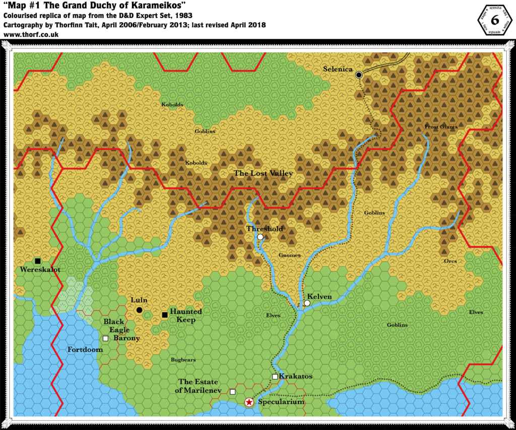
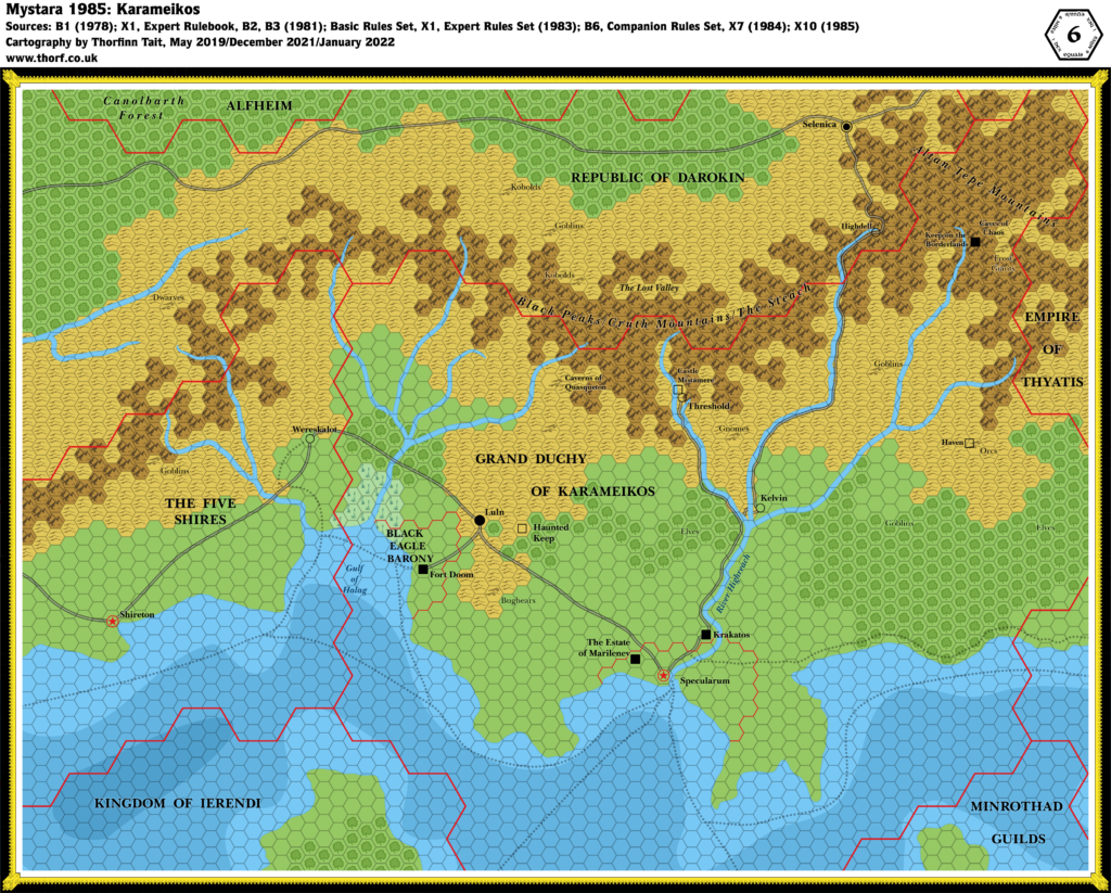
Karameikos, 6 miles per hex (1986)
In 1986, B10 Night’s Dark Terror added more detail to the northeastern section of Karameikos than had yet been given to anywhere in Mystara. Fitting it in with the previous maps was not easy, as the maps do not match up perfectly. But I believe I have found the best fit that doesn’t involve warping the maps, thus preserving the integrity of all the maps while still arriving at a consistent set.
This map incorporates all of the details from B10’s Eastern Karameikos, Foamfire River, and Lost Valley maps that will fit at the 6 mile per hex scale. The mountains have been adapted to be closer to B10’s maps, as have the rivers, forests, and settlement locations. On the other hand, where this map had more detail, those have been preserved and reflected back into the larger scale maps.
The end result is that this is the ultimate pre-Gazetteer Karameikos map; soon after, 1987 would see the release of GAZ1, and many more expansions and revisions.
Chronological Map (February 2022)
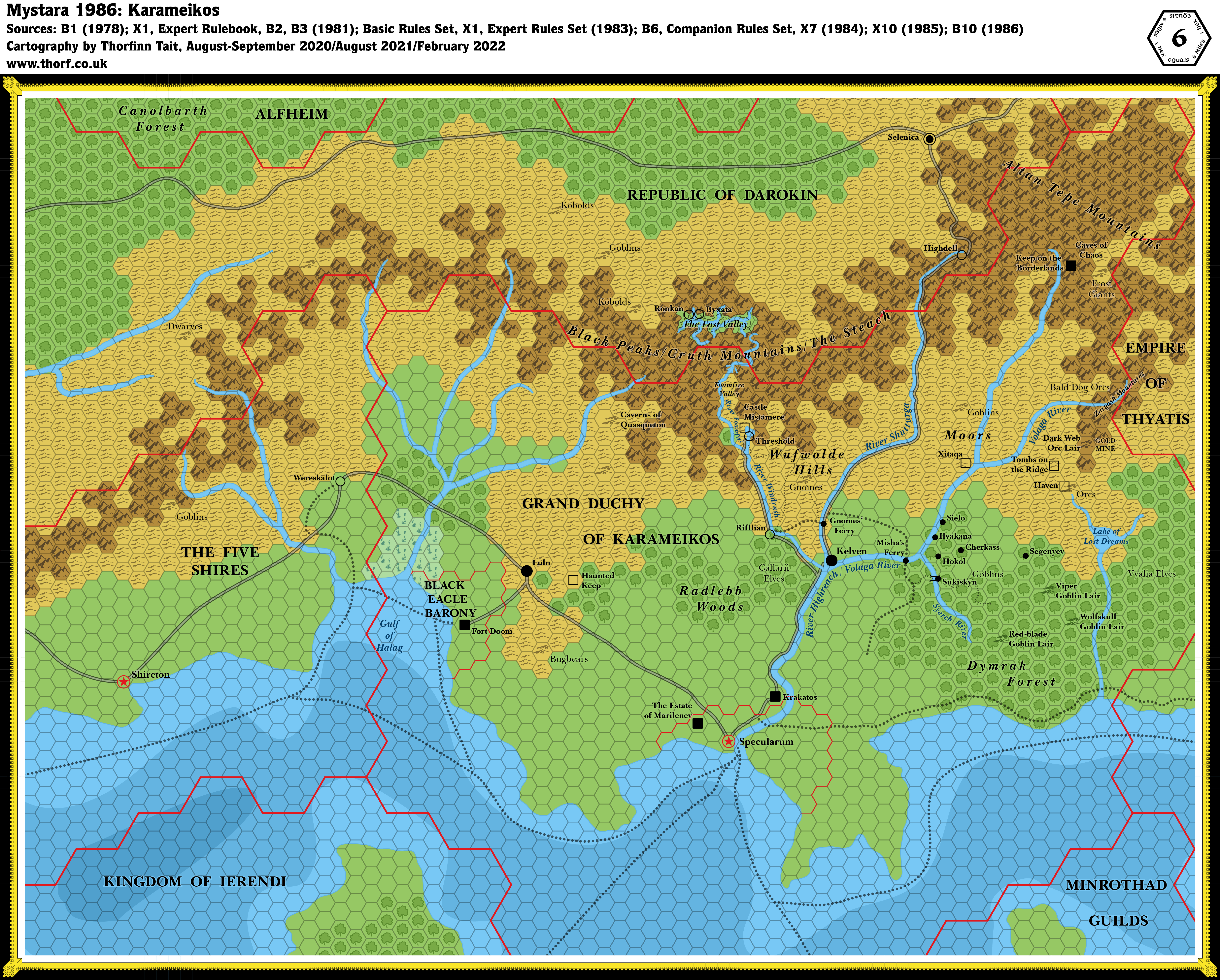
This map is part of the Mystara 1986 series of chronological maps. It is an updated map, incorporating all available sources and made internally consistent with other maps in its series. But it only uses sources published in or before 1986.
For more information, see Appendix C: Cartographic Chronology.
Sources
- Mystara 1985
- B10 Night’s Dark Terror (1986) (PDF at DriveThruRPG)
Revisions
For detailed notes, see the posts for each individual source map at the links above.
- Roads & Trails — B10 had four levels of trails and roads. These have been adapted to a single road type and two trail types on this map.
- Terrain — The 6 mile per hex mountains and hills have been adapted to more closely fit those in B10’s maps, except in a few locations where this map’s mountains were more detailed, and have thus been used to enhance the 3 and 2 mile per hex maps instead. In general the forests on this map were more extensive, so they have been added to the larger scale maps, except in a few situations where those maps had more detail.
References
- Let’s Map Mystara 1986 — the original project thread for this map
- Let’s Map Mystara Together discussion thread at The Piazza (link leads to this map’s post)
- Karameikos at the Vaults of Pandius
Thanks to:
Paul Dupuis, Travis Henry, Fabrizio Hockey Nuzzaci

")
")

8 February 2022 @ 9:31 pm
Interesting that you note the mountains because B10 was pretty much the only map to follow the mountains from the expert set, which were kinda drastically changed with gazetteer map.
8 February 2022 @ 9:57 pm
Right. I suspect that the GAZ1 map was eyeballed rather than carefully calculated. There’s even a whole column of hexes missing, so it doesn’t even line up with the 24 mile per hex borders properly. Merging all of this stuff together for Mystara 1987 is going to be a task and a half. I’ve already started on it, but I’m going back and forth on how to reconcile this map with GAZ1’s. Should I just take GAZ1 to be correct and go with that? Should I fix the missing column of hexes? Or should I try to create a hybrid that neatly combines all the details from this map and GAZ1?
It’s not an easy question to answer, not least because this boat has sailed long ago, and a veritable ton of other maps have since been made based largely on GAZ1. Correcting “errors” sounds like the best idea until you consider that — and also the fact that correcting an error in GAZ1 will have a knock-on effect on all the surrounding nations.
I think a neat hybrid is the best idea. The missing column can stay missing, as it is solved by neighbouring maps anyway. On the other hand, I have no compunctions against revising terrain and exact settlement locations. So I will change GAZ1’s mountains to better match this map’s — except where GAZ1’s seem more detailed.
8 February 2022 @ 10:12 pm
Another possibility with GAZ1 is that it was simply drawn from the 24 mile per hex map, with little or no reference to the 6 mile per hex maps. That would also explain an awful lot.