")
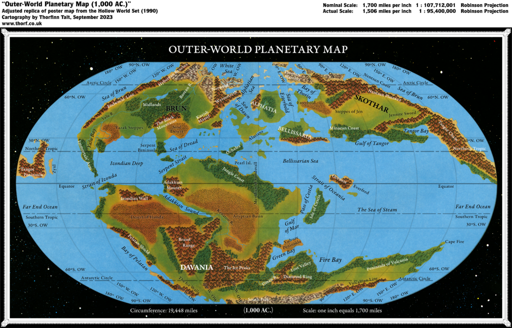
Outer World (1985)
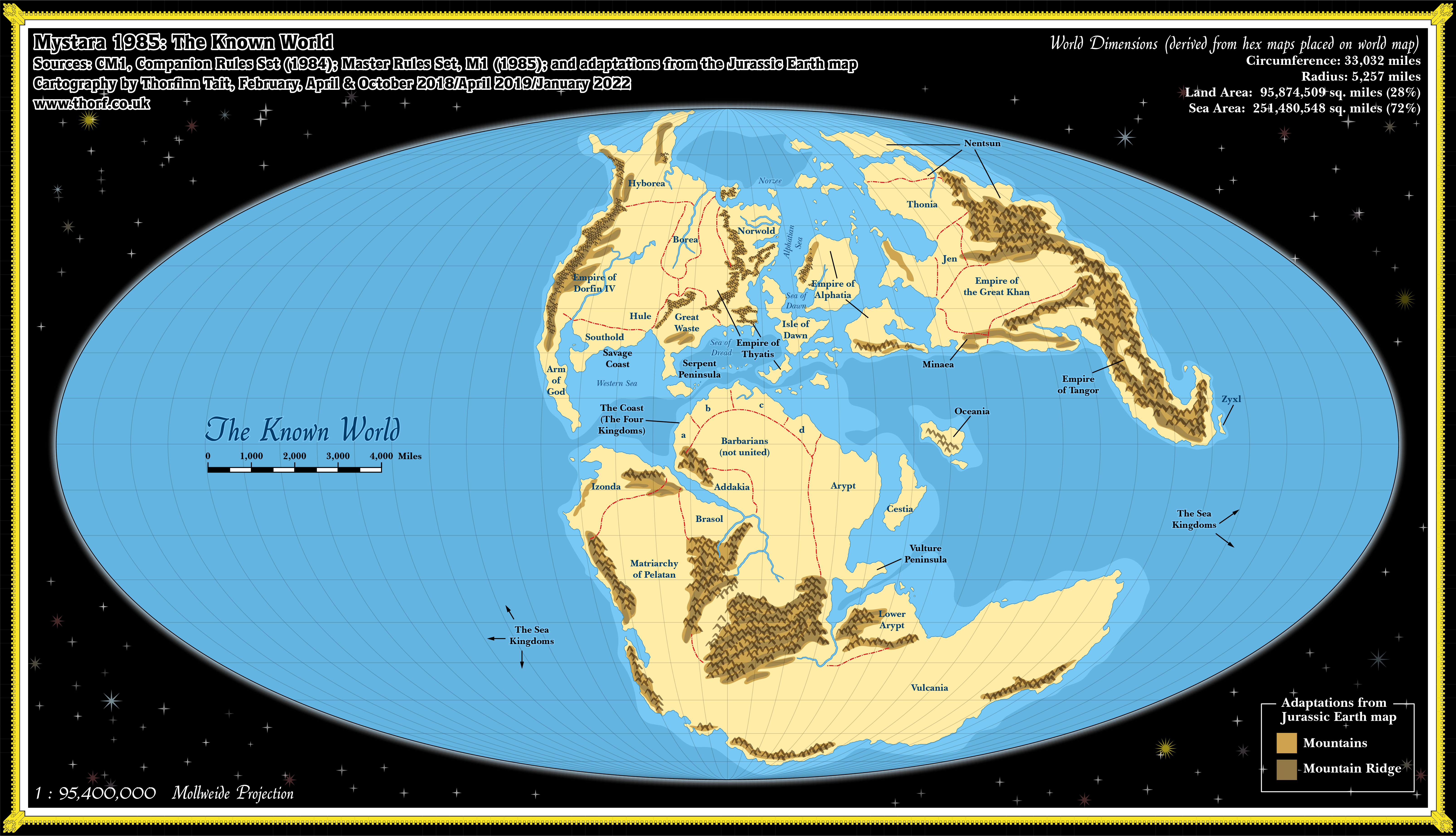
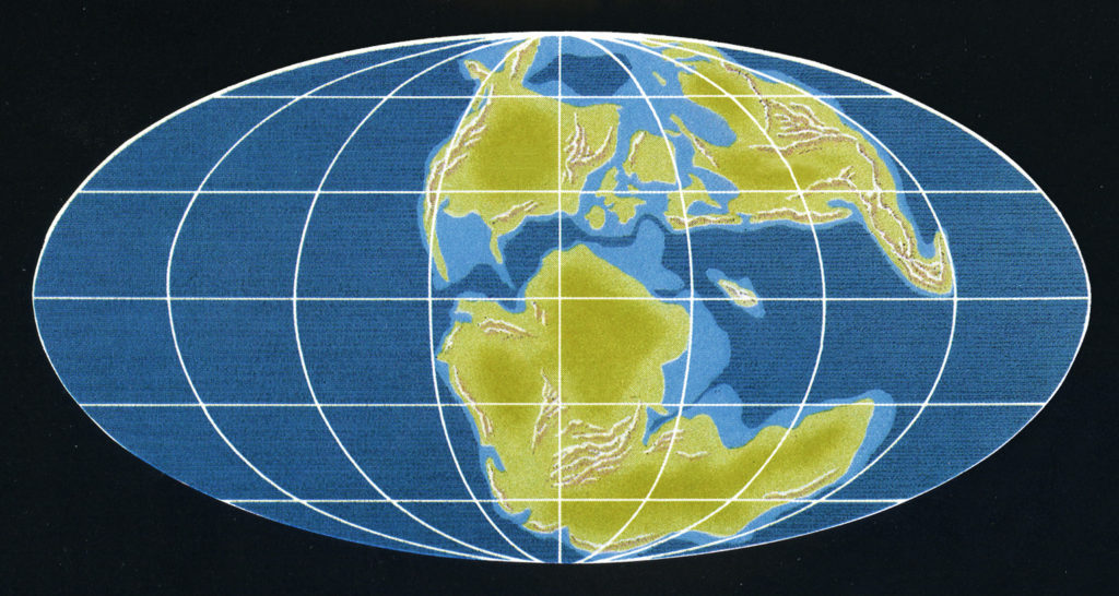
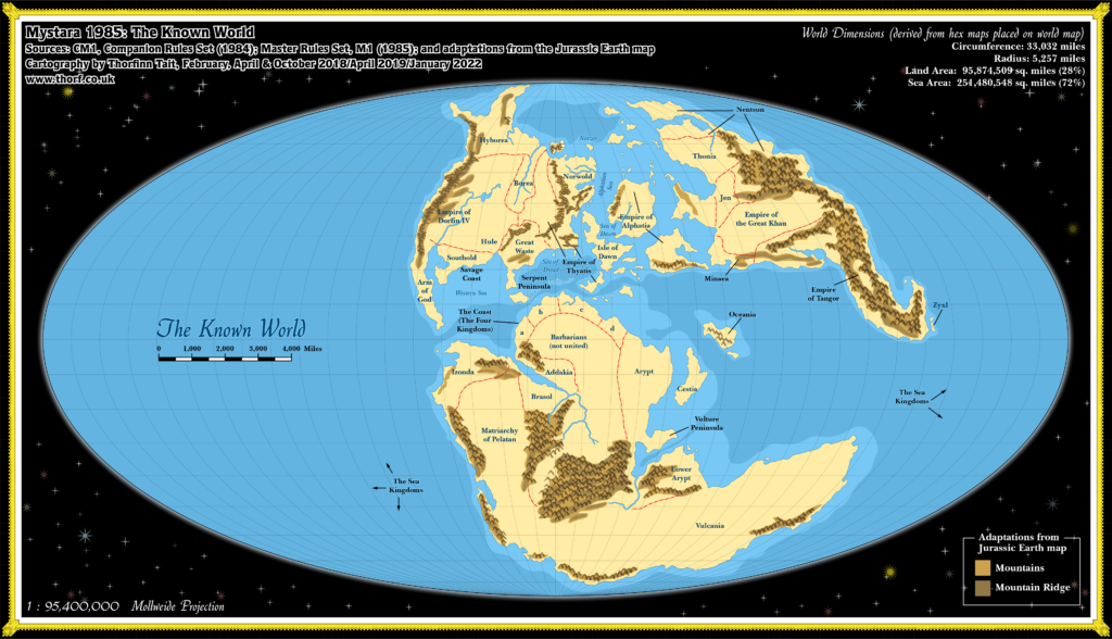
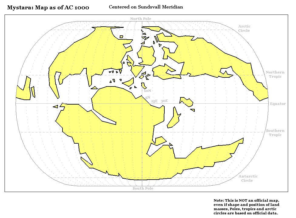
The most important development of 1985 was surely the revelation of the world map in the Master Rules Set. That map not only provided a view of the entire world for the first time, but it also revealed the projection used in almost all of Mystara’s maps, past, present and future. Due to the way the map was presented, with the edges of the map cropped and the border deleted, this wasn’t immediately apparent, but it can be derived from the Jurassic Earth map, allowing the whole world, including all the maps derived from this one, to be georegistered.
Of particular note is the very large ocean covering half of the world. The Master Set map cropped this out completely, but that doesn’t mean it was deleted; in fact, it is “baked in” to the map due to the projection, which is easily verified by trying to place the world map onto a globe. Nevertheless, its absence from the Master Set map makes the “addition” of the huge ocean somewhat controversial among fans.
The dimensions listed here are derived from a placement of the hex maps on top of this map, thus allowing the whole world to be measured. Later developments will introduce other figures, but implementing these would require the rescaling of all other maps.
As with the Brun maps, at this stage the name “Outer World” is an anachronism; the Hollow World is still 5 years away. I’m using it for ease of reference, but at this stage the world was labelled simply “The Known World”. In fact, this was the first appearance of this name in print.
Chronological Map (January 2022)
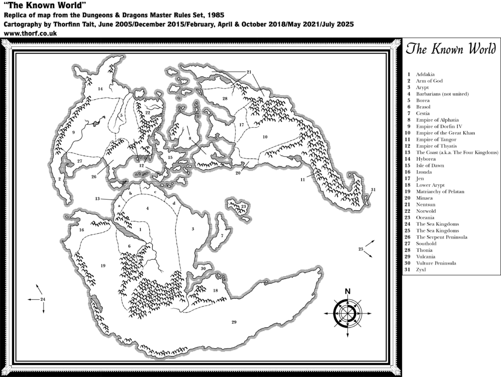
This map is part of the Mystara 1985 series of chronological maps. It is an updated map, incorporating all available sources and made internally consistent with other maps in its series. But it only uses sources published in or before 1985.
For more information, see Appendix C: Cartographic Chronology.
Sources
- Mystara 1984
- Continents in Collision (1983) by Time Life
- “Jurassic Earth” map (article at Thorfinn Tait Cartography)
- Master Rules Set (1985) (PDF at DriveThruRPG)
- M1 Into the Maelstrom (1985) (PDF at DriveThruRPG)
Revisions
For detailed notes, see the posts for each individual source map at the links above.
- Depths — These are derived from the Jurassic Earth map.
- Mountains — The Brun map’s more detailed mountains have been swapped in. The brown shading indicates mountains shown on the Jurassic Earth map, as indicated in the key in the bottom right corner: the lighter shade shows the extent, while the darker shade shows the shape of the ridges. Some of these were not present on the world or continental maps. For example, the Great Waste has no such range in its southern portion. I have marked them on this map for reference, but in subsequent years I will match these with more detailed maps, adapting them as necessary. For unmapped areas, these may be considered to be minor ridges, or simply mapping errors.
- Scale — As noted on the map, the scale is calculated from measurements using the hex maps.
References
- Let’s Map Mystara 1985 — the original project thread for this map
- Let’s Map Mystara Together discussion thread at The Piazza (link leads to this map’s post)
- Atlas at the Vaults of Pandius
Thanks to:
Lance Duncan and everyone else who participated in the discussions about the Jurassic Earth map back in 2018.


")
")
23 January 2022 @ 12:09 am
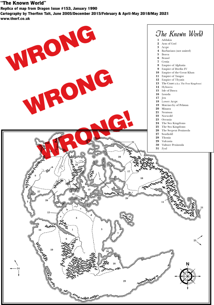
It was an embarrassingly long time before I realised that this map was a world map that the Expert map fitted into a tiny corner of. I just thought it was another map, despite the title The Known World and the legend. Mind you, I suppose it didn’t help that the Expert set map section of it was under the staple on the page fold…
23 January 2022 @ 12:13 am
The “Mountains” and “Mountain Ridge” at the southern edge of the Great Waste never really make an appearance as such later beyond ignorable hills. I think mountains there would had some nice interest.
23 January 2022 @ 12:22 am
Well remember that those are derived from the Jurassic Earth map, and whoever drew that map clearly decided not to include them on the world map. Since the Time Life book came out in 1983, I think it’s highly unlikely that X4’s Great Waste cartographer had access to either the Jurassic Earth map or the world map at that time.
In any case, in terms of the maps today, I’d love to add those to the Great Waste. As you say, it would provide some nice detail in an otherwise vast empty desert. They needn’t be as prominent as my markings suggest, either — just some uplands breaking up the monotonous desert would do it.
23 January 2022 @ 2:55 am
As you know, I think the Master Set map lends itself to at least one other reasonable interpretation, in the context of 1985. I realize that you have a valid, systematic vision for the Atlas of Mystara continuity, with a specific end-goal in mind.
Yet for history’s sake, and for the sake of research, I feel it could be good to mention that the Master Set map includes corner areas which are totally “outside” of the Mollweide projection: those corners of the Master Set map are actually areas of “outer space.”
So if the Master Set “map” is indeed interpreted as a map of land and water (rather than slices of “outer space”)—which would be a reasonable assumption!–this would necessitate that the Master Set map be interpreted in another way other than Mollweide, namely Equirectangular (a simple grid) or Mercator (as the most common projection for popular world maps in 1985).
I’m not saying that your approach isn’t reasonable. It has very reasonable parameters. I’m just saying that, in the context of 1985, there were at least two reasonable interpretations. And one of these interpretations (Equirectangular plot) was then used for the HWCS map. So there were later ramifications which could be interesting to explain now.
23 January 2022 @ 11:06 am
I alluded to this already in the article here, although somewhat obliquely. A more comprehensive look at the process of georegistering the Master Set map via the Jurassic Map is a topic for Appendix L: Lining Up Mystara. There will be plenty of space there to cover every aspect of the topic, including everything you mention.
In terms of maps, my model up until 2018 was essentially what you describe, as I was interpreting the world map as an Equirectangular projection. Those maps are still available for anyone who wishes to use that model.
However, the main revelation of the Jurassic Earth map was that a projection is mathematically “baked in” to each map, and for Mystara this projection is Mollweide. My logic of applying Equirectangular, while understandable given the presentation of the Master Set map, was flawed. This can be easily verified by looking at the map placed on a globe and seeing the landmasses deformed; in fact, this is precisely what convinced me.
So I can’t disagree that the Equirectangular approach was reasonable, as it was my own logical conclusion until 2018. But I abandoned that interpretation when I discovered its flaws, and I can’t afford to spend any more time on it.
Let’s not worry about how this affects the Hollow World Set maps, though — I will deal with that fully when it comes up in Mystara 1990.
18 September 2023 @ 7:36 pm
Totally agree on this, moreover I think the addition of high lands in this region is fitting with the Oltec / Azcan pre-Cataclymic history, with the Oltecs inhabiting “deep forests and sheltering hills” and the Azcans living in “flatlands” (see HW timeline). I guess the extra mountains could be represented with a set of plateaus, possibly not as sttep or continuous as the Atruaghin plateaux.