World Diagram
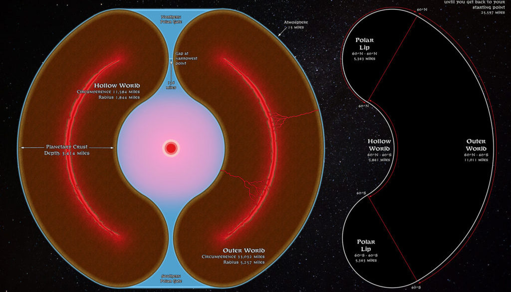
Like most worlds, Mystara has an exterior surface which faces the sun and the stars. But instead of being solid all the way to its core, the planet is hollow inside. That interior is a world of its own — a world lit by a magical sun.
Two tubular polar openings allow access from Mystara’s surface to the Hollow World. […] Two other structural peculiarities distinguish Mystara from real-world planets. Mystara’s Worldshield is a layer of super-dense molten lava within the planetary crust. It provides gravity for both the outer world and the Hollow World. Mystara’s Skyshield is a natural energy field the restrains the atmosphere to a fifteen-mile thick mantle over the outer and inner surfaces of the world.
from Poor Wizard’s Almanac II, by Ann Dupuis
Map (December 2020)
Sources
- Hollow World Campaign Set (1990) (PDF at DriveThruRPG)
- Poor Wizard’s Almanac (1992) (PDF at DriveThruRPG)
- The World of Mystara
- Poor Wizard’s Almanac II (1993) (PDF at DriveThruRPG)
- Physical Properties of Mystara
- Poor Wizard’s Almanac III (1994) (PDF at DriveThruRPG)
- Physical Properties of Mystara
Comments
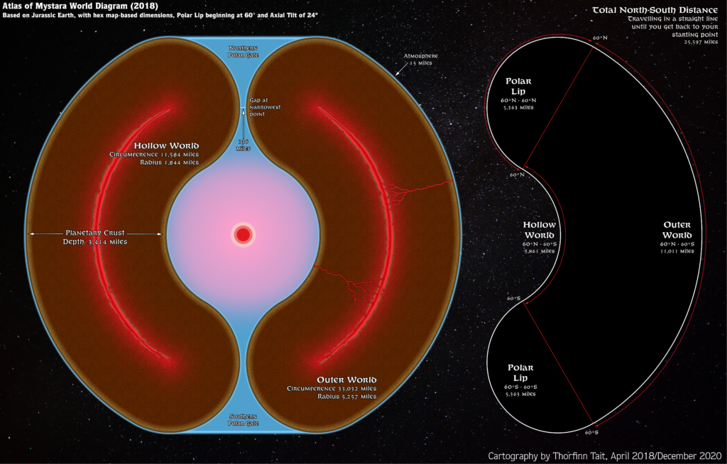
This diagram shows the latest Atlas of Mystara model of the world, originating in April 2018. The shape on the right of the image can be extruded to create a 3D model of the world, which resembles an apple in shape.
The size of the world and the exact dimensions of its polar openings has long been a subject of much contention and debate in the Mystara community. The model adopted by the Atlas emphasises the importance of the hex maps as the core of the setting, with the world scaled to fit their dimensions rather than vice versa.
There are various other, equally valid approaches, and it’s also quite easy to reinterpret this model at a different scale in order to make it match officially published world dimensions, or indeed real world dimensions. However, doing so means also rescaling the hex maps to make them fit the desired dimensions.
Notes
- Dimensions — The dimensions used in this diagram are those of the Atlas of Mystara 2018 model, which is based on measurements of updated hex maps placed on the Master Set world map, with reference to the Jurassic Earth map to provide the map projection. In this model, the world has been scaled to fit the hex mapped areas at approximately the correct scales they are marked at. The resulting planet is significantly larger than the Earth.
- Polar Openings — The polar openings are somewhat smaller in this model than the sources listed above would suggest — although in fact no published diagram was drawn to scale, so that dimensions given for polar openings in the text invariably fail to match their associated diagrams. This model’s openings are the best that could be hoped for under these conditions.
References
- Hollow World at the Vaults of Pandius
- Mapping Issues: Size of Mystara discussion thread at The Piazza
- Mapping Issues: World Dimensions discussion thread at The Piazza
Thanks to:
Michele Carpita.

