")
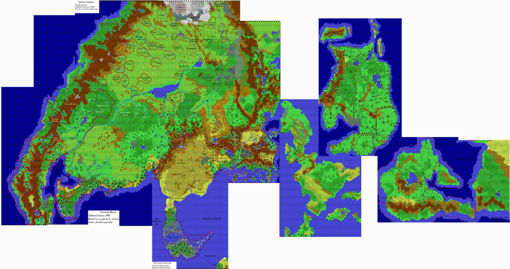
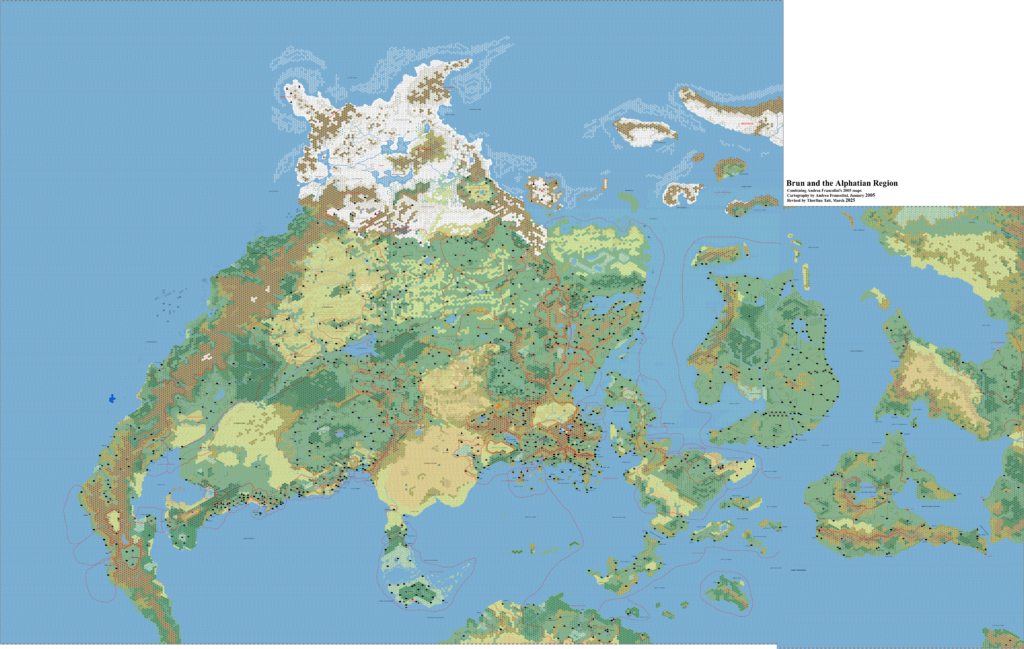
Brun, 24 miles per hex (1985)
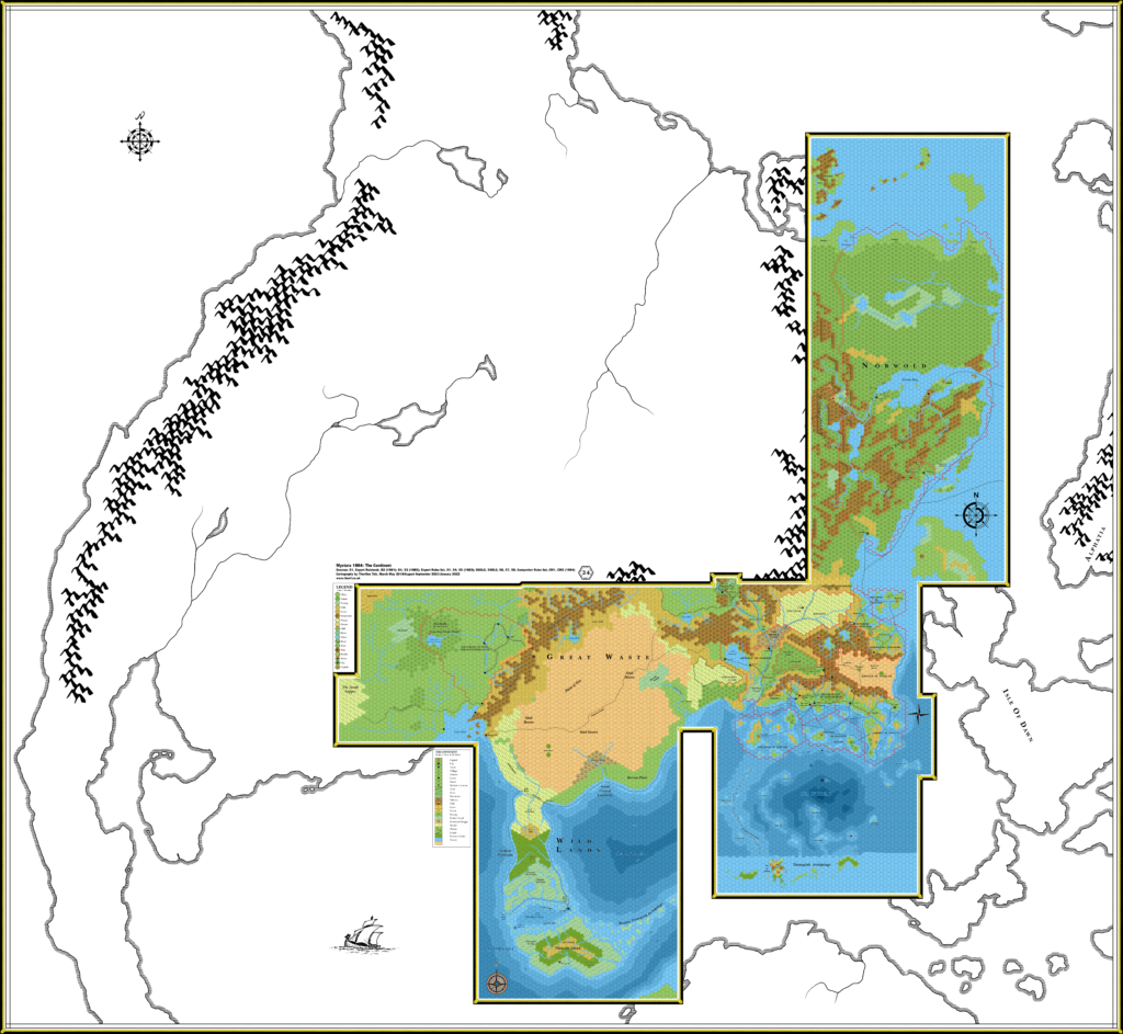
1985’s Brun map is a major expansion of the previous year’s, adding information not just from the Master Set’s world map, but also X9’s Savage Coast, M1’s Norwold & Alphatia, and the Jurassic Earth map that inspired Mystara’s geography.
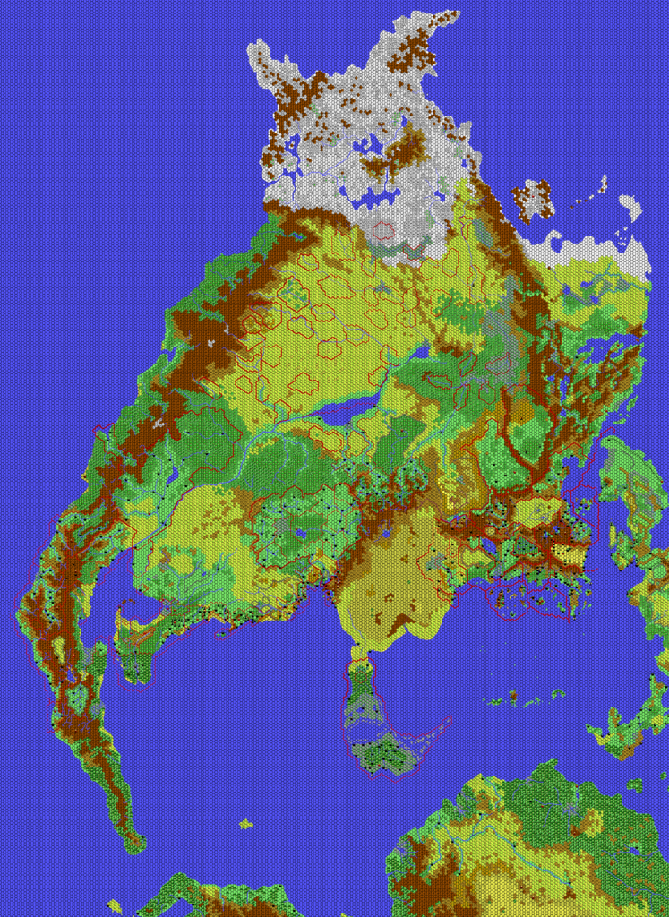
The Master Set’s primary contribution to this area was in the form of regional borders and labels, many of which appear here for the first time; everything northwest of the fully hex-mapped area was new this year. The regions are generally pretty massive, and their exact status has long puzzled fans — especially in the case of macro-regions that also appear to be nations, and none more so than the Empire of Dorfin IV. The Empire of Thyatis likewise seemed to indicate a large region, however, despite what we already knew about Thyatis and its neighbours. A reasonable conclusion to this may be that these labels indicate “sphere of influence” rather than massive single-state regions.
The Savage Coast would be the last major addition of new lands to Brun’s hex maps, as the focus soon moved to expanding existing areas after this. (Successive expansions within Brun would be relatively minor in scale: 1986’s Wendar & Denagoth, 1987’s Great Northway Lands, and 1993’s Arm of the Immortals, not to mention the addition of wider terrain types in 1989 and 1990.) X9’s map, like CM1’s Norwold, had a rather different rotation from the rest of the continent. Unlike Norwold, it also had a different scale, so for this map I have completely redrawn the area to fit this map’s contiguous 24 mile hex grid.
Much of M1’s map lay outside the edge of this map, but I have added those features that fit here. I did consider adapting the hex map to 24 mile hexes, but there wasn’t really enough detail to make it worthwhile.
Finally, the Jurassic Earth map provided details for mountain ranges as well as coastal shelves. I have added the former as brown blobs, with the dark brown indicating the shape of ridges; sometimes they coincide with mountains marked on other maps, but sometimes they don’t. For those that don’t, such as in northwestern Brun, it would be reasonable to interpret these are minor ranges — or indeed to ignore them altogether. For now I have simply left both as they came.
Since the resulting map has quite a lot more detail than it did in 1984, I have expanded the hex grid to encompass the whole continent. While future developments will add to the map, and some places will change somewhat (Alphatia and the Isle of Dawn especially come to mind), the general locations will not change. This map can therefore be considered an important base map for the Atlas of Mystara, and all future Atlas maps, Updated as well as Chronological, will build on these foundations.
Chronological Map (January 2022)
Full Resolution >>> Brun, 24 mph (1985) (300 DPI) <<< Right Click, Save
One (or more) of the maps linked to above is a lower resolution version. You can download the full size version using the following link (right click and choose “Save Link As…”).
Mobile Users: Note that it may not be possible to view the full resolution image on your device.
Full Resolution >>> Brun, 24 mph (1985) (300 DPI) <<< Right Click, Save
This map is part of the Mystara 1985 series of chronological maps. It is an updated map, incorporating all available sources and made internally consistent with other maps in its series. But it only uses sources published in or before 1985.
For more information, see Appendix C: Cartographic Chronology.
Sources
- Mystara 1984
- Master Rules Set (1985) (PDF at DriveThruRPG)
- X9 The Savage Coast (1985) (PDF at DriveThruRPG)
- X10 Red Arrow, Black Shield (1985) (PDF at DriveThruRPG)
- M1 Into the Maelstrom (1985) (PDF at DriveThruRPG)
- O2 Blade of Vengeance (1985) (PDF at DriveThruRPG)
Revisions
For detailed notes, see the posts for each individual source map at the links above.
- Depths — All depths marked outside the border of the fully mapped areas are either derived from the Jurassic Earth map, or intuited from adjacent marked depths from X6 and X7.
References
- Let’s Map Mystara 1985 — the original project thread for this map
- Let’s Map Mystara Together discussion thread at The Piazza (link leads to this map’s post)
- Brun at the Vaults of Pandius
Thanks to:
Matthew Fleet.
")
")
")
3 February 2022 @ 1:57 am
Great map — I love seeing it come together.
Since the Master Set regions aren’t officially deleted until VotPA, my personal preference is that they be shown on Updated/Chronological maps all the way till then. This is maximal information.
I personally want to know where the Southold regional line runs as it approaches Hule, and where the Serpent Peninsula region transects the Adri Varma Plateau and the Atruaghin Clans. Mentzer affirms that those regions have some in-world reality (up until Bruce’s total revision). Even if the line is made partly transparent where it crossed into hex-mapped areas.
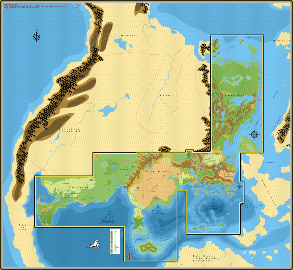
Also: I feel ambivalent about the crenulated border surrounding the hex-mapped areas. I realize that that dark border helps those areas stand out visually. But…from a “maximal information” perspective, the crenulations do obscure the areas which they cover over. Which though aesthetically justified, is less ideal from an informational perspective.
3 February 2022 @ 10:10 pm
The Master Set regions are never officially deleted at all. That is a simplification of what happened that I disagree with.
I did consider placing the Master Set borders layer above the hex art layer, but it looks messy, so I decided against it. As I mentioned in my reply to your comment on the Known World 1985 map, I have no problem with things not appearing in all the maps where it doesn’t quite fit. I’m also not going to present conflicting information, because the whole point of my project — and indeed all my projects since 2015 — is to resolve the conflicts. These borders are fully present in the continental map, where it is pretty clear how they interact with the boxes regions.
The border around the hex maps shows where the information ends — the vast majority of the stuff they’re hiding is uneven edges that were off the page of the printed maps. It would be better to consider all the surrounding art of the continent as an added bonus — and remember that the obscured areas are all visible on the separate continental map.
I do understand the desire for a map without this weird internal border, and I have considered posting a variant with it turned off — but doing so means adding another map to the already significant number I need to keep track of and update. I can’t realistically do that for every year, especially when this huge map takes a significant amount of time to export and upload.
3 February 2022 @ 2:09 am
P.S. You say: “A reasonable conclusion to this may be that these labels indicate “sphere of influence” rather than massive single-state regions.”
Rather than either/or, I’d agree if the words “some of these labels” were inserted:
“A reasonable conclusion to this may be that some of these labels indicate “sphere of influence”, while some represent massive single-state regions (such as Alphatia).”
P.P.S. I think it’s important to add M1’s 150-mi/hex map of western Alphatia to this Brun map. Without converting it to 24-mile hexes. Why can only 24-mile hexes the only granularity which can be shown on these Chronological maps? These Chronological maps show our state of official knowledge, right? Well, for western Alphatia, that M1 map is the finest granularity we have at this time…it’s our current state of knowledge in 1985.
We are missing “maximal information” if we don’t include that 150 mi/hex map. Just as there are two fields of granularity (24-mile hexed, and un-hexed Master Set/Jurassic info), there can be a third field of granularity. And it will be cool to see that “blurry granularity” transformed when later maps bring in a finer hex grid.
3 February 2022 @ 10:28 pm
It’s not at all clear which labels would represent which at this point in the setting’s history. Thyatis just gives us a useful example to show that it may not be meant entirely literally. Actually Alphatia is an interesting example in that it shows less than the full extent of the empire — even at this stage we already know that part of the Isle of Dawn belongs to Alphatia, but there’s no arrow there. Nor to Esterhold, which is bordered off but lacking any label.
In any case, my comment here was referring primarily to the two Empire labels I included on this map: Empire of Thyatis and Empire of Dorfin IV. The latter of these is the most problematic of all Master Set labels, as its region is vast, and includes Hule. On the other hand, the label is strangely not at all centred, unlike most other Master Set map labels. Combine this with the example of Thyatis, and it seems there are multiple good reasons not to take Dorfin IV’s empire as encompassing that whole region.
It doesn’t really matter, because of course we never got any more reliable positive information about the Empire of Dorfin IV. So the interpretation is up to each individual looking at the maps.
I probably shouldn’t have the label going east of the river, but I don’t want it to overlap with the Jurassic Earth map’s mountains, which make it harder to see.
About M1’s map… I’m not adding 138 mile hexes to the 24 mile per hex map, no. You seem to be overlooking the existence of Norwold & Alphatia, 138 miles per hex (1985). I have added what could be added from that map, short of converting it to 24 miles per hex, which is probably a step too far. Again, I don’t share your goal of maximal information in one particular map; I’m quite happy to have bits and pieces throughout the maps where it makes sense to do this.