Thorf's Secret Project: Stage One
A recreation of the Mystara Message Board thread that started the Atlas of Mystara project, with restored links and images.

30 March 2005, 06:17 AM
|
|
Member
|
|
Join Date: Mar 2001
Location: Twin Cities, MN
|
|
Quote:
|
Originally Posted by Thorf
Good
catch! Although it does bring up the question of how exactly that hex
is different from regular mountain hexes, since a single normal
mountain hex in the middle of plains or other terrain also seems to
indicate a single mountain.
|
I figured that it was the Mystara equivalent of the Rock of Gibraltar.
Regards,
Eric Anondson
|
30 March 2005, 08:21 AM
|
 |
Member
|
|
Join Date: Mar 2004
Location: Ontario, Canada
|
|
Quote:
|
Originally Posted by Thorf
On
the other hand, I do wonder about the value of the 72 mile per hex
scale. It seems to me that it is far too large a scale to provide
anything but the most general terrain information - especially when it
comes to areas like the Known World and the Savage Coast, which have
numerous small countries.
|
That's a good idea! Have the large scale map be a political map instead of a geographic map.
I've had a long-time dream of drawing an altitude map. As a matter of
fact I've started one on several occasions but never (for some reason
or other) been able to finish it.
My computer mapping skills are rather, well, non-existant! But I have
hand-drawn two maps so far for my players in the style of the ones that
appear in The Lord of the Rings
movies; one is of the Known World and one is of the Northern Reaches.
They are used as the maps that the characters actually have in-game.
|
30 March 2005, 08:48 AM
|
|
|
Quote:
|
Originally Posted by Hugin
That's a good idea! Have the large scale map be a political map instead of a geographic map.
|
Yep, thats what I've been using it as, but I've also found it useful
for relative geographic positioning of the various land masses.
Quote:
|
Originally Posted by Hugin
I've
had a long-time dream of drawing an altitude map. As a matter of fact
I've started one on several occasions but never (for some reason or
other) been able to finish it.
|
I tried this once, but found too many inconsistencies to be able to make it work (notably the Streel River system).
|
30 March 2005, 09:08 AM
|
|
Member
|
|
Join Date: Mar 2004
Location: Ontario, Canada
|
|
Quote:
|
Originally Posted by mah9
I tried this once, but found too many inconsistencies to be able to make it work (notably the Streel River system).
|
I remember having trouble with the Streel as well. IIRC, the problem pops its head up around the Broken Lands.
Yep! In the AC 1011 Almanac, both Corunglain and Ethengar have
altitudes of 1800 feet. Even assuming that there is some varience in
those general numbers, that's not much of a slope for the river to
follow. Besides that, gaz 10 shows several greater cataracts along the Streel in the Broken Lands.
|
30 March 2005, 09:11 AM
|
 |
Member
|
|
|
|
O
man the Streel river system is a geographical nightmare and could only
exist in a world that was "shaped by the Immortals". I too started to
do topographical maps but gave that up almost immediately after I took
a look at the Streel.
|
30 March 2005, 10:58 AM
|
 |
Member
|
|
Join Date: Jan 2005
Location: Akita, Japan
|
|
 Wednesday's Map
Here's today's map. We're staying on the Savage Coast for the next few days, it seems. 
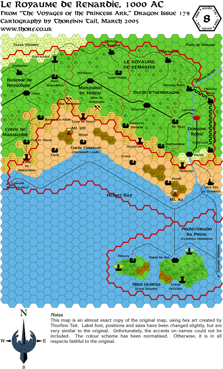
By the way, in case you're wondering if I'm ever going to be completing these maps, the answer is yes. 
Reproducing the Dragon maps is merely the first step, and provides the
basis for what will eventually be the fully updated and expanded maps.
Of course that's always the case with my project, but in the case of
the Savage Coast, there's an additional problem in that one of the
primary sources is the large non-hex poster maps from the Red Steel
sets. This has caused me problems up until now, but someone was able to
provide me with some additional scans, which have allowed me to
reassemble the scans from the Red Steel PDF with much more precision.
(You know who you are, and thanks again! )
|
30 March 2005, 11:15 AM
|
|
Member
|
|
Join Date: Jan 2005
Location: Akita, Japan
|
|
 I just remembered...
I
need to ask a favour. Is there anyone here who has access to the
original Dragon magazines with the Princess Ark maps? On the scans that
I have, from the Dragon Archive CDs and from Thibault's site, it's very
hard to make out if there should be any reefs along the coast.
Specifically, I'm talking about the region from Robrenn (issue 177) all
the way along to the Arm of the Immortals (issue 200).
I suspect that there are a few areas of reefs, but I'd really like to
get it confirmed, and unfortunately my copies of the magazines are
about 6000 miles away right now.
If someone is able to confirm this for me, the best thing to do would
be to grab the scans from Thibault's site and mark the hexes with
reefs. Just scribbling on the map in Paint would do it. Then e-mail the
scan to me at thorf13@hotmail.com.
As we say here in Japan, yoroshiku ne!
|
30 March 2005, 04:00 PM
|
|
Member
|
|
Join Date: Mar 2001
Location: Twin Cities, MN
|
|
Quote:
|
Originally Posted by Thorf
Is there anyone here who has access to the original Dragon magazines with the Princess Ark maps?
|
I have the issue, but boxed so deep I couldn't get to it without
rearranging my entire office. I've been going off of the Princess Arc
scans as well. 
BTW, looking at the Princess Arc maps of the Savage Coast, the
deciduous forested hills have a the same background green as the heavy
deciduous forest, rather than the same background green as light
deciduous forest and farmland. You may have addressed this earlier, but
was it a design choice to go with the forest deciduous hills to use the
same background green as farmland?
Regards,
Eric Anondson
|
30 March 2005, 04:28 PM
|
 |
Member
|
|
Join Date: Apr 2004
Location: Andover, United Kingdom
|
|
I hope someone more competent does the reefs, but in case they don't I will try to dig them out tonight
As for altitude maps and silly rivers, one can cheat! (And so can the
rivers). If you need a river to flow across a mountain range from the
low ground to the low ground it can! I think it is the Ganges which
flows straight through the Himalayas - the river is older than the
mountains and carved its gorge as the mountains rose...
Of course this won't work for the broken lands, as iirc they were the
product of a Blackmoor device going BANG, but there are two tricks we
could use:
1) The broken lands have messed up gravity as well as the magic and physical world got REALLY scrambled.
2) Have western Darokin at a much lower altitude c.f. Alfheim and
Ethengar - making them both high plateaus (which fits the description
of Alfheim before the elves arrived quite well). There would be a
gradual but definite slope down from Alfheim to the Streel river valley.
I prefer idea 2 (though I think 1 has potential) and it does not mess
up any other geography as the rest of eastern Darokin is surounded by
hills and mountains, as is Ethengar (make that the Ethengar plateau) -
the hills seperating it from Vestland and Heldann not being so much a
barrier but the edge of the plateau...
Of course the actual river connections as drawn are a problem, but I am
sure we can tackle them eventually. One point though, in England all
our rivers are much smaller, but two significant ones (for us) are the
Severn and the Wye, both reach the sea at the same place (ish) and
their sources are (iirc) a mile and a half apart, they just take very
different routes. I wonder how they would look on an 8-mile hex map
scale? Also just to show that nature can lay silly games too, their
sources are about 10 miles east of the sea, but the Wye flows
south-east and the Severn north-east (the Severn is the longest river
in England)...
__________________
"If it looks like a duck and quacks like a duck it might just be a crow."
|
30 March 2005, 04:29 PM
|
 |
Member
|
|
Join Date: Apr 2004
Location: Long Beach, CA
|
|
Quote:
|
Originally Posted by Thorf
I
suspect that there are a few areas of reefs, but I'd really like to get
it confirmed, and unfortunately my copies of the magazines are about
6000 miles away right now.
|
There are some, but unfortunately the coloring makes it really hard to
see. I'll try to do the scan/paint thing you suggest and send them
along to you tonight.
[EDIT] Actually, I just compared the originals with
Adamantyr/Ironwolf's maps on Thibault's site, and he's got them marked
exactly as they are on the Dragon maps, so you could just use those as
your template and they'd match up.
Last edited by Cthulhudrew : 03-30-05 at 04:34 PM.
|
30 March 2005, 06:16 PM
|
|
Member
|
|
Join Date: Jan 2005
Location: Akita, Japan
|
|
Oh, I had forgotten Adamantyr's maps.   Thanks for reminding me, I'll use them to add in the missing reefs.
Just to chip in to the ongoing contour map discussion - personally I
don't think the problems are insurmountable. Altitude information for
each country and each area is not especially common, and even where it
is provided it's usually just average figures. This leaves us
cartographers with a lot of latitude to make things work, regardless of
how they are portrayed on the map.
Eventually, if no one beats me to it, I'll probably have a go at a
countour map. It would be quite fun to do, I think, and of course it
would be relatively easy to use the coastlines, rivers and such from
the hex map files, so the "only" thing that would need to be done would
be the actual contours...
|
31 March 2005, 12:40 AM
|
|
|
Maps
Quote:
|
Originally Posted by Cthulhudrew
Actually,
I just compared the originals with Adamantyr/Ironwolf's maps on
Thibault's site, and he's got them marked exactly as they are on the
Dragon maps, so you could just use those as your template and they'd
match up.
|
Yes, I used the original magazines as my templates. Quite welcome!
Adamantyr
|
31 March 2005, 01:39 AM
|
|
Member
|
|
|
|
Don't
get me wrong, I don't think a contour map is impossible, just alot more
work than I was prepared to do. There are a few places that get wierd.
Start in Rockhome. The Evemur river starts within sight of steppelands
and instead flows through the mountains to a lake. This means that NW
Ylaruam and southern Rockhome is the highest altitude. Until the
Nithian River was diverted the other way and the Ylari Highlands in the
north were raised, the Styrdal would not have cut through the north
into Ethengar. The only feed for that river system would then be the
Hrap which flows from Lake Klintest. Now, Ive seen alot of Mystara maps
which show The Klintest river running through Vestland, and the same
goes for the Vestfjord which is shown to start in the same lake. If
this is the case then no way could the Hrap exist.
If the rivers are to spill over and cut their way through the mountains
to the east to flow across a coastal highland and cut fjords into it to
the sea then the coastal highlands would have to be considerably lower
than the lake. The steppes in which the Hrap flows would have to be
higher in elev. than the highlands, because of the long gradual decline
of the river system, so east Ethengar would have to continue rising to
the coast. Now we have 2 short fast rivers running downhill quickly in
the east and this would prevent any other river from cutting a slower
path into the north.
It's amazing with three rivers flowing from it that there is a lake
left at all. The mere fact that there is not one but two in the region
suggests a tremendous amount of rainfall. How does that occur in a high
altitude mountain range smack between steppes and a desert?
Next we are into Ethengar. As it turns out there is yet another
tributary supplying this system from eastern Ethengar, suggesting again
that it raises up in the east. The hills then would be hills and not
the "edge of the plateau". (the cliffs along this coast must be
magnificent) The Krandai joins the Hrap and the Styrdal at a small lake
in a depression in the steppes. I don't know about anyone else but to
me it is very hard to reconcile the flow of these rivers through and
around these depressions. The two rivers that give me the least trouble
are the central river (which appears to be the headwaters of the
Streel), although it runs within sight of a depression, and the
Dol-Anur. These rivers travel through a region that doesnt see a huge
amount of rainfall so can't be especially big or strong rivers. And
remember until Nithia is destroyed the Styrdal probably didn't exist. I
would make this same arguement for the Hrap as well. So we have an
unexceptional amount of water flowing into the west.
It all seems to flow into a swamp, although if I were to guess I'd say
that originally it might have been a small lake before it made it's
push through the mountains. As to where this lake drained I don't know.
I believe it would have taken alot of water and force to push through
the mountains, so either this lake was huge (kinda contradictory to the
amount of water available) or everything happened when Nithia fell and
the Rockhome Lakes added their water to the system (I know this concept
is not supported anywhere in the material but it is the logical
conclusion of my research) So when it finally cut its way through the
mountains the lake drained off and became a swamp. This doesn't make
much sense either but that's what happened.
This suggests that the broken lands are not so much mountains but the
"edge of the plateau". A wierd little zit between three mountain ranges
broken asunder by magical blasts and the relentlessness of the rivers.
Then we come to Darokin. Everything here is pretty simple. I would like
to suggest, however, that the river which has always flowed through
here is the Vesubia River. It would have been the more direct flow from
the Glantrian highlands and mountains. It wouldn't have been untill
after the Fall of Nithia and the swamp/lake draining that the Streel in
Ethengar joined the Vesubia.
As I said this was all too much headache for me. Not that the history
had much bearance on a current map but I wanted to get an idea of how
it all happened. There is still a lot of headache trying to get the
elevations right for every area. If you can do it I say more power to
you! I'll be patiently waiting (and drooling) for it.
|
31 March 2005, 04:44 AM
|
|
Member
|
|
Join Date: Mar 2001
Location: Twin Cities, MN
|
|
I've had issues with reconciling irregularities with the maps as well. I've worked through most of them though.
Quote:
|
Originally Posted by Malteen
Start
in Rockhome. The Evemur river starts within sight of steppelands and
instead flows through the mountains to a lake. This means that NW
Ylaruam and southern Rockhome is the highest altitude.
It doesn't mean they are the same altitude. There is still 8 miles of
mountains between the river and the steppes of Makistan. A huge amount
of elevation change can occur in 8 miles.
[QUOTE=Malteen]Until the Nithian River was diverted the other way and
the Ylari Highlands in the north were raised, the Styrdal would not
have cut through the north into Ethengar.
|
Emirates of Ylaruam (Gaz 2) only tells us that there was "an
uplift of the northern Alasiiyan plateau and a subsidence of the
centrao Alasiyan desert. The headwaters of the great River Nithia were
diverted through what is now the Makistani Plateau, finally
disappearing into the great subterranean reservoirs of the Alasiyan
drainage."
What this tells us is that the Emirate of Makistan is of lower
elevation than northwest Alasiya today. And it is Makistan that borders
Rockhome, near the headwaters of the Evemur. I would argue that the old
River Nithia had its headwaters in the Makres Mountains, southwest of
the Makres River.
Since the Makistan Plateau never changed in elevation there never would
have been a geologic change to redirect the outflow of Lake Stahl.
Quote:
|
Originally Posted by Malteen
If
the rivers are to spill over and cut their way through the mountains to
the east to flow across a coastal highland and cut fjords into it to
the sea then the coastal highlands would have to be considerably lower
than the lake.
|
Rivers do not cut fjords. Glaciers do. It is very likely that with the
geologically recent glaciation that buried the area after Blackmoor
that the river valleys in which the Vestfjord, Klintest, and Hrap river
were all carved by glaciers.
River erosion occurs at different speeds depending on the angle. Volume
doesn't have as much to do with it as angle of flow. The steeper the
flow, the faster the river, the faster the erosion
Quote:
|
Originally Posted by Malteen
The
steppes in which the Hrap flows would have to be higher in elev. than
the highlands, because of the long gradual decline of the river system,
so east Ethengar would have to continue rising to the coast. Now we
have 2 short fast rivers running downhill quickly in the east and this
would prevent any other river from cutting a slower path into the
north.
|
We could assume that the Vestfjord and Klintest are short and fast, but
all we know is that they share the same elevation of headwaters as the
Hrap. We don't know what elevation it is. For all we know, the Hrap is
also a short fast river until it hits the Ethengar steppes. We do know
that the Vestfjord and Klintest/(Landersfjord?) rivers are
"swiftflowing, rocky and treacherous" (Gaz 7) past Rhoona on the
Vestfjord River and Landersfjord on the Klintest River.
Dwarves of Rockhome says that the Kur River is a "mountain
stream" as it flows from Lake Klintest and "flows northeast in a series
of rapids." But we don't know when those rapids begin. For all we know
the rapids begin 16 miles from the shore of Lake Klintest, and the Kur
River flows as a peacefully calm stream until the rapids.
Gaz does say about the Klintest River that "(t)his river forms in Lake
Klintest and flows east into a gorge in the Makres Mountains." It's
almost 50 miles to the Makres Mountains and the Klintest River could be
a gentle river until he falls into the gorge in the mountain... but who
know where that gorge is in the Makres?
Quote:
|
Originally Posted by Malteen
It's
amazing with three rivers flowing from it that there is a lake left at
all. The mere fact that there is not one but two in the region suggests
a tremendous amount of rainfall. How does that occur in a high altitude
mountain range smack between steppes and a desert?
|
It is amazing that two small rivers and one stream flow
from the lake. It is exceedingly rare. But that there are lakes this
size tells us nothing about the rainfall. Lake Baikal in Siberia is
crammed into the mountains, but there is little rainfall there. The
Great Lakes of North America don't get that much rainfall, compared to
the Ohio River valley just to the south.
Quote:
|
Originally Posted by Malteen
The
Krandai joins the Hrap and the Styrdal at a small lake in a depression
in the steppes. I don't know about anyone else but to me it is very
hard to reconcile the flow of these rivers through and around these
depressions.
|
Yeah, I have the same problems... Well, rather I have problems
reconciling the closed depression of the Sea of Flowers. The best I can
come with is that the soil there is extremely permiable and a matrix of
caverns exist beneath the surface and what little rain there is that
falls onto the area doesn't so much as flow across the steppe, but
soaks into the ground and seeps into the caves beneath the surface.
Possibly beneath the Sea of Flowers is the worlds largest limestone
cave network that has begun to collapse like a sinkhole in slow motion.
(shrug)
Quote:
|
Originally Posted by Malteen
And remember until Nithia is destroyed the Styrdal probably didn't exist.
|
I disagree (see above).
Quote:
|
Originally Posted by Malteen
So we have an unexceptional amount of water flowing into the west.
|
Not necessarily. For example, looking at the Mississippi river basin.
Looking at the juncture of the Ohio River basin with the rest of the
Upper Mississippi River Basin and
the Missouri River Basin you might think that most of the water there
comes from the Mississippi flow. But it doesn't. At that junction, the
Ohio River contributes 2/3rds more water to the flow than the
Mississippi River brings. The Ohio River Basin is tiny in comparison to
the Mississippi/Missouri River basin. It's all in the rainfall, and we
can't judge how much rain there is by the size of the lakes.
And the Streel flowing through the Broken Lands. I'd put greater faith
that it is flowing through a glacially carved valley. There is no
reason a river would have carved through mountains when it would have
just redirected towards the lower elevation of the Black Hills. To me,
this means that there was already a carved valley through the mountains
there. And glaciation is the best cause.
Just some thoughts from a geographer for you.
Regards,
Eric Anondson
|
31 March 2005, 10:24 AM
|
|
Member
|
|
|
|
The
map I have (the original) shows Evemur as begiining in the steppes, not
8 miles away. The river Nithia is clearly marked, there should be no
guessing.
Makistan is not marked as a plateau regardless of the description. It
does not show elev lines (although the "plateaus" of Mystara more
resemble mesas) If the river Nithia flows south into a mountain pool it
makes it harder to reconcile with the tributary and Lake Stahl.
Makistan on my map IS NW Alasiya, it doesnt get anymore north or west
from here. A subsidence is a lowering, so Makistan is higher than the
central deserts. I'd agree that Makistan would apparently have been cut
out by a river but the only river in the area is the Evemur. I already
understood erosion and the speed of rivers. Water follows the path of
least resistance. That was my point. Volume has everything to do with
the size of the system itself, the ability to flow "up" out of a
depression, and cutting through the mountains. I would suggest here
that what forms the badlands and brokenlands in the Broken Lands is the
2 rivers flooding out and carving the rock into a maze of gorges and
ravines etc. hence my assumption of alot of water needed.
I have lived in Ohio most of my life and I can tell you, you are not
entirely correct about the Great Lakes. They are created from rivers
from Canada which recieves alot more precipitation than the Ohio
valley. In fact almost all of our weather comes from the NW in Canada.
It releases alot of precipitation in Canada feeding the lakes and
rivers there. Travels across the Great Lakes, picking up more moisture,
to drop it on the land in an increasing amount the closer to the
mountains it gets.Its called the lake effect. Thats why the lakes
themselves don't seem to get alot of rainfall, but a lake doesn't feed
itself. The reason the Ohio valley gets as much rain as it does is
because the weather "breaks" on the Appalachians. There is a tremendous
amount of water involved in the Ohio and Mississippi drainage systems
and only this much water can make rivers this big. A comparison between
the Streel and the Mississippi wouldnt be farfetched, but now you have
to combine all the rainfall throughout the entire Ohio, Missouri, and
Mississippi systems into Rockhome with a little for Ethengar. Not
forgetting Glantri, but the Streel is still rather large in Ethengar.
It is apparent that Ethengar does not recieve alot of precipitation yet
has a few fairly large rivers. Typically the weather would "break"
against the sides of the mountains not in them. Meaning the areas
around Rockhome should see more rainfall. This is not the case. Having
said that and using your arguement that the lakes in Rockhome do not
denote alot of rainfall I wonder how with an unexceptional amount of
water we are getting a Mississippi river, and a flood big enough to
carve out the brokenlands. The weather systems on Mystara are highly
more questionable than the geography, but this doesn't make the
geography any easier.
I still dont see how to reconcile a lake that flows in two different
directions. Especially the one that has two short outlets to the sea
and one long one in a totally different direction. This is also why I
refuse to believe that the Styrdal and the Nithia existed at the same
time. IMC I turn the Nithia around to have it flow into the Stahl
(which is actually how it is pictured in the map) I consider this as
diverting the headwaters from flowing into Ylaruam.
While the geography is reconcilable for the most part it still remains
to be seen how to do a contour. I think if you started in on one youd
see that its not as easy as it sounds to reconcile this stuff.
PS>don't pay too much attention to what the Rockhome GAZ says, one
column before the one you quoted from has all the rivers flowing into
the lakes, including the Hrap, Kur, Styrdal, and Klintest. And thats
not the only obvious error.
|
31 March 2005, 10:51 AM
|
|
Member
|
|
Join Date: Dec 2003
Location: Jacksonville, FL
|
|
Don't wrack your brains too much, guys. Remember that this is a fantasy
world. It doesn't have to make sense. Anything that contradicts
meteorology or geology can easily be explained by magic, if nothing
else.
For example: the magically controlled weather in Alfheim is an easy
explanation as any for almost any meteorological inconsistencies in the
entire Known World region.
So you've got a lake that shouldn't be there? Fine. A gate to the Elemental Plane of Water solves that.
Don't get so hung up on how things work in the real world - after all,
isn't the real world what we're trying to leave behind when we play?
Next we'll be discussing how improbable it is for dragons to fly …
__________________
Obligatory non sequitur goes here.
|
31 March 2005, 12:05 PM
|
|
Member
|
|
Join Date: Mar 2001
Location: Twin Cities, MN
|
|
Quote:
|
Originally Posted by Malteen
The
map I have (the original) shows Evemur as begiining in the steppes, not
8 miles away. The river Nithia is clearly marked, there should be no
guessing.
|
What original is this? The foldout map from Emirates of Ylaruam and the
Trail Map show Evenmur in a hex 8 miles away. Which map shows the River
Nithia clearly marked?
Quote:
|
Originally Posted by Malteen
Makistan is not marked as a plateau regardless of the description.
|
And neither is any part of Alasiya, but it is described as a plateau as well.
Quote:
|
Originally Posted by Malteen
Makistan on my map IS NW Alasiya, it doesnt get anymore north or west from here.
|
The fold out map of the Emirate of Ylaruam distinguishes the Emirate of
Alasiya from the Emirate of Makistan. There is an internal border line
running roughly northeast to southwest in direction.
I'm going to duck out of the climate talk, as much as there are
misconceptions I'd like to correct. It's way off the thread topic.
|
31 March 2005, 07:36 PM
|
|
Member
|
|
Join Date: Jan 2005
Location: Akita, Japan
|
|
At my mother in law's house again tonight, so no progress on mapping today or tomorrow. 
Anyway, here's today's map. When I get home tomorrow I'll be uploading
a slightly updated version of this one and the past three, with the
reefs marked in and a few minor problems fixed. Tomorrow's map will
likely be the joined together version of the last four.
I've actually been having some problems with linking up the Gulf of
Hule map with the Bellayne to Robrenn map. Specifically, the Red Steel
maps for these areas don't seem to agree with the Princess Ark maps if
overlapped as pictured on the maps. But more of that later.
|
31 March 2005, 11:07 PM
|
|
Member
|
|
|
|
Since
we were talking about the lakes in Rockhome try that map. You'll find
the Evemur where I said it is. You'll also find the Nithia River
clearly marked.
You cannot use Alfheim as the catalyst for all the known world's
meteorological wierdness since the magic the elves use is resitricted
solely to the Canolbarth.
I believe they were using the term Alasiyah as the name of the entire
region before it became Ylaruam. It is also the name of the desert
itself. They were not specifically referring to a single emirate, as
that emirate didn't exist. So, yes, there are several places in
Alasiyah described as a plateau, which can be seen by elev lines, in
the north, south, and west. I again reiterate that in this world with
these maps if it doesn't have elev lines it is not a plateau regardless
of how it is described. Even by your own descrption it cannot possibly
be a plateau if it is lower than the surrounding region.
I am not really worried about the RW science of it all as there are
immortals to make things wierd. I do, however, believe the immortals
would try to rely upon the physical laws of nature as much as possible.
Tweaking them here and there to suit there needs.
Originally I was posting about contour maps. It's all good and well to
sit there and say "It's easily reconcilable". I have actually tried
this years ago and it's not that easy.
|
1 April 2005, 05:18 AM
|
|
Member
|
|
Join Date: Dec 2003
Location: Jacksonville, FL
|
|
Quote:
|
Originally Posted by Malteen
… the magic the elves use is resitricted solely to the Canolbarth.
|
Actually, that's not quite true. The magic that sustains the Canolbarth
diverts rain from the Alasiyan basin. So the magic affects both Alfheim
and Ylaruam, in the official source material. Is it really so difficult
to imagine that magic powerful enough to alter the weather patterns of
those two places so drastically - on a nightly basis - might have had minor, unintentional side effects in neighboring countries?
I'm not really picking on any one person in particlar here. The
situation just amuses me. We can readily accept that pointy-eared
humanoids can magically manipulate the very climate of their kingdom
without question. But we have to pull out the science books to explain
a lake in the mountains (or a river's headwaters, or whatever)? 
Great job on the maps Thorf - geographically accurate or not.
|
1 April 2005, 04:11 PM
|
|
Member
|
|
Join Date: Jan 2005
Location: Akita, Japan
|
|
 Just a quick note
Today's map will be posted when I get back tonight (in about six or seven hours, probably).
I've been thinking about my current situation, and how busy I'm getting
with wedding preparations and such. When my work starts up again things
are going to get even busier, and it looks like my dad will be coming
out to visit for about a month, from mid April to mid May. On top of
that I have to look into moving apartments, and various other things.
All these things are leaning heavily on my map making capabilities, but I don't want to lose my momentum entirely. So, for now I've decided to stop posting maps at weekends.
It seems to me that there are less posts to these boards and the list
at the weekend, and the two day break from posting could allow me to
get ahead in my mapmaking, so that I have a few maps in reserve for
days when I'm busy.
Sorry to be the bearer of bad news, but I think in the end five days a week is more realistic, and much more doable.
|
1 April 2005, 10:05 PM
|
|
|
Thorf, I see you're up to the map from Dragon 180, but there doesn't seem to be a map from issues 170 or 173.
Was that because the adventures in those issues took place in an existing area?
Or did they skip a couple of issues for some reason?
BTW - I think it's a good idea about taking a break from posting maps
over the weekends. The last thing you want is to have a conflict with
the wedding plans, or things could turn a bit nasty!
|
1 April 2005, 10:13 PM
|
|
|
On the subject of river flow, I've just been reading GAZ3, and it mentions the fact that the canals of Glantri City run into the rivers, rather than the other way around.
It attributes this to a member of the Guild of Architects opening up
several small portals to the Plane of Water in various locations in the
canal system.
If a human architect can manage that, then a portal set deep within a
mountaintop lake seems like a suitable solution to at least some of the
river system problems (not that I managed to follow all of the
technical discussion! )
Then you'd just have to decide whether these were "naturally" occuring,
or if they had been placed deliberately by an Immortal or powerful
mage, and then work out why.
|
1 April 2005, 11:35 PM
|
|
Member
|
|
Join Date: Jan 2005
Location: Akita, Japan
|
|
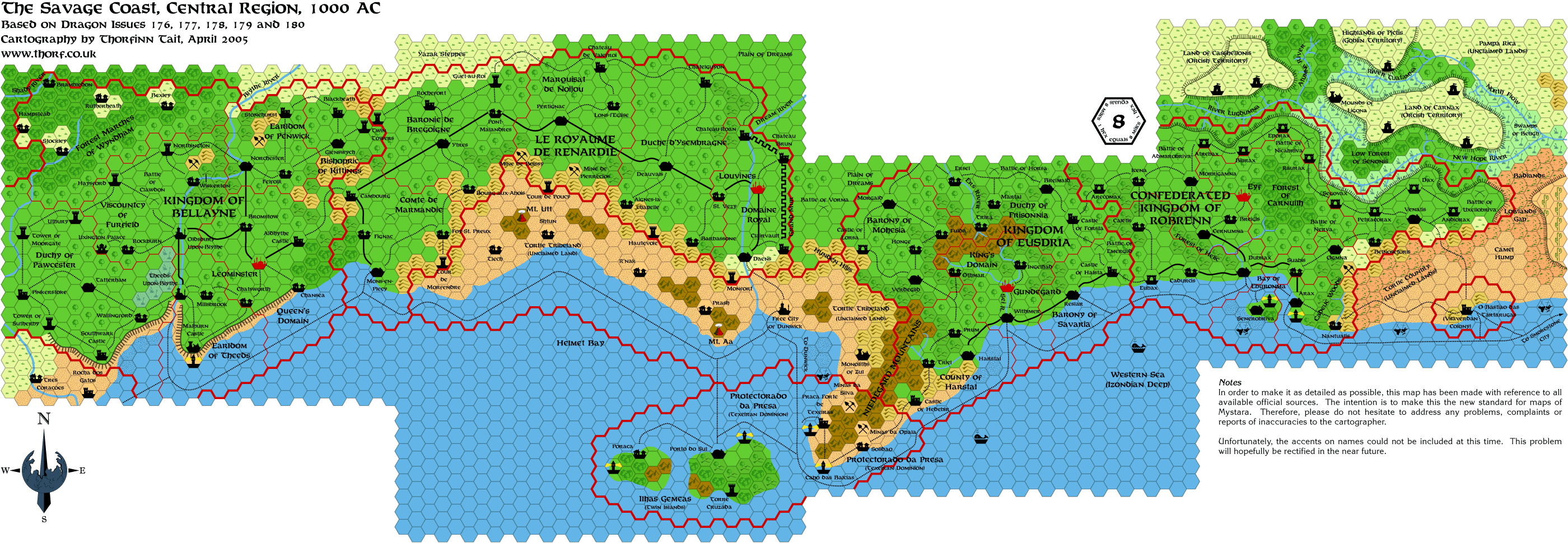
Friday's Map
Today's map is the joined up version of the last four, which together depict the central area of the Savage Coast.
It's this map that I am working on enhancing with the information from the Red Steel maps, but the finished version
will not be ready for a while yet.
|
2 April 2005, 12:37 AM
|
|
Member
|
|
|
|
I
don't have a problem with magic being the answer. If you will recall I
was the one who said the Streel "could only have been made by the
immortals" as real science doesn't fit. However, it seems to be a bad
habit of everyone, including the devs, that when something doesn't fit
throw magic at it. The idea of setting up natural patterns for things
is so they can run smoothly without constant supervision. If the lakes
had their source in the elemental plane of water there would be more
reports of monsters in those lakes, as there are in the Glantri canals.
A gate is a two-way street.
I realize that it says in the GAZs that elven magic diverts weather
from Ylaruam. I ask you though, what weather? It was a desert long
before the elves came. It would be more logical to pull weather from
the coast or from central and west Darokin. If we look at the maps, and
take into account the Canolbarth was originally steppes, it is apparent
that the entire region is a bit deficient in the rainfall dept. From
Hule to Rockhome is mostly deserts and steppes, with the exception of
Atruaghin territories, coastal lands, Lake Akesoli region, and Glantri.
Then with Ethengar and Ylaruam the majority of the known world is a
rather dry place. Not devoid of rain just not that abundant. BTW when I
said the magic was restricted to the Canolbarth I was talking about the
effect (ie. rain) not the source.
I have a pretty good idea how the lakes were made. That isn't my
problem. It's how they are still here with each one having outlets that
flows in two different directions and very little rain to replenish
them (or there is alot of rain that drops here and nowhere else. take
your pick of problems)The Streel system and the Krandai system are
large rivers not small streams. It even states in the Rockhome GAZ that
the lowlands are very fertile and see "a good amount of rainfall" and
that the region is "well-irrigated" by streams and rivers. This is
telling me that this region sees more rainfall than all the surrounding
regions (maybe even combined). We haven't even begun to mention the
caves and all the underground waterways yet.
You can throw magic at it if you want. It's the easy way out. Just
remember, every time you throw magic at something it becomes
susceptible to the day/week with no magic (whichever you use). IMC I
prefer to have a natural law explain things when possible and am loathe
to throw yet more magic at it. During the times of no magic all
non-immortal magic simply doesnt work. I make no exceptions, not even
for those things done while on a path to immortality (ie. Floating Ar,
although some have argued before that once achieving immortlity he
could've strengthened it with immortal magics). I make no exceptions
for immortals in mortal form either(Etienne, even though he would still
have access to immortal magic he can't use it on Mystara).
But these are my opinions on things. If you don't like them don't use
them. It doesn't bother me one bit. I am just trying to work through
inconsistencies without throwing yet another mage at it. There is no
reason why anyone would do anything for themselves if they could just
rely on a mage to do it for them. With that mindset I would be
surprised if Mystara wasn't full of fat, lazy people waiting for the
next peddler-mage to come a'calling. It then becomes a larger headache
for me to try and figure out how everything still works when there is
no magic. Besides, who wants to be "Immortal Peon of Rain-Making in
Rockhome" spending the majority of your immortal life (and power) on
that one thing? If anyone wants to volunteer the position is open in my
world.
|
2 April 2005, 05:59 AM
|
|
|
Quote:
|
Originally Posted by Malteen
I
realize that it says in the GAZs that elven magic diverts weather from
Ylaruam. I ask you though, what weather? It was a desert long before
the elves came. It would be more logical to pull weather from the coast
or from central and west Darokin. If we look at the maps, and take into
account the Canolbarth was originally steppes, it is apparent that the
entire region is a bit deficient in the rainfall dept. From Hule to
Rockhome is mostly deserts and steppes, with the exception of Atruaghin
territories, coastal lands, Lake Akesoli region, and Glantri. Then with
Ethengar and Ylaruam the majority of the known world is a rather dry
place. Not devoid of rain just not that abundant. BTW when I said the
magic was restricted to the Canolbarth I was talking about the effect
(ie. rain) not the source.
|
According to GAZ5, the Elves arrived in Alfheim around 800BC, and
started the weather magics which diverted rainfall from the
Alaysian/Nithian basin. This process was (IIRC) then enhanced by the
change in the lay of the land (and other Immortal magics) around that
river basin. It is also probable that some rainfall was diverted from
Ethengar making it less fertile than when the Ethangar arrived there.
As for the probable lack of rain over Rockhome, when Kagyar created
this nation, couldn't he have put in a couple of one way gates to the
Plane of Water under these lakes? Thus enabling the Dwarfs to create at
least a partial arable economy (even if it is a touch difficult for
them to come to terms with it)? There is a mention of water spirits in
GAZ12, some of which could be elementals etc swept down from these
lakes into Ethengar.
|
2 April 2005, 08:27 AM
|
|
Member
|
|
Join Date: Mar 2004
Location: Ontario, Canada
|
|
Sorry for hi-jacking your thread here with our discussion, Thorf!
A new thread has been created to continue with this interesting topic; "Contours and the Streel Water Basin".
|
2 April 2005, 10:33 AM
|
|
Member
|
|
Join Date: Apr 2004
Location: Long Beach, CA
|
|
Quote:
|
Originally Posted by Dave L
Thorf, I see you're up to the map from Dragon 180, but there doesn't seem to be a map from issues 170 or 173.
Was that because the adventures in those issues took place in an existing area?
Or did they skip a couple of issues for some reason?
|
Issue #169 is the Sind map, #170 was Yavdlom, which Thorf hasn't done
yet. #171 has the Slagovich map, #172 is the Southern Hule/Savage
Baronies part 1 map, #173 was about Hule, but had no map. #174 and #175
were Savage Baronies parts 2 and 3, #176 is the Cimmaron County issue.
#177 is Robrenn, #178 is Eusdria, #179 was Renardy, #180 was about
Limbo, but had a map for Bellayne. #181 is where Bellayne is finally
described, but has no map. #182 also has no map or article (it's a
Q&A), #183 is Herath, with partial map, #184 is another Q&A.
#185 is the lizardfolk kingdoms, #186 was Wallara, #187 gives yet more
Q&A, #188 is the phanaton kingdom.
We don't get another map after that until #192, where the scorpion man
kingdom is described (this map also has part of the missing Herath
map). The last maps are in #196 (Orc's Head) and #200 (Arm of the
Immortals). Both of these maps are in 24 miles per hex, though, so are
not as detailed as the other Savage Coast maps.
|
2 April 2005, 11:20 AM
|
|
Member
|
|
Join Date: Mar 2001
Location: Twin Cities, MN
|
|
Quote:
|
Originally Posted by Cthulhudrew
We
don't get another map after that until #192, where the scorpion man
kingdom is described (this map also has part of the missing Herath map).
|
Part of a missing Herath map? What page is this? You're not talking
about the map of Nimmur are you? Because that map doesn't even show all
of Nimmur, much less any part of Herath. I just checked the whole issue
from the Dragon Archive...
Just curious so I can track it down.
Regards,
Eric Anondson
Last edited by Eric Anondson : 04-02-05 at 11:29 AM.
|
2 April 2005, 12:44 PM
|
 |
UnCon Prizewinner
|
|
Join Date: Mar 2005
Location: USA
|
|
Western Herath is actually depicted with 24mph in Dragon #196, along with the Orcs Head Penninsula.
|
|
|