Thorf's Secret Project: Stage One
A recreation of the Mystara Message Board thread that started the Atlas of Mystara project, with restored links and images.

4 March 2005, 12:03 AM
|
 |
Member
|
|
Join Date: Jan 2005
Location: Akita, Japan
|
|
 A map at last
I've really kept you waiting today, haven't I? It is in fact already Friday here, by a few minutes. 
But I wanted to make sure I surprised you rather than giving you what you were undoubtedly expecting! 
This map is rather large and detailed, and a lot of the text was extremely difficult to make out.
I haven't yet had time to cross check things with the text, nor to check for corrections and enhancements
from the Sons of Azca map.
So it's not actually totally complete yet. I have noticed and fixed two coastal errors since I
posted it, and almost none of the rapids are marked in yet. Otherwise, if you see an omission or error
please speak up!
The southern part of the Hollow World will follow, but we have some other maps to look at first over
the next few days, so please be patient. 
Last edited by Thorf : 03-04-05 at 12:13 AM.
|
4 March 2005, 12:15 AM
|
 |
Member
|
|
Join Date: Mar 2004
Location: Stockholm, Sweden. For a while.
|
|

Thanks, Thorf!!!
I don't have the HW boxed set - so this is truly refreshing, like... well, like discovering a new world, I guess.
|
4 March 2005, 12:19 AM
|
 |
Member
|
|
Join Date: Apr 2004
Location: Long Beach, CA
|
|
Quote:
|
Originally Posted by Thorf
I
haven't yet had time to cross check things with the text, nor to check
for corrections and enhancements from the Sons of Azca map.
|
The only one I note offhand is one that didn't even make it onto the
map on p. 26 of the Player's Guide of SoA, but is in the text of the
DM's guide- the ruins of Quauhnahuac, which are located "90 miles
northeast of the old lighthouse of Titlapoca." Don't know how well (if
at all) that actually lines up with Atruaghin's Conveyor on the Outer
World, but there you go.
|
4 March 2005, 12:48 AM
|
|
|
Quote:
|
Originally Posted by Lost Woodrake
Thanks, Thorf!!!
I don't have the HW boxed set - so this is truly refreshing, like... well, like discovering a new world, I guess.
|
Likewise - looks like another ESD to put on the wish list! 
|
4 March 2005, 12:49 AM
|
|
Member
|
|
Join Date: Jan 2005
Location: Akita, Japan
|
|
 Some replies...
Quote:
|
Originally Posted by Cthulhudrew
Worse
yet, they went with two completely different styles of mapping.
Actually, I haven't looked at X5's map in quite some time- I really
like the style they used on that map.
|
It's a different style, yes, but thankfully it's completely compatible
with the "normal" style. I don't really know which I prefer... A more
realistic-looking, less symbolic design might be better, but in that
case I'd be tempted to do away with the hexes altogether. Talking of
which, I am intending to play around with doing just that at some point
in the future. It should be possible to merge all the hexes of one type
into shapes, and then smooth those shapes and colour or pattern them.
Of course the coastlines and such will remain exactly the same.
Having all these maps in a powerful program such as Illustrator gives us a lot of opportunities for experimentation. 
Quote:
|
<snip> ...the two maps join and match up pretty well at the
bottom-most three mountain hexes. There are a few terrain differences
in the northeast of the X5 map, but for the most part, the only big
problem is that last row on X4. |
Yeah, there was really no problem matching them up, because generally
the terrain fit, and of course the Great Pass allows you to overlap
them accurately - although the actual course of the path there,
symbolic though it may be, differs quite a lot between the two maps. 
All in all I think you're right, X5 has the more up to date stuff. And I love your idea for explaining the discrepancies.
Quote:
You're right- it looks like the Dark Wood has been steadily creeping eastwards since X5 was published...
Bad news- X5 is, to my knowledge, the only map of Hule that we have.
|
Oh well, when I get on to Vaults stuff, Christian Constantin's maps
will be the main source on Hule anyway I suppose. And they are better
than any official map of the area...
Quote:
|
Good news- From my own mapping efforts (at least as far as I can
recall) the cartography of the Savage Coast is much more consistent
with the maps of the region that we do have. <snip> |
Glad to hear that, and I'll watch out for the City States when I come to it.
Interesting about the Asanda River's delta being done away with for
Champions of Mystara. I wonder why they did that? Sind was pretty
featureless as it was, without them needing to remove potentially one
of the most interesting bits.
Quote:
|
Originally Posted by Culture20
Thorf: The Vaults of Pandius might be able to host your source files, depending on how big they are (use compression maybe?).
|
We're looking at 1-2 MB for each map, roughly half that if zipped.
Shawn, what do you think? I'm willing to provide the files if you want
to provide the space.
Quote:
|
I am glad that you've posted the methods you use for mapmaking; I was
going to start doing some non-canon Savage Coast maps soon (an animated
gif or png with the rise and fall of the different Baronies), and your
suggestions will help immensly. Any chance you could at least post the
original SVG/PS file with the hex outlines and the SVG/PS file with the
Terrain Legend? |
I'm glad you mentioned this. I've decided to release the URL for
downloading the mapping files. I kinda thought I would in the end! The files
there are not completely up to date, but they are more than enough to
get you started, and I'll get round to updating them eventually. The
page also includes a short step by step "how to" for making maps using
my mapping files. (In actual fact there are two sets of files and
instructions, one for old versions of Illustrator and one for the
latest version.)
The files there are in Illustrator's .AI format. If necessary I can probably export them as SVG files.
Quote:
|
Oh, while I'm thinking vector graphics, there's an opensource program
that touts that it can convert a bmp to a vector graphic format
somehow: http://autotrace.sourceforge.net/
|
Interesting, thanks for the link. I'll check it out when I have the
time. It may be that it could come in useful for tracing coastlines,
roads, rivers and such.
Quote:
|
Originally Posted by Cthulhudrew
What are your feelings on the Rugalov Keep/Blackpoint Citadel issue?
|
I had totally forgotten about this. In fact, though I knew that keep had two names, I don't remember ever knowing the reason.
If I understood correctly, it seems to me that it should be a pretty
easy fix, just by adding Blackpoint on the Thyatian side of the border.
Adjacent hexes could mean within metres of each other, or almost 16
miles from each other, depending on where the keeps fall in the hexes.
But placing something over the border is pretty unambiguous.
I am getting you right here that Blackpoint is a Thyatian keep, right?
I'll have to go and read up on that... Is it in Dawn of the Emperors?
Getting back to today's map... Thanks for the Sons of Azca tip, Andrew. That should definitely be marked on the map indeed.
Also, check out the new plateau art. Yep, it looks remarkably similar to the old art. But what you can't see is that it's infinitely easier to draw them now, thanks to a new brush from Katana One.
On a related topic, I'm definitely considering further de-hexing the plateaus (or plateaux, depending on your tastes ) on the other official maps. I never really liked the angular ones in GAZ2 and GAZ14.
|
4 March 2005, 12:58 AM
|
|
Member
|
|
Join Date: Apr 2004
Location: Long Beach, CA
|
|
Quote:
|
Originally Posted by Thorf
I
am getting you right here that Blackpoint is a Thyatian keep, right?
I'll have to go and read up on that... Is it in Dawn of the Emperors?
|
Yeah- it's on the Thyatian map, in the same spot as Rugalov, and
mentioned in the DM's guide in the entry for the Duchy of Machetos
(p.14). Two keeps, opposing one another.
Quote:
|
Getting back to today's map... Thanks for the Sons of Azca tip, Andrew.
That should definitely be marked on the map indeed. |
Glad to help. I imagine it wasn't placed on the Player's Guide map
because it's supposed to be lost, and since they didn't update the 40
mile map in SoA, and the 8 mile map doesn't cover the northern 1/3 of
the Empire, it got "lost" for real.
Quote:
|
Also, check out the new plateau art. Yep, it looks remarkably similar to the old art. But what you can't see is that it's infinitely easier to draw them now, thanks to a new brush from Katana One.
|
I'll have to go check that out.
Quote:
|
On a related topic, I'm definitely considering further de-hexing the plateaus (or plateaux, depending on your tastes ) on the other official maps. I never really liked the angular ones in GAZ2 and GAZ14.
|
I go back and forth, really. The angular ones are, obviously, easier to
place into hex maps if you've got tiles for them, but I think the
"freeform" ones are a bit more interesting and colorful. Compare the
southern Hule maps (and plateaus) from Dragon #171 to the "angular"
plateaus of the Savage Baronies in Dragon #172 (or 173? I forget). Very
different effects.
|
4 March 2005, 01:04 AM
|
|
Member
|
|
Join Date: Jan 2005
Location: Akita, Japan
|
|
As
it happens, I discovered a slight problem with the brush that means
it's not actually possible to make perfect hexagonal plateaus. But of
course that has nothing to do with my preference for less angular
plateaus.
It does actually mean more work in the end, because you often have to
have different terrain types within the same hex at the top and bottom
of the plateau, which unfortunately takes a bit of extra time and
effort to do.
Edit: So which lighthouse near Titlapoca is the old one? As far as I
can see, we're probably looking at a hill hex or a coastal plains hex,
depending on which lighthouse.
|
4 March 2005, 10:05 AM
|
 |
UnCon Prizewinner
|
|
Join Date: Mar 2005
Location: USA
|
|
Quote:
|
Originally Posted by Thorf
The files there are in Illustrator's .AI format. If necessary I can probably export them as SVG files.
|
I just tried opening them with karbon14 ( http://www.koffice.org/karbon/;
I'm too cheap to buy Illustrator), and although it purports to accept
.ai files as being from Adobe Illustrator, it fails a horrible death.
If it's not too much trouble, SVG's would be great. I assume doing so
will remove smart guides, but I'm hoping that I can re-add something
similar in karbon14.
|
4 March 2005, 12:19 PM
|
|
Member
|
|
Join Date: Apr 2004
Location: Long Beach, CA
|
|
Some More Map Info I've Found
Thorf- here's some extra map stuff you might want to add to some of your maps.
On the 24 m/h map of the Known World, there should be another island in
the Sea of Dread to the north and slightly east of the easternmost
island in the Thanegioth Archipelago. Not sure exactly where, though...
If you look at the 72 m/h map from DotE, it would be located in the hex
5 south of the tip of Thyatis. This island can be found in the module
XSolo: Lathan's Gold. The other one over there you already have marked
(the one to its ne), which is also on the X7: War Rafts of Kron map.
The island I'm talking about would be beneath the legend somewhere on
the X7 map.
There should also be a three island chain off the se coast of Thyatis-
the Teki-Nura-Ria chain from X8: Drums on Fire Mountain. Unfortunately,
there is a slight shifting of position of the landmasses in their hexes
on the 24 m/h map in that module, but near as I can figure, the island
of T-N-R should be located about 5 hexes se of Sclaras. There is a tiny
island 2 hexes ne and 1 se of that, and another one on the border of
the two hexes below it. Also, it's hard to tell for sure, but it looks
like there should be an island 2 hexes sw and 1 s of TNR as well, but
we only see the very tip of it, so there's no telling what it
would/should look like at all.
Finally, I noticed some discrepancies between the descriptions of
Thyatian dominions and the map that you may or may not have noticed
yourself:
p.9, County of Halathius- Described as "the easternmost region of hills
in mainland Thyatias), but there are no hills on the map, only
mountains. It mentions hills quite a few times in the description.
p.12, County of Lucinius- Described as having "a ridge of forest-covered hills", but the only hills shown are just... hills.
|
4 March 2005, 12:24 PM
|
|
Member
|
|
Join Date: Apr 2004
Location: Long Beach, CA
|
|
Quote:
|
Originally Posted by Thorf
Edit:
So which lighthouse near Titlapoca is the old one? As far as I can see,
we're probably looking at a hill hex or a coastal plains hex, depending
on which lighthouse.
|
Good question- I was actually hoping you'd have a better idea.
The text doesn't say- it just says "the old lighthouse" but doesn't
make a distinction exactly which one that is. I would guess it's the
one closest to Titlapoca, putting Quanahuac in those hills.
|
4 March 2005, 12:44 PM
|
|
Member
|
|
Join Date: Jan 2005
Location: Akita, Japan
|
|
I
agree, the closer lighthouse would seem to be the logical choice,
although an argument could be made for the other one too. In the end I
prefer the hills location for the ruin to the coast, though.
Thanks for the info on Sea of Dread islands. I'll probably be working
on the new 24 mile per hex map again very soon, it's about half done
now. It should be pretty easy to place Teki-Nua-Ria, by the way, by
lining up the coastlines rather than the hexes.
Regarding the Thyatian dominion discrepancies, it looks like we have two more to add to that ever-growing list.  I still think that Minrothad's Open Isle is the worst one so far for text-map disagreements.
This opens up a bigger question: which should we rely on more? Was the
map made to fit the requirements of the author of the Gazetteer, or was
it vice versa, and the author just did commentary on the map? (Evidence
would seem to point to the former...) Either way, an argument could be
made for the maps to be more reliable than the text, since the maps
tend to have details of many things not described properly in the
texts...
It's a thorny issue.
By the way, today's map won't be posted until quite a bit later,
probably about ten hours from this post. Just thought I'd give you all
a heads-up.
|
4 March 2005, 01:50 PM
|
 |
Member
|
|
|
|
Hey, just got onto this forum, but I've been following the progress of the project. Great stuff!
I have a scanned HW map with Quauhnahuac marked. Tried to paste it in,
but that didn't work. What do I need to do to post images and/or
attachments?
|
4 March 2005, 05:21 PM
|
|
Member
|
|
Join Date: Jan 2005
Location: Akita, Japan
|
|
Hi
Dan. It's not necessarily easy to post pictures on forums, I'm afraid -
you have to have a web server to put the picture up on. If you like,
you can e-mail the picture to me and I'll post it for you.
I'm interested as to which map it is, though. Is it a scan of a map, or
a player-made map? Either way it will be interesting to see where the
ruins were placed.
|
4 March 2005, 10:30 PM
|
|
Member
|
|
|
|
Gotcha.
I will send it to you (probably in ~12 hours, gotta go to work). It is
just the HW map with the ruins added in by me. It sounds like I put it
where you guys are talking about.
|
5 March 2005, 01:26 AM
|
|
Member
|
|
Join Date: Jan 2005
Location: Akita, Japan
|
|
Update
I know you guys are probably expecting a trail map today, but I'm afraid it's not done yet. 
I could just give you a map with the previous maps stuck together, but I want it to be better than that,
so please wait a bit longer.
However, don't worry, I won't leave you mapless.  I'll just show you some of the maps I've been
making in order to try to get the trail map just right! 
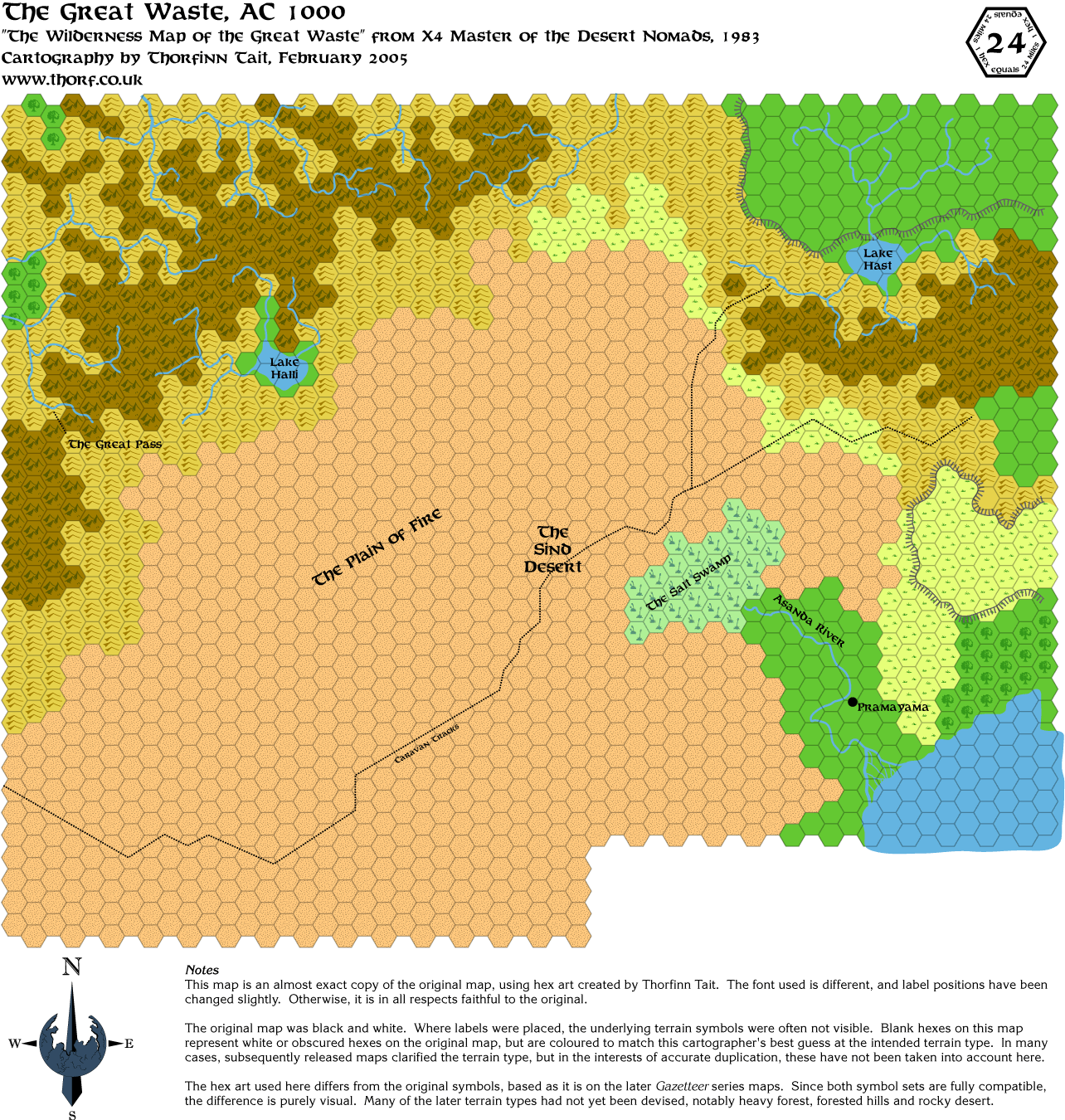
Just in case there's any confusion, this is indeed a replica of the map from X4. As such, it's way out of
date. It's from the first era of Mystaran maps, concurrent with the Expert Set and the B/X/CM/M module
series. Having said that, the later maps in Dragon and Champions of Mystara carry over a surprisingly large
number of this map's features.
Apologies if you find these old maps kinda boring. The results of this "research" will definitely be worth the wait.
|
5 March 2005, 02:40 AM
|
|
Member
|
|
Join Date: Jan 2005
Location: Akita, Japan
|
|
Bigger maps!
I just did new higher resolution versions for the following maps: - Legend
- Known World and Sea of Dread Expert Set/X1 map
- Karameikos ("normal" map only)
- Glantri (evergreen only)
- Ierendi
- Alfheim
- Aengmor
- Rockhome (evergreen only)
- The Northern Reaches (evergreen only)
Ylaruam, Thyatis, Northern Iciria and X4's Great Waste were already in
high resolution. I will try to get the rest of the maps updated soon
too.
The higher resolution files take up a fair bit more space (both visual
size and file size), but they look nicer and the detail comes over
better.
|
5 March 2005, 02:54 AM
|
|
Member
|
|
Join Date: Feb 2005
Location: Utah
|
|
Thorf,
these maps are great! Thanks for doing all the work -- hopefully I can
import them somehow or someway into CC2 (even as a template), though it
will probably be a few days until I try. I really need some permanent
maps in electronic format that I can update for my campaigns!
Quote:
|
Apologies if you find these old maps kinda boring. The results of this "research" will definitely be worth the wait.
|
Your time taken to research all things sure helps me out (and others too, I'm sure) since I haven't taken the time to do it.
Much appreciated!
JTrithen
|
5 March 2005, 08:10 AM
|
 |
Member
|
|
Join Date: Mar 2005
Location: UK
|
|
Quote:
|
Originally Posted by JTrithen
Thorf,
these maps are great! Thanks for doing all the work -- hopefully I can
import them somehow or someway into CC2 (even as a template), though it
will probably be a few days until I try. I really need some permanent
maps in electronic format that I can update for my campaigns!
Your time taken to research all things sure helps me out (and others too, I'm sure) since I haven't taken the time to do it.
Much appreciated!
JTrithen
|
I Agree. Just joined these boards because of the great maps.
I remember when I got X10, that the map what there was, didn't match
X4. Where did Sayr Ulan appear from? why didn't the trail go southwest,
where did this west trail go?
|
5 March 2005, 08:28 AM
|
 |
Member
|
|
Join Date: Mar 2004
Location: Ontario, Canada
|
|
Quote:
|
Originally Posted by Chris.Nix
I Agree. Just joined these boards because of the great maps.
|
Good to have you join us!
Quote:
|
I remember when I got X10, that the map what there was, didn't match
X4. Where did Sayr Ulan appear from? why didn't the trail go southwest,
where did this west trail go? |
Good questions. Made me think why the trade caravan trail would go
through the desert instead of going around? What menace keeps them in
the sands? 
|
5 March 2005, 07:30 PM
|
|
Member
|
|
Join Date: Jan 2005
Location: Akita, Japan
|
|
Saturday's Map
Today's
map is the other half of the pair from X4 and X5. It is also, as Andrew
and I were discussing earlier, the one and only official map of the
whole Hule area.
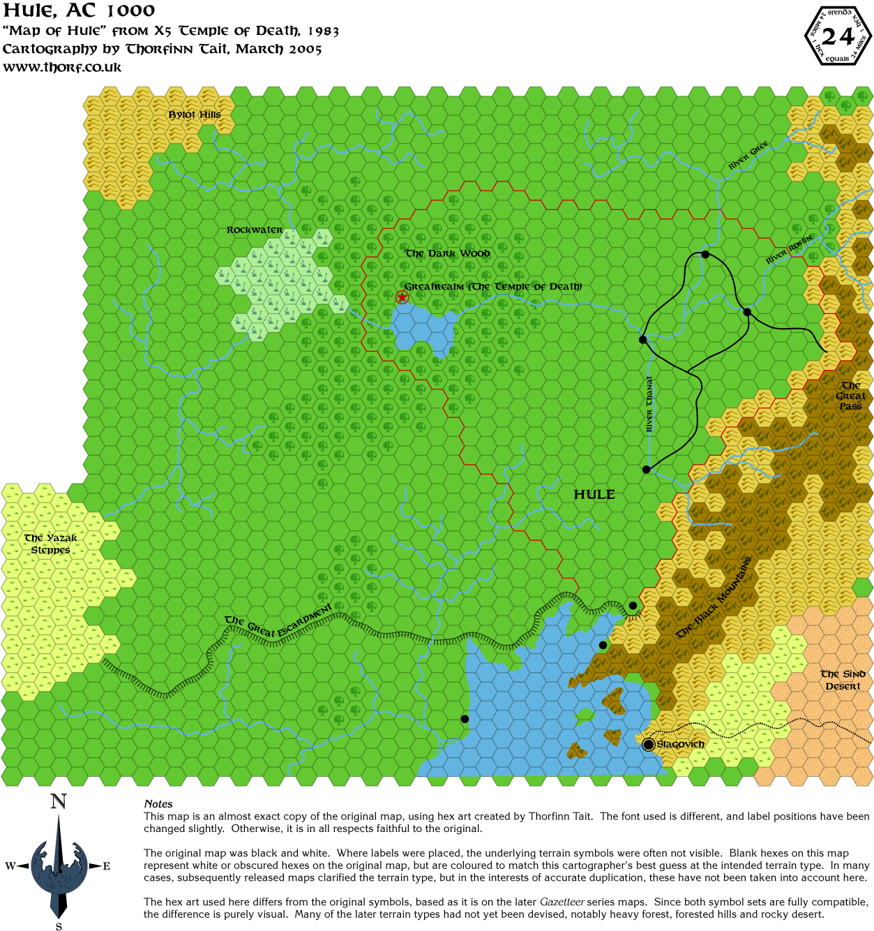
Through all my map studies of late, I am slowly coming to the
realisation that Mystara's maps are divided into two or three different
eras. First there was the Expert Set, and all the B/X/CM/M maps built
on and utilised that map. This was the first era of Mystara's maps, and
it was characterised by simple, mostly black and white symbols, which
generally were more symbolic than they were pictorial. The maps
themselves were low on detail and labels, and consistency between maps
was also not especially high.
Mystaran mapping entered its second era with the release of the
Gazetteers. These maps featured full colour, largely pictorial hex art,
with an ever growing variety of terrain types. Where first era maps had
desert, for example, second era maps had a choice between desert, rocky
desert, broken lands, bad lands and so on. These new maps also featured
a much higher level of detail, partly due to the standardisation of the
high detail 8 mile per hex scale. Due to these new factors, first era
maps were changed, developed and expanded upon to a much greater extent
than ever before.
There wasn't really a third era of maps as such. The mapping style did
change again with the release of AD&D Mystara, Red Steel and the
Savage Coast sets, but there were very few new features or developments
as a result of these changes in style. AD&D Mystara maps had a
simple hex art revision while retaining the same basic mapping
conventions and maps. Red Steel and the Savage Coast did away with
hexes altogether, but the replacement maps still featured the same
details as the original maps.
If this topic interests you, you may like to know that as I remake
these maps, I am working on an article tentatively called "The History
of Mystara's Maps", which I will release eventually as part of my
Secret Project.
|
5 March 2005, 07:50 PM
|
|
Member
|
|
Join Date: Jan 2005
Location: Akita, Japan
|
|
 Replies
Quote:
|
Originally Posted by JTrithen
Thorf,
these maps are great! Thanks for doing all the work -- hopefully I can
import them somehow or someway into CC2 (even as a template), though it
will probably be a few days until I try. I really need some permanent
maps in electronic format that I can update for my campaigns!
|
You're welcome to do that. If anyone has information on how to import
things into CC2 I'll be happy to provide you with the files in the
right format. Personally I checked out CC2, but when it comes to hex
mapping I'm more happy with Illustrator - for now.
Quote:
|
Your time taken to research all things sure helps me out (and others
too, I'm sure) since I haven't taken the time to do it. Much
appreciated! |
My pleasure. I'm really enjoying working on this project.
Quote:
|
Originally Posted by Chris.Nix
I Agree. Just joined these boards because of the great maps.
|
Great! It's nice to have people appreciating my work, but it's even
better to have people start contributing to the forum because of it. 
|
6 March 2005, 04:15 PM
|
|
Member
|
|
Join Date: Jan 2005
Location: Akita, Japan
|
|
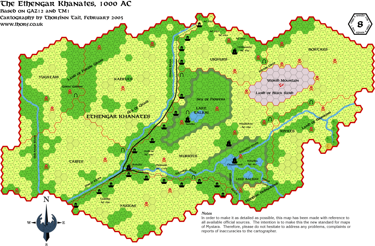
Sunday's Map
Not much progress so far this weekend, I'm afraid. And I have a friend coming to visit for two weeks starting
on Thursday, so I might yet have to take a break from posting maps every day. On the other hand, by my count
today's map will be the 23rd, meaning that I've continued with a map a day for more than three weeks now!!
In any case, here is the map.
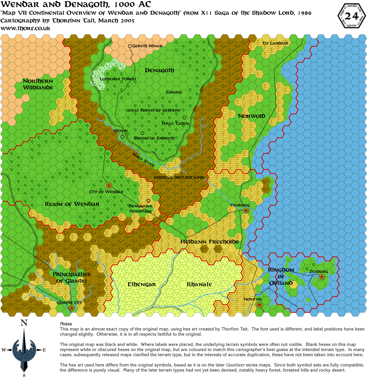
From my notes:
This region, directly to the north of the Known World, was detailed for the first time in this map from X11 Saga of
the Shadow Lord. The lower quarter of the map duplicated the top of the Expert Set map, but while at first glance
it may look identical, unfortunately it is in fact significantly different. Discrepancies include slightly different courses
for rivers and trails, a new contracted border for Ethengar, and most glaringly Ostland was moved a hex down and
to the left.
Wendar and Denagoth were later featured on the Wrath of the Immortals set maps, and also had maps in the Poor
Wizard's Almanac series. These maps will follow at a later date.
|
6 March 2005, 05:50 PM
|
|
Member
|
|
Join Date: Apr 2004
Location: Long Beach, CA
|
|
Quote:
|
Originally Posted by Thorf
The lower quarter of the map duplicated the top of the Expert Set map,
but while at first glance it may look identical, unfortunately it is in
fact significantly different. Discrepancies include slightly different
courses for rivers and trails, a new contracted border for Ethengar,
and most glaringly Ostland was moved a hex down and to the left.
|
Heh- wait'll you try and combine that map with the trail maps and the
CM series of maps. I think you'll probably find that, though the CM
series claims to be at 24 mi/hex, it should probably read 36 mi/hex.
Otherwise, you're going to end up with a large inlet where Landfall
"runs into" the map you've just posted- a bay that Geoff Gander ended
up naming "Kamminer Bay", and which seems to have been largely adopted
by the Mystara community in its collective mapping efforts ever since.
Boy was that a headache to work out...
|
6 March 2005, 11:24 PM
|
|
Member
|
|
Join Date: Jan 2005
Location: Akita, Japan
|
|
 I know you keep taunting me with that one...
...but
I've been wondering, how does the 72 mile per hex map from Dawn of the
Emperors fit in there? Does it have everything at the right scale?
In any case, I'm getting slowly closer to the point where I have to
start dealing with Norwold. I'm sure I'll be venting my frustrations
over this issue here soon enough.
|
7 March 2005, 02:18 AM
|
|
Member
|
|
Join Date: Apr 2004
Location: Long Beach, CA
|
|
Quote:
|
Originally Posted by Thorf
...but
I've been wondering, how does the 72 mile per hex map from Dawn of the
Emperors fit in there? Does it have everything at the right scale?
|
I've never really compared the 72 mile map all that much, to be honest,
so I can't say for sure. It would be interesting to find out, though.
[EDIT] Scratch that- I just checked my DotE 72 mi map and noticed that
I did at some point check things out. The most notable thing is that
the outcropping of land to the east of Freiburg is missing, though I
don't think it existed at the time of the map's creation (the Trail
maps only went as far as just below Freiburg).
Interestingly enough, though, it is still missing on the 48 mile map
from WotI, despite being on the 24 mile map. The WotI map, IIRC, is the
first time we ever saw that much of Heldann, so you'd think the two
maps in that set would have been more consistent on that point.
I know I keep taunting you about Norwold, but honestly, I'm really
curious to see what you come up with. I've done the Norwold thing twice
now (with slightly differing results, due to a different method of
scaling down that I currently use), but to my knowledge, no one else
has done it- Thibault maybe, although I've never talked to him about
it. I've only noticed him using the "Kamminer Bay" fix that I stumbled
upon and that Geoff named in one of his Norwold maps. I don't know if
he ran into that problem himself or just worked off the previous "fix".
So I'm looking forward to your thoughts on the matter. It may turn out not to be the best solution after all.
Last edited by Cthulhudrew : 03-07-05 at 02:27 AM.
|
7 March 2005, 02:59 AM
|
|
Member
|
|
Join Date: Jan 2005
Location: Akita, Japan
|
|
Updates
Yep. I'm looking forward to it.
Well, I spent a few hours today sorting scans in preparation for the
next batch of maps. It takes rather a long time to rotate the map until
it's perfectly straight, then resize it until it fits under my hex grid
just right. And of course that has to be done for every single
scan/page of each map.
I also updated my template to streamline the map-making process, but
unfortunately all this preparation and sorting meant I didn't get any
actual mapping done. Oh well.
I have just updated the rest of the maps to the new resolution, and I
made some corrections while I was at it. Here's the list of updated
maps: - The Five Shires
- Minrothad
- Upper Broken Lands
- Lower Broken Lands (also added in bridges)
- Darokin
- Ethengar
- Shadow Elf Territories
- Atruaghin Clans
- Thyatis (added Blackpoint)
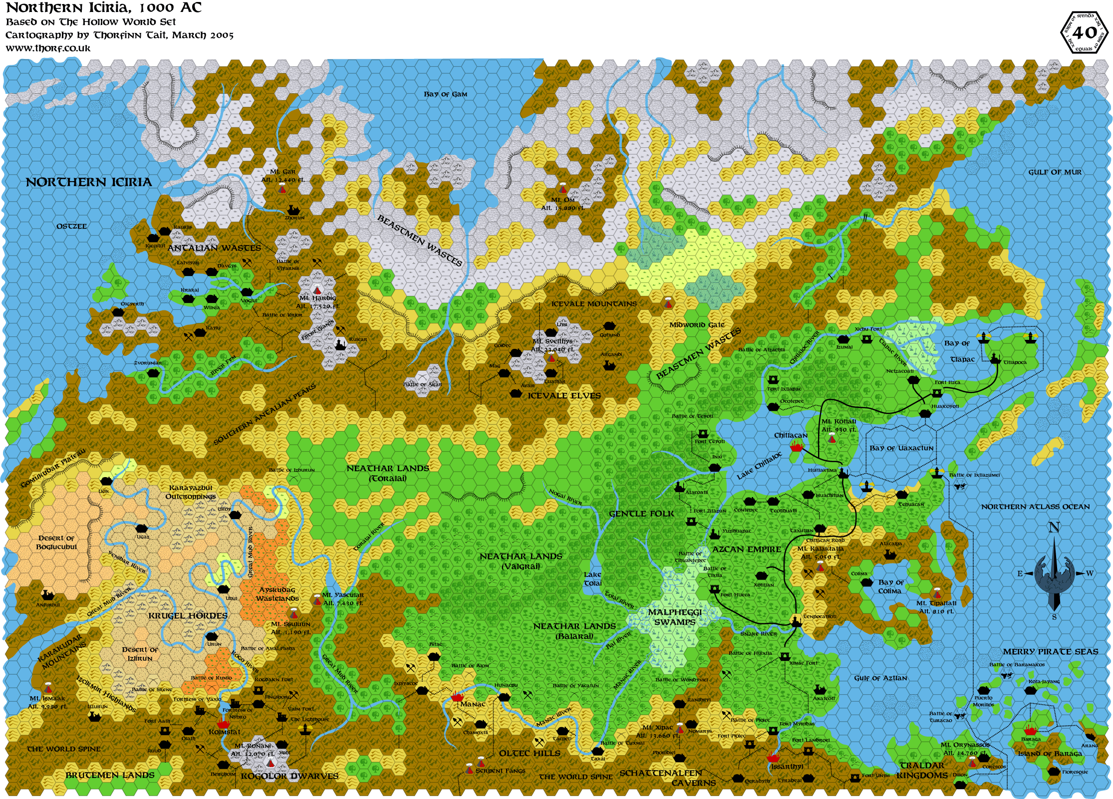
- Northern Iciria, Hollow World (added in Quauhnahuac, a couple of labels in Azca, and rapids)
- Alfheim (changed forested hills to hills with great home trees)
That brings almost all the maps up to date. The only exceptions are a
few variants and a few historical maps early on in this thread, which I
don't really think are high priorities at this point.
Talking of priorities, I thought now would be a good time to ask everyone:
What maps do you want to see?
I do have a rough plan, but there's not really a set order I have to do
the maps in. So, if you want to see a specific map/country/area, why
not tell me so I can give it a bump up the list.
|
7 March 2005, 03:07 AM
|
 |
Member
|
|
Join Date: Feb 2004
Location: Vienna, Austria
|
|
Im interested in an updated map of Sind and the Sind Desert from the CoM Source!
|
7 March 2005, 03:35 AM
|
|
Member
|
|
Join Date: Jan 2005
Location: Akita, Japan
|
|
Quote:
|
Originally Posted by Cthulhudrew
I know I keep taunting you about Norwold, but honestly, I'm really curious to see what you come up with.
|
Hehe, I see you've noticed my stubborn-ness in checking things out for myself.
I've thought about doing the Isle of Dawn next, because it seems as if
it might help when it comes to Norwold. I'm also considering doing the
other parts of Thyatis, and Alphatia quite soon.
|
7 March 2005, 02:28 PM
|
|
Member
|
|
Join Date: Mar 2004
Location: Stockholm, Sweden. For a while.
|
|
Quote:
|
Originally Posted by Thorf
What maps do you want to see?
|
Well, I would like to see the rest of the Empires (Alphatia, Isle of
Dawn, Thyatian colonies - especially the Hinterlands.) - so I'm glad to
hear they're soon to be done.
I'd also like to see Undersea.
And some coffee, please.
|
7 March 2005, 10:41 PM
|
|
Member
|
|
Join Date: Jan 2005
Location: Akita, Japan
|
|
I
began preparing the other Dawn of the Emperors maps last night, but I
still have yet to start on the Alphatia and Isle of Dawn maps. Both
should be quite fun to do, though.
Today I've spent some time on Atruaghin and Sind again. It seems there
might be even bigger problems there than I thought. From my initial
comparisons, it appears that in fixing the Atruaghin plateau they may
have introduced another problem into the coastline. Anyway, more on
that when I've completed the Champions of Mystara and Wrath of the
Immortals maps, which should show me how they dealt with the issue.
Edit: I just had a quick look at Champions of Mystara's Great Waste
map, and it seems they have fixed the problem with the coastline.
Basically, in Dragon 169 they brought the coastline too far west,
meaning that the plateau was bigger but if you tried to draw a map that
included the Known World, there wouldn't be space. They fixed this
apparently by adding in a couple more hexes on the straight bit of
coastline from Jahore to the Atruaghin bay.
PS - Sorry, I don't have any coffee. Would you like a cup of tea instead?
Last edited by Thorf : 03-07-05 at 10:49 PM.
|
|
|
