Thorf's Secret Project: Stage One
A recreation of the Mystara Message Board thread that started the Atlas of Mystara project, with restored links and images.

Apr 13, 2006 21:44:03
|
|
|
Join Date: Apr 2005
Location: Seattle area
|
|
Thorf,
Beautiful map, as always!
One question, whenever I right-click and Save Picture As, it comes up with Untitled for the file name and BMP for the file type. Any idea why that might be?
Gordon
|

Apr 14, 2006 3:19:54
|
 |
|
|
Join Date: Jan 2005
Location: Akita, Japan
|
|
Quote:
|
Beautiful map, as always!
One question, whenever I right-click and Save Picture As, it comes up with Untitled for the file name and BMP for the file type. Any idea why that might be?
|
Gordon, that's a bug I have encountered online sometimes too. I'm afraid I don't know the solution. 
|

Apr 14, 2006 10:05:21
|
|
|
Join Date: Apr 2005
Location: Seattle area
|
|
Quote:
Gordon, that's a bug I have encountered online sometimes too. I'm afraid I don't know the solution.  |
Just out of curiosity, I tried it using different browsers. The problem occurs in Netscape and IE, but not in Firefox and Opera, so I'm thinking it's browser-related. Normally, I use IE because it seems to work the best with the largest number of sites I go to, but it looks like I should use a different one when coming here.
Gordon
|

Apr 14, 2006 19:47:37
|
 |
|
|
Join Date: Mar 2006
Location: Empire of Zuyevo, Brun (Texas)
|
|
so what do the other web browsers try to save it as?
|

Apr 14, 2006 21:51:46
|
|
|
Join Date: Apr 2005
Location: Seattle area
|
|
Quote:
|
so what do the other web browsers try to save it as?
|
A PNG file with an appropriate name - most likely the actual file name.
Gordon
|

Apr 14, 2006 23:13:44
|
 |
|
|
Join Date: Mar 2006
Location: Empire of Zuyevo, Brun (Texas)
|
|
Which are better? PNG OR Bitmap?
|

Apr 14, 2006 23:40:54
|
 |
|
|
Join Date: Jan 2005
Location: Akita, Japan
|
|

Quote:
|
Which are better? PNG OR Bitmap?
|
Bitmap files are uncompressed. As such, they will record every pixel and colour as is, but at the cost of a reasonably large file size.
PNG files are more efficient, providing lossless compression. There are two basic types, 8 bit and 24 bit. 8 bit limits the number of colours to give a smaller file size.
GIFs also provide lossless compression by limiting the palette, and are similar to PNGs in many ways. However, their compression often doesn't look as nice as PNG compression - something to do with the way they handle colours, I think.
Finally, JPGs (or JPEGs) give lossy compression - they throw away data in order to minimise the file size. This gives rise to "artifacts", the strange digital patterns that we see so often nowadays on the computer, as well as on digital TV channels. JPGs are best for dealing with complex images such as photos. The compression rate can be set, so they are capable of providing high quality as well as low quality, and the file size increases with the quality.
Edit: I use 8 bit PNGs for all my maps, with a Perceptual palette. Generally it works extremely well.
|

Apr 15, 2006 4:53:22
|
 |
|
|
Join Date: Jan 2005
Location: Akita, Japan
|
|
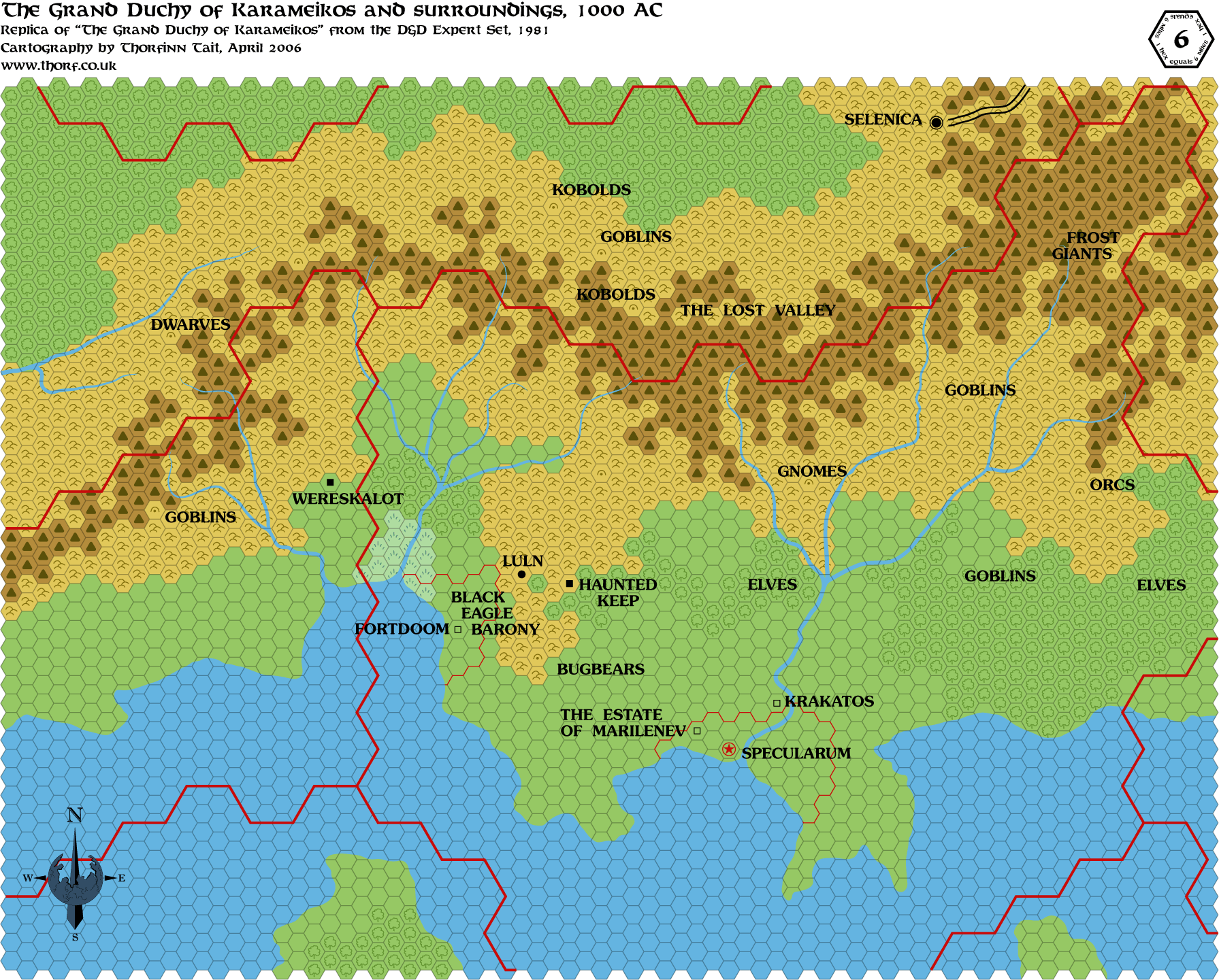
Here's the first ever large scale map of the Known World, from the original Expert Set in 1981. It was released concurrently with
the X1 The Isle of Dread, making this map one of the two first ever Known World maps - the other being X1's Known World and Sea of Dread map.
 |

Apr 15, 2006 6:04:39
|
 |
|
|
Join Date: Feb 2006
Location: Rome, Italy
|
|
Interesting map!
I totally forgot of all humanoids labels, but frost giants.
Interesting:
Highforge area is labeled with gnomes!
Dymrak woods labeled with goblins!
Callarii & Vyalia with elves!
In later editions (as 5 Shires & Darokin Gaz) I don't remember any clue about goblins and dwarves in the Shire/Darokin border.
And where the great carovan road is (not marked in the map) here I see koblods and some goblins...
Where did eventually all these humanoids/demihumans ended?
|

Apr 15, 2006 12:47:32
|
 |
|
|
Join Date: Mar 2006
Location: Empire of Zuyevo, Brun (Texas)
|
|
Wasn't Threshold on this map? It is on my copy out of the Expert Set.
|

Apr 15, 2006 12:51:37
|
 |
|
|
Join Date: Jan 2005
Location: Akita, Japan
|
|
Quote:
|
Wasn't Threshold on this map? It is on my copy out of the Expert Set.
|
This is the map from the very first Expert Set, released in 1981. Surprisingly enough, it didn't have any mention of Threshold. 
Compare it with your Expert Set (presumably the 1983 version or a reprint of it) and you will notice that in fact this map shows a much wider area, with some more details. It also deletes all the caves for some reason.
I will be posting the 1983 version very soon (probably tomorrow) - it's almost finished already, because it's a relatively close match with the 1981 map, so I am just tweaking the changes and cropping it.
|

Apr 15, 2006 12:57:18
|
 |
|
|
Join Date: Mar 2006
Location: Empire of Zuyevo, Brun (Texas)
|
|
Yeah after I posted I realized that my copy is from 1983. Excellent map. These "generic" ones are excellent to give to players without spoiling what else is out there.
|

Apr 16, 2006 5:04:31
|
 |
|
|
Join Date: Jan 2005
Location: Akita, Japan
|
|
Here's the version that appeared in the 1983 Expert Set.
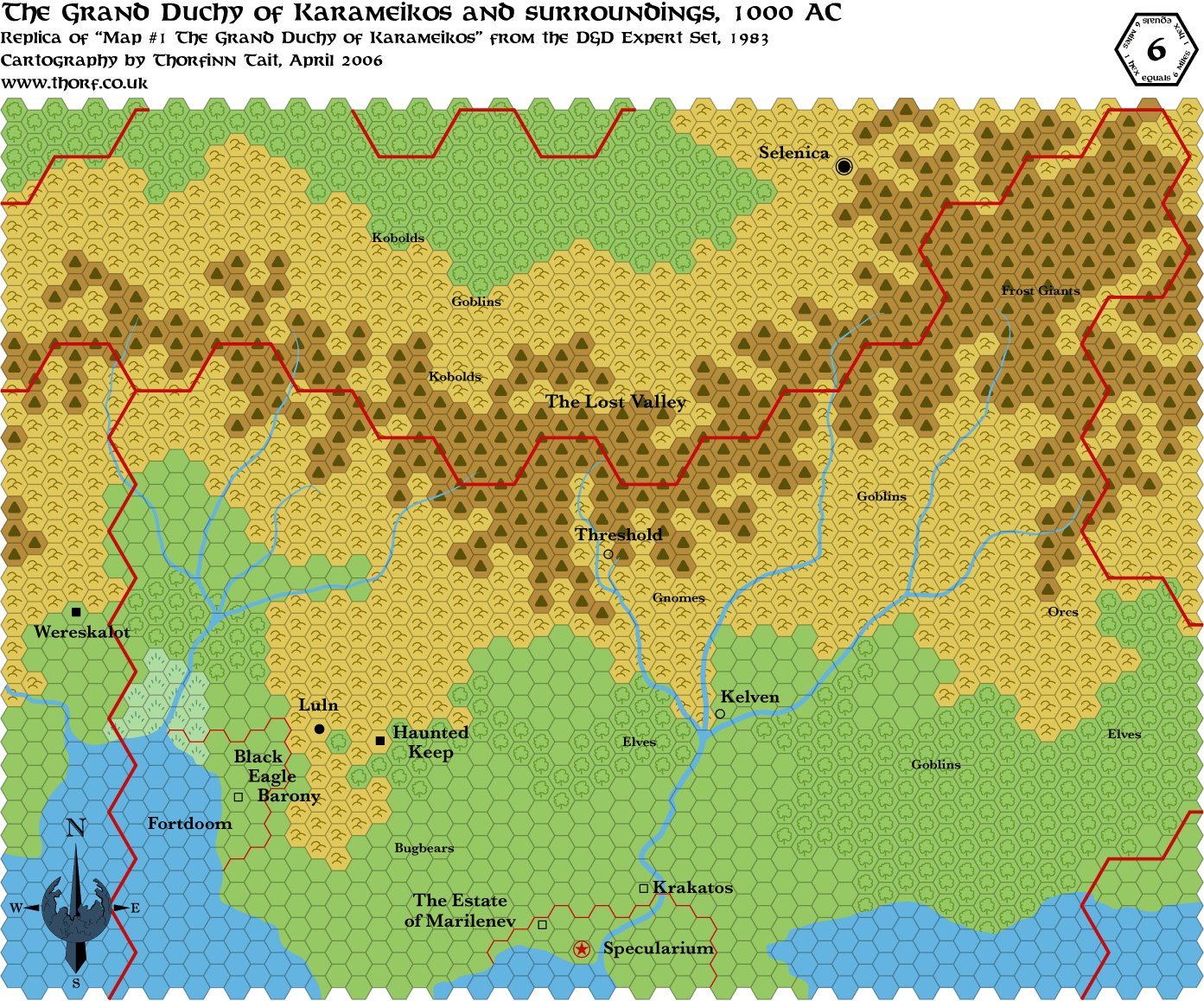
A couple of hexes were changed around, and all of the caves were changed to plain hills. Threshold and Kelvin make their first appearances,
as does the Windrush River - the small tributary of the Foamfire River that leads to Threshold. Kelvin was spelt "Kelven" at this time, both on
the map and in the text, although the 24 mi per hex map lists it as "Kelvin", which is the spelling that was later adopted as correct.
The most surprising mistake is that Specularum is mis-spelled as "Specularium". Even more surprising is that I never noticed the mistake until
now, through all these years of reading about and playing D&D.  |

Apr 17, 2006 10:50:07
|
 |
|
|
Join Date: Mar 2006
Location: Empire of Zuyevo, Brun (Texas)
|
|
 Yeah this one looks right 
I wonder why they changed the map so much in just a 2 year time? Seems to me they should have just added to the one from 1981.
|

Apr 17, 2006 10:59:10
|
 |
|
|
Join Date: Jan 2005
Location: Akita, Japan
|
|
Quote:
 Yeah this one looks right 
I wonder why they changed the map so much in just a 2 year time? Seems to me they should have just added to the one from 1981. |
It's stranger than that... They DID just add to the 1981 map (or at least some layers of it), I believe, because if you look closely at the 1983 map you can actually see the older map's rivers looking slightly greyed out beneath the ever-so-slightly different newly drawn rivers. 
|

Apr 17, 2006 23:23:36
|
 |
|
|
Join Date: Jan 2005
Location: Akita, Japan
|
|

I wrote these a couple of days ago but couldn't get them posted, then forgot about them. So here they are now...
Quote:
|
(While you're at it, did you have any plans to make Thorf-editions of Geoff Gander's maps & Christian Constantine's maps? Gander did that huge Davania series, plus Wendar-Denagoth, plus the Heldannic Freeeholds. Constantine did Hule in 8m with detailed political subdivisions, plus that HUGE map of far-western Brun. Those guys' maps seem practically official now. Maybe time that they get the Thorf treatment?)
|
I'm finally getting to answering you in full, Haldemar. 
Eventually I hope to cover as much of the world as possible, so the simple answer is yes. However, the amount of time it takes to do accurate mapping is really quite a lot, and it increases exponentially the further you move away from the Known World and the Savage Coast. 
Nevertheless, I have actually started prepping Geoff's Davania maps by putting them all together, and I will get to it hopefully before too long - although right now I am quite busy with official maps still.
Quote:
|
Seriously, I'd be interested in knowing what the aspect issues are for the Davania maps. When I created them, they were designed to overlap slightly, and the model I used was the world map in the HW boxed set - it was the only one that showed vegetation zones and other features that I could use. Obviously there would be some distortions, but I would be interested in discussing this when you have the time.
|
I haven't examined this myself yet, although I did do a comparison with the original Master Set Davania, since I have it easily available. It didn't fit very well, even with stretching - but that's not at all surprising considering that your source was the Hollow World set map.
There was one mistake that I noticed, though. When joining the northeastern sections together, I noticed that one area is a hex out of phase on the overlapping section of two of the sheets. I think the area was the Jungle Coast, and it's not a big problem - you just have to choose which one to put on top.
Other than that one minor issue, though, the sheets fitted together exceedingly well, which is an amazing feat for hand-drawn maps covering such a wide area. I am even more impressed with your cartography skills than I was before, Geoff. 
Which brings me back to thinking about something that occurred to me recently. There are a lot of things about the maps that I don't realise or notice at all until I (re)make them for myself. This is the case with official maps, as well as fan-made maps. I'm referring to small details, but also mistakes, brilliant solutions to problems, etc., that you just don't get from looking at the maps. This is I think probably the primary reason why all of us cartographers tend to work individually, quite often duplicating and remaking each other's work.
The short version: in order to understand a map fully, you have to get inside it, pull it apart and put it back together again.  |

Apr 18, 2006 8:18:20
|
|
|
Join Date: Feb 2005
Location: Ontario, Canada
|
|

Quote:
There was one mistake that I noticed, though. When joining the northeastern sections together, I noticed that one area is a hex out of phase on the overlapping section of two of the sheets. I think the area was the Jungle Coast, and it's not a big problem - you just have to choose which one to put on top.
Other than that one minor issue, though, the sheets fitted together exceedingly well, which is an amazing feat for hand-drawn maps covering such a wide area. I am even more impressed with your cartography skills than I was before, Geoff.  |
Thanks Thorf! 
I wouldn't be surprised if a couple of errors made their way into those maps - I don't even want to think of the calculations I made to maintain the scale ration between the HW map and what I drew. Despite all that, I'm very happy that people like them, and use them - and I am very curious to see what comes out of your efforts. The one thing I might suggest is contacting Thibault - he is currently developing integrated hex maps of Davania using Hexmapper, and he's done the western half of it already. It might save you some time and trouble.
Geoff
|

Apr 18, 2006 12:03:39
|
|
|
Geoff
On the northern coast of Davania (Hinterlands area) did you use the map for DotE or PWAII? I seem to remember (from constructing my 72 mph map) that the two sources disagree on the position of this coast by a couple of hundred miles in places.
|

Apr 18, 2006 14:01:09
|
|
|
Join Date: Feb 2005
Location: Ontario, Canada
|
|
Quote:
|
Geoff
On the northern coast of Davania (Hinterlands area) did you use the map for DotE or PWAII? I seem to remember (from constructing my 72 mph map) that the two sources disagree on the position of this coast by a couple of hundred miles in places.
|
I consulted both, but used PWA II - the coastline seemed to match the HW boxed set to a better degree, and the was more detail that I could use.
Geoff
|

Apr 21, 2006 16:16:56
|
 |
|
|
Join Date: Jun 2003
Location: Christiansburg, VA. North of Specularum.
|
|
Thorf,
Have you considered doing maps of the cities and towns of Mystara? I know I would use maps for Specularum/Mirros and Kelven as well as the other major cities and towns in the country.
--Ray.
|

Apr 21, 2006 22:01:18
|
 |
|
|
Join Date: Jan 2005
Location: Akita, Japan
|
|
Quote:
|
Have you considered doing maps of the cities and towns of Mystara? I know I would use maps for Specularum/Mirros and Kelven as well as the other major cities and towns in the country.
|
As a matter of fact, yes. And I have been working on one in particular for the last few weeks, as a sort of experiment.
Unfortunately, I can't see that there are any shortcuts to making city maps, which means that they have to be drawn manually. Obviously this means that each map takes a long time to finish...
|

Apr 27, 2006 21:26:50
|
 |
|
|
Join Date: Mar 2006
Location: Empire of Zuyevo, Brun (Texas)
|
|
Hey Thorf. I was wondering when you were going to have a new map here...and I am having a problem seeing your maps of the Legands at your site. They are accessible through the boards but not on your website. I like the thumbnails to see what I am getting into  |

Apr 27, 2006 22:03:48
|
 |
|
|
Join Date: Jan 2005
Location: Akita, Japan
|
|
Quote:
Hey Thorf. I was wondering when you were going to have a new map here...and I am having a problem seeing your maps of the Legands at your site. They are accessible through the boards but not on your website. I like the thumbnails to see what I am getting into  |
I'm afraid I can't say when I'll next post a map... Things have become busy at work for me this week, and I have a lot of other projects on the go too. Since I just work on whatever one feels best at the time, my schedule is a bit random. 
Regarding the legends, they are there, but the URL is wrong. If you delete the "_00_/" part of the URL you can see them. I haven't had time to contact Shughuy about this yet, but hopefully I can get it fixed soon.
Thanks for the heads up - it's the sort of mistake I would never find, since I don't waste my own bandwidth by downloading my own maps. 
|

Apr 29, 2006 16:51:35
|
 |
|
|
Join Date: Jan 2005
Location: Akita, Japan
|
|

I just updated quite a few maps. I have marked them in the index in the first post of this thread, so please check there for the links.
Among the updates is a new map:
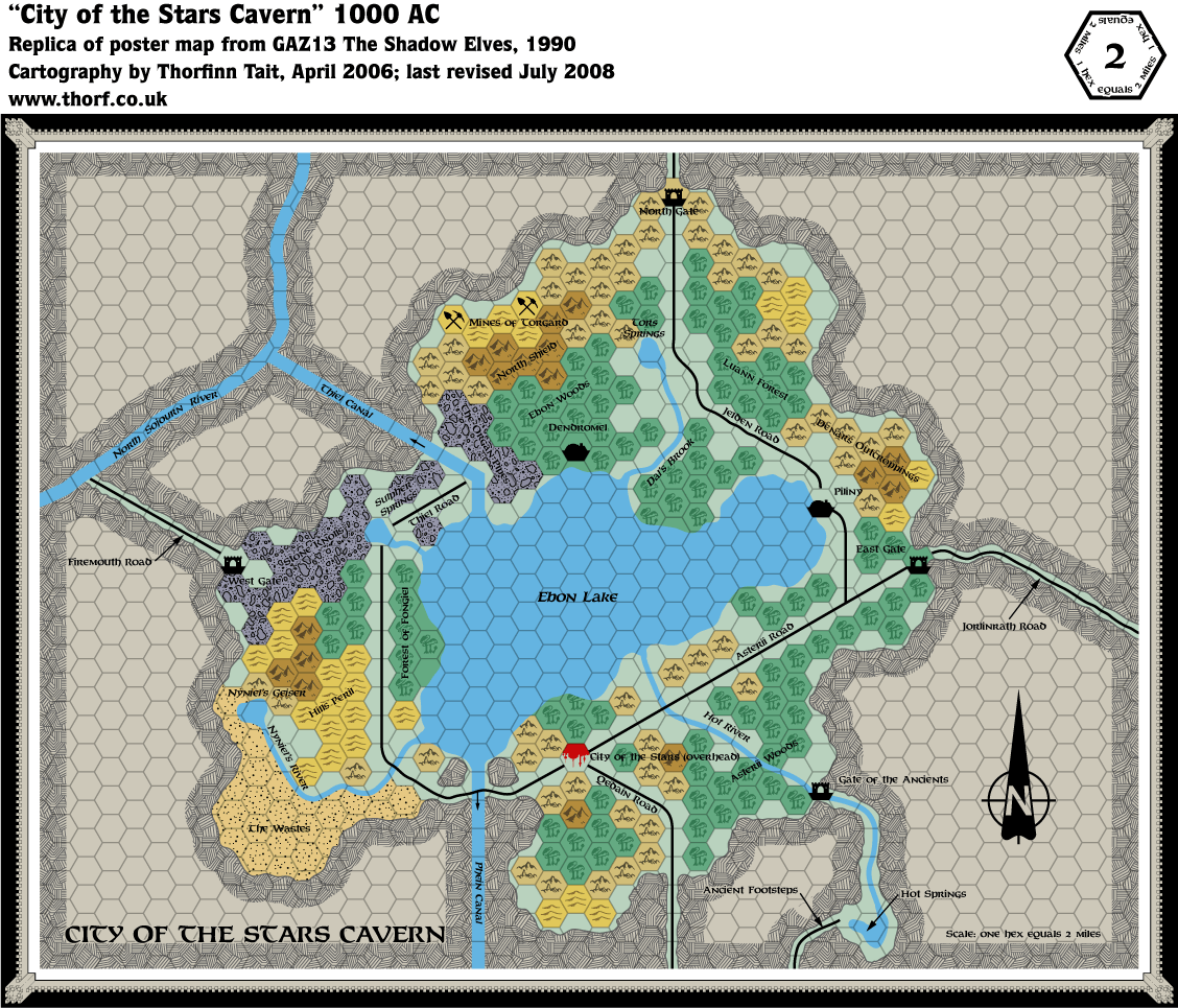
Also its updated version - there are only two very small corrections, as noted below.
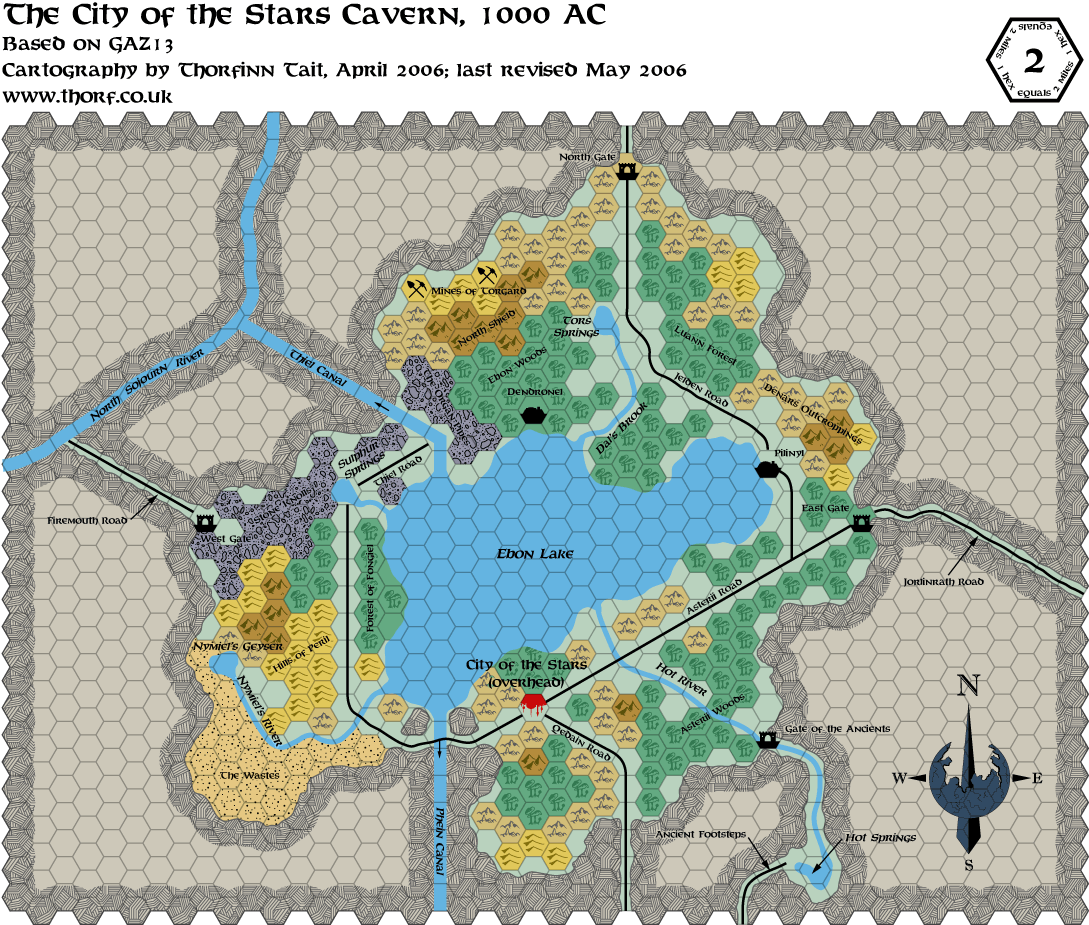
The two changes are both spelling mistakes: Sulpher Springs and Nyniel's Geiser.
This map took a looooong time to make. It is quite a simple map overall, and in fact I did the time-consuming part of drawing in the rivers, lakes and cavern walls over a year ago. However, it includes two new pattern symbols, each of which took over 4 hours of work. 
The patterns in question are the crosshatching stone wall pattern and the rocky terrain symbol. I couldn't find anything in my various Ilustrator collections that approximated these as closely as I wanted, so I did them from scratch. What this means is that I painstakingly traced the patterns from the original map, referring to different sections of the map to put together the original pattern. (The original pattern is big enough that it is not wholly visible in any one place on the map, you see.)
So the crosshatching pattern is 99% faithful to the original map. I hope I can find another use for it after spending so much time on it!
The rocky terrain pattern is based on my recreation of 15 of the 25 hexes of it which are featured on the original map. This is the only map that uses that symbol, and I couldn't see an overall pattern, so I put together my own based on those hexes. If necessary it is quite possible to add the pattern from the remaining 10 hexes at a later date - doing so would probably make the pattern look less repetitious.
It occurs to me that this is an awful lot of work to go to on these maps if I'm never going to use the symbols again. One of the things I have on my to do list is more maps like this one, showing a city and its immediate surroundings; I may have to do some experimenting with some of the other Shadow Elf caverns. 
While on the subject of this map, has anyone else ever noticed that the City of the Stars is on the ceiling, and yet has roads leading to it? Moreover, shouldn't there be a celing map, too? (I may have brought this up before, possibly even in this thread...)
I don't think there was any detail given on the logistics of having the city on the cavern roof. Surely there must be easy ways to reach the roof other than climbing the walls. I would have thought that they'd have a road of some kind, because having your capital city on the roof, cut off from trade routes and so on doesn't sound very viable. |

Apr 29, 2006 18:57:25
|
 |
|
|
Join Date: Jan 2005
Location: Akita, Japan
|
|
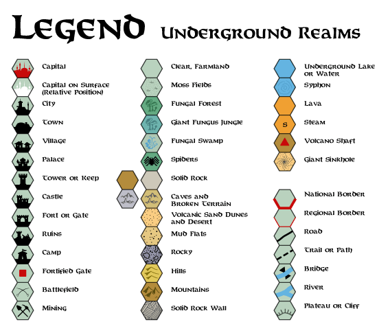
I finally got round to making the legend for underground maps - only a year or so late. 
 |

Apr 29, 2006 21:31:39
|
 |
|
|
Join Date: Dec 2005
Location: Texas
|
|
The roads would, I think, probably lead to some point from which you could get some way to fly up to the city.
|

Apr 30, 2006 2:44:21
|
 |
|
|
Join Date: Jan 2005
Location: Akita, Japan
|
|

I found the answer to the inaccessibility question.
Quote:
|
Into and out of the City
To start with, there is the pressing problem of getting into and
out of the City of the Stars itself. Skinwing flying is one obvious
possibility, but skinwings can carry virtually no cargo, so this
has limited usefulness (the army has most of them anyway). Magic is
a possibility ( being the obvious spells).
But there are still problems--what about 1st-level characters? What
about merchants with cargo to shift?
The problem is fortunately solved by the existence of what the
shadow elves call "gravity flutes," narrow cylinders of altered
gravity which exist at the sides of the Great Cavern near the City
of the Stars. Gravity flutes are not found more than 10 miles from
the City of the Stars. Shadow elves call them because they
are cylindrical in shape and because there seems to be a gentle,
almost inaudible sighing of an unfelt breeze within them. (Other
races do not hear this.)
A gravity flute is 5-30 feet wide. A shadow elf entering one can
at once recognize it by a rising of the hairs at the nape of his
neck (other races must make a Wisdom check to recognize gravity
change here unless they experiment).
When a gravity flute is entered, the wall becomes "down." One
simply steps off the floor (Great Cavern) on to the wall (which is
now the floor). When one reaches the ceiling of the Cavern (City of
the Stars), this is of course just another wall (while you are
inside the gravity flute), until you step out on to it, when it
becomes the floor.
It takes 1d20 rounds to find a gravity flute, or 2d20 rounds if
the seeker is more than 5 miles from the City, since they move
around slightly and are rarer the further one goes from the City.
Movement rate within the gravity flute is at normal speeds.
|
This explains how merchants get to the city on the roof of the cavern with their wares, as well as why the roads converge below the city - because you have to go to the area below the city to find a gravity flute. |

Apr 30, 2006 16:36:34
|
 |
|
|
Join Date: Dec 2005
Location: I remember there was mist...
|
|
If you look at the map carefully, that places all teh gravity flutes just east of the Phein canal, as the description implies they must be next to a cavern wall. One wonders why this area isn't more developed.
|

May 06, 2006 9:36:32
|
 |
|
|
Join Date: Jan 2005
Location: Akita, Japan
|
|
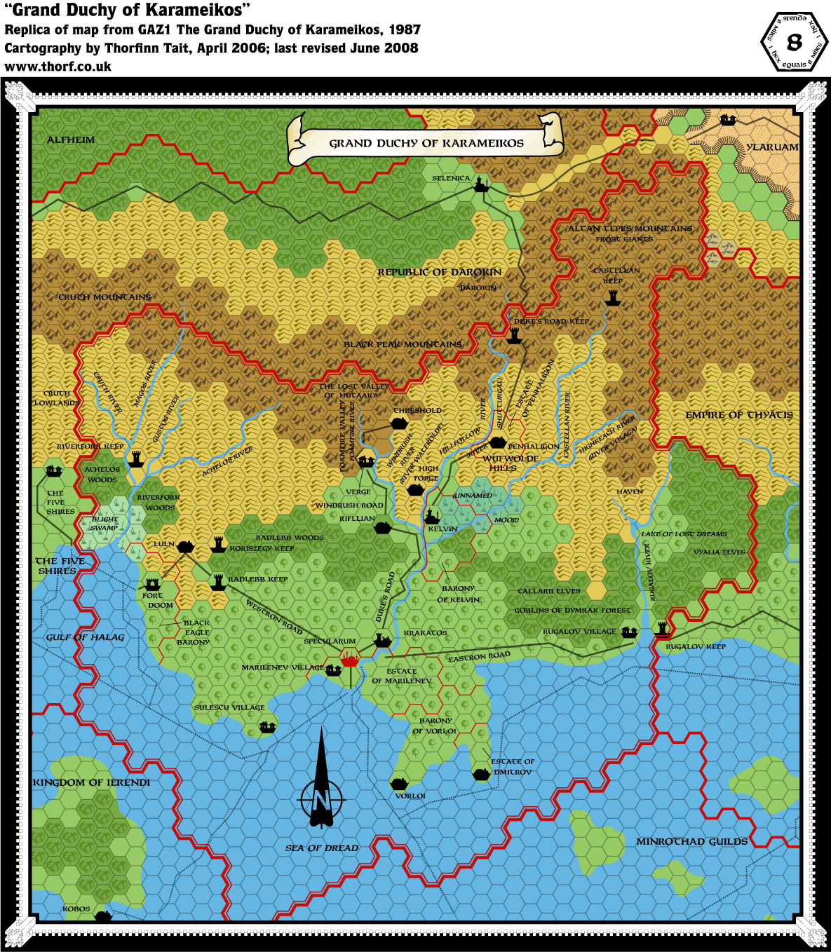
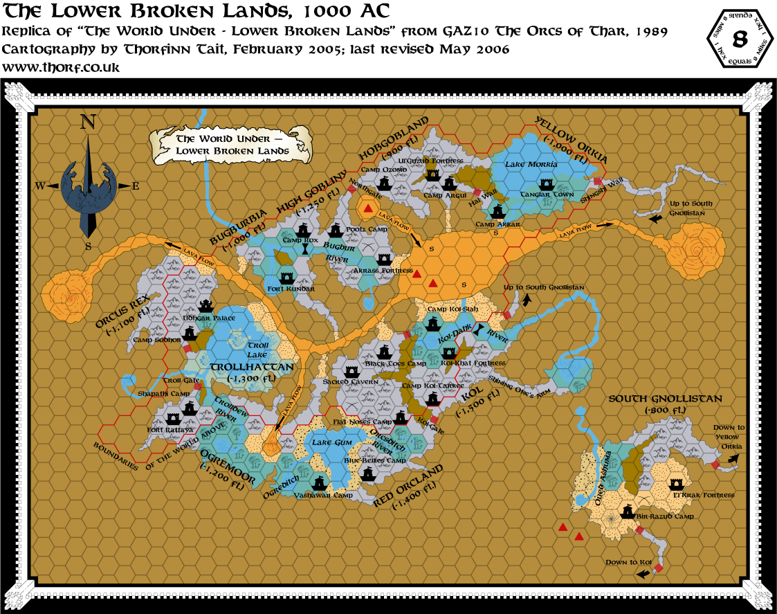
Secret message for MMB readers. The following maps have been updated:
This post will self-destruct in one week.
Edit: Fixed the links. I hit preview halfway through writing by mistake, and it did something strange to the URLs that I didn't notice. |

May 06, 2006 10:01:28
|
 |
|
|
Join Date: Mar 2004
Location: Ontario, Canada
|
|
Quote:
|
This post will self-destruct in one week.
|
lol. Unforntunately, the links don't work for me  .
[EDIT] You can see the maps if you delete the last part of the address that looks like this " %5B/URL ". [/EDIT]
|
|
|