Thorf's Secret Project: Stage One
A recreation of the Mystara Message Board thread that started the Atlas of Mystara project, with restored links and images.

19 May 2005, 01:41 AM
|
 |
Member
|
|
Join Date: Jan 2004
Location: Italy
|
|
 Alatians
Just
a quick note to share an idea on the Alatians we had over the Italian
MMB: they are prolly the homeland of the original Alasiyans (see the
similarity in the names?), who were enslaved by Nithians when they
settled Thothia and were then deported in part to mainland Nithia and
Thothia.
After Nithia's downfall, the Alphatians claimed the isles which were
pretty devoid of their former inhabitants, subjugated the few Alasiyans
still living there and renamed them..
|
19 May 2005, 02:18 AM
|
 |
Member
|
|
Join Date: Mar 2004
Location: Norway, Europe
|
|
Quote:
|
Originally Posted by DM
Just
a quick note to share an idea on the Alatians we had over the Italian
MMB: they are prolly the homeland of the original Alasyians (see the
similarity in the names?), who were enslaved by Nithians when they
settled Thothia and were then deported in part to mainland Nithia and
Thothia.
After Nithia's downfall, the Alphatians claimed the isles which were
pretty devoid of their former inhabitants, subjugated the few Alasyians
still living there and renamed them..
|
Never even thought of that remarkable similarity between the names! I
am no expert on Ylari history, but I like your (or the Italian) theory!

Håvard
|
19 May 2005, 04:25 AM
|
 |
Member
|
|
Join Date: Apr 2004
Location: Long Beach, CA
|
|
I'll
second the note on the names- I hadn't ever thought about the
similarities, either. I think it's too often forgotten that the
Alasiyans were not the original Nithian peoples of Ylaruam (even by
designers- Aaron Allston's Hollow World Nithians don't "look" much like
the description of the outer world Nithians from Gaz2), and that they
came from the Isle of Dawn originally. Your idea works out pretty well,
I think.
Gonna have to go back and re-look at some of my Isle of Dawn histories now.
|
20 May 2005, 02:55 AM
|
|
Member
|
|
Join Date: Mar 2004
Location: Norway, Europe
|
|
Thorf,
I am sure you have gotten enough requests already to keep you busy for
months to come, but I just realized I hadn't asked for maps of
Blackmoor yet! 
I'd love to see some, probably based off the DA-series though in the style that you have developed. Would be awesome! 
Håvard
|
20 May 2005, 03:50 AM
|
 |
Member
|
|
Join Date: Jan 2005
Location: Akita, Japan
|
|
I
have actually had a brief look at the Blackmoor maps, but they are
somewhat daunting, to say the least. The style makes it a little
difficult to convert them to "standard" hex maps, though not impossible
I think.
I would love to see a proper Blackmoor hex map, though... Somehow it
would tie it all in to Mystara much more for me to have Blackmoor
mapped in the same classic Mystara style. 
But yeah, Blackmoor is currently at the same place on my list as PC3, i.e. in the "requires a ton of work to do" pile. 
|
20 May 2005, 03:54 AM
|
|
Member
|
|
Join Date: Mar 2004
Location: Norway, Europe
|
|
Quote:
|
Originally Posted by Thorf
I
have actually had a bried look at the Blackmoor maps, but they are
somewhat daunting, to say the least. The style makes it a little
difficult to convert them to "standard" hex maps, though not impossible
I think.
|
I've been working on a BM map myself. The main problem is the vast
amount of rivers, lakes and tiny islands which take about forever to
draw or trace. Andrew did a good job on an hex version once though.
Quote:
|
I would love to see a proper Blackmoor hex map, though... Somehow it
would tie it all in to Mystara much more for me to have Blackmoor
mapped in the same classic Mystara style.
|
My thoughts exactly
Quote:
But yeah, Blackmoor is currently at the same place on my list as PC3, i.e. in the "requires a ton of work to do" pile.
|
Well, at least it is in there somewhere!
Edit: On second thought, it might be easier making one based on the new Blackmoor map which can be found over at www.zeitgeistgames.com
Håvard
|
20 May 2005, 04:02 AM
|
|
Member
|
|
Join Date: Mar 2004
Location: Norway, Europe
|
|
Quote:
|
Originally Posted by I
Edit: On second thought, it might be easier making one based on the new Blackmoor map which can be found over at www.zeitgeistgames.com |
Hmmm...
Looks like it is no longer there...
Here it is:
|
20 May 2005, 07:47 AM
|
 |
Member
|
|
Join Date: Mar 2004
Location: Ontario, Canada
|
|
I
was looking at the map of Blackmoor that Havard posted, and although
I've seen it before, I hadn't noticed that there is a forest at the top
center called "Malfera Forest". Is this named after those creatures
from the Dimension of Nightmares, or is it "just a name"?
|
30 May 2005, 06:39 PM
|
|
Member
|
|
Join Date: Jan 2005
Location: Akita, Japan
|
|
Round Three
Havard,
sorry my reply is so late. That map should be a big help, I think.
Using it in combination with the old maps could make things a bit
easier...
To get back to the topic of the thread - sorry to keep you all waiting.
I'm finding that my mapping time is less than before, but the maps are
generally much bigger (whole poster maps rather than individual
countries). I don't know if I'll be able to continue the momentum of
the last two daily postings earlier in the year, in which case I may
just decide to post maps as I get them done, hopefully one every few
days.
In regards to methods of posting the maps, it has been suggested that
linked thumbnails are preferable to the full maps in the thread, but
I'm not convinced of this. I find it very useful to be able to scroll
up a bit and see the map while we discuss it, and I've also caught a
lot of errors that way. Any opinions?
For now, here is the Alatians map, as promised. This map is a replica
of the black and white map in the Dawn of the Emperors sourcebook. I
will probably post my full updated version of the Alatians map on
Wednesday.
One last note - personally I find the Alatian village names to be much
more reminiscent of the adjacent Thothian names (and the Hollow World
Nithian names) than the Alasiyan names...
|
30 May 2005, 06:40 PM
|
|
Member
|
|
Join Date: Jan 2005
Location: Akita, Japan
|
|
 Post 400: The Alatian Islands
|
30 May 2005, 07:06 PM
|
|
Member
|
|
Join Date: Mar 2004
Location: Norway, Europe
|
|
Quote:
|
Originally Posted by Thorf
Havard,
sorry my reply is so late. That map should be a big help, I think.
Using it in combination with the old maps could make things a bit
easier...
|
Happy to be of service!
The main difference between this map and the older ones that I can tell
is that the city of Marban is missing, as is the river just north of
it. They are supposed to be more or less where the "The North" logo is
right now.
Nice work on the Alatians by the way!
Håvard
|
31 May 2005, 07:50 AM
|
|
Member
|
|
Join Date: Mar 2004
Location: Ontario, Canada
|
|
Quote:
|
Originally Posted by Thorf
...I may just decide to post maps as I get them done, hopefully one every few days.
|
Whatever works for you is great!  NEW MAPS
Quote:
|
I find it very useful to be able to scroll up a bit and see the map
while we discuss it, and I've also caught a lot of errors that way. Any
opinions? |
I don't mind the large ones. I save them all in my "Thorfinn's Maps" folder anyways.
|
31 May 2005, 09:21 AM
|
|
|
Quote:
|
Originally Posted by Hugin
I don't mind the large ones. I save them all in my "Thorfinn's Maps" folder anyways.
|
Me too, but as I have a lot of the ESD's, I also save the maps in the relevant folder as well.
I don't mind the large maps, and I'm on 56k dial-up at home.
|
31 May 2005, 10:21 AM
|
 |
Member
|
|
|
|
I don't mind the large maps at all- its nice to see them right when you open the thread.
Glad to see you back Thorf! I hope married life is treating you well 
__________________
In the year AC995, Traianus Decius Aureus- Praetorian Legate, Equites Laurifer, twice honored with Triumphs, bearer of the Corona Civica, Corona Muralis and Corona Obsidionalis
-delivered the motherland from the Thyatian occupation and was raised
to the purple by the Praetorian Guard and the Legions. Long may he
reign with strength and wisdom.
|
31 May 2005, 12:34 PM
|
|
Member
|
|
Join Date: Jan 2005
Location: Akita, Japan
|
|
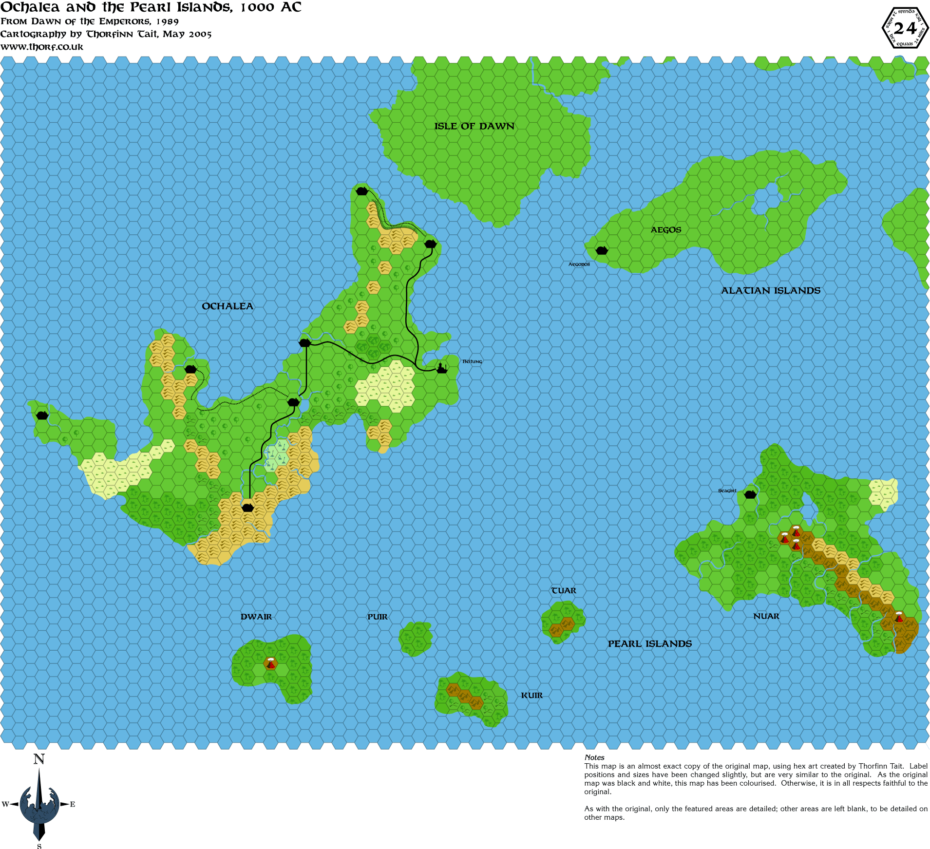
Replica Map - Ochalea and the Pearl Islands from Dawn of the Emperors
|
31 May 2005, 12:39 PM
|
|
Member
|
|
Join Date: Jan 2005
Location: Akita, Japan
|
|
Tomorrow
I'll post the updated version of the Alatians, Ochalea and the Pearl
Islands. The best coastlines were on the Isle of Dawn map, as were the
names of many of the settlements. Also many villages were marked on
that map too.
Following that, Thursday will be the Isle of Dawn map itself. I'm still
working on the updated version, but if I get it done in time it'll be
up on Friday. The Dawn of the Emperors Isle of Dawn map, while it is
the most detailed map available (other than the fragment shown on TM2),
unfortunately misses out most of the dominion boundaries and names. And
as far as I can see, the only source for them for 1000 AC is errata
published in Dragon Magazine. The version I have from the CD-ROM
archive is in black in white, too, though I seem to remember it was in
colour...
Any thoughts on other sources for the Isle of Dawn in AC 1000?
|
31 May 2005, 07:47 PM
|
|
Member
|
|
Join Date: Jan 2004
Location: Italy
|
|
Well,
of course the best one (bsides DotE and TM2) is the map you can find in
M5, Talons of Night adventure module. You've got a nice view of the
Thothian plateau too, with details on the aranea, elven and phanaton
settlements.
Oh and there was also a map in PWA 2 IIRC, although it was way too large as a scale for being useful to you, I think.
Btw, I'll second Traianus's question: how's your married life going?
|
1 June 2005, 12:03 AM
|
|
Member
|
|
Join Date: Jan 2005
Location: Akita, Japan
|
|
Hi Marco
Funny,
I've been whiling away the hours this evening reading through your
"author page" at the Vaults. I don't think I ever noticed that you
posted the results of the Alignment Project! That was way back in
1998... Anyway I'm glad, because I had thought it had been lost on one
of my old dead hard drives.
I also noticed that you compiled a list of Mystaran Universities a long
time ago, which coincidentally I had been working on lately. I have at
least one that you overlooked, so I'll probably post a revised version
- eventually.
Anyway, yes I have a number of maps from M5 to work with. The Valley of
the Dawn map is rather nice, giving an awful lot of detail in huge 24
mile hexes. More than enough to easily make an 8 mile per hex map of
that area. Unfortunately the Lands of the Aranea map suffers from two
curses: a horrible 3 mile per hex scale (no!! I can see the nightmares
starting already!!) coupled with hexes turned on their sides, the bane of all mappers. Madness I tell you!!       
Ahem...
The Poor Wizard's Almanac map does actually give the main information
I'm interested in, which is to say the borders, but unfortunately it
doesn't really solve the problem since I'm primarily interested in info
for 1000 AC - for now.
Still, I might be able to put something together...
Married life is very good.
Thank you for asking! With any luck the rest of this year will be a lot
less eventful than the first half has been. The big goal for now is to
save up for going home to Orkney next year to have another wedding
there.
|
1 June 2005, 12:42 AM
|
|
Member
|
|
Join Date: Jan 2004
Location: Italy
|
|
Hi there Thorf, ole pal!
Actually the borders in PWA are pretty useful, since they have not changed from 1000AC, you can safely assume they're the same!
The Alignment project, yes I finished it and have been using it through
all these years! I revised it a bit and generally it is always well
accepted by players
As for double marriage, go for it! I'm going to get married again this June too, obviously to the same woman :p
After the first civil marriage was held in my town's hall, the most
important ceremony (the religious marriage) is planned for 19th of
June. Unfortunately we already had our honeymoon (a 1-week trip to
Yucatan - Mexico, whoohoo!), so this time the great lunch after the
ceremony will be our only solace. :p
|
1 June 2005, 01:58 PM
|
|
Member
|
|
Join Date: Jan 2005
Location: Akita, Japan
|
|
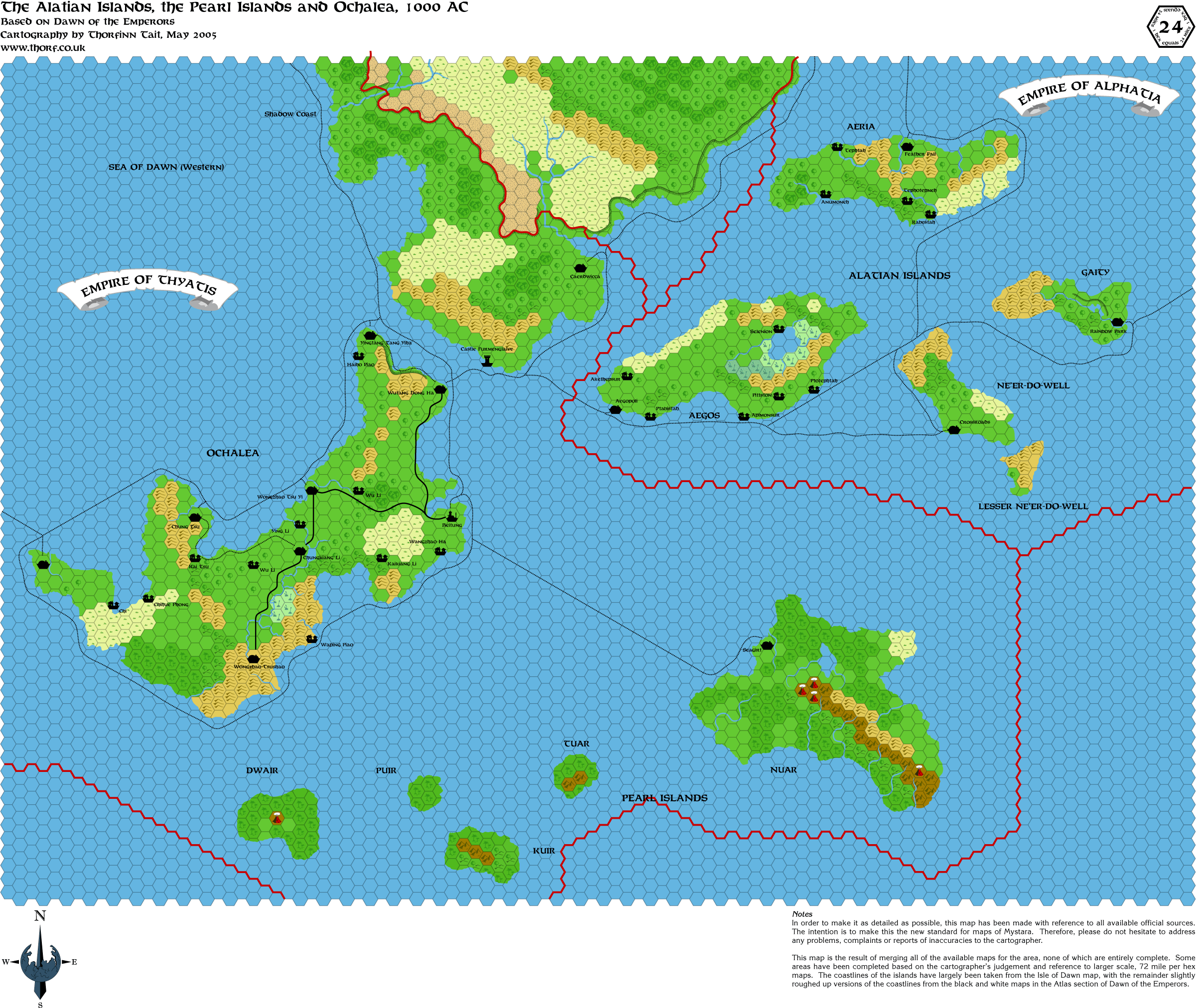
Updated Map - Ochalea, the Pearl Islands and the Alatian Islands
|
1 June 2005, 03:12 PM
|
 |
Member
|
|
Join Date: Jun 2005
Location: Uruguay
|
|
Absolutely
stunning work! And no doubt it will prove very useful to all
concerned... now the question is if you intend to make updated maps for
1010 and beyond?
RPGpundit
|
1 June 2005, 05:24 PM
|
|
Member
|
|
Join Date: Jan 2005
Location: Akita, Japan
|
|
Quote:
|
Originally Posted by DM
Actually the borders in PWA are pretty useful, since they have not changed from 1000AC, you can safely assume they're the same!
|
Ah, well that is very good to know! I thought that maybe with the
sinking of Alphatia and the changing empires the borders had been moved
around a bit.
Quote:
|
The Alignment project, yes I finished it and have been using it through
all these years! I revised it a bit and generally it is always well
accepted by players
|
Have you posted the revised version recently? I'd love to see what your current version is like.
Also I'm very glad to hear that you've been putting it to good use.
Quote:
As for double marriage, go for it! I'm going to get married again this June too, obviously to the same woman :p
After the first civil marriage was held in my town's hall, the most
important ceremony (the religious marriage) is planned for 19th of
June. Unfortunately we already had our honeymoon (a 1-week trip to
Yucatan - Mexico, whoohoo!), so this time the great lunch after the
ceremony will be our only solace. :p
|
Hehe, we're both double marriage guys then it seems... When was your
civil marriage, though? A few months ago, a year ago or what? Also,
what is your wife's name?
Wow, Mexico. Was it more like the Savage Coast, the Azcan Empire or what?
As for us, we're not likely to be honeymooning until next year, when
we're thinking of going somewhere on the way home from Orkney to Japan.
Somewhere in Europe would be nice, but if we make it America then we
can have a round the world trip at the same time.
Quote:
|
Originally Posted by RPGpundit
Absolutely
stunning work! And no doubt it will prove very useful to all
concerned... now the question is if you intend to make updated maps for
1010 and beyond?
|
Thanks.
And the answer is yes. But not until I have most of the maps laid down
for 1000 AC. After that, I plan on making quite a lot of different
versions to show various different stages, obviously including the 1010
AC setting.
|
1 June 2005, 09:26 PM
|
|
Member
|
|
Join Date: Jan 2004
Location: Italy
|
|
First
a question about the maps: where did you get all thos Thothian sounding
names for those villages in the Alatians? I have never seen them
before!!
As for my private life, my wife's name is Federica, we married on the
8th of January (my birthday!) this year, and we had a great time in
Yucatan! It's more like Azca with lots of paradise island-like resorts
here and there actually; stunningly beautiful!
I even went to Chichen Itza (the Mouth of the Water Mage's Well in
Mayan) climbed atop the ziqqurat, visited a real tlachtli court and saw
a tlachtli game which included a fiery ball!
Hope you have a nice time with your wife while waiting for your
honeymoon, and be careful to choose something which both of you can
enjoy
Ah, and if you come to Italy, don't forget to let me know! I want to
shake hands with your wife and congratulate you both.. and offer you a
great tour of typical Italian tastes.. :p
|
1 June 2005, 09:36 PM
|
|
Member
|
|
Join Date: Jan 2005
Location: Akita, Japan
|
|
Quote:
|
Originally Posted by DM
First
a question about the maps: where did you get all thos Thothian sounding
names for those villages in the Alatians? I have never seen them
before!!
|
They are featured on the Dawn of the Emperors Isle of Dawn poster map - and nowhere else.
Wow, congratulations! I didn't realise it was quite so recent, although
I do remember you saying you were just back from your honeymoon in
January. Your trip sounds like it was wonderful - I'd love to see a
real ziggurat and meet some of the people there now.
Thanks for the invitation! I will definitely impose on your hospitality one of these days. There is so much in Italy that my wife and I want to see! As to when, unfortunately that is a little more vague.
|
2 June 2005, 09:29 AM
|
|
Member
|
|
Join Date: Jan 2005
Location: Akita, Japan
|
|
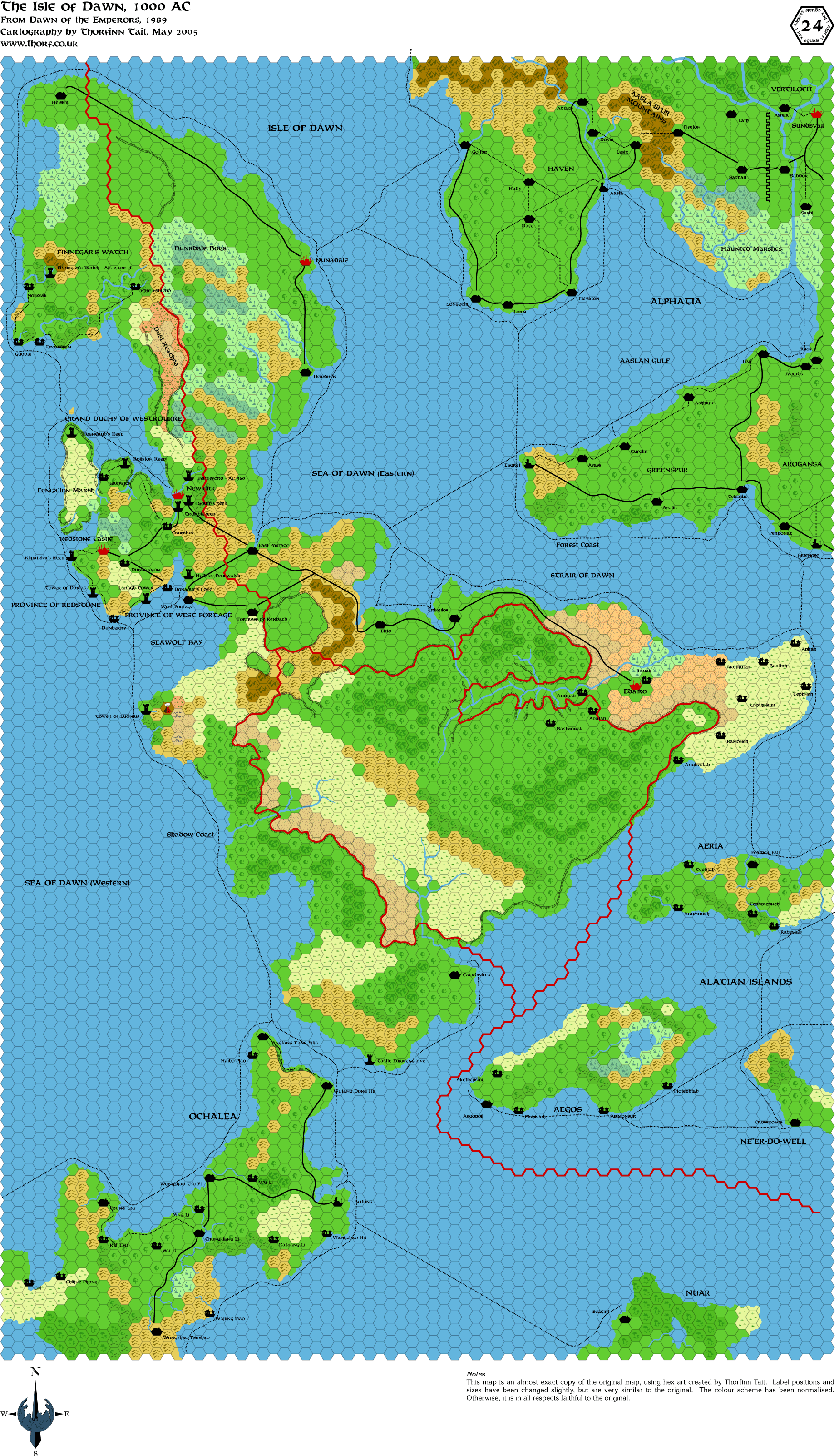
Replica Map - The Isle of Dawn
|
2 June 2005, 10:22 AM
|
 |
Member
|
|
Join Date: Apr 2004
Location: Denmark
|
|
A spelling error?
A beautiful map Thorf - as usual - but shouldn't the Strair of Dawn read as the Strait of Dawn?
:-) Jesper
__________________
Always cross a vampire, never moon a werewolf
|
4 June 2005, 12:49 AM
|
|
Member
|
|
Join Date: Jan 2005
Location: Akita, Japan
|
|
Quote:
|
Originally Posted by Spellweaver
A beautiful map Thorf - as usual - but shouldn't the Strair of Dawn read as the Strait of Dawn?
|
Thanks! I corrected my version, and it will get uploaded at my next upload session.
Today's map is a little special, since it deviates from my standard hex
maps. It was a lot of fun to do, and at 10 minutes to midnight local
time, I only just got it done for today!
The Isle of Dawn updated map will take a bit longer... I'll give you an
update on daily map postings after the weekend, when I see how much I
have got done.
|
4 June 2005, 12:51 AM
|
|
Member
|
|
Join Date: Jan 2005
Location: Akita, Japan
|
|
Replica Map - The Master Set Map
|
4 June 2005, 06:32 AM
|
|
Member
|
|
Join Date: Jan 2005
Location: Akita, Japan
|
|
 Fun with world maps
I've
been playing around with all the coast outlines I have done up until
now, to see how compatible they are with each other. Since the start of
my project, I've been very careful to try to keep everything
consistent, and to use the best sources for each part of the maps. As a
result, I now have an accurate-as-can-be coastline for the region from
the Great Waste to the Isle of Dawn and the Alatians.
Try and fit that area onto one of the two existing world maps (Master
Set and Hollow World/Cyclopedia), however, and it seems that the world
maps do not fit with the hex maps very well at all. For example, a
simple visual comparison will show that the Isle of Dawn is in fact
totally different on the two world maps - the proportions of each
section are completely different! 
I previously noticed this with Savage Coast maps, because I had to
rotate the line art map in order to fit it on to the hex maps. Both
maps nevertheless had straight up marked as north.
All this is very confusing, but the real problem is going to come when
I try to develop areas of Mystara that have not been officially mapped.
When the world maps are the only sources, and yet the world maps are
effectively incompatible, what is a cartographer to do?
This of course leads me to wonder what Thibault, Geoff and the others
have done to tackle this problem. It seems possible that they didn't
notice or just didn't worry about it. Possibly I am the first Mystaran
cartographer to date to attempt this level of accuracy between scales,
because up until now I don't think anyone else has had access to such a
flexible mapping system.
In any case, if anyone has any comments or advice about this situation, I'd love to hear them.
|
5 June 2005, 12:36 AM
|
|
|
Mapping the Edge!
Hi, new to the Community. The maps are excellent work.
When mapping a globe, remember that the surface area you projecting as
a flat map, is curving away and outwards the further north from the
equator you travel. Due to a globe curving away from the viewer in two
directions This might lead you to create a greater surface area further
north then what really is. Placing all the maps together are more
likely to create a tube then a globe if projected if not careful and
not compensating for.
How to compensate using the Hex system, will need some creative
thinking and may not be possible to eliminate entirely. The problem
will be even greater at the poles with it folding in on itself leading
to the hollow world.
|
|
|