Thorf's Secret Project: Stage One
A recreation of the Mystara Message Board thread that started the Atlas of Mystara project, with restored links and images.

15 June 2005, 21:30:18
|
|
|
Join Date: Feb 2005
Location: Ontario, Canada
|
|
Quote:
|
I too have my own plans to for Alphatia in the WotI. It won't be destroyed. I love the place and I won't stand for it again in another campaign. It will just get torched real bad.
|
Although my campaign never made it to WotI (I probably wouldn't have run the adventure as it was written, anyway), I never would have sunk Alphatia, either. Instead, I would have had Sundsvall destroyed by the Doomsday machine, and the resulting political chaos (in a nation full of individualistic wizards, no less) would have provided ample fodder for many campaigns.
I did take some of my ideas, and extrapolated them into a rough timeline of sorts to parallel the post-WotI period (up to AC 1016). It should be on the Vaults if anyone wants to mine it for ideas.
Geoff
|
15 June 2005, 21:44:22
|
 |
|
|
Join Date: Jan 2005
Location: Akita, Japan
|
|
This one's a big one!
The updated version will be up tomorrow, although it's not a huge amount different. |
15 June 2005, 22:16:36
|
|
|
|
Join Date: Jan 2005
Location: Akita, Japan
|
|

Thanks Geoff for pointing me in the direction of the Alphatia gazetteers. I'm going to have a lot of fun checking them out. 
It just occurred to me last night that if I had posted each new map in a new thread, we would probably have at least 50 more threads, or at least 80 if every single variation went in a different thread. 
But it seems like a better idea to put everything together in one thread for now. I've also been thinking about how to organise the thread better. I'm considering editing the first post to be a main index post with links to all the maps, similar to Marco's Immortals thread. On the other hand, it might be a better idea to spend the time updating my web page, which I haven't done in months. Since all the maps lead back to my web page, and since I can use thumbnails more easily there, and it's more permanent, I'm currently leaning towards my web page rather than the boards.
Of course, should anyone else wish to do an index of maps for this thread, I would be happy to post it.   |
16 June 2005, 5:52:50
|
 |
|
|
Join Date: Apr 2004
Location: Denmark
|
|
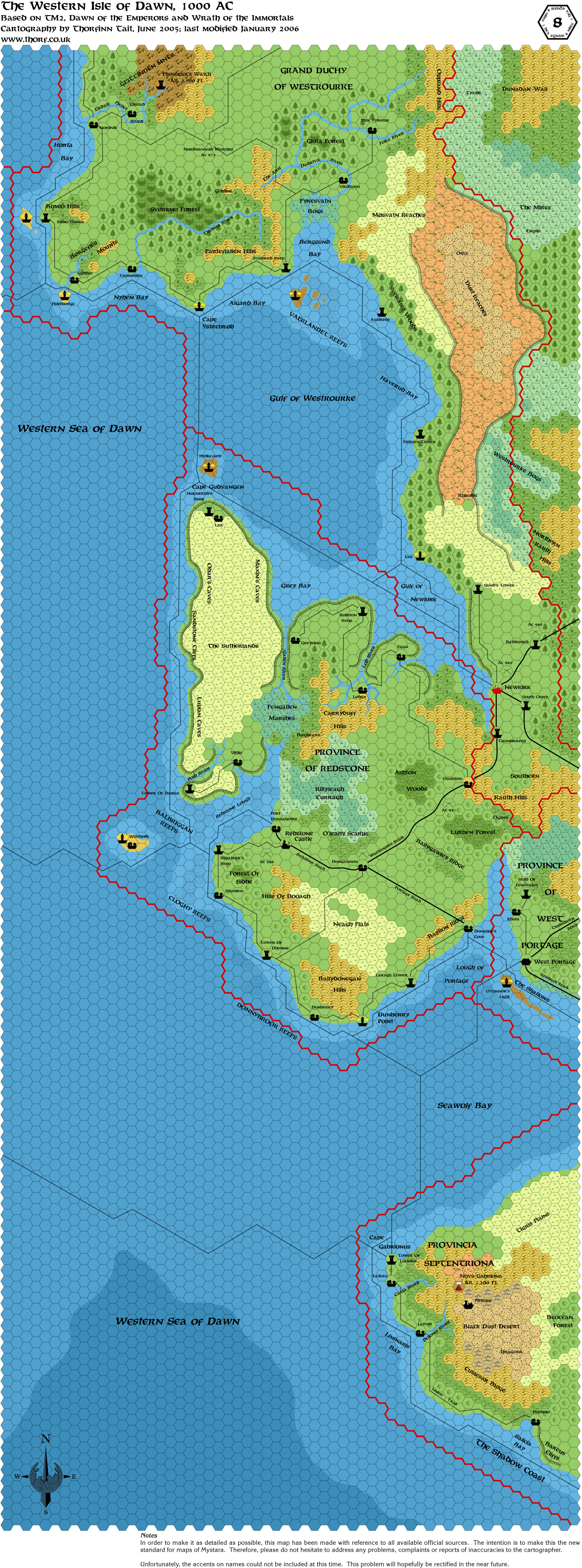
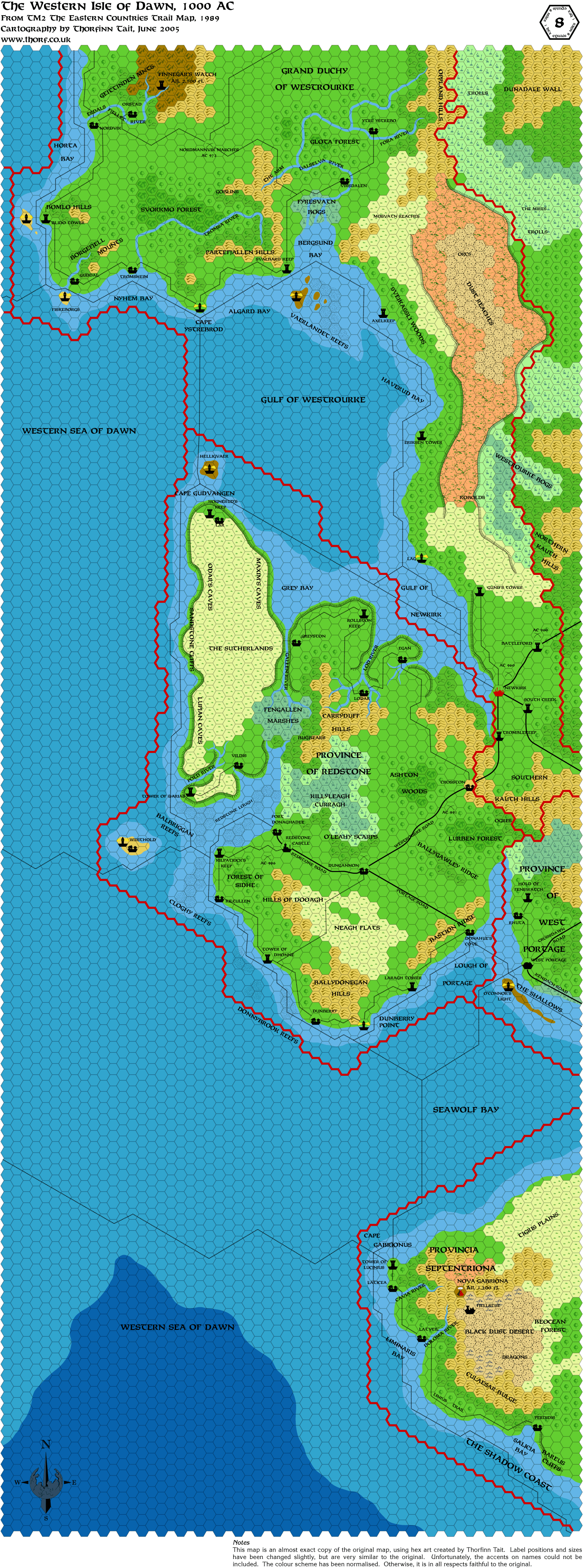
A beautiful map of the western Isle of Dawn, Thorf!
I never saw so many place-names and such detail before. Suddenly I want to place more adventures in those reaches
I am curious about something, though:
Why did you include the Ostland colonies in the Grand duchy of Westrourke? (The border line on the map). From everything I have read, they are independent colonies under the crown of Ostland, but tolerated as allied by Thyatis?
Did I miss something?
And another question for all of you in general:
Is there somewhere where I can read more about all of these exciting new placenames on the map? Has anything official or unofficial been written, sort of like a gazeteer for the territories?
:-) Jesper |
16 June 2005, 5:54:47
|
|
|
|
Join Date: Apr 2004
Location: Denmark
|
|
Just noticed: the city of West Portage seems to be missing on the map 
Other than that, fantastic work!   
:-) Jesper |
16 June 2005, 6:53:49
|
 |
|
|
Join Date: Sep 2003
Location: Malpheggi Swamp near the Darokin border
|
|
Quote:
Of course, should anyone else wish to do an index of maps for this thread, I would be happy to post it. |
I'll try to set that up tonight, if I can.
EDIT: Unless someone beats me to it.
|
16 June 2005, 9:32:40
|
|
|
|
Join Date: Jan 2005
Location: Akita, Japan
|
|
Quote:
A beautiful map of the western Isle of Dawn, Thorf!
I never saw so many place-names and such detail before. Suddenly I want to place more adventures in those reaches |
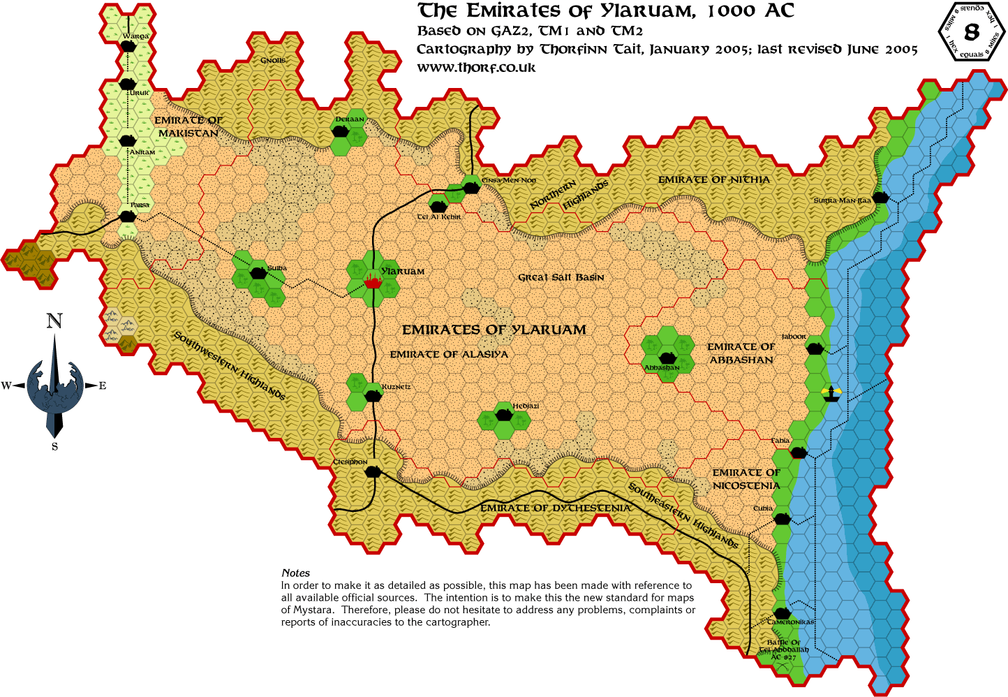
Yeah, TM2 was wonderful for providing the placenames. Unfortunately there is little to no information about most of them, so the majority are left entirely to your imagination.
Quote:
|
I am curious about something, though:
Why did you include the Ostland colonies in the Grand duchy of Westrourke? (The border line on the map). From everything I have read, they are independent colonies under the crown of Ostland, but tolerated as allied by Thyatis?
Did I miss something?
|
There are three things to note about this situation. First, TM2 does indeed show villages and settlements with Antalian-style names, and they are indeed placed geographically within the borders of the Grand Duchy of Westrourke.
Next, GAZ7 describes seven Ostland colonies (three established, four in planning stages) on the Isle of Dawn. It seems to make sense for the settlements on TM2 to be those colonies. Aside from these colonies and a few fortifications, Westrourke seems to be largely unsettled. This could explain the real reason for the colonies to be allowed - not to cause problems for Alphatia, as hinted in GAZ7, but just to settle a previously unsettled region of the Isle of Dawn. Quite probably the colonies have to pay taxes to both Zeaburg and Newkirk.
Last, Dawn of the Emperors describes a line of signal towers maintained by the Archduke of Westrourke, stretching from Newkirk to Finnegar's Watch. These are of course marked on the map, and interestingly the Ostland colonies are in and around the area of Finnegar's Watch. This suggests a fair level of contact between the Ostland colonies and Newkirk; the colonies can't just be quietly getting away with existing on Thyatian territory, because the Thyatian soldiers and citizens stationed in the watch towers must have contact with the villages, and possibly even rely on them for some supplies.
All in all, it seems like an interesting concept, vaguely outlined across multiple sources and represented in the trail map. It could definitely do with a writeup, but unfortunately the Poor Wizard's Almanacs failed to provide any mention of the situation.
Quote:
|
Is there somewhere where I can read more about all of these exciting new placenames on the map? Has anything official or unofficial been written, sort of like a gazeteer for the territories?
|
I'd be interested in seeing that too!
Thanks for finding the error on the map, by the way. It looks like there's a lighthouse missing in the north too...
|
16 June 2005, 10:37:40
|
|
|
Quote:
... On the other hand, it might be a better idea to spend the time updating my web page, which I haven't done in months. Since all the maps lead back to my web page, and since I can use thumbnails more easily there, and it's more permanent, I'm currently leaning towards my web page rather than the boards.
Of course, should anyone else wish to do an index of maps for this thread, I would be happy to post it. |
Please, focus on the maps. I would be glad to help you to reorganize your website. These maps are so awesome, don't waste your time with just writing uninteresting lines of code... 
Would you mind telling me if your website is supporting php. Maybe it could be easier to deal with the thumbnails and everything.
Greetings.
Edit :
By the Way, i did both.
This link goes to My Website. It's not really nice right now, but i'll work on it. There are 3 directories 08/24/40 for each categories of maps. Enjoy.
And the list of every maps which where posted (i think) :
The ones with * are not hosted by Thorf, which explain why the links were previously dead.
The one with + was posted by Mah9.
legend
 Thorf's Secret Project : Stage One
 Scale 8 ( 45)
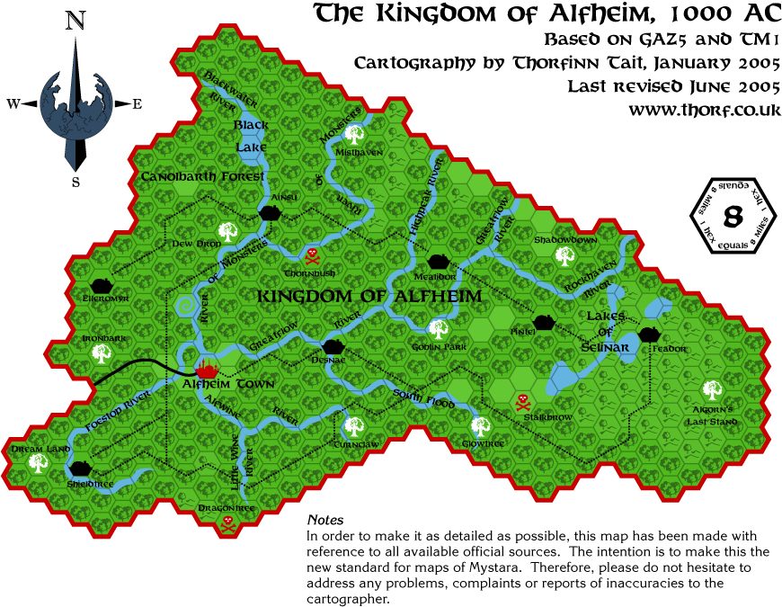
aengmor
alfheim
atruaghin-revised
atruaghin
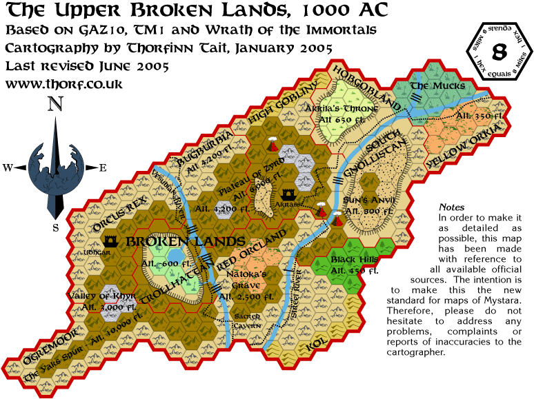
broken-lands-above
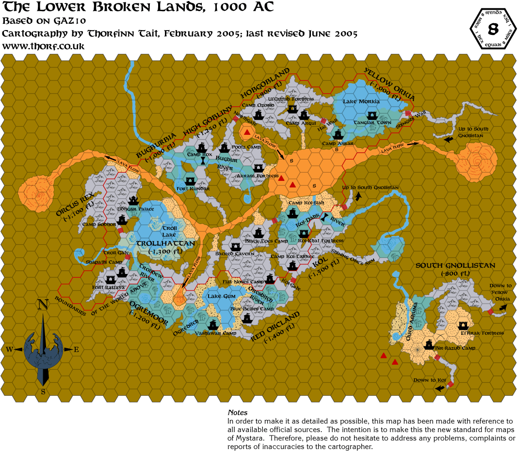
broken-lands-under
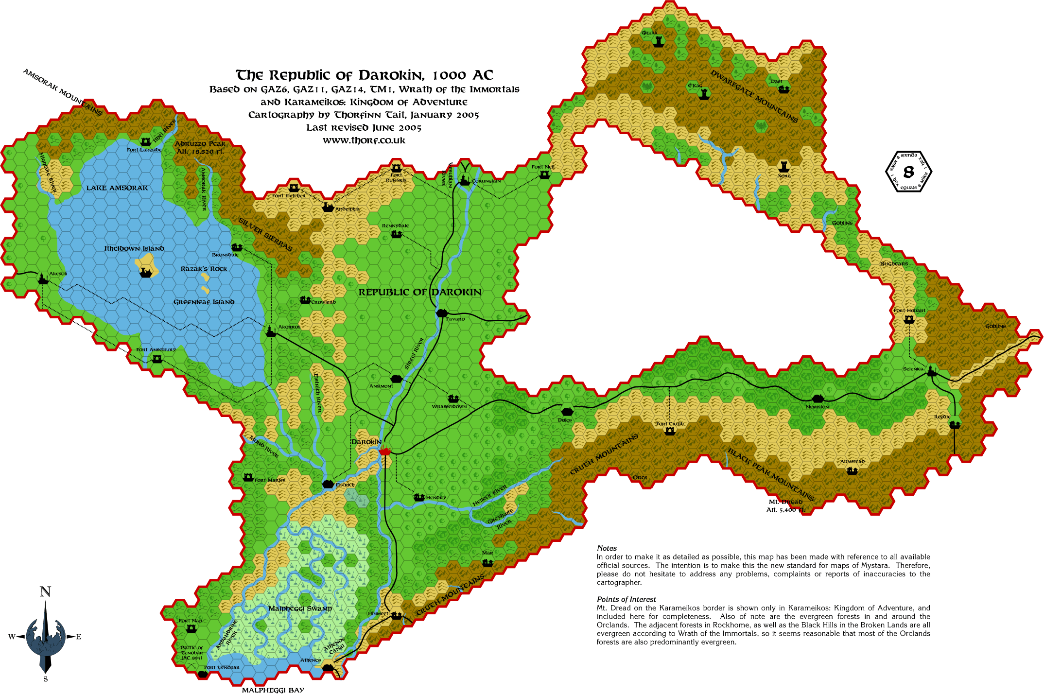
darokin
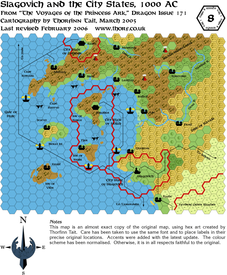
dragon171-slagovich
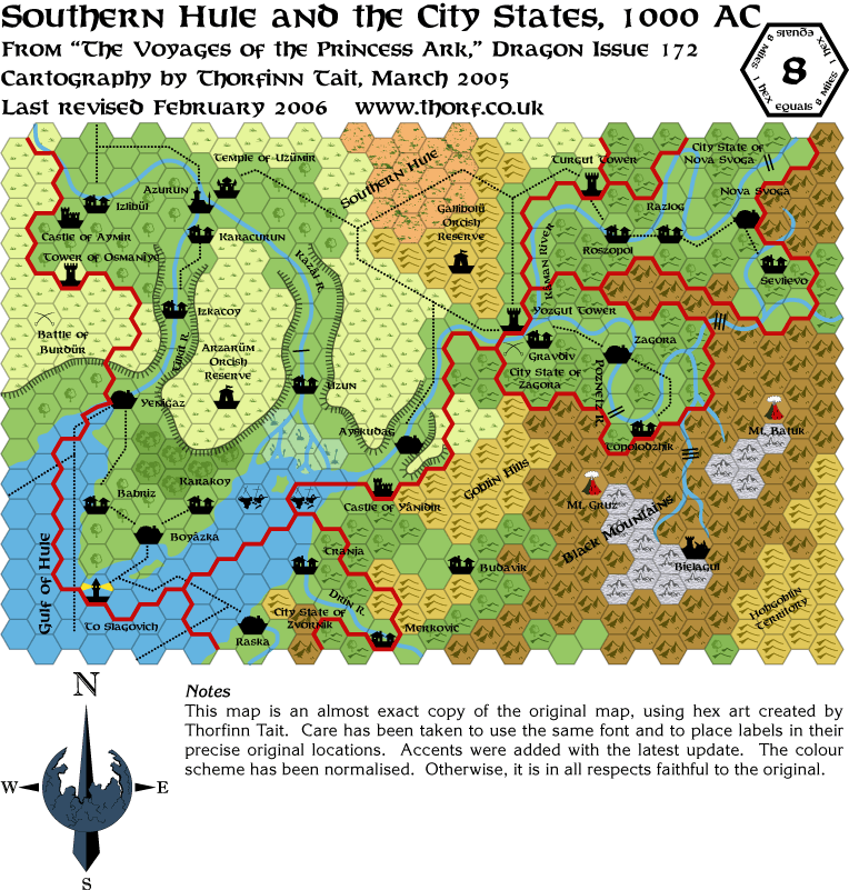
dragon172-southern-hule
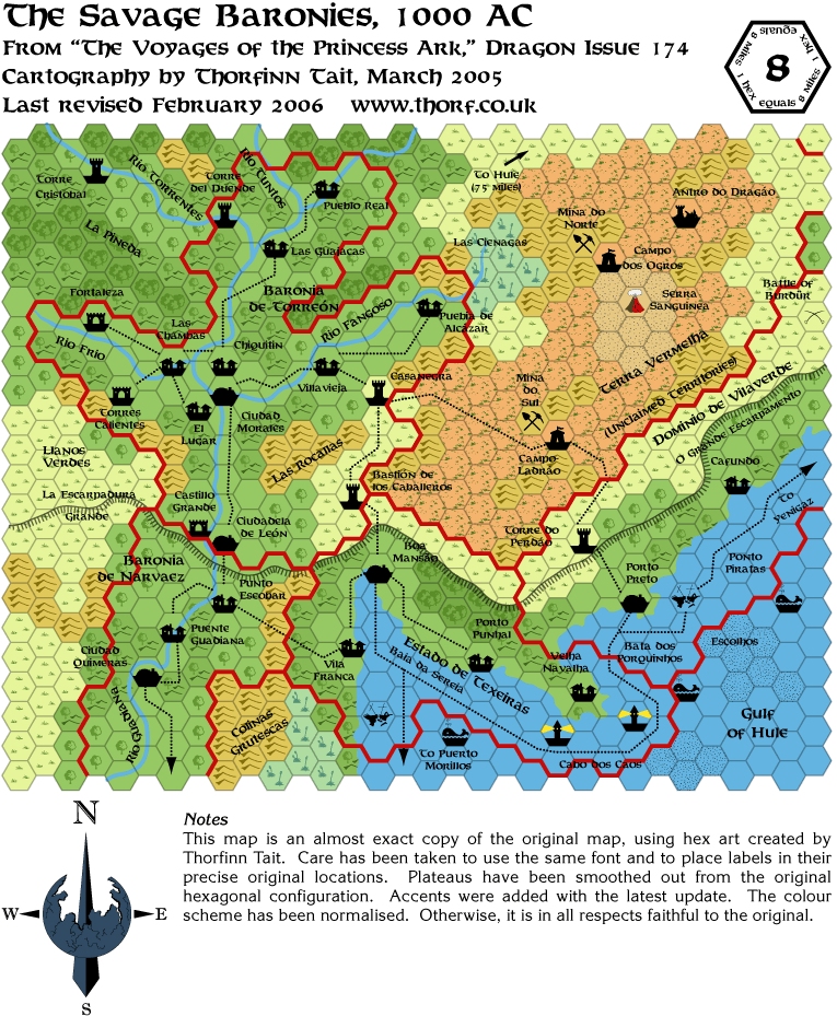
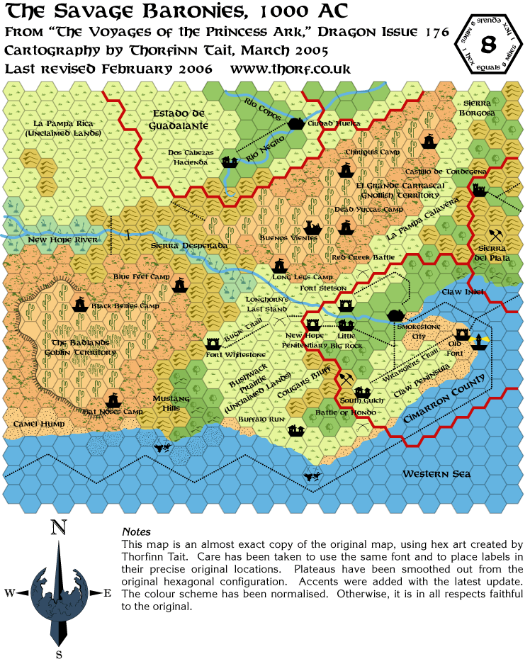
dragon174-savage-baronies
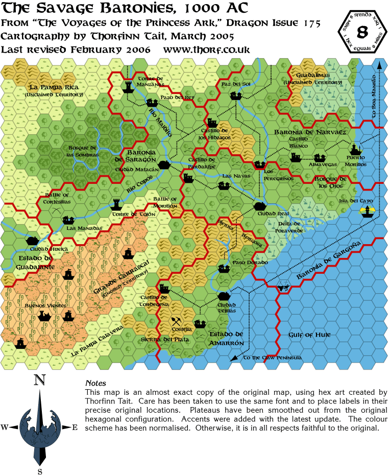
dragon175-savage-baronies
dragon176-savage-baronies
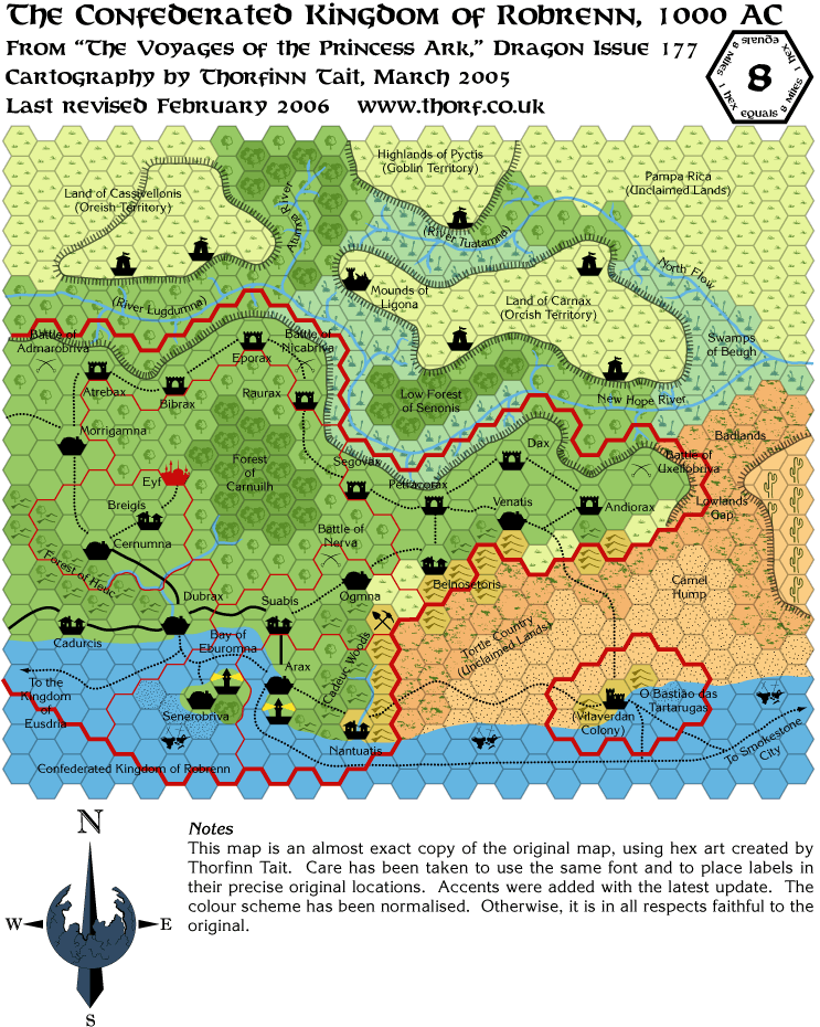
dragon177-robrenn
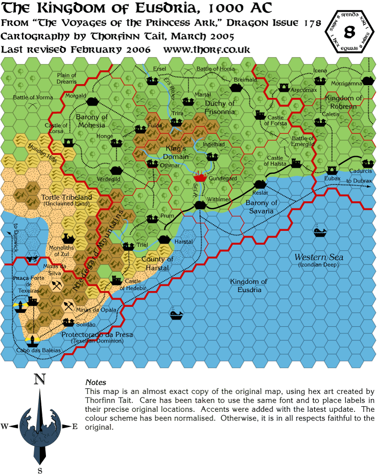
dragon178-eusdria
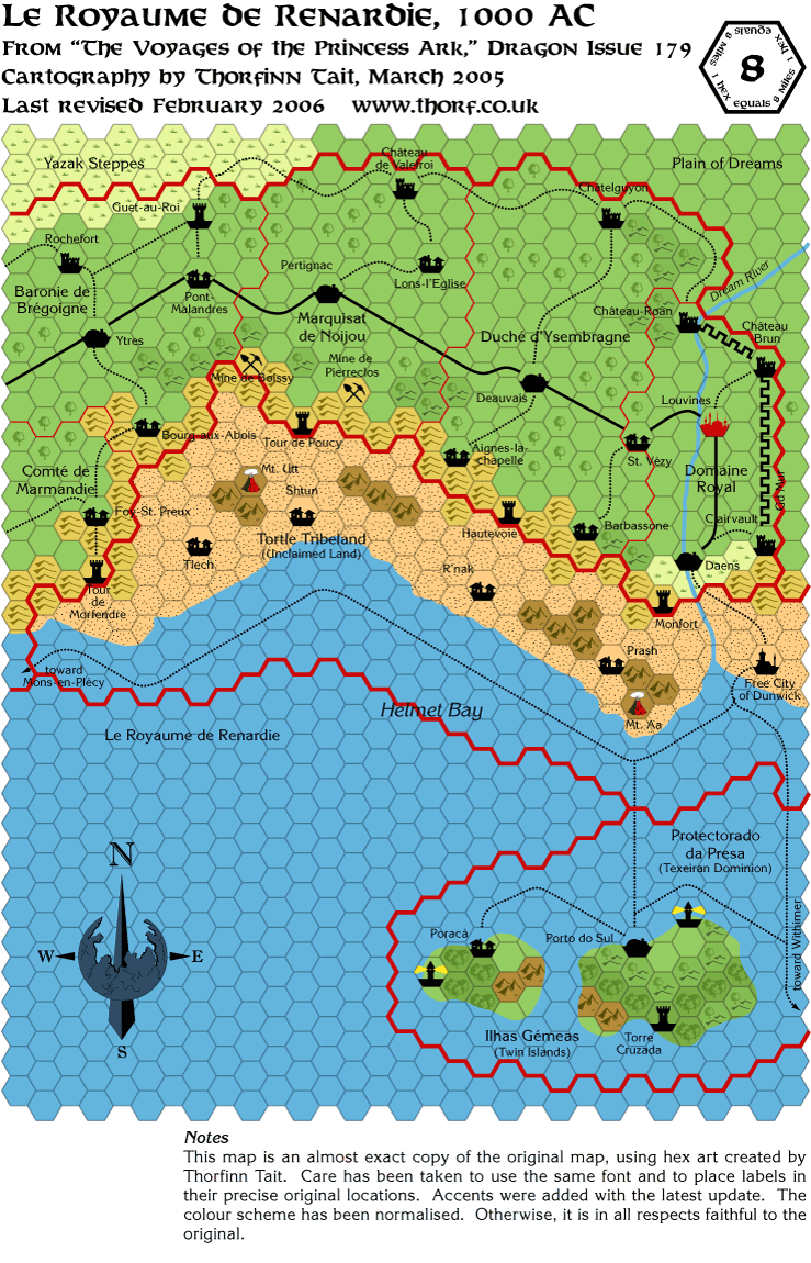
dragon179-renardy
dragon180-bellayne
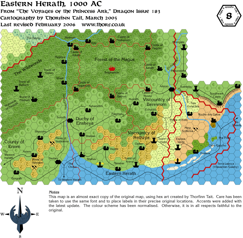
dragon183-eastern-herath
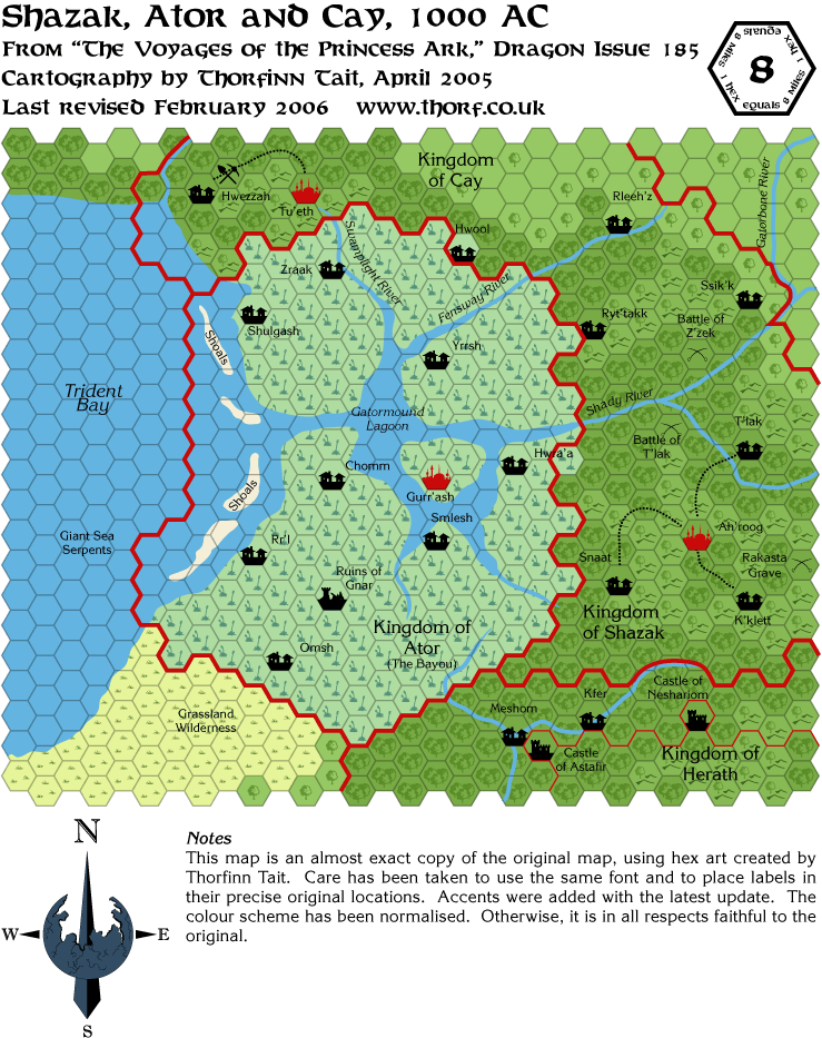
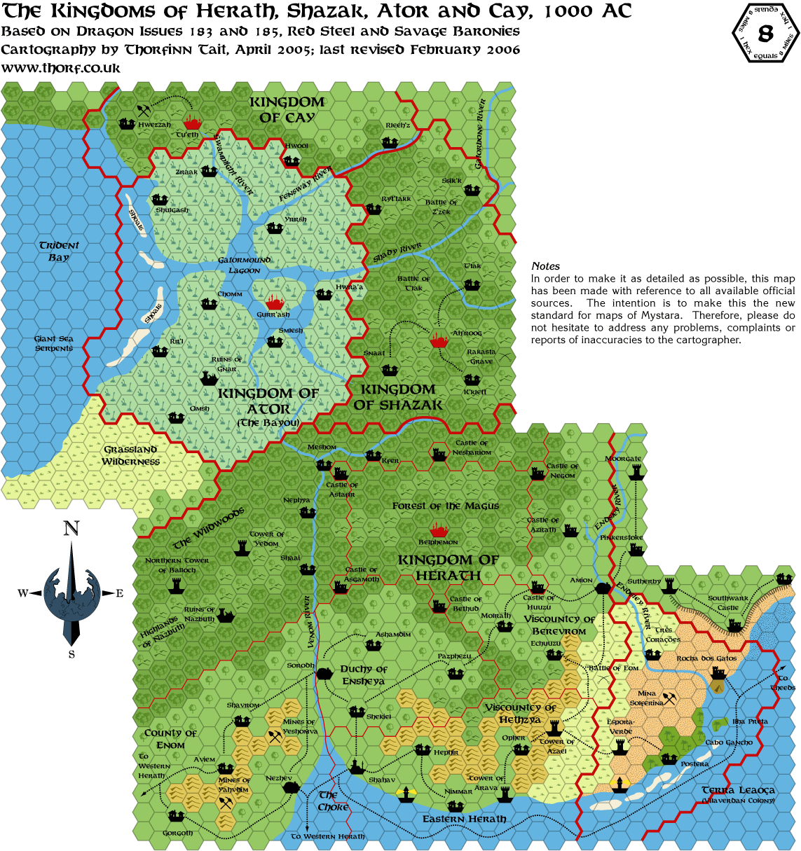
dragon185-shazak-ator-cay
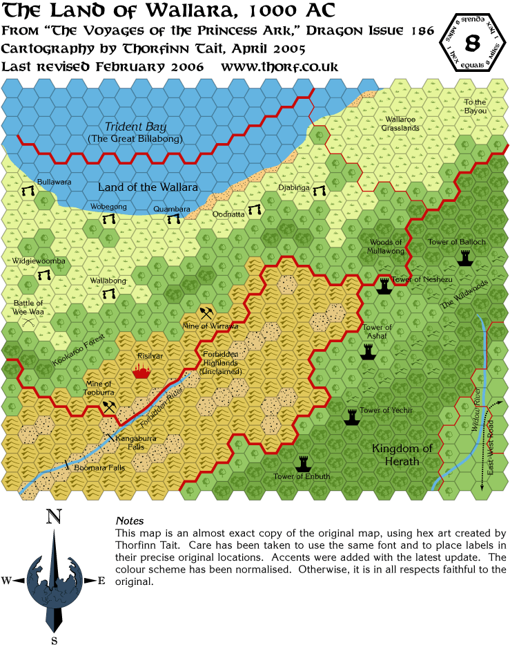
dragon186-wallara
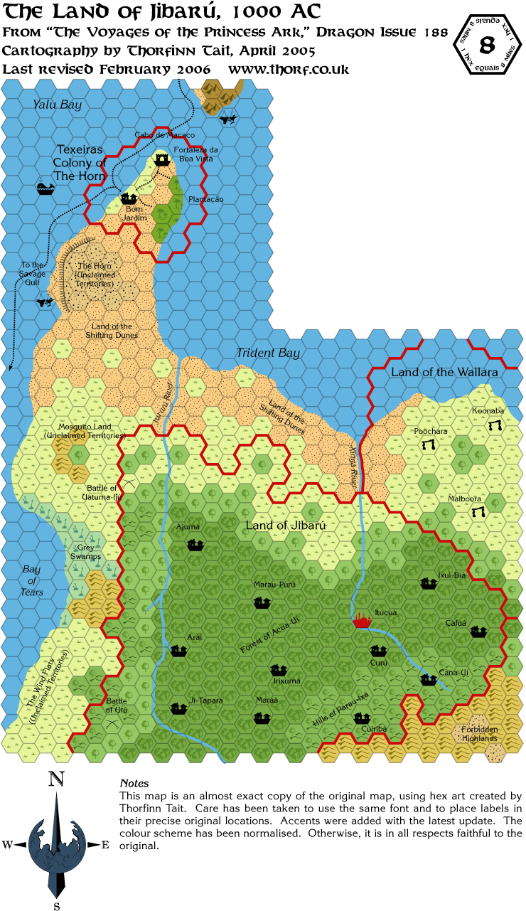
dragon188-jibaru
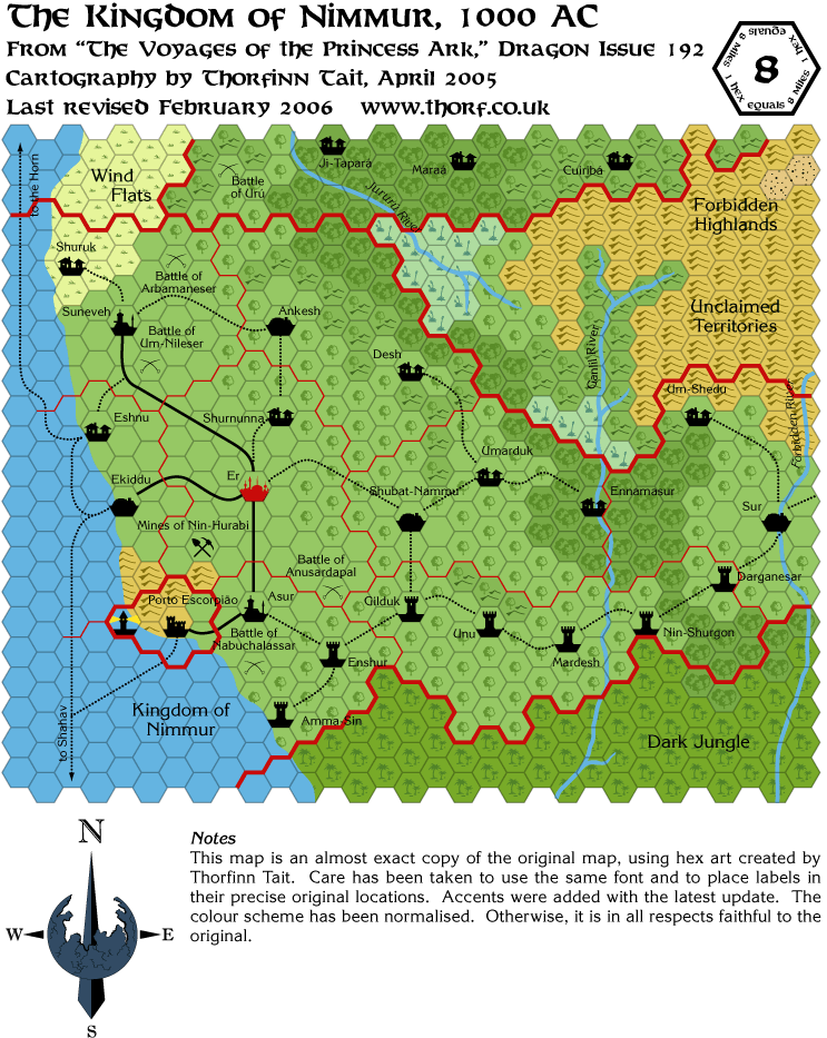
dragon192-nimmur
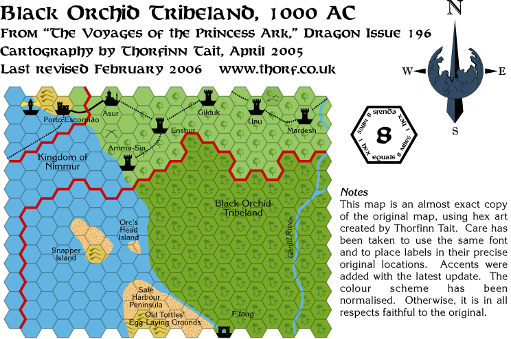
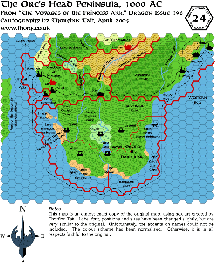
dragon196-black-orchid
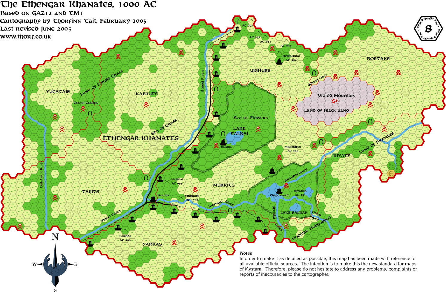
ethengar
five-shires
glantri-evergreen
gulf-of-hule
herath-shazak-ator-cay
hwr2-nithia-southern-region*
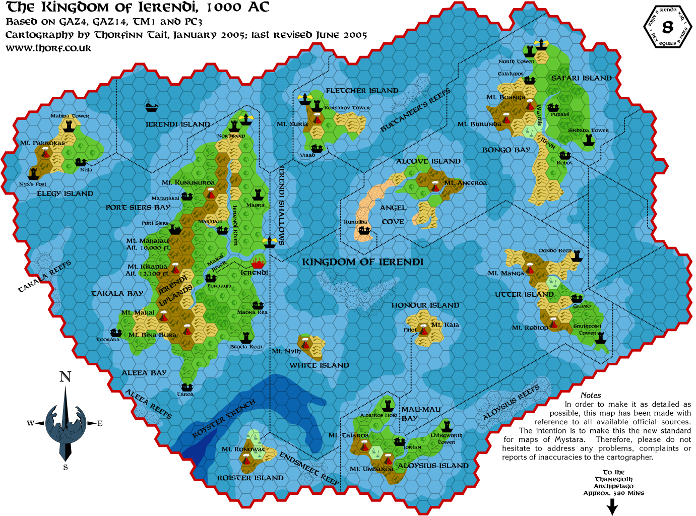
ierendi
isle-of-dawn-west*
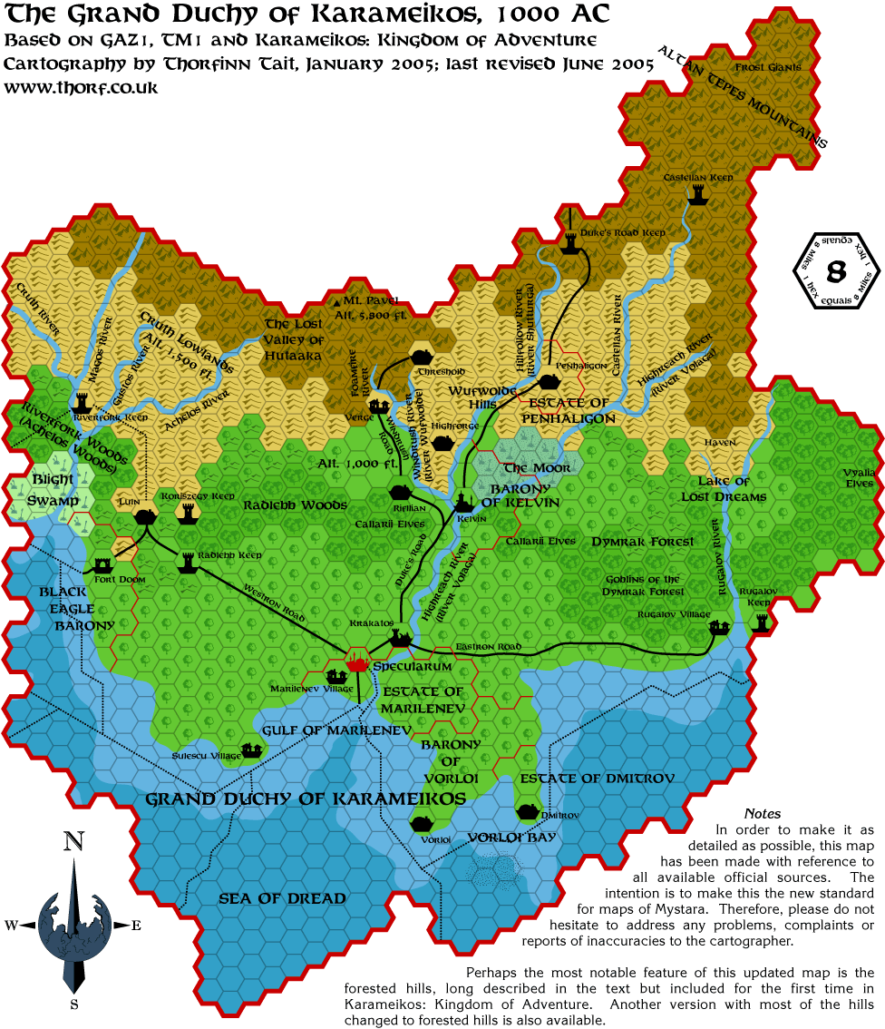
karameikos-forested-hills
karameikos-shaded-forests
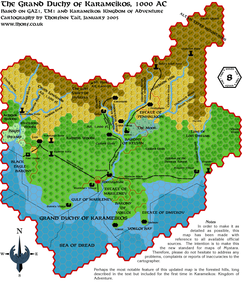
karameikos
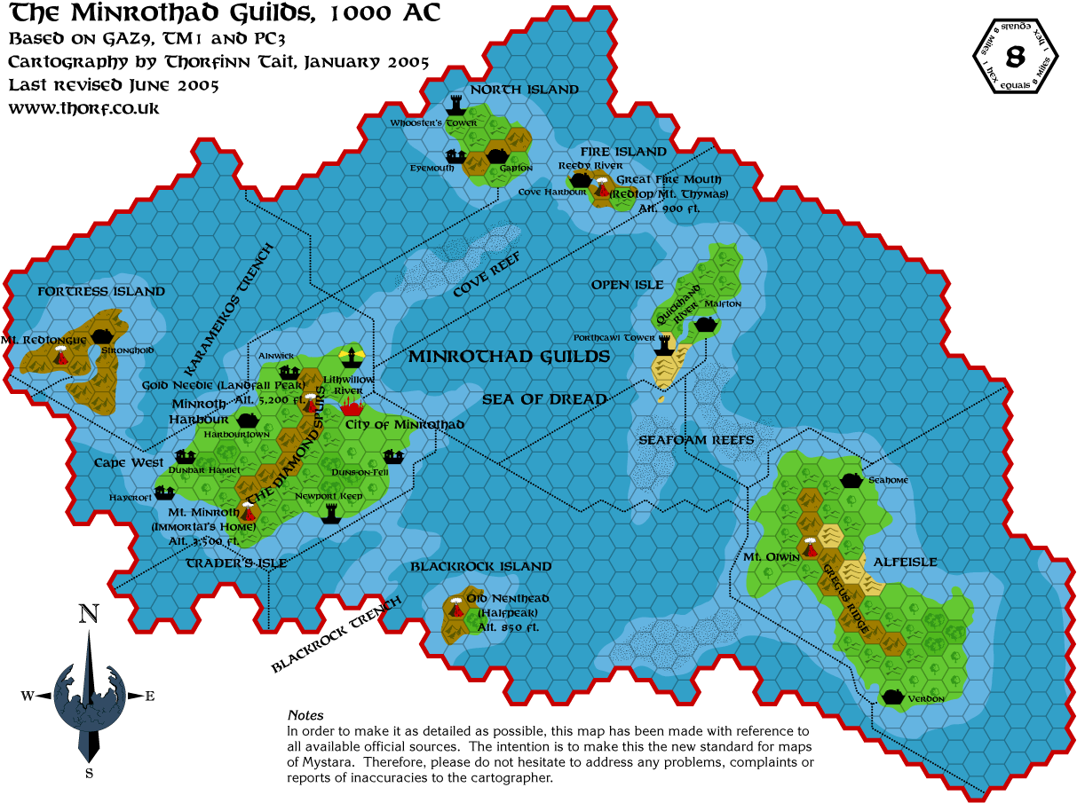
minrothad
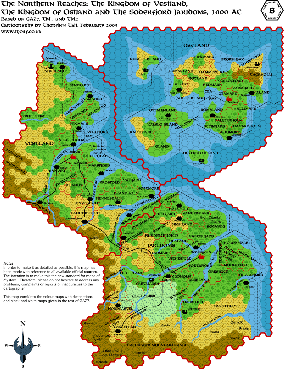
northern-reaches
orc's-head-peninsula
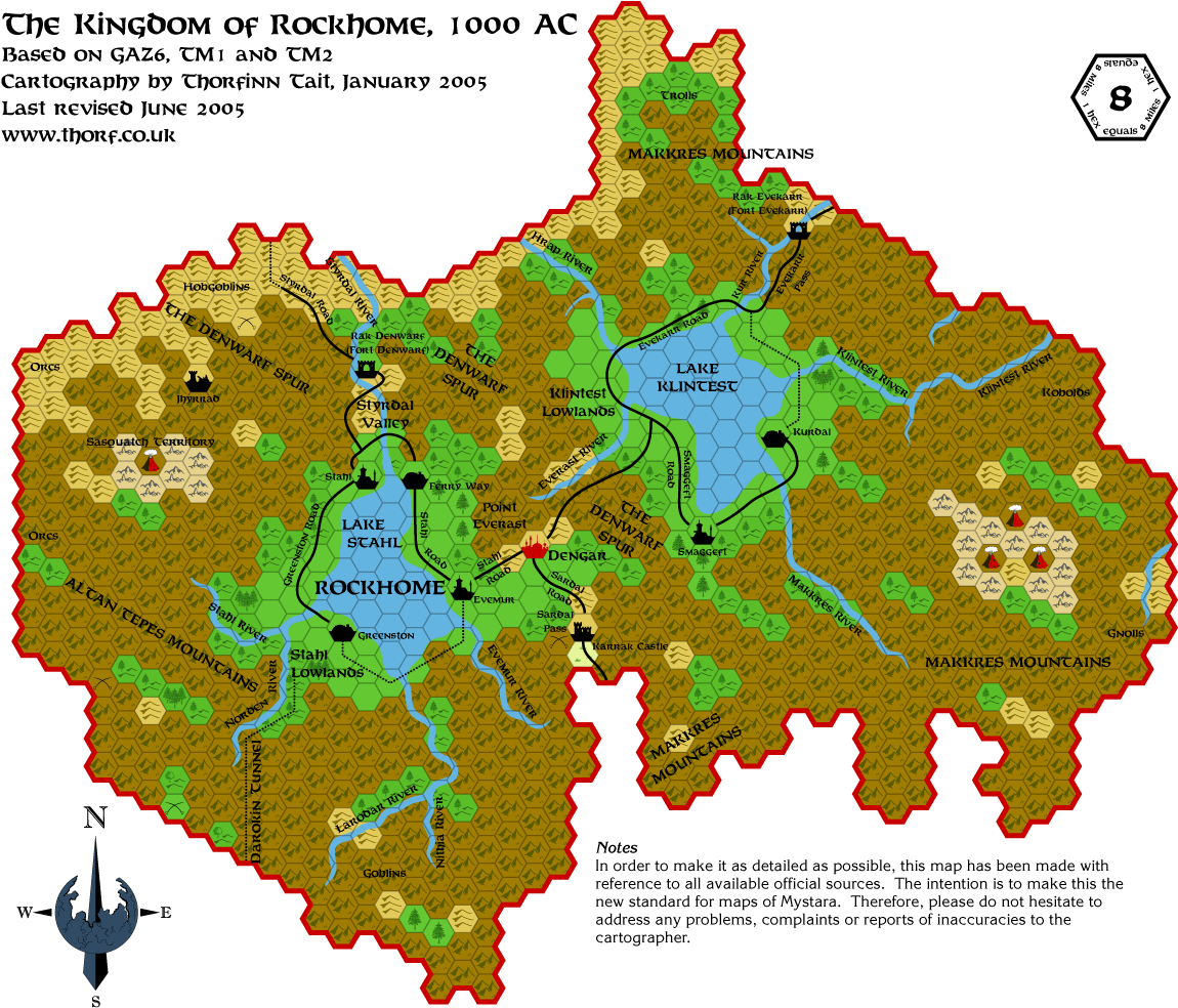
rockhome
savage-baronies
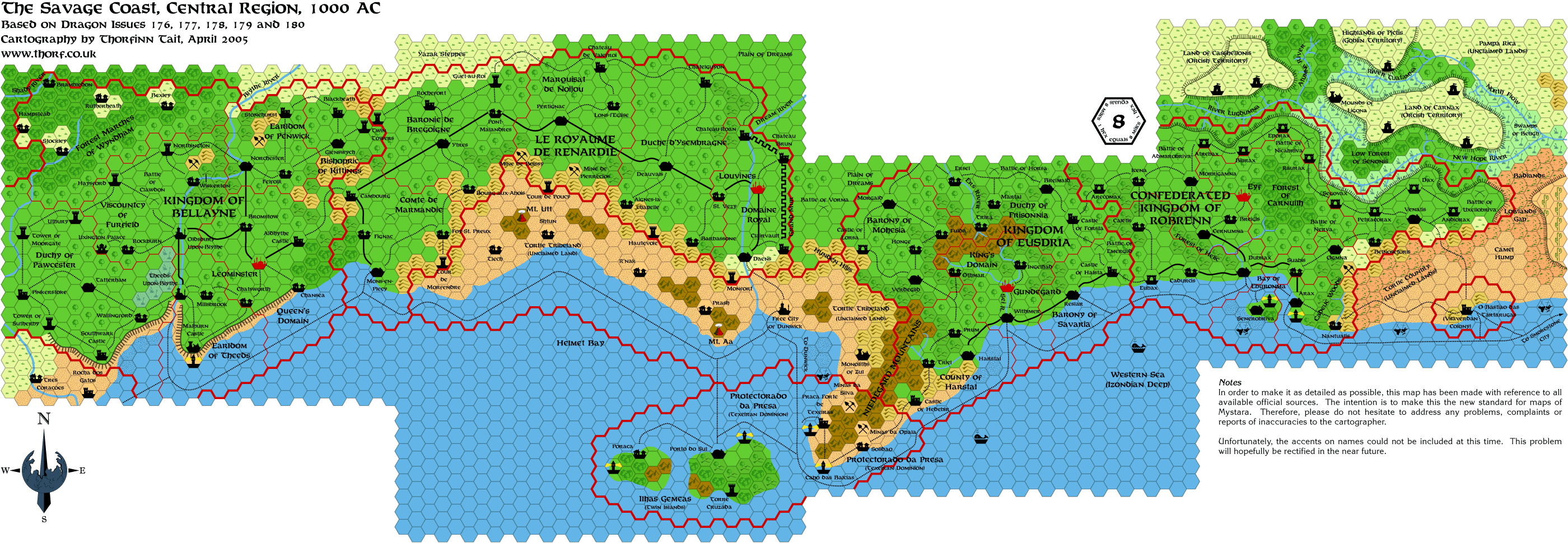
savage-coast-central
shadow-elves-cavern-walls
shadow-elves
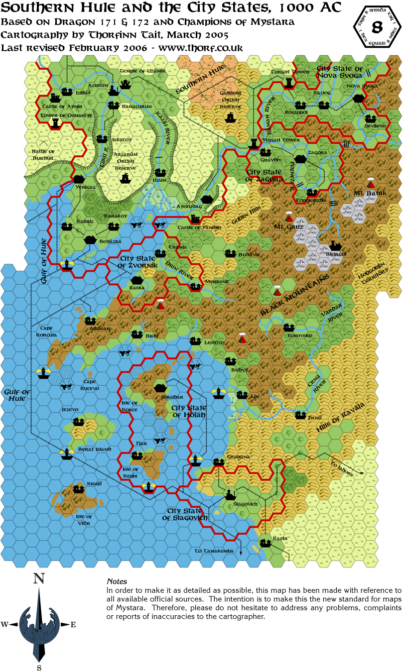
southern-hule-city-states
thyatis
tm2-isle-of-dawn*
ylaruam
Scale 24 ( 25)
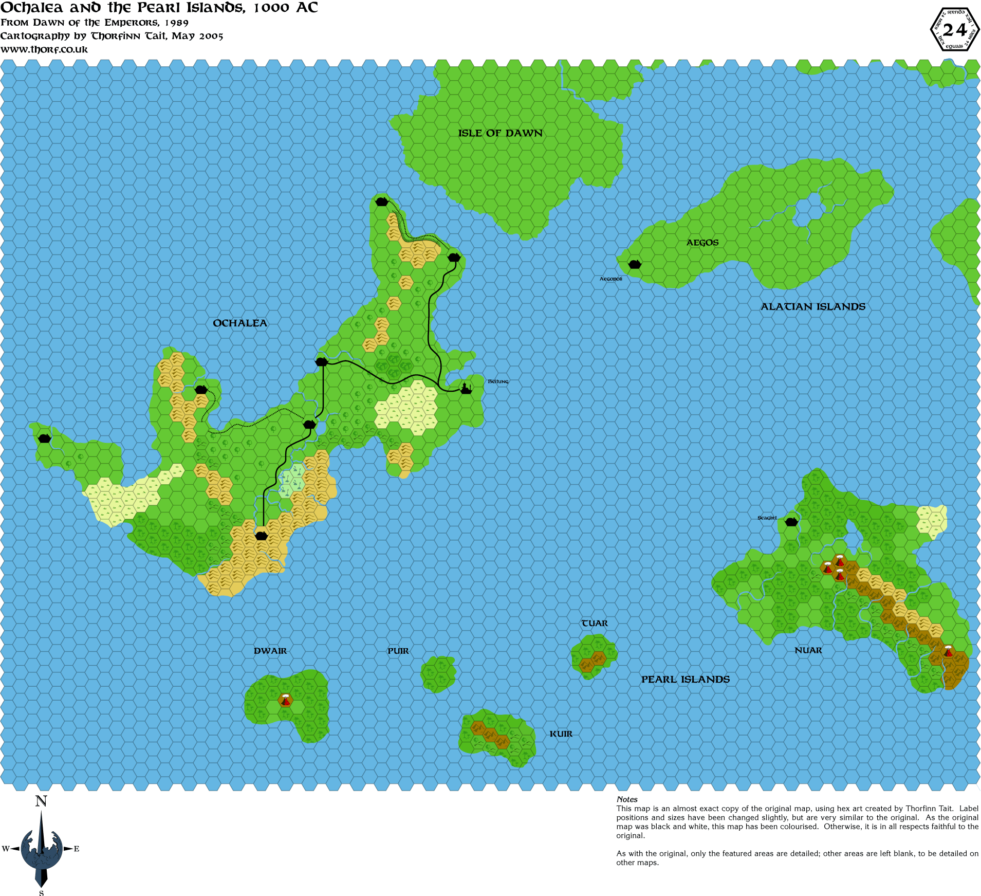
alatians-pearl-ochalea*
alphatia-deciduous*
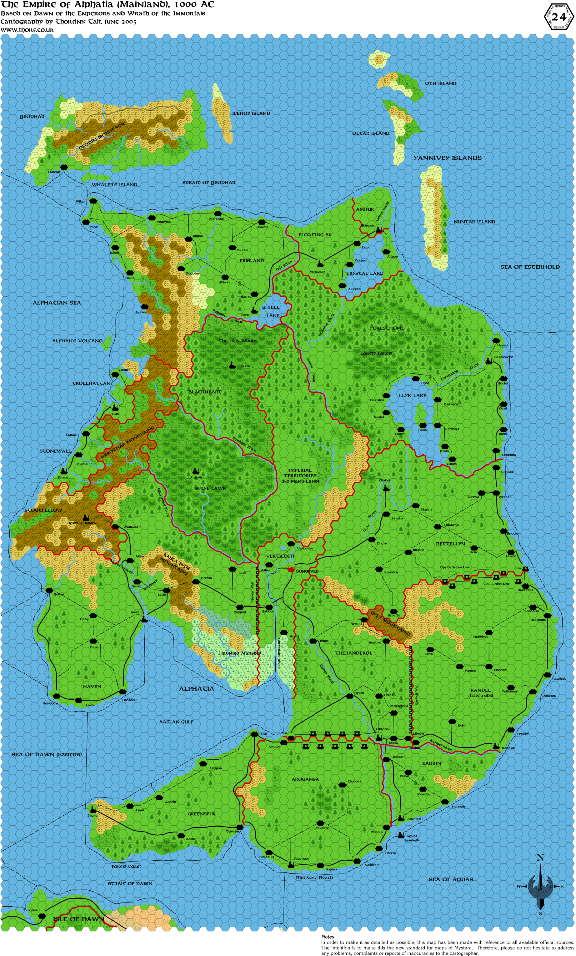
alphatia*
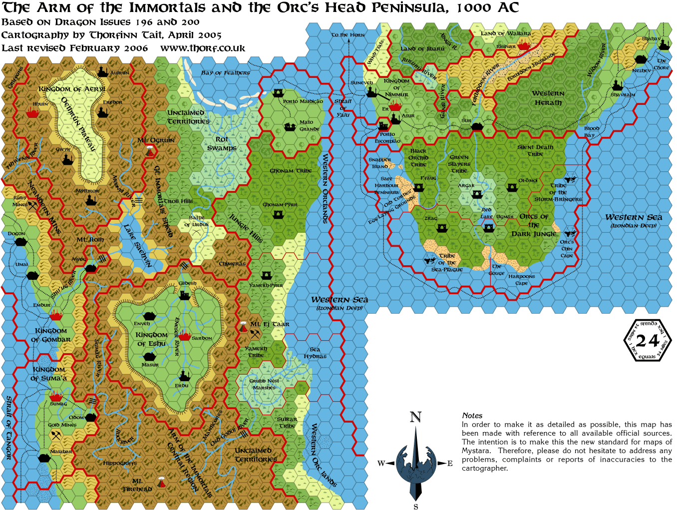
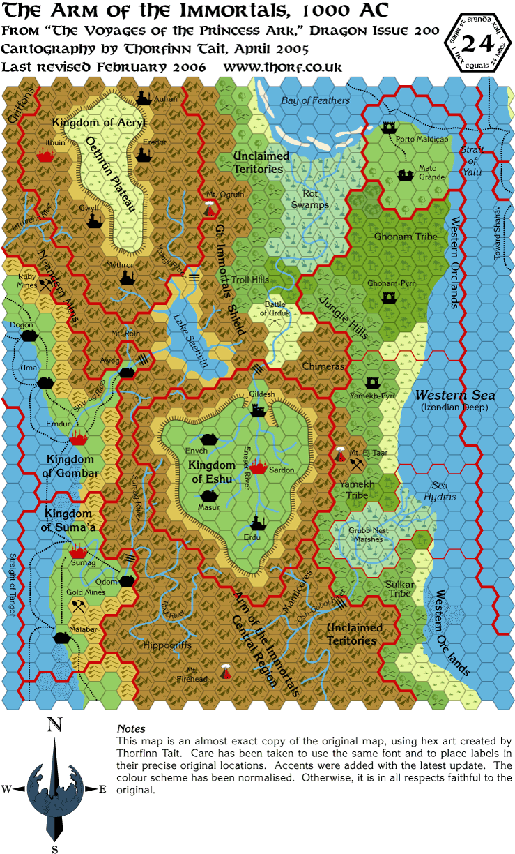
arm-immortals-orc's-head
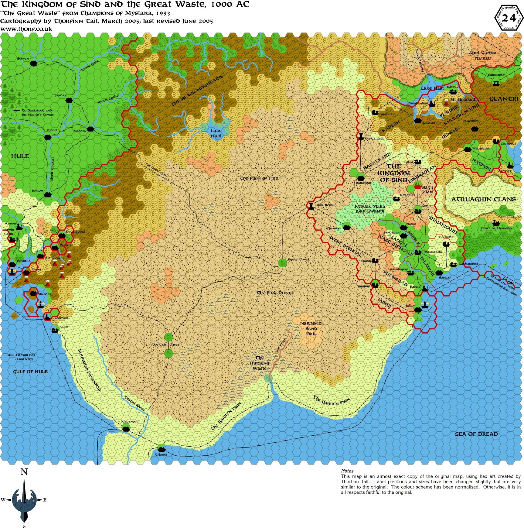
champions-great-waste
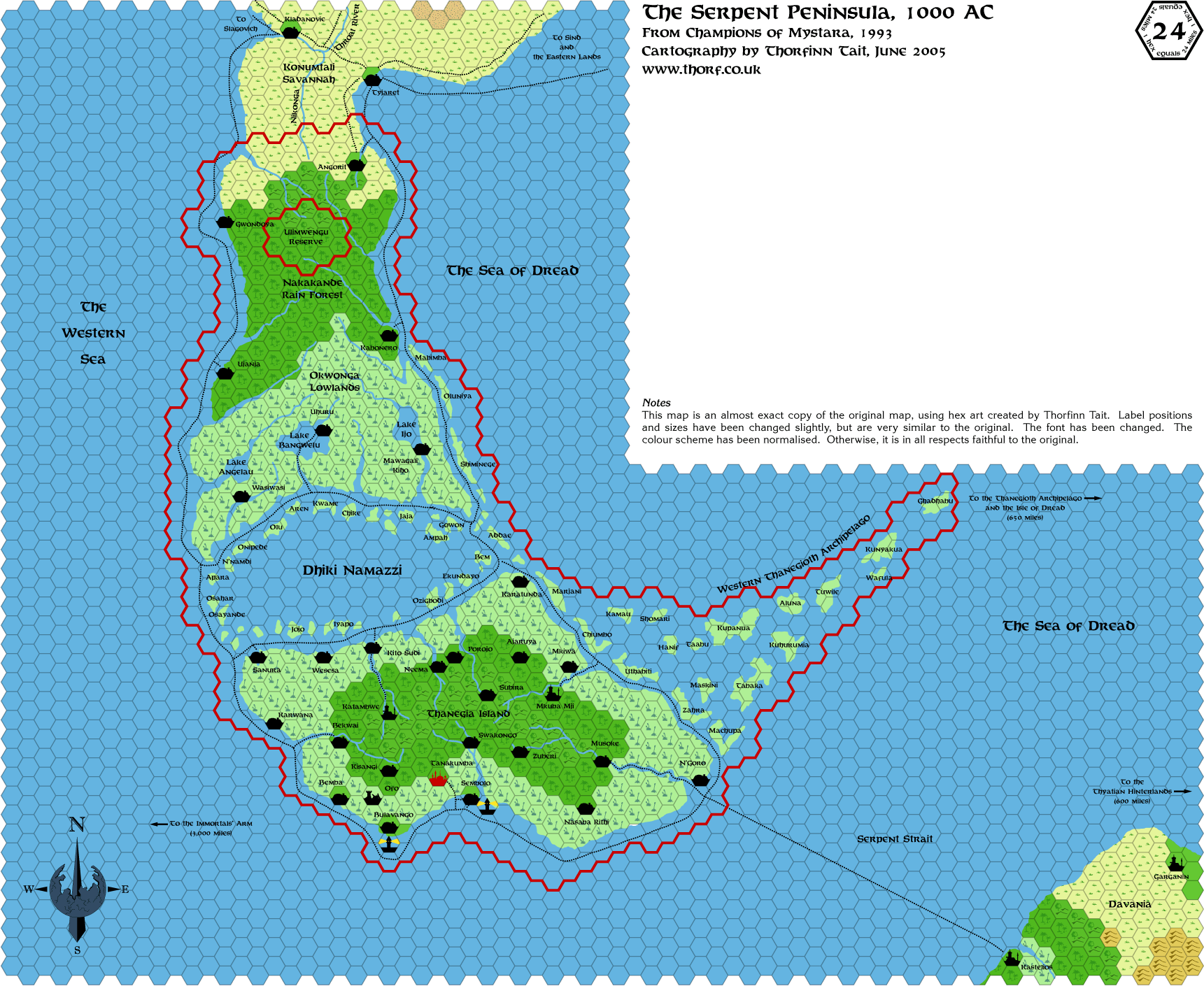
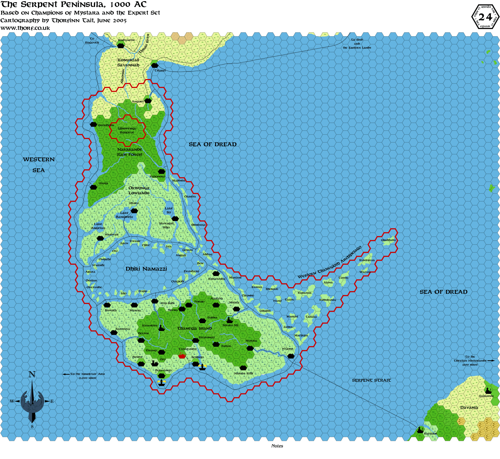
champions-serpent-peninsula*
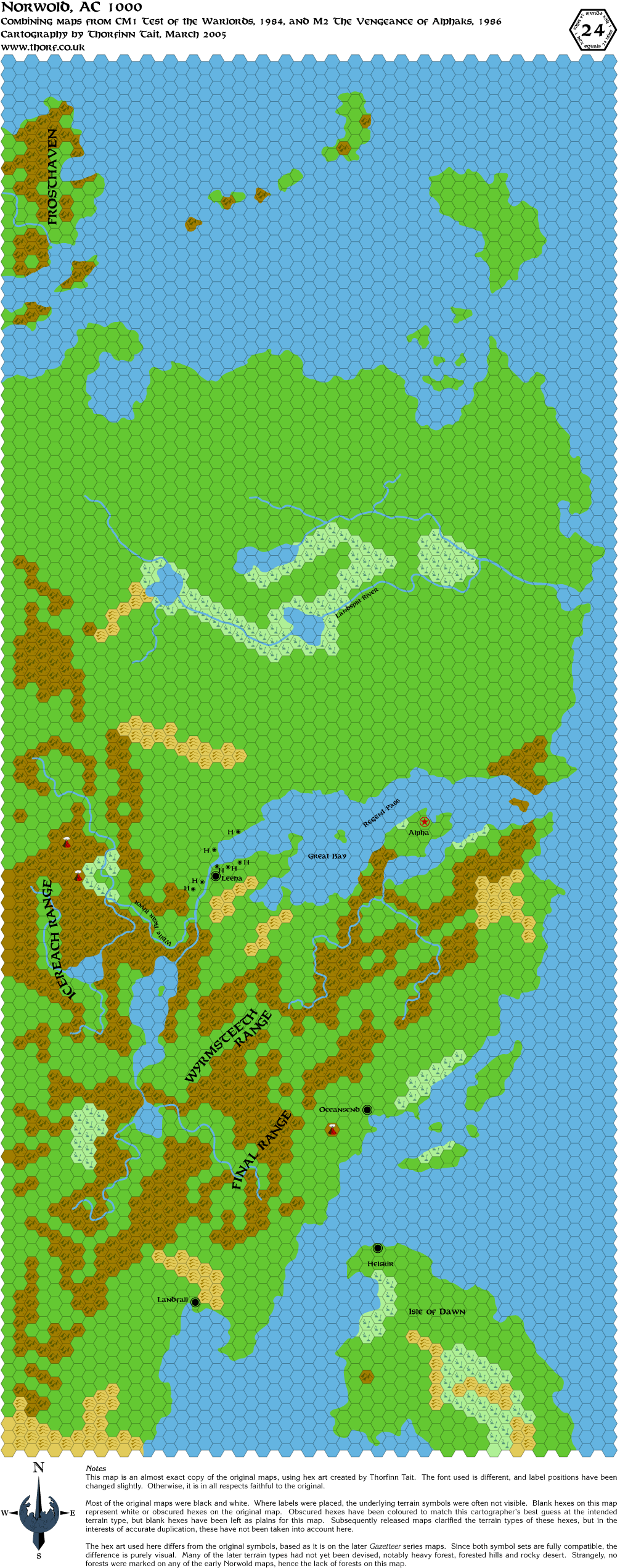
cm1-m2-norwold
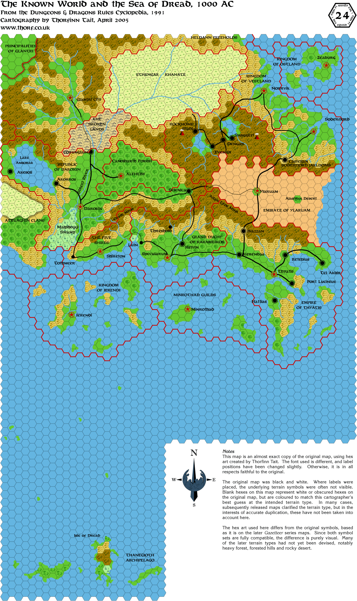
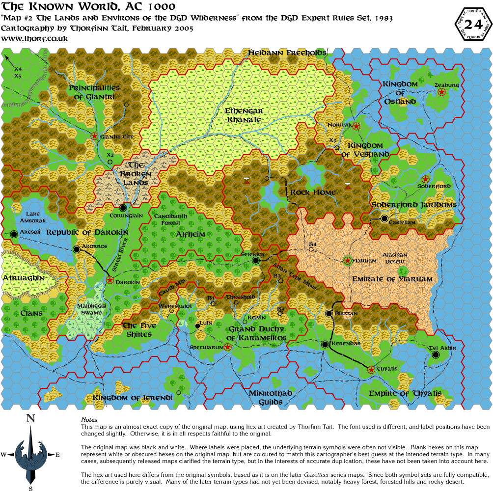
cyclopedia-known-world
dawn-alatians*
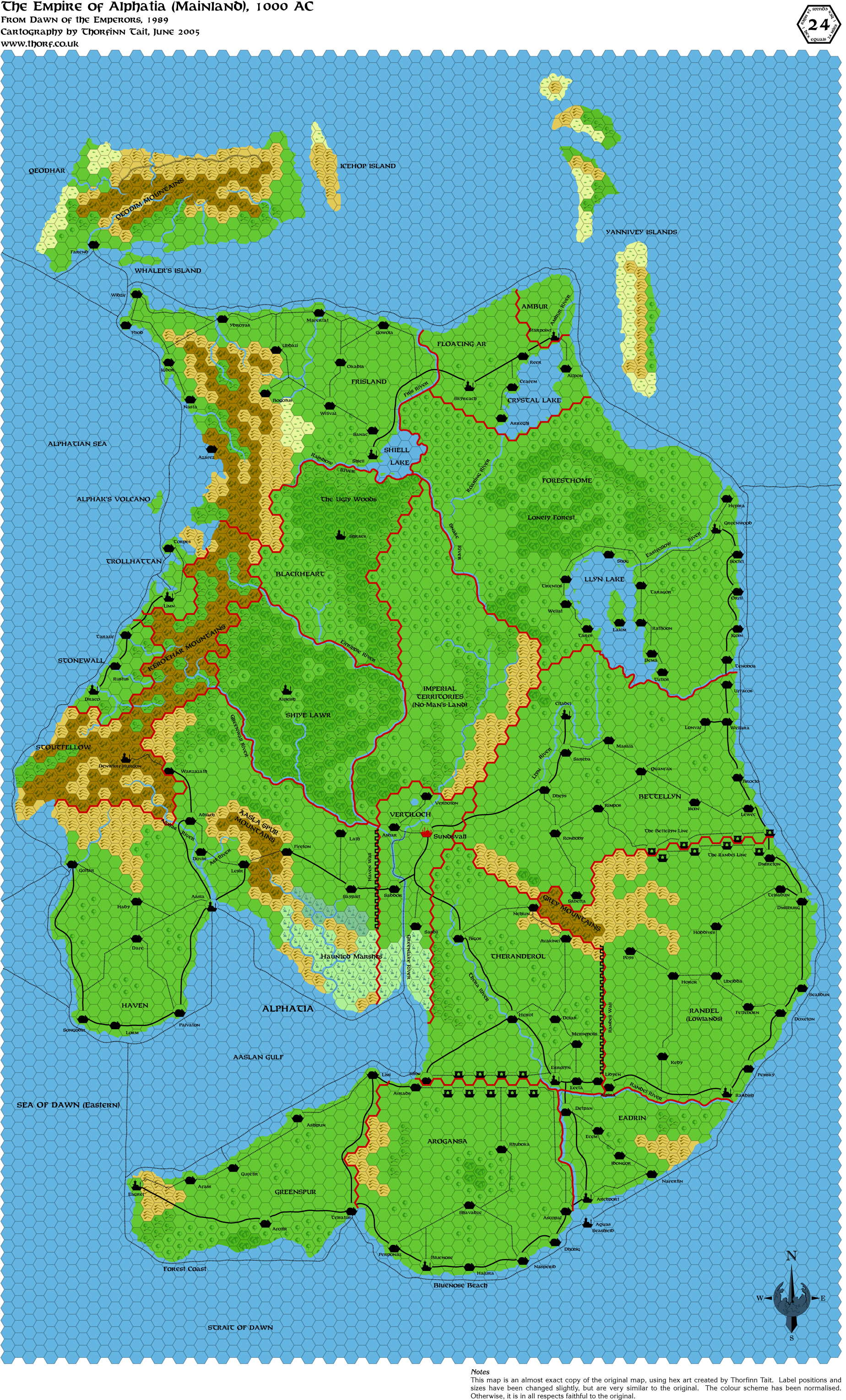
dawn-alphatia*
dawn-isle-of-dawn*
dawn-ochalea-pearl*
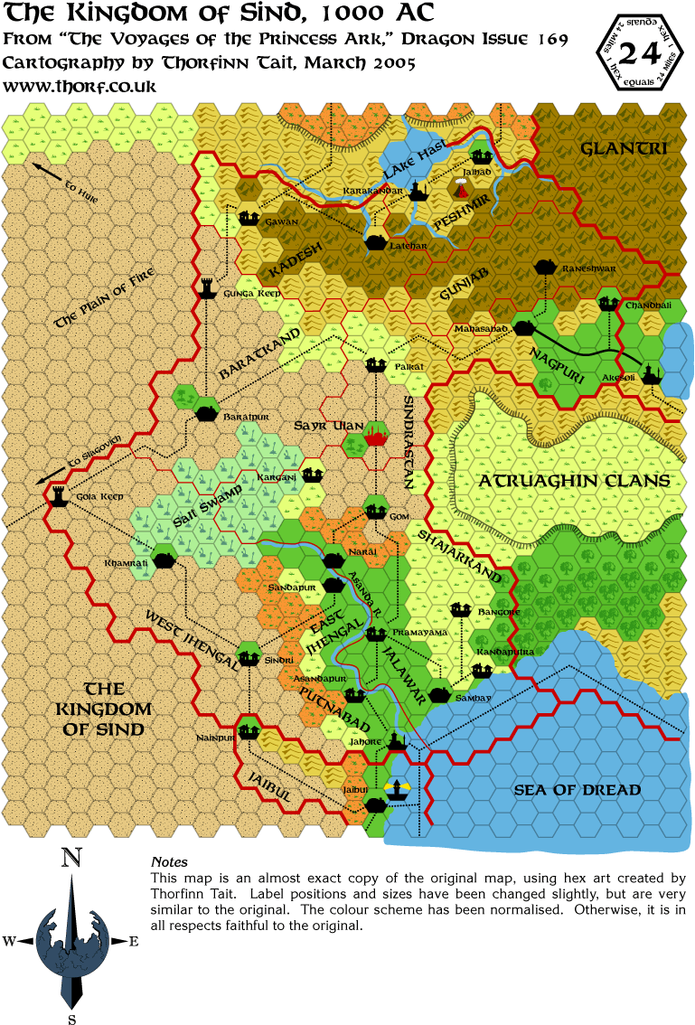
dragon169-sind
dragon196-orc's-head
dragon200-arm-immortals
great-waste
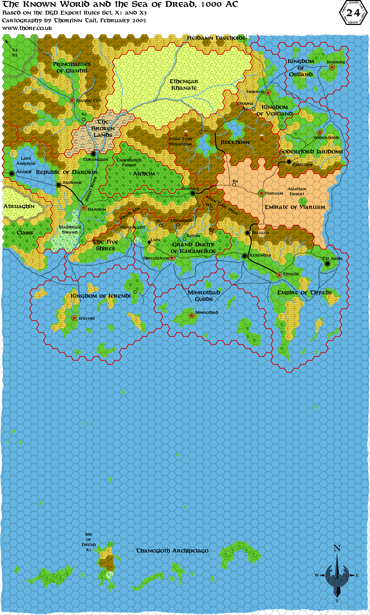
expert-set-known-world
known-world
serpent-peninsula*
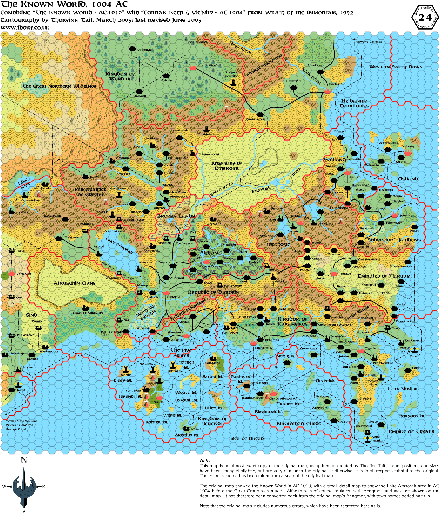
wrath-known-world-1004ac-p*
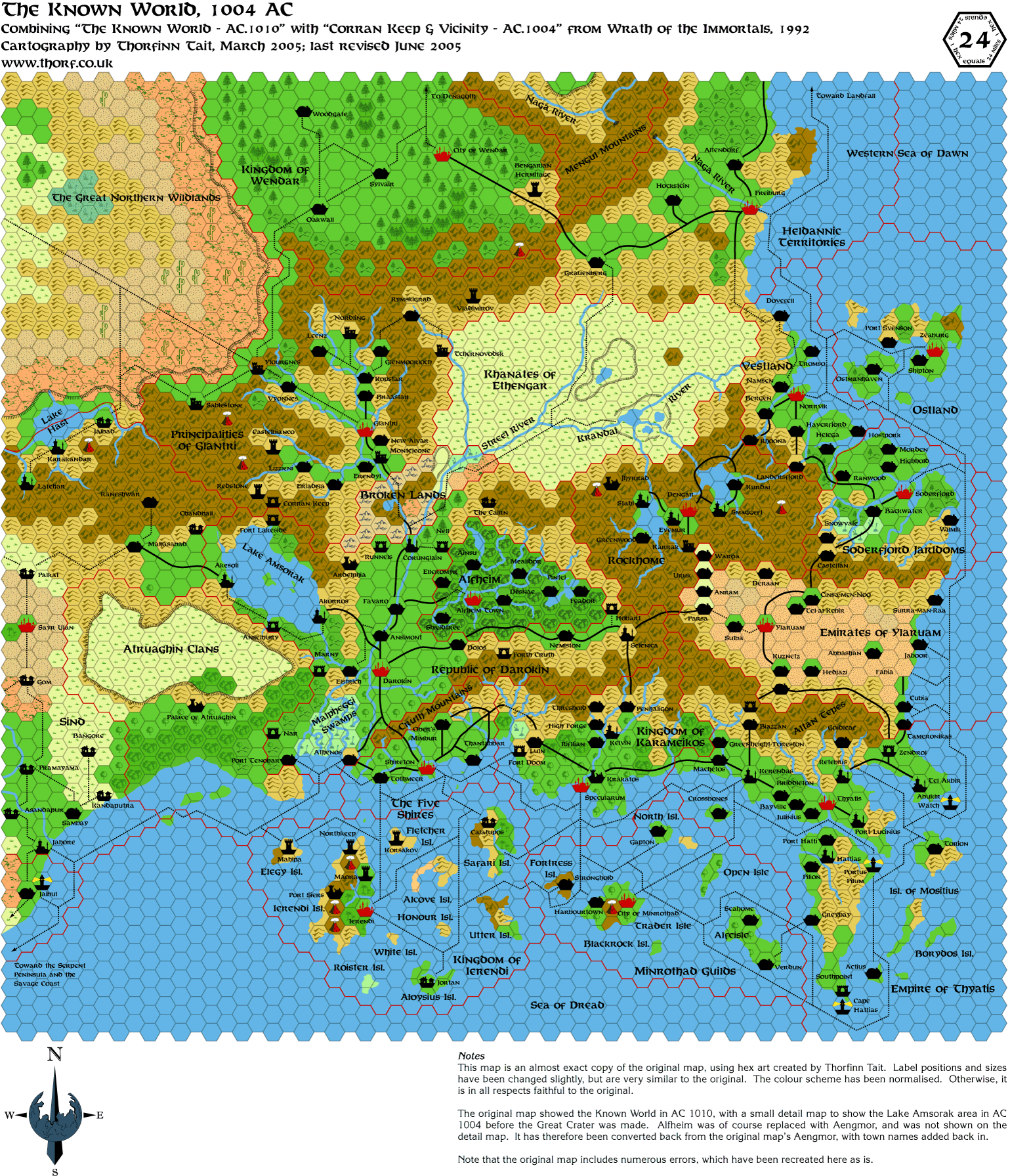
wrath-known-world-1004ac
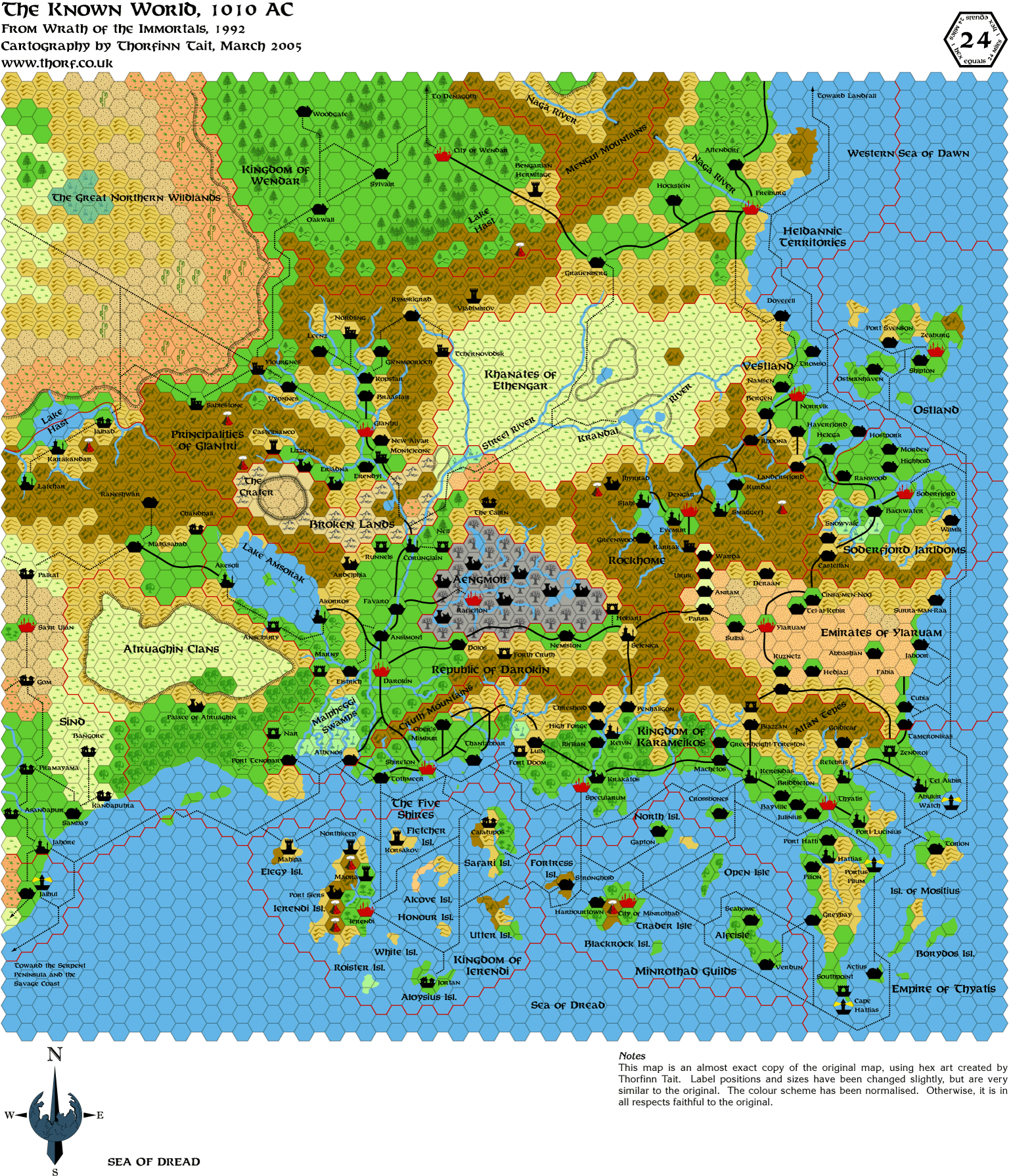
wrath-known-world-1010ac
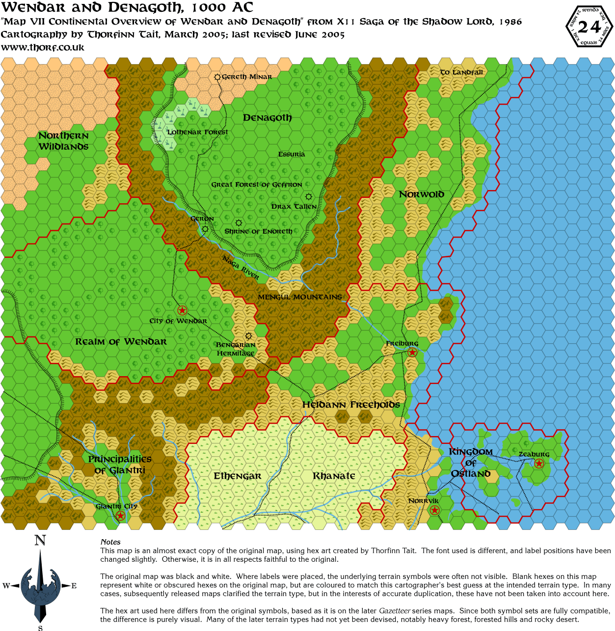
x11-wendar-and-denagoth
x4-great-waste
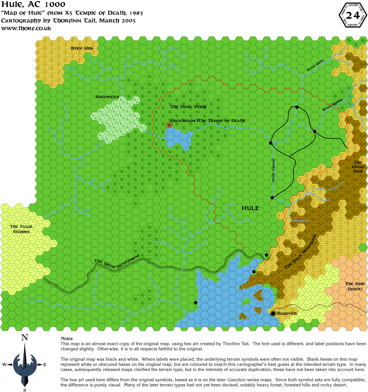
x5-hule
Scale 40 ( 5)
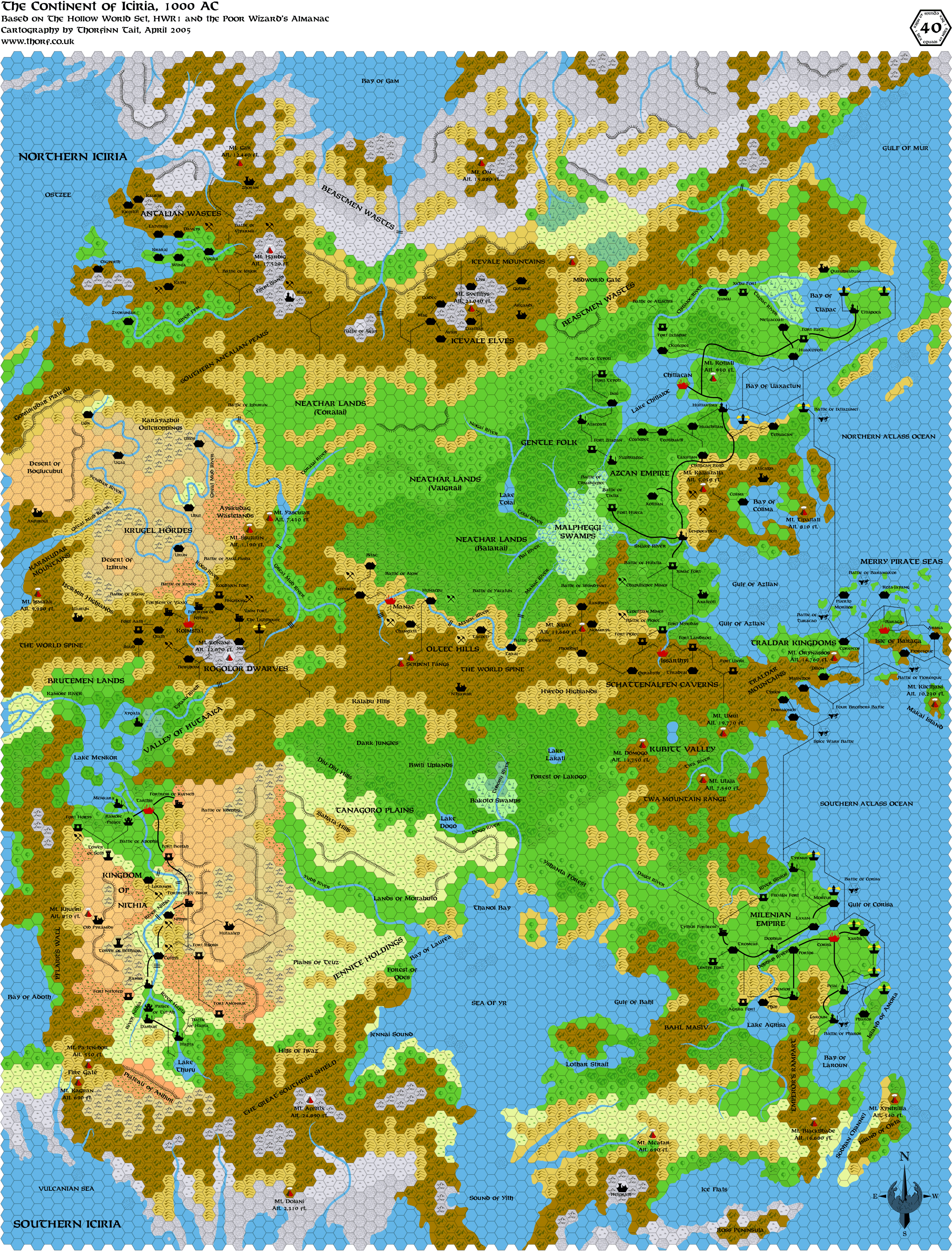
iciria*
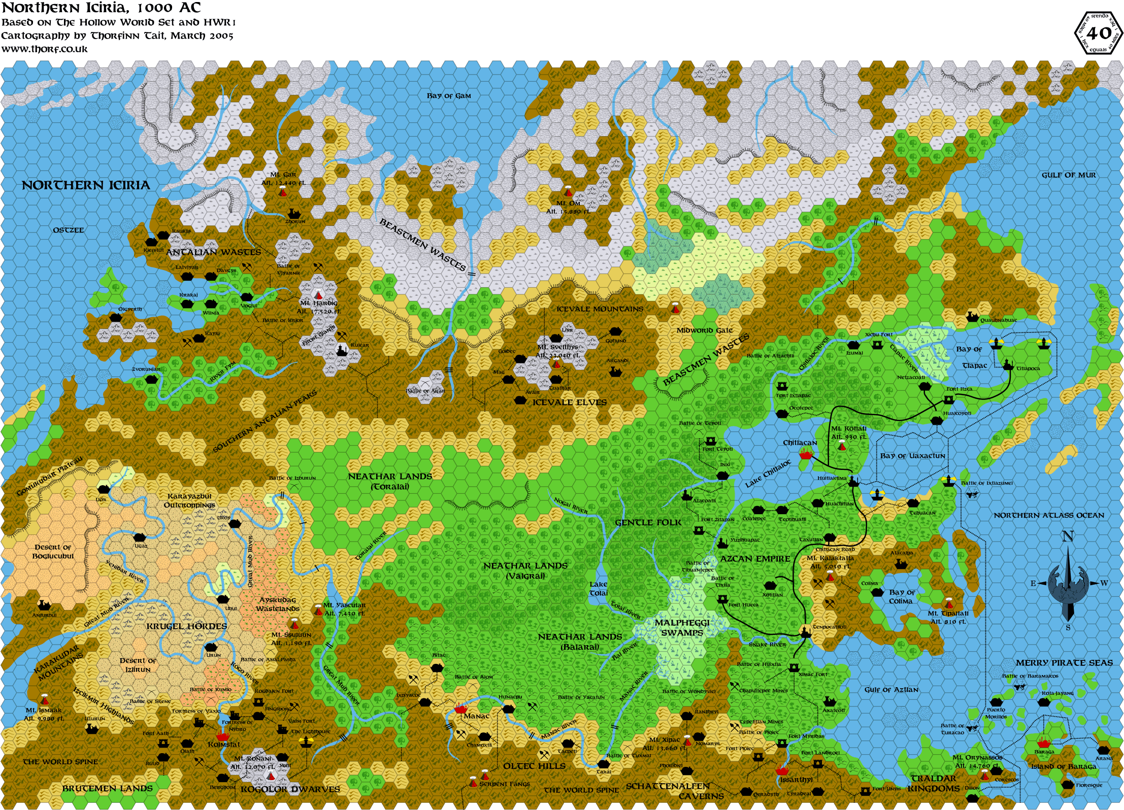
northern-iciria
northern-iciria-1004ac*
southern-iciria
wrath-alphatian-neatharum*
Others ( 2)
heldan_border+
master-outer-world*
|
16 June 2005, 17:09:13
|
 |
|
|
Join Date: Mar 2004
Location: Ontario, Canada
|
|
Quote:
|
There are three things to note about this situation. First, TM2 does indeed show villages and settlements with Antalian-style names, and they are indeed placed geographically within the borders of the Grand Duchy of Westrourke.
Next, GAZ7 describes seven Ostland colonies (three established, four in planning stages) on the Isle of Dawn. It seems to make sense for the settlements on TM2 to be those colonies. Aside from these colonies and a few fortifications, Westrourke seems to be largely unsettled. This could explain the real reason for the colonies to be allowed - not to cause problems for Alphatia, as hinted in GAZ7, but just to settle a previously unsettled region of the Isle of Dawn. Quite probably the colonies have to pay taxes to both Zeaburg and Newkirk.
Last, Dawn of the Emperors describes a line of signal towers maintained by the Archduke of Westrourke, stretching from Newkirk to Finnegar's Watch. These are of course marked on the map, and interestingly the Ostland colonies are in and around the area of Finnegar's Watch. This suggests a fair level of contact between the Ostland colonies and Newkirk; the colonies can't just be quietly getting away with existing on Thyatian territory, because the Thyatian soldiers and citizens stationed in the watch towers must have contact with the villages, and possibly even rely on them for some supplies.
|
I did not know all this before! VERY interesting. This stuff could make a Northern Reaches campaign even better - raiding between mainland settlements and Isle of Dawn settlements and all that complexe political manuevering during the whole thing. Great area for a PC to try to forge himself a dominion. *Wheels are turning*
Hey, Shughuy! Excellent work on the index!
|
16 June 2005, 18:41:42
|
|
|
Quote:
|
Hey, Shughuy! Excellent work on the index!
|
Thanks
Moreover, i changed the presentation on the website, it's now a little bit more Thorf's spirit, at least the design. I'll have to change some things, but now, time to go to bed, dreaming about cool maps i'll find tomorrow morning.
|
16 June 2005, 18:52:23
|
 |
|
|
Join Date: Apr 2004
Location: Long Beach, CA
|
|
Quote:
|
Next, GAZ7 describes seven Ostland colonies (three established, four in planning stages) on the Isle of Dawn. It seems to make sense for the settlements on TM2 to be those colonies. Aside from these colonies and a few fortifications, Westrourke seems to be largely unsettled. This could explain the real reason for the colonies to be allowed - not to cause problems for Alphatia, as hinted in GAZ7, but just to settle a previously unsettled region of the Isle of Dawn. Quite probably the colonies have to pay taxes to both Zeaburg and Newkirk.
Last, Dawn of the Emperors describes a line of signal towers maintained by the Archduke of Westrourke, stretching from Newkirk to Finnegar's Watch. These are of course marked on the map, and interestingly the Ostland colonies are in and around the area of Finnegar's Watch. This suggests a fair level of contact between the Ostland colonies and Newkirk; the colonies can't just be quietly getting away with existing on Thyatian territory, because the Thyatian soldiers and citizens stationed in the watch towers must have contact with the villages, and possibly even rely on them for some supplies.
|
Just to add to your points- there are a few more settlements with Ostland sounding names than the 3 established ones mentioned in Gaz7- whether these are the others- obviously in more than just planning stages- or not, is unclear, or even if any of them are. I've always assumed them to be Ostland colonies, though.
Also, most maps of the Isle of Dawn have borders that are very different from one another. IIRC, at least one of those maps depicts very different borders for Westrourke than we see above. In any case, as Thorf notes, Westrourke is largely unsettled. There was at least one Dragon article (an errata to the PWA1010 map, IIRC) where Bruce Heard mentioned something to that effect as well. I'll try and find out details and post them here.
Further to all of the above, it is noted in the Ostland Gaz that Ostland has recently signed treaties with the Empire of Thyatis, and the colonies on the IoD are part of that agreement (again, IIRC). I could see the Thyatians, possibly unable to find settlers among their own people (they have so many colonial lands already, and a limited population base to settle there), encouraging the settlement of those lands by the Ostlanders. There are doubtless some sovereignty issues, but as the Ostlanders are allies, and close relatives of the Antalian people Thincol is descended from, they could very well have worked something out.
[EDIT] For more on Ostland, check out Jacob Skytte's wonderful Domains of Ostland articles on the Vaults. In particular, he mentions the Isle of Dawn in the Domain of Aland entry.
|
17 June 2005, 3:38:44
|
|
|
|
Join Date: Jan 2005
Location: Akita, Japan
|
|
Quote:
Please, focus on the maps. I would be glad to help you to reorganize your website. These maps are so awesome, don't waste your time with just writing uninteresting lines of code... |
Thanks a lot! This is great, you're saving me a lot of time.
Quote:
|
Would you mind telling me if your website is supporting php. Maybe it could be easier to deal with the thumbnails and everything.
|
I'm not sure, I'm afraid. I was doing the thumbnails in Photoshop, but it takes a fair bit of time to make them all that way. The end result is nice, but you seem to have been able to do almost the same thing much faster. I quite like your presentation style too, making it seem more like an FTP site or archive than a web page - which is exactly what I want.
Quote:
This link goes to My Website. It's not really nice right now, but i'll work on it. There are 3 directories 08/24/40 for each categories of maps. Enjoy. |
This is really cool too. The only addition it really needs is descriptions for each of the maps, and a little reorganising (see below). The idea of splitting it into directories for scale is great, especially since that is how my files are stored here, which makes things very easy for me. Of course eventually we'll need to add extra folders - 72 mi per hex, non-hex (that's where the Master Set map goes), etc.
Any ideas for how we can handle updates and stuff? At the moment updating the site is so time consuming that I only do it every few months...
Quote:
|
And the list of every maps which where posted (i think) :
The ones with * are not hosted by Thorf, which explain why the links were previously dead.
The one with + was posted by Mah9.
|
Haha, you actually posted links to maps which I haven't revealed yet!!   To be honest I've been wondering how long it would take for someone to realise that I sometimes upload maps ahead of schedule. Anyway, I fixed the "problem".
There are actually have two servers on which I post Mystara maps, so most of them are indeed hosted by me. The first server is full, which is why I am borrowing space on one of my father's web servers for the more recent maps. And the other map is a partial map Mark uploaded to help me, so it doesn't need to be on the list.
Lastly, I want to reorganise the list to split it into Updated Maps and Replicas, because listing them together is extremely confusing, I think. And people seem to be confused enough by this as it is.
I'm going to redo the list now in the first post of the thread, moving around the links you created. Thanks again!
|
17 June 2005, 3:41:11
|
|
|
|
Join Date: Jan 2005
Location: Akita, Japan
|
|
This map has a few extra trade routes, and labels have been reformatted to match the rest of my maps.
Most significantly though it has evergreen forest hexes. I'd love to hear feedback on how far south they go!
I also updated yesterday's map with the corrections Jesper provided. Thanks! |
17 June 2005, 4:18:14
|
|
|
Quote:
Thanks a lot! This is great, you're saving me a lot of time.
...
The end result is nice, but you seem to have been able to do almost the same thing much faster. I quite like your presentation style too, making it seem more like an FTP site or archive than a web page - which is exactly what I want.
...
This is really cool too. The only addition it really needs is descriptions for each of the maps, and a little reorganising (see below). The idea of splitting it into directories for scale is great, especially since that is how my files are stored here, which makes things very easy for me. Of course eventually we'll need to add extra folders - 72 mi per hex, non-hex (that's where the Master Set map goes), etc. |
Glad you liked it. In fact, i have every maps on my website where i have PhP and i was able to do the thumbnails very quickly... Hum, PhP did
It was a first try, now i'm going to reorganize stuff, separating revised maps from the original closer than your presentation on your website. That's the problem with automatization. About the FTP aspect, i wanted to do more, but i wasn't allowed to post a lot of images...
Quote:
Any ideas for how we can handle updates and stuff? At the moment updating the site is so time consuming that I only do it every few months...
...
Haha, you actually posted links to maps which I haven't revealed yet!! To be honest I've been wondering how long it would take for someone to realise that I sometimes upload maps ahead of schedule. Anyway, I fixed the "problem". |
 i'm sorry about unveilling maps... I thought i missed them in the topic... By the way, put an index.html file in the directory where they are if you didn't already. I'm opened to every notices to improve the presentation.
As i said don't worry about updating very often your site, mine will be, and i can still giving you the source file.
I won't have do anything without your maps I just put a little order in your wild creations... Please, Keep going on.
PS : Hope i'm not doing to many mistakes.
|
17 June 2005, 4:50:19
|
|
|
|
Join Date: Jan 2005
Location: Akita, Japan
|
|
I just updated the first post of this thread with the new and improved index. Special thanks to Shughuy for making it all much, much easier for me!
Quote:
Glad you liked it. In fact, i have every maps on my website where i have PhP and i was able to do the thumbnails very quickly... Hum, PhP did
It was a first try, now i'm going to reorganize stuff, separating revised maps from the original closer than your presentation on your website. That's the problem with automatization. About the FTP aspect, i wanted to do more, but i wasn't allowed to post a lot of images... |
Okay, that's great. Regarding how to organise the maps, it would be best if you could do it the same way I have done it in the index. Basically, it's split into two folders, updated maps and replicas, and each of those is subdivided into folders based on the scale.
Quote:
i'm sorry about unveilling maps... I thought i missed them in the topic... By the way, put an index.html file in the directory where they are if you didn't already. I'm opened to every notices to improve the presentation.
As i said don't worry about updating very often your site, mine will be, and i can still giving you the source file. |
Hehe, don't worry about it. I'll be posting it "officially" here on Monday anyway, though you can all check it out before then - if you can figure out what map it is.
Okay, in that case once you've settled on the final form for your page, please let me know (and perhaps send it and the thumbnails to me in e-mail?), and if you don't mind I'll stick it on my page. My page doesn't actually need to be 100% up to date, because it points back to this thread anyway. But the address given on every map points there, so I obviously need to have something there.
Quote:
I won't have do anything without your maps I just put a little order in your wild creations... Please, Keep going on. |
Thanks again! You really are a lifesaver. |
17 June 2005, 5:39:38
|
|
|
|
Join Date: Apr 2004
Location: Denmark
|
|
Quote:
|
This map has a few extra trade routes, and labels have been reformatted to match the rest of my maps.
Most significantly though it has evergreen forest hexes. I'd love to hear feedback on how far south they go!
|
I like the map and I think the line between evergreen and normal forest is quite fitting.
I just spotted something though:
Is it a mistake that you have named the road between Donahue's Cove and Dunganna "Portage Road" ??
It would make sense to me that "Portage Road" would link West and East Portage... 
Quote:
|
I also updated yesterday's map with the corrections Jesper provided. Thanks!
|
You're welcome!
:-) Jesper
|
17 June 2005, 5:51:39
|
 |
|
|
Join Date: Jun 2003
Location: Liverpool, England
|
|
Quote:
Is it a mistake that you have named the road between Donahue's Cove and Dunganna "Portage Road" ??
It would make sense to me that "Portage Road" would link West and East Portage... |
Unless, of course, it's the road to West Portage from Dungannon via a Donahue's Cove ferry?
Regards,
Gary
|
17 June 2005, 9:20:21
|
|
|
Quote:
|
Okay, in that case once you've settled on the final form for your page, please let me know (and perhaps send it and the thumbnails to me in e-mail?), and if you don't mind I'll stick it on my page. My page doesn't actually need to be 100% up to date, because it points back to this thread anyway. But the address given on every map points there, so I obviously need to have something there.
|
I think it looks better now. I did it according to your modified index in the first post. Every map is in its appropriate directory. Now, i just have to be carefull about the updates you are doing. And if i'm not wrong, i already have two updates to do The one from today and the other one from yesterday.
About sending everything by email, i agree but... maybe in several times. The thumbnails are weighting more than 1 Mo Or maybe can i put a zip with some thumbnails in it and you could download them... ?
Edit : Sure, you can stick it.
|
18 June 2005, 15:38:49
|
|
|
|
Join Date: Jan 2005
Location: Akita, Japan
|
|
This thread just passed 10,000 on the thread view counter!     
I'd like to take this opportunity to say thanks to all of you for your interest and support of my project. 
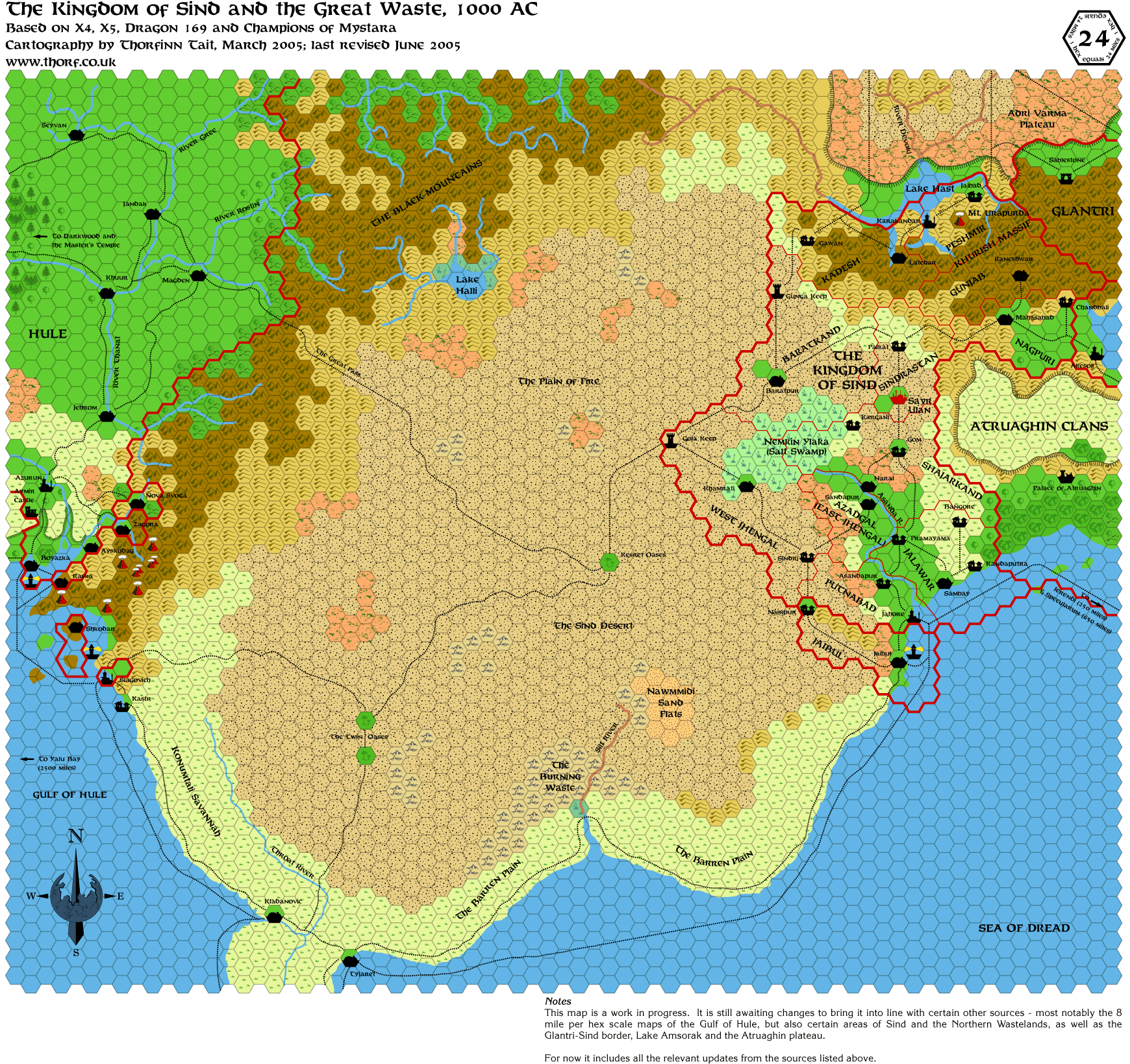
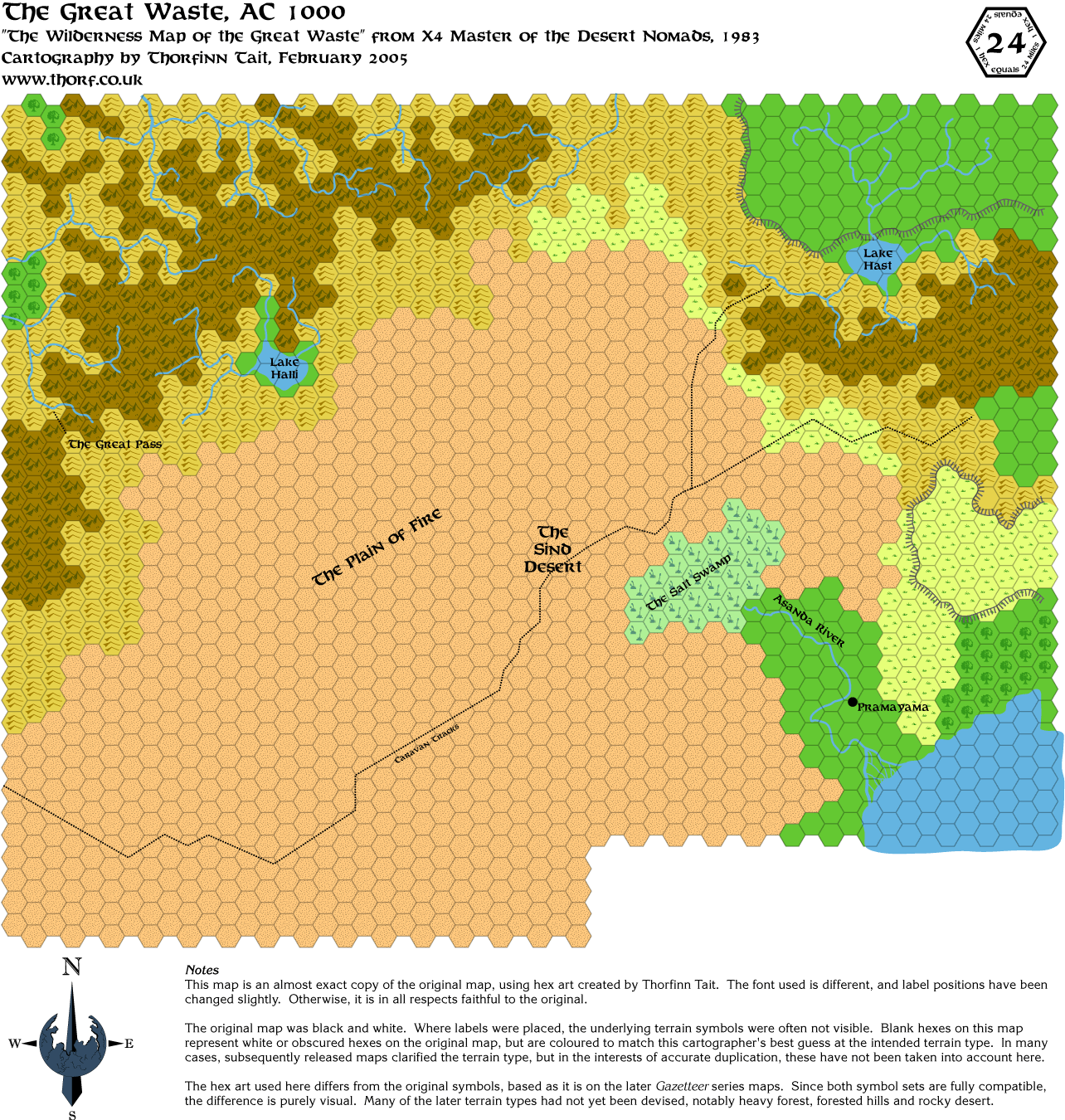
Yesterday I updated the Great Waste map from Champions of Mystara, and today I updated the Legend (yes, finally ). The Legend was way out of date, but I'm not entirely sure that I caught everything in this new one. I will be adding some more to this Legend eventually, but I'm considering splitting the it into two, one with universal symbols, the other with country or region-specific symbols. And there will be two more Legends coming soon, covering the underground and underwater hexes.
(Edit: You can find these revisions in the index on page one of this thread from now on. I am marking the updates there as I do them, just look for the mark.)
That's the big news for today - I completed work on all of the underwater hexes tonight. For now the palette is just a direct copy of my scan of PC3's maps, although it may change in the course of making the map.
I will post the underwater Legend sometime next week, I think, and with any luck I will get the Undersea map done soon too. I'm highly motivated to work on it, because it provides the most detailed and accurate coastlines and water depths for the Sea of Dread area. I will also be remaking the X7 underwater map, although it remains to be seen how compatible it is with PC3's map.
Symbol-wise, I think all I have left to do is the HWR3 Milenian Empire symbols, which look like being the hardest. But I'm in no hurry to do them, because there's a lot of work to be done on other areas first.
To sum things up - there are some great things in store for you in the next week or two, so stay tuned! |
19 June 2005, 4:46:47
|
|
|
|
Join Date: Jan 2005
Location: Akita, Japan
|
|
Check out the first post of this thread for a whole host of updates, mainly bringing the updated Gazetteer maps up to date with my newest hex art revisions, but also including some corrections and such.
Note that a number of the maps have had their filename changed from what it was before, so that they fit into my naming system better. Basically, the updated maps have just their country/region name plus the scale. Variations of those maps have the variation listed after the scale. Lastly, replica maps have their source listed first in the filename.
So, for example, atruaghin-8.png is my updated Atruaghin Clans map, while gaz14-atruaghin-8.png is my replica of the original map (including all errors, etc.). Another example is that karamiekos-8.png is my updated Karameikos map, while karameikos-8-forested-hills.png is a variation of that map showing most of the hills as forested hills.
If this explanation confuses you, feel free to ignore it, but I'm sure some of you will find it useful. |
20 June 2005, 2:04:22
|
|
|
|
Join Date: Jan 2005
Location: Akita, Japan
|
|
Quote:
I think it looks better now. I did it according to your modified index in the first post. Every map is in its appropriate directory. Now, i just have to be carefull about the updates you are doing. And if i'm not wrong, i already have two updates to do The one from today and the other one from yesterday. |
I just checked out your page again - wow, it's looking great!
You will need to be careful with the updates, I'm afraid, because sometimes the filenames change. I am making sure to mark which ones change in the index, though.
Quote:
About sending everything by email, i agree but... maybe in several times. The thumbnails are weighting more than 1 Mo Or maybe can i put a zip with some thumbnails in it and you could download them... ? |
Zipping them so I can download them would be fine too. After we've updated my page the first time, I can just download them manually from your page one by one.
By the way, you don't need to list Mark's Heldann border map. Nor the karameikos-shaded-forests.png map, which was just an experiment and is now out of date. Otherwise, your page is looking great!
|
20 June 2005, 2:08:13
|
|
|
|
Join Date: Jan 2005
Location: Akita, Japan
|
|
This one was actually in the index since last week, but for those of you who didn't find it...
 |
20 June 2005, 6:16:05
|
|
|
I'll try to do the updates tonight around 9:00 PM (French time).
Putting the new modified maps and the zip for the thumbnails.
Hope i won't make mistakes about the new spelling of some maps. Do not hesitate if you see an error to warn me.
Good job again Thorf, nice map, even if i had already see it |
20 June 2005, 8:14:15
|
|
|
Join Date: Feb 2005
Location: Ontario, Canada
|
|
Quote:
|
This one was actually in the index since last week, but for those of you who didn't find it...
|
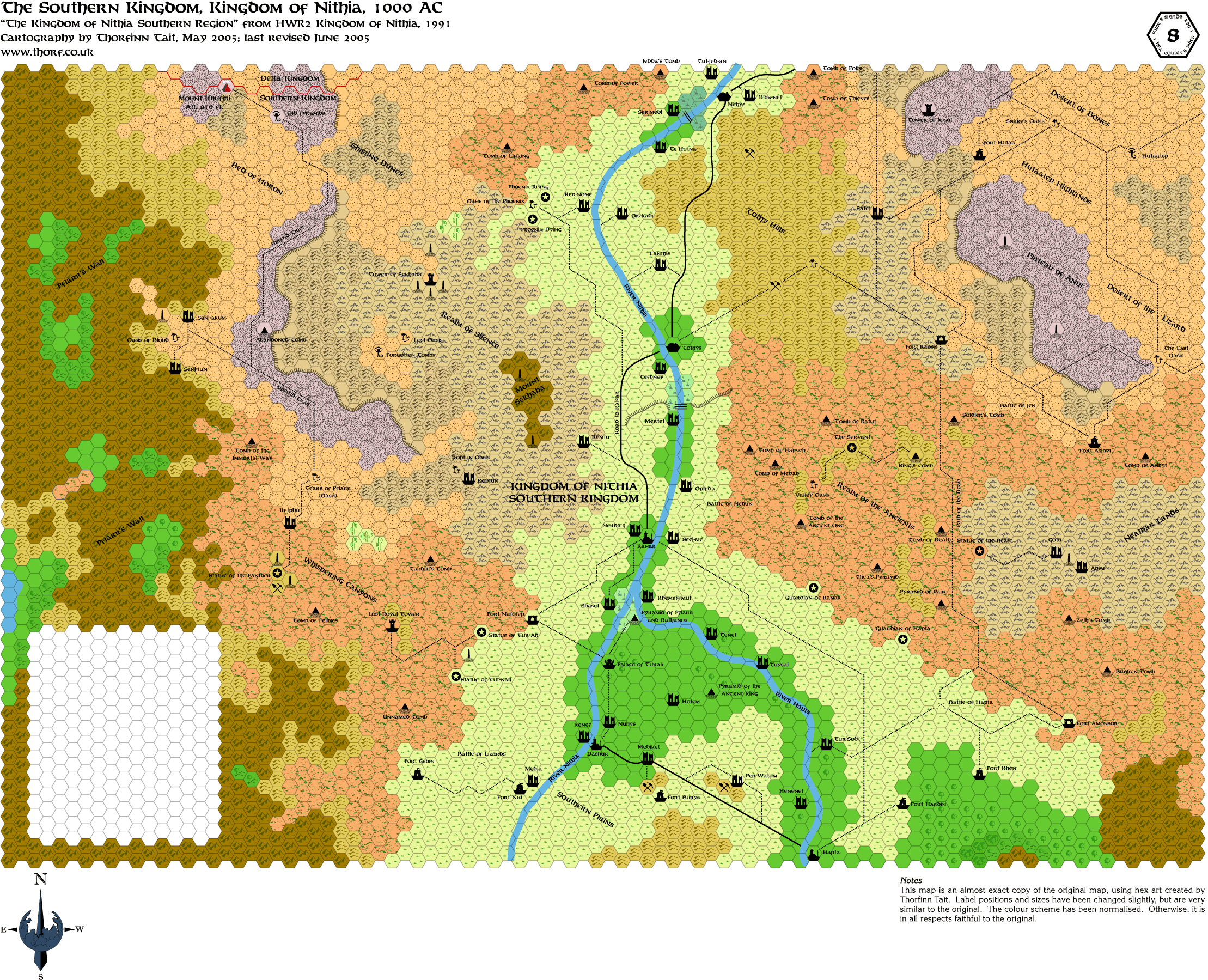
Great stuff Thorf! The only minor thing I noticed was that some of the oases are the same colour as the desert (e.g., Oasis of Blood, near Pflarr's Wall).
Geoff
|
20 June 2005, 12:13:05
|
|
|
|
Join Date: Jan 2005
Location: Akita, Japan
|
|
Quote:
|
Great stuff Thorf! The only minor thing I noticed was that some of the oases are the same colour as the desert (e.g., Oasis of Blood, near Pflarr's Wall).
|
I'm glad you brought these up. HWR2 shows them like this, and I have been considering adopting them for all oases. Presumably most oases are pretty small affairs, so it seems to me to make a lot more sense to show the general terrain type rather than a simple grassland (or jungle) terrain as the background to the oasis symbol.
The end result is that we get more information about the terrain of the tile by using HWR2 oasis hexes. Normal oasis hexes only tell you that there is an oasis in that hex, and nothing about the surrounding terrain, whereas HWR2's oasis hexes tell us both.
|
20 June 2005, 12:58:03
|
|
|
Join Date: Feb 2005
Location: Ontario, Canada
|
|
Quote:
|
I'm glad you brought these up. HWR2 shows them like this, and I have been considering adopting them for all oases. Presumably most oases are pretty small affairs, so it seems to me to make a lot more sense to show the general terrain type rather than a simple grassland (or jungle) terrain as the background to the oasis symbol.
|
Oh, okay. That clears things up then. Looking at the map again, do you plan to fill in the blank patch that was, presumably, where the original map had its legend (I don't have my paper copy handy)?
Geoff
|
20 June 2005, 14:40:14
|
|
|
|
Join Date: Jan 2005
Location: Akita, Japan
|
|
I do indeed.
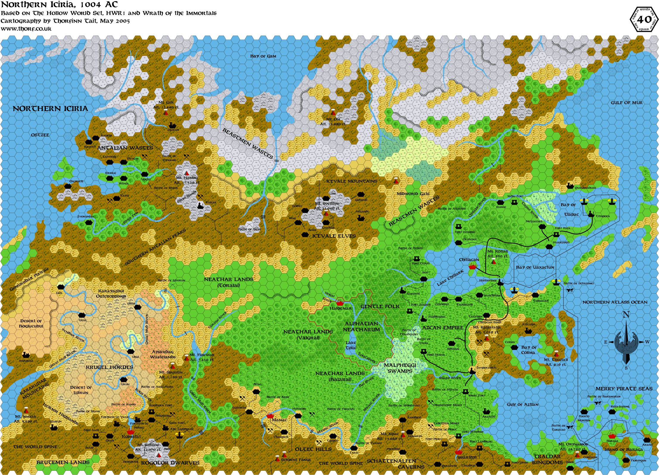
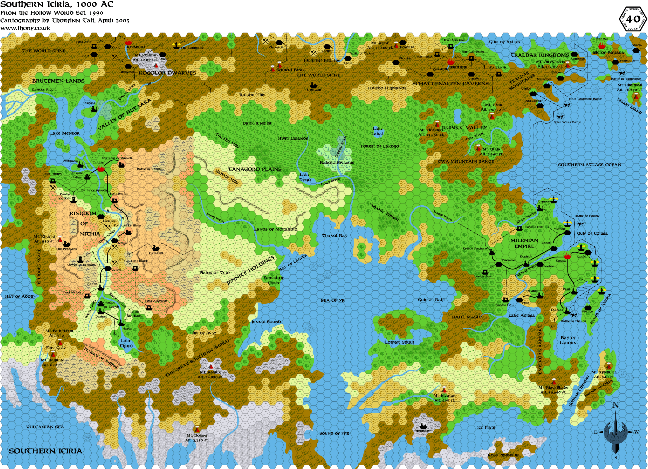
In fact, when I put this map together with the 40 mi per hex Iciria map in order to see what terrain should be there, I made the very happy discovery that the maps line up perfectly, and are highly consistent.  So it looks like it's going to be quite easy to expand the Hollow World maps - although I haven't tried the Azca and Milenia maps yet...
It's so nice to have different scales that line up properly!
I wish the outer world was this simple...  |
20 June 2005, 19:33:56
|
|
|
|
Join Date: Jan 2005
Location: Akita, Japan
|
|
|
20 June 2005, 19:44:56
|
|
|
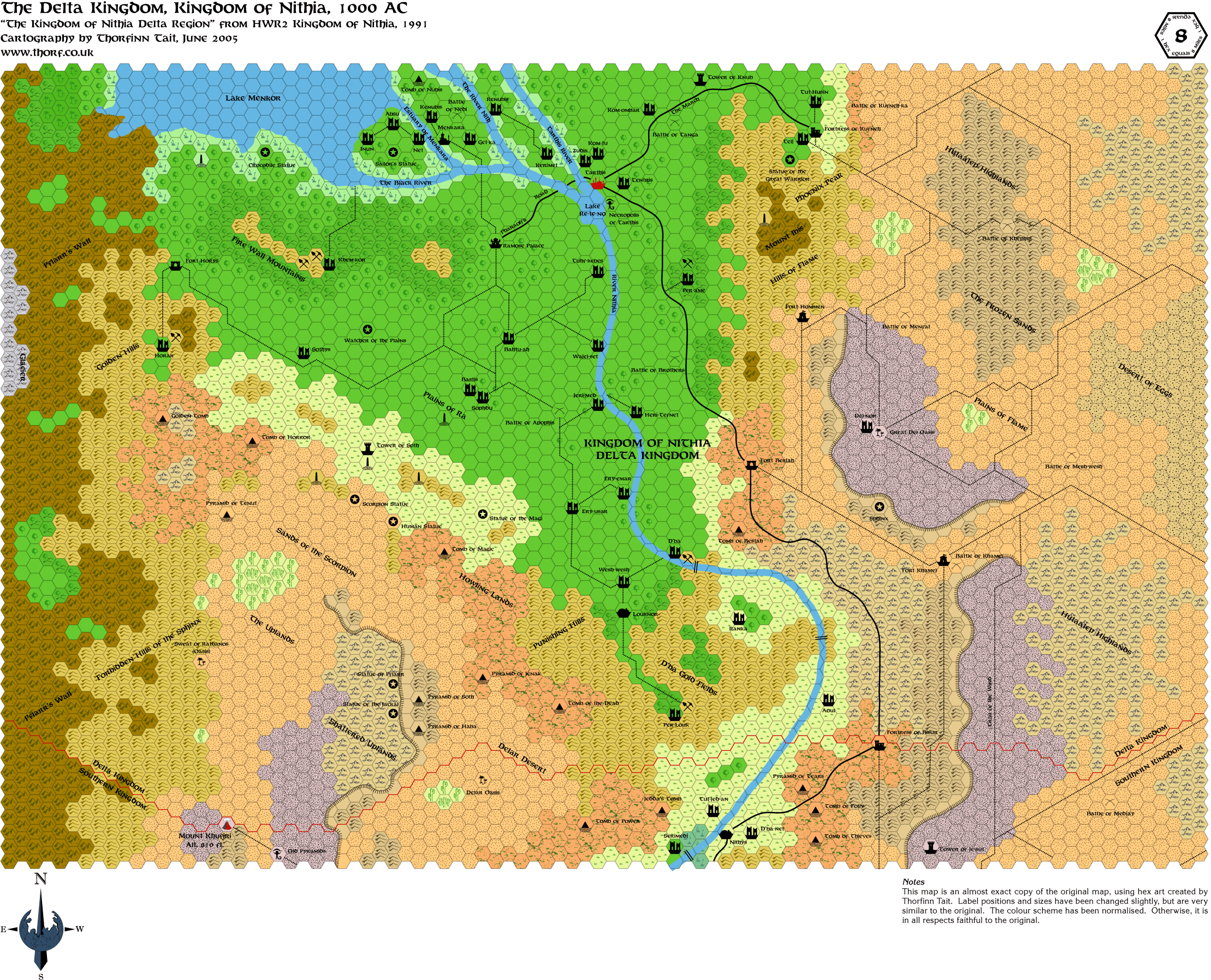
Another great map
Just wondering do any of the moniliths have titles or names, or are they just random standing stones? |
20 June 2005, 19:48:56
|
|
|
|
Join Date: Jan 2005
Location: Akita, Japan
|
|
No names as far as I know, I'm afraid. HWR2 gives rules for them, but it would have been nice to have something to make them a little more unique from each other. As it is now, we just have random monoliths scattered around the maps.
On another note, I'm sure you can all guess what tomorrow's map will probably be. If I can get it finished in time, that is... Full day of work today.  |
|
|