Thorf's Secret Project: Stage One
A recreation of the Mystara Message Board thread that started the Atlas of Mystara project, with restored links and images.

2 April 2005, 12:54 PM
|
|
Member
|
|
Join Date: Mar 2001
Location: Twin Cities, MN
|
|
Quote:
|
Originally Posted by Culture20
Western Herath is actually depicted with 24mph in Dragon #196, along with the Orcs Head Penninsula.
|
Ah!
That's what I thought you might have meant. Whew!
|

3 April 2005, 10:23 PM
|
 |
Member
|
|
Join Date: Apr 2004
Location: Denmark
|
|
 dragon sight
Quote:
|
Originally Posted by katana_one
Next we'll be discussing how improbable it is for dragons to fly …
|
A friend of mine actually pointed out yesterday that most traditional
fantasy illustrations have dragons painted in a way that spaces their
eyes so far apart on either side of their head that they wouldn't have
any 3D vision or sense of depth.
Makes for pretty catastrophic landings by dragons weighing several tons, huh? 
;-) Jesper
|

3 April 2005, 11:07 PM
|
 |
Member
|
|
Join Date: Jan 2005
Location: Akita, Japan
|
|
 Update
I
can't guarantee anything for the next few days (weeks?), I'm afraid.
Something awful happened this weekend, and it's going to take some time
to get over.  (There just isn't any smiley that matches this feeling.)
Don't worry, that's not to say I won't post any maps, but it might well not be possible to post one each day for a while.
|

3 April 2005, 11:32 PM
|
 |
Member
|
|
Join Date: Mar 2004
Location: Stockholm, Sweden. For a while.
|
|
Feel Well, Thorf. 
And take your time.
|

4 April 2005, 09:15 AM
|
 |
Member
|
|
|
|
 Shadow Elves' caverns
Quote:
As you can see, it's an upgraded version of my previous map. It took a while to add in the walls, but I think it
was well worth doing. The walls themselves are basically just random squiggles. Mostly I kept them quite
simple, but you can see an example of more complex squiggles in the bottom right, where I went all out for the
last few lines.
|
Thorf, I hope that you're doing OK.
I found a map in PWA3 that I scanned in and will send you that has the
cavern walls for the SE territorities. You could probably just trace it
to update your version. IMO, it removes even more of the "hexiness".
|

4 April 2005, 10:27 AM
|
 |
Member
|
|
Join Date: Jan 2005
Location: Akita, Japan
|
|
Quote:
|
Originally Posted by DanEustace
Thorf, I hope that you're doing OK.
I found a map in PWA3 that I scanned in and will send you that has the
cavern walls for the SE territorities. You could probably just trace it
to update your version. IMO, it removes even more of the "hexiness".
|
Ah, someone noticed.  
I came across that map while looking through the Poor Wizard's Almanacs
recently for maps. I had forgotten that there was such a map out there.

In any case, thanks for the scan! I will eventually make another
version of the map using that map as a base for the cavern walls. One
interesting thing about that map is that it gives the Shadow Elves'
caverns a much smoother edge than the Broken Lands caverns. If I
remember rightly, the Poor Wizard's Almanac Broken Lands map is more
smoothed off than the hex map too, though.
Thanks for the well wishes.
|

4 April 2005, 10:48 AM
|
 |
Member
|
|
Join Date: Apr 2004
Location: Long Beach, CA
|
|
Quote:
|
Originally Posted by Thorf
In
any case, thanks for the scan! I will eventually make another version
of the map using that map as a base for the cavern walls. One
interesting thing about that map is that it gives the Shadow Elves'
caverns a much smoother edge than the Broken Lands caverns. If I
remember rightly, the Poor Wizard's Almanac Broken Lands map is more
smoothed off than the hex map too, though.
|
You could always chalk the smoother SE caverns off to the tunnelshapers among the SE (which aren't present among the 'noids).
As for the PWA Broken Lands map... got me on that one. 
|

5 April 2005, 12:28 AM
|
 |
Member
|
|
Join Date: Jan 2005
Location: Akita, Japan
|
|
 Home, at least for now, so...
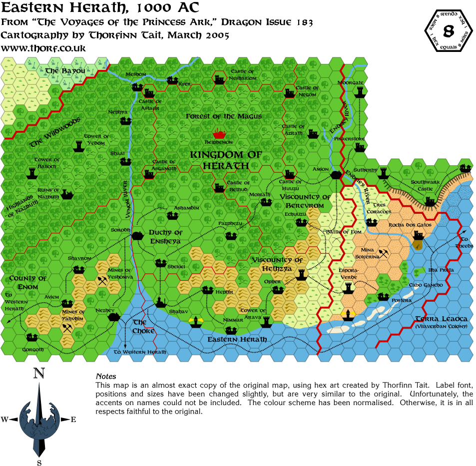
Here's the next map.

|

5 April 2005, 12:35 AM
|
 |
Member
|
|
Join Date: Jan 2005
Location: Akita, Japan
|
|
Quote:
|
Originally Posted by Cthulhudrew
You could always chalk the smoother SE caverns off to the tunnelshapers among the SE (which aren't present among the 'noids).
|
Funny you mention that, because that was the reasoning behind my last
post. I considered making the caverns much smoother on my cavern wall
map too, but eventually decided to go for rougher, more cavern-like
walls.
|

5 April 2005, 04:04 AM
|
 |
Member
|
|
Join Date: Mar 2004
Location: Norway, Europe
|
|
Hey Thorf!
Just wanted to tell you that I am still enjoying your maps! Sorry to
hear about the troubles in your life, but keep those maps coming when
you have time, alright? 
Håvard
|

5 April 2005, 07:52 AM
|
|
Member
|
|
Join Date: Mar 2001
Location: Twin Cities, MN
|
|
Bravo with the latest, Thorf!
I think you'll find, as I did, slight disagreement with hexs in the
portions where the Bayou, Easter Herath, and Wallara overlap with
regard to light forest. And speaking of unreconcilable river systems...
We have a tributary of the Venom River coming out of the Bayou and
across the Orc's Head Peninsula to the Western Sea. Now there is something I can't figure out as hard as I try.
Hey Thorf, should the small islands off the coast of Terra Leãoça get a hex in the legend... whatever they are?
|

5 April 2005, 08:59 AM
|
 |
Member
|
|
Join Date: Mar 2004
Location: Ontario, Canada
|
|
Quote:
|
Originally Posted by Eric Anondson
Hey Thorf, should the small islands off the coast of Terra Leãoça get a hex in the legend... whatever they are?
|
They look like sand bars as they are now. Is that what they are
supposed to be? If that is the case, they would be shifting constantly
making for some very treacherous waters to sail near!
|

5 April 2005, 10:46 AM
|
 |
Member
|
|
Join Date: Jan 2005
Location: Akita, Japan
|
|
According
to the legend on the Dragon maps, they are shoals. Today's map actually
has them marked as such on the map, too. And I believe there are more
of them on the Arm of the Immortals 24 mile per hex map too. I'll
update my Legend when I can; I've been needing to update it for a
while, especially with underground hexes.

|

5 April 2005, 12:23 PM
|
 |
Member
|
|
Join Date: Mar 2004
Location: Ontario, Canada
|
|
Quote:
|
Originally Posted by Thorf
According to the legend on the Dragon maps, they are shoals.
|
Ah! Well... still dangerous for sailing any where near them, right?
Down right treacherous, you'd say, eh? Nigh-on 40 vessels gone down
there in resent memory is what they tell me. 
Sorry Thorf. Just some stupid humour from a tired friend. Hoping all
the best for you. As much as I love seeing these maps, don't let it
mess up your personal life; no matter how much we BEG, and PLEAD, and
GET DOWN ON OUR KNEES AND CRY, don't let it become another chore or
burden for you. If it isn't fun, take a breather.
Sorry again; still tired.
|

5 April 2005, 12:40 PM
|
 |
Member
|
|
Join Date: Jan 2005
Location: Akita, Japan
|
|
Don't worry, what happened had nothing to do with mapping. 
Actually I have the next week or so all done now too. In the long term
for this project, I'll probably have more time than I thought I would.
Regarding what happened, let's just say that in January my fiancee and
I had a nice surprise, but on Sunday someone somewhere hit the reset
switch. Apparently this was not the time, but hopefully it will come
again soon. It's very sad, but I don't want to fill this thread with
it. 
|

5 April 2005, 10:03 PM
|
 |
Member
|
|
Join Date: Jan 2004
Location: Italy
|
|
My deepest sympathies to you and your fiancée Thorf.
Take your time to cuddle each other and recover... and don't you ever dare stop thinking of a brighter tomorrow! 
|

6 April 2005, 12:09 AM
|
|
Member
|
|
Join Date: Feb 2005
Location: Ontario, Canada
|
|
Please accept my sympathies, too, Thorf.
Geoff
|

6 April 2005, 07:19 AM
|
 |
Member
|
|
Join Date: Mar 2005
Location: UK
|
|
My sympathies Thorf, to you and your fiancée. First and foremost, make sure you look after your lady.
|

6 April 2005, 07:27 AM
|
|
Member
|
|
Join Date: Mar 2001
Location: Twin Cities, MN
|
|
Quote:
|
Originally Posted by Thorf
I'll update my Legend when I can; I've been needing to update it for a while, especially with underground hexes.
|
Eagerly awaiting the update legend, I hope you'll be updating your downloadable CS files as well.  But no hurry. Take time with your own priorities.
And a note of a correction, it looks like you might have missed the symbol for the Ruins of Gnar.
Something I was mulling... would it be appropriate to develop a new hex
design for jungle terrain mixed with hills. As it is now, the hills
surrounding the swamp in the center of the Orc's Head Jungle at the 24
mile hex map are marked as deciduous forrested hills... seemingly at
odds with a location in the midst of a tropical jungle... maybe call it
jungled hills?
Regards,
Eric Anondson
|

6 April 2005, 07:35 AM
|
 |
Member
|
|
|
|
My sympathies Thorf.... Take care of yourself and your fiancee
__________________
In the year AC995, Traianus Decius Aureus- Praetorian Legate, Equites Laurifer, twice honored with Triumphs, bearer of the Corona Civica, Corona Muralis and Corona Obsidionalis
-delivered the motherland from the Thyatian occupation and was raised
to the purple by the Praetorian Guard and the Legions. Long may he
reign with strength and wisdom.
|

6 April 2005, 05:56 PM
|
 |
Member
|
|
Join Date: Jan 2005
Location: Akita, Japan
|
|
 Replies
Thanks for the support, everyone. I'll let you know how we're doing.
Quote:
|
Originally Posted by Eric Anondson
Eagerly awaiting the update legend, I hope you'll be updating your downloadable CS files as well.  But no hurry. Take time with your own priorities. |
Yep, those are both on my list.
Quote:
|
And a note of a correction, it looks like you might have missed the symbol for the Ruins of Gnar.
|
I think if I remember right the error lies in the original map for that
one, but I don't have time to check until later tonight. The Dragon map
had just the caption, and Red Steel added in the symbol - as far as I
can remember.
Edit: Nope, I just somehow missed adding the symbol.   Thanks for catching this!
Quote:
|
Something I was mulling... would it be appropriate to develop a new hex
design for jungle terrain mixed with hills. As it is now, the hills
surrounding the swamp in the center of the Orc's Head Jungle at the 24
mile hex map are marked as deciduous forrested hills... seemingly at
odds with a location in the midst of a tropical jungle... maybe call it
jungled hills?
|
I've wondered about this for a while too. Introducing a Jungle Hills
hex would be nice, but it would also mean a lot of work
judging/guessing which areas should be revised with the new hex. Mostly
that could probably be dealt with in the same way as the
deciduous/evergreen split, because there seems to be a line of latitude
where forests turn to jungle on Mystara.
|

6 April 2005, 05:57 PM
|
 |
Member
|
|
Join Date: Jan 2005
Location: Akita, Japan
|
|
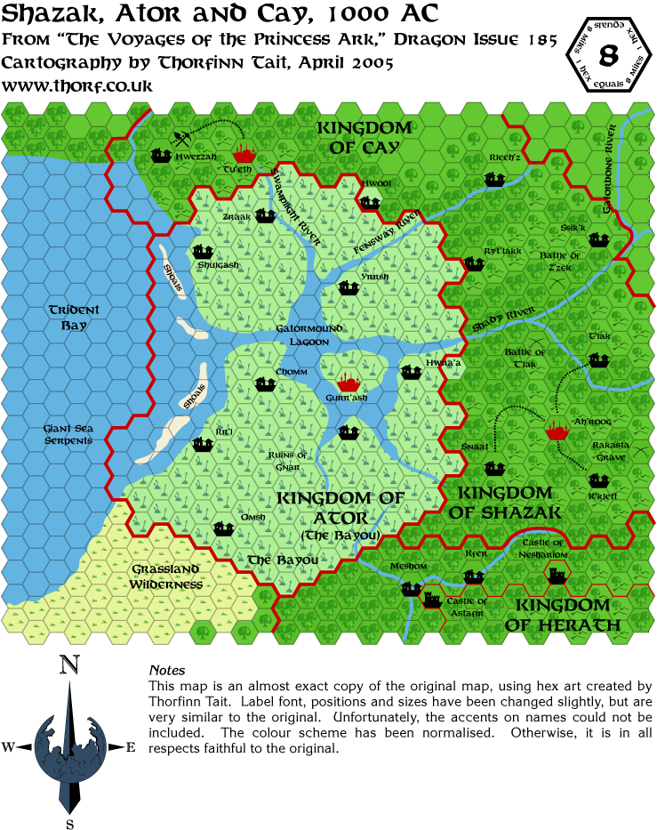
 Wednesday's Map
|

6 April 2005, 08:59 PM
|
 |
Member
|
|
Join Date: Feb 2005
Location: Montreal
|
|
I
assume the Shady River is the border between Shazak and Cay - would it
be appropriate to add a red line running along the river?
|

6 April 2005, 10:24 PM
|
|
Member
|
|
Join Date: Feb 2005
Location: Ontario, Canada
|
|
Quote:
|
Originally Posted by Thorf
<snip image>
|
Another fine map - I can't say how much I appreciate seeing the Savage
Coast maps joined together like this! For me, it was a major letdown,
after buying the Red Steel boxed set, to see that the maps were not in
hex format. I think the ultimate thrill will be to see the whole thing
as one large map, once it's all done.
Geoff
|

6 April 2005, 11:56 PM
|
|
Member
|
|
Join Date: Mar 2001
Location: Twin Cities, MN
|
|
Quote:
|
Originally Posted by Joe Mason
I
assume the Shady River is the border between Shazak and Cay - would it
be appropriate to add a red line running along the river?
|
The Cay-Shazak border is on the Fensway River... according to the Red Steel maps.
|

7 April 2005, 03:04 AM
|
|
Member
|
|
Join Date: Mar 2001
Location: Twin Cities, MN
|
|
Quote:
|
Originally Posted by Thorf
Introducing
a Jungle Hills hex would be nice, but it would also mean a lot of work
judging/guessing which areas should be revised with the new hex.
|
I just noticed that the 72 mile hex map of the Sea of Dread region does
have a jungled hills hex symbol. You can see there that it is used to
mark as jungle hills the forested hills of the Serpent Peninsula. The
same areas that the Champions of Mystara maps show using the regular
deciduous forest hills.
Just an FYI!
|

7 April 2005, 04:36 AM
|
 |
Member
|
|
Join Date: Feb 2005
Location: Montreal
|
|
Quote:
|
Originally Posted by Eric Anondson
The Cay-Shazak border is on the Fensway River... according to the Red Steel maps.
|
In that case that map definitely needs a border line drawn.
|

7 April 2005, 06:23 PM
|
 |
Member
|
|
Join Date: Jan 2005
Location: Akita, Japan
|
|
 Thursday's Map
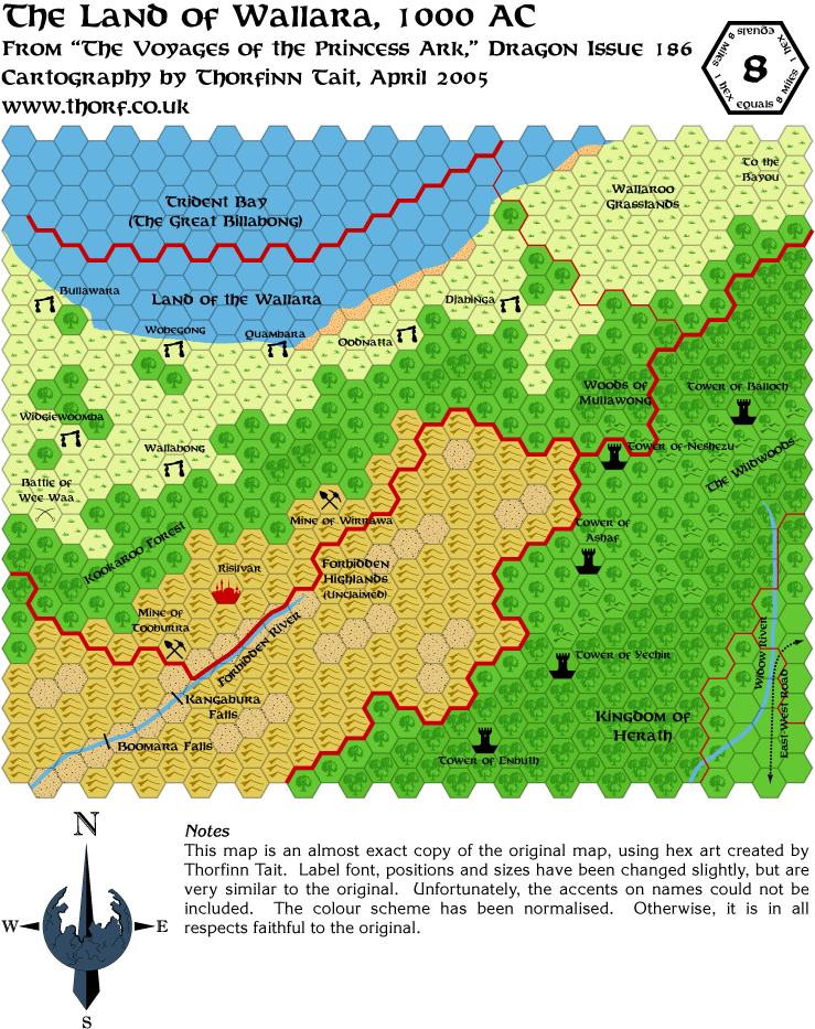
In a hurry again today. I also updated the Herath/reptile kingdoms map with that border from Red Steel and the missing symbol.

|

8 April 2005, 07:59 AM
|
 |
Member
|
|
Join Date: Mar 2004
Location: Ontario, Canada
|
|
Fantastic
work still, Thorf! I really hope you're able to put these Savage Coast
/ Orc's Head maps together it one (or maybe even just two or three)
larger maps. That would be amazingly fantastic!
|

8 April 2005, 12:21 PM
|
 |
Member
|
|
Join Date: Jan 2005
Location: Akita, Japan
|
|
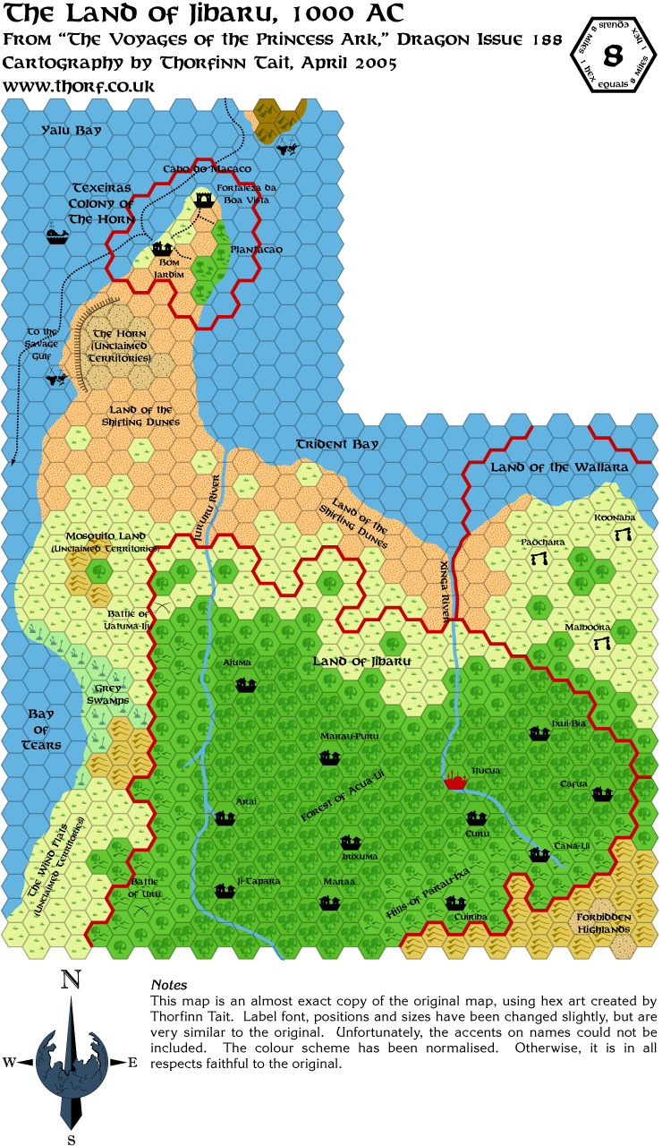
 Friday's Map

I'm currently working on the extended versions of these maps, using Red
Steel and Savage Baronies to fill in the terrain to the north. Things
are going a bit slowly though, due to spending a lot of time at my
mother in law's and also to an Illustrator crash which destroyed two
hours of work two nights ago.  Given all that's happened this week, I really wanted to scream when that happened...
Anyway, when I get home today I will catch up on those two hours again,
and in doing so I'll finish the first pass on the Dragon maps. I'd like
to say it would be quicker the second time, but unfortunately the
legwork on these maps can't really be done any faster.
After that, the next task is to convert the Dragon 196 Orc's Head
Peninsula 24 mile per hex map to 8 miles per hex. Amazingly, this seems
to be the only full map of the peninsula, although parts of it are
shown on Red Steel, Savage Baronies and Orc's Head Peninsula maps.
On the subject of conversion, I think that the towers around Herath
should be expanded to Western Herath. This area has never been shown in
detail on any map - both Dragon 196 and the Savage Baronies map are
large scale maps, and so don't show details like towers. It seems to me
most likely that the line of defence would be maintained, especially
bordering on the orcish tribes of the Orc's Head.
Finally, I'll move on to enhancing the maps with the Red Steel and Savage Baronies non hex maps.
Other tasks currently on my list, in no particular order, include
finishing up the Known World 8 and 24 mile per hex maps, Sind 8 mile
per hex, sorting out the Heldann mess, Wendar 8 mile per hex, Denagoth
8 mile per hex, Norwold 24 mile per hex with terrain properly marked
in, Alphatia and Isle of Dawn 24 mile per hex, a couple of 72 mile per
hex maps, Undersea, Southern Iciria, Azca, Nithia, Milenia, and some
line art maps like the world map and so on.
As you can see, I have enough to keep me busy for the foreseeable future. 
|
|
|