Thorf's Secret Project: Stage One
A recreation of the Mystara Message Board thread that started the Atlas of Mystara project, with restored links and images.

7 March 2005, 10:45 PM
|
 |
Member
|
|
Join Date: Jan 2005
Location: Akita, Japan
|
|
 150th Post!!
|
8 March 2005, 12:45 AM
|
 |
Member
|
|
Join Date: Mar 2004
Location: Stockholm, Sweden. For a while.
|
|
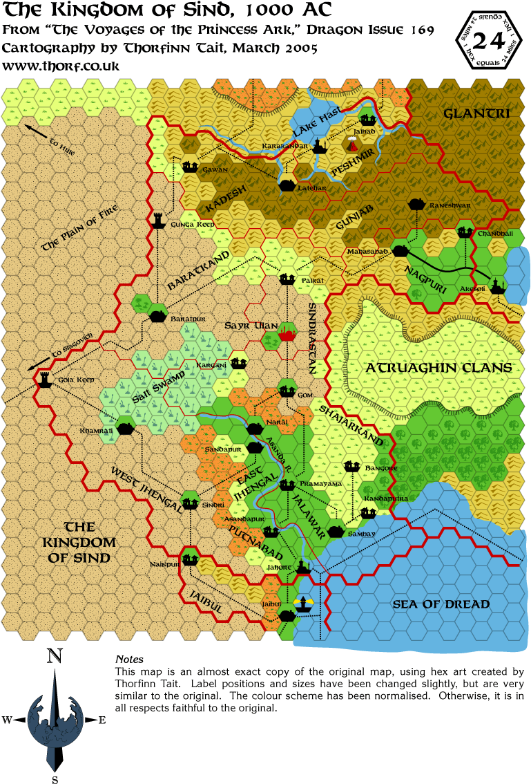
Wow. I always thought Sind was much larger. Interesting.
|
8 March 2005, 12:47 AM
|
|
Member
|
|
Join Date: Jan 2005
Location: Akita, Japan
|
|
 A little experiment
I just had a go at making Ethengar's depressions less hexagonal. Have a look and tell me what you think!
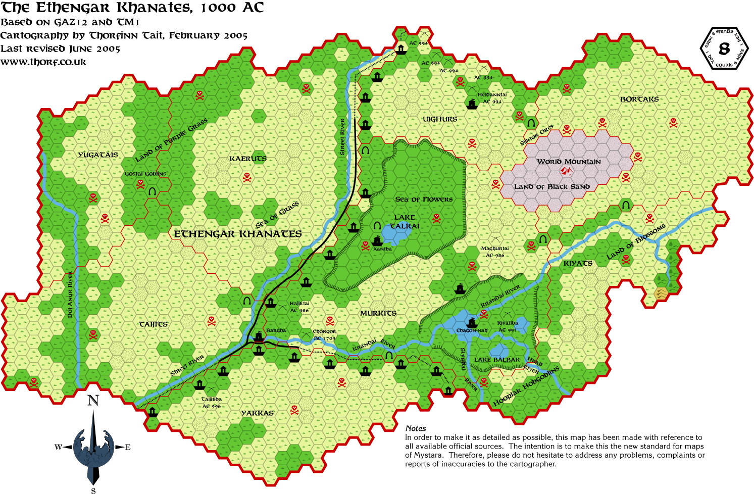
Compare this with the original Ethengar map a few threads back. I made the plateaus look a little less hexagonal,
but I kept the basic shape of the depression, and thus some "hexiness" remains. It would also be possible to
change the shape of the depression quite drastically.
Another option would be to go with the smoother versions from the Wrath of the Immortals 24 mile per hex map, but
I view the 8 mile per hex GAZ12 map as a better source, so I'd rather stick to it as much as possible.
Edit: Since I have now decided to make smooth plateaus the standard in
my maps, I have now replaced the original Ethengar map with the new
curved plateau version. To save space on my site, I won't be posting
the hexagonal plateau versions. If you want a hexagonal plateau version
of a map, please ask me.
Last edited by Thorf : 03-11-05 at 11:48 AM.
Reason: Update on the standardising of smooth plateaus
|
8 March 2005, 12:50 AM
|
|
Member
|
|
Join Date: Jan 2005
Location: Akita, Japan
|
|
Quote:
|
Originally Posted by Lost Woodrake
Wow. I always thought Sind was much larger. Interesting.
|
Remember that this map is 24 miles per hex scale. Consider that since
Sind stretches from the level of central Glantri in the north to
northern Ierendi in the south, on the normal 8 mile per hex scale it
would cover a rather huge area.
|
8 March 2005, 12:55 AM
|
|
Member
|
|
Join Date: Mar 2004
Location: Stockholm, Sweden. For a while.
|
|
Quote:
|
Originally Posted by Thorf
Remember
that this map is 24 miles per hex scale. Consider that since Sind
stretches from the level of central Glantri in the north to northern
Ierendi in the south, on the normal 8 mile per hex scale it would cover
a rather huge area.
|
True. But for some reason I always thought it also stretches much further to the west. 
|
8 March 2005, 01:15 AM
|
 |
Member
|
|
Join Date: Apr 2004
Location: Denmark
|
|
Quote:
|
Originally Posted by Thorf
Remember
that this map is 24 miles per hex scale. Consider that since Sind
stretches from the level of central Glantri in the north to northern
Ierendi in the south, on the normal 8 mile per hex scale it would cover
a rather huge area.
|
Still, I'd love to see an 8-mile hex map of Sind 
:-) Jesper
|
8 March 2005, 02:10 AM
|
|
Member
|
|
Join Date: Jan 2005
Location: Akita, Japan
|
|
You
can actually see an 8 mile per hex map of Sind on Thibault Sarlat's
site already. He made one back in 2000, it seems. It's a nice map.
My own 8 mile per hex Sind map will be coming before too long too. When
I get to it, I'll probably ask for help from those who've already
worked on it - Andrew, Thibault, and anyone else.
For now I still have a lot of official maps still to cover, which I
intend to go through before I start on conversions and such. On the
other hand, there actually aren't that many official maps in total, and
I've probably already covered a good portion of them - perhaps even as
much as half. So it shouldn't be that long.
Edit: I've started work on the Champions of Mystara Great Waste map,
and I'm finding some interesting stuff. It seems to be based on the
original X4 and X5 maps, as well as the Dragon 169 map. It develops on
all those sources, even the Dragon map which was already pretty well
developed. It sorts out problems and discrepancies that had been
created by past maps. Overall, it's a really nice map.
If I have the time to work on it tomorrow, it'll be tomorrow's map.
|
8 March 2005, 02:16 AM
|
 |
Member
|
|
Join Date: Mar 2004
Location: Ontario, Canada
|
|
Quote:
|
Originally Posted by Spellweaver
Still, I'd love to see an 8-mile hex map of Sind |
I'm with Spellweaver on this one! I think Heldann and Wendar would be
nice to see in 8-mile hexes as well. Of course, seeing the Isle of Dawn
in 8 mile hexes would be very impressive.
Quote:
|
Originally Posted by Thorf
I just noticed that the last post I made was the 150th post in this thread. Yay!
|
Wow!!! 
(I came home for lunch today and just couldn't stay off the boards -
this just as bad as wanting my coffee - but I like tea very much too,
Thorf, so send some this way )
Oh ya, I personally like the less hexagonal depressions in the Ethengar map; looks good! (Gotta get back to work)
|
8 March 2005, 02:37 AM
|
|
Member
|
|
Join Date: Dec 2003
Location: Jacksonville, FL
|
|
I too prefer the less "hexagonal" contour lines ...
(are you using the contour-line brush I made for you? Looks like it.)
__________________
Obligatory non sequitur goes here.
|
8 March 2005, 03:00 AM
|
|
Member
|
|
Join Date: Jan 2005
Location: Akita, Japan
|
|
Quote:
|
Originally Posted by katana_one
I too prefer the less "hexagonal" contour lines ...
(are you using the contour-line brush I made for you? Looks like it.) |
I am indeed. Makes drawing the contours just as easy as drawing rivers!
I'm glad the smoother contour lines seem to be going down well. Next I'll have a go at Ylaruam.
One of the benefits of using Illustrator for all this is that scaling
can be done with precision. This means that when I am making my 24 mile
per hex map, some parts I can simply copy out of small scale maps,
shrink them down to the right size, and paste in. Not only does this
save drawing those elements again at the larger scale, but more
importantly it ensures absolute accuracy between the scales.
In other words, my upcoming 24 mile per hex Known World map will be the
first ever to be totally accurate to the 8 mile per hex maps.  
Time for a cup of tea before bed. Anyone want a cuppa? 
|
8 March 2005, 07:45 AM
|
|
Member
|
|
Join Date: Mar 2004
Location: Ontario, Canada
|
|
Quote:
|
Originally Posted by Thorf
Time for a cup of tea before bed. Anyone want a cuppa?
|
Myself, I just get home from work and I have the kettle on already. Thanks anyhow though.
Glad to hear you're going to do the Ylaruam contours as well; keeps the maps "professionally consistant"!
|
8 March 2005, 10:51 AM
|
 |
UnCon Prizewinner
|
|
Join Date: Mar 2005
Location: USA
|
|
Quote:
|
Originally Posted by Thorf
What maps do you want to see?
|
Extending West and South from Sind and Hule, why not the Gulf of
Hule (and nearby Pampa Rica)? Granted, no official hex maps unless you
use the VotPA, alternating 8 and 24 mile scales.
For personal reasons, I'm most interested in seeing a map of the Gulf
of Hule with just terrain, so that I can easily throw some maps
together of the history of the Baronies. 
|
8 March 2005, 12:45 PM
|
 |
Member
|
|
|
|
Quote:
|
Originally Posted by Thorf
What maps do you want to see?
|
Alphatia!
|
8 March 2005, 12:47 PM
|
 |
Member
|
|
Join Date: Apr 2004
Location: Long Beach, CA
|
|
Quote:
|
Originally Posted by Thorf
You
can actually see an 8 mile per hex map of Sind on Thibault Sarlat's
site already. He made one back in 2000, it seems. It's a nice map.
|
It is a very good map- the only problem I have ever noticed on it stems
from the whole Atruaghin Plateau mess. You wind up with certain eastern
regions (such as Chandbali, namely) being far too close to Darokin-
*in* Darokin, actually, which doesn't fit with other 8 mile hex maps of
the region. I think parts of Peshmir were off, too. Again, it stems
from the Atruaghin plateau mixup, so if you discount the easternmost
regions, the rest of the map fits really well with the expanded scale.
|
8 March 2005, 12:53 PM
|
|
Member
|
|
Join Date: Apr 2004
Location: Long Beach, CA
|
|
Quote:
|
Originally Posted by Hugin
I'm
with Spellweaver on this one! I think Heldann and Wendar would be nice
to see in 8-mile hexes as well. Of course, seeing the Isle of Dawn in 8
mile hexes would be very impressive.
|
I've got a lot of the Isle of Dawn mapped out at that scale myself,
though only a few "finished" maps, all based on some things I've done
with certain regions. If you want to take a look, check out http://www.geocities.com/isledawn , in the maps section.
Heldann has been mapped out at 8 mi/hex, initially by Geoff Gander and can be seen at the Vaults here. It would be nice to see done with Thorf's hexes, though. They really look good.
|
8 March 2005, 11:54 PM
|
|
Member
|
|
Join Date: Jan 2005
Location: Akita, Japan
|
|
Tuesday's Map
Thanks for all the input on what to do next.
I spent the evening tonight getting the Champions of Mystara Great Waste map done.
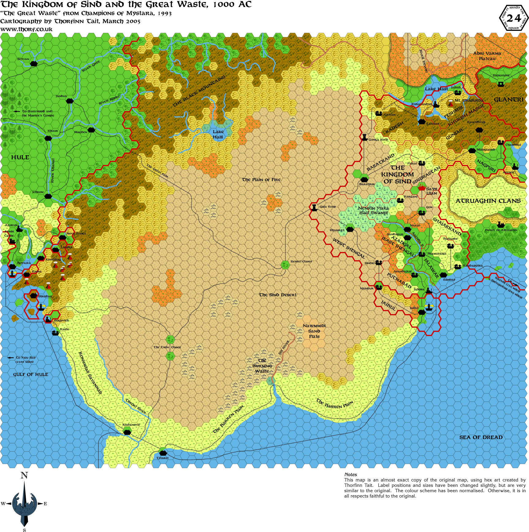
This map is rather interesting. I can tell that a lot of work went into making it, because it brings together elements
from lots of previous maps neatly, sorting out some of the inconsistencies that had cropped up.
|
9 March 2005, 12:21 AM
|
|
Member
|
|
Join Date: Jan 2005
Location: Akita, Japan
|
|
 Eek
Eek
Right after posting, I noticed a few errors. So I have just posted the corrected version.
My palette is rather different from the one originally used on this
map, and as a result it looks a little funny. Particularly, the
badlands in the middle of the desert are somewhat glaring. The hills
also seem to clash slightly, a problem that I noticed on the Shadow
Elves map too. Then of course there's the savannah and swamp colours
which practically glow...
As a result, I'm considering adapting my palette a bit. Most likely I
will make the brighter colours look a little more "washed out". I've
been considering changing my plains green colour to more of a pastel
shade too.
On the other hand, I do like that green. Does anyone have any thoughts
on this? Tweaking the palette is actually a pretty hard job...  
Edit: Here's a quick test I threw together with an example of a washed out palette.
Last edited by Thorf : 03-09-05 at 12:42 AM.
Reason: Added example image
|
9 March 2005, 01:29 AM
|
 |
Member
|
|
Join Date: Jan 2004
Location: Italy
|
|
more nitpicks
Wow Thorf, even more great maps! The continent of Iciria is just an awesome work..
I've noticed two little imperfections in the maps. In the
Wendar&Denagoth you wrote Bengarian's Hermitage, but it's in fact
BenSarian's Hermitage.
In the last one, Sind & Great Waste, I think the right spelling for
the small village near the northern border of the Serpent Peninsula is
not Kladanovit but KladanoviC.
Also, I think you should integrate the Wendar map from X11 with that
presented in PWA1, which showed at least 3 other towns (Sylvair,
Oakwall and Woodgate).
Sorry for the long silence, but I fell ill...
Anyway, keep us updated with your daily life too!
Konnichiwa!
|
9 March 2005, 02:25 AM
|
|
Member
|
|
Join Date: Jan 2005
Location: Akita, Japan
|
|
Quote:
|
Originally Posted by DM
Sorry for the long silence, but I fell ill...
|
Hi Marco, nice to hear from you again. I hope you're feeling better! I've been struggling with a cold here but I'm better now.
Quote:
|
Wow Thorf, even more great maps! The continent of Iciria is just an awesome work..
|
Thanks! It's one of my favourites so far, though it won't be properly
complete until the southern half is done too. Doing all the names on
those two maps is awful, though, because the maps are so dark that the
text is often near unreadable.
Anyway, I'll be doing the second part soon.
Quote:
I've noticed two little imperfections in the maps. In the
Wendar&Denagoth you wrote Bengarian's Hermitage, but it's in fact
BenSarian's Hermitage.
In the last one, Sind & Great Waste, I think the right spelling for
the small village near the northern border of the Serpent Peninsula is
not Kladanovit but KladanoviC. |
Good catch on both of those! 
In my defence, in both cases I copied the mistake from the official
maps. I should really have realised about Bensarian, though.  And Kladanovic seems much more likely than Kladanovit. Oh well...
(On that subject, believe it or not the other Champions of Mystara map, the Serpent Peninsula, has the correct Kladanovic.  )
Quote:
|
Also, I think you should integrate the Wendar map from X11 with that
presented in PWA1, which showed at least 3 other towns (Sylvair,
Oakwall and Woodgate). |
Yep, this is coming in the near future. Wrath of the Immortals also
showed those towns, so I'm probably going to be working from the Wrath
map, with the original X11 map just for reference.
Also, I've begun researching X11's text for extra labels and stuff to add to the map too.
While we're on this topic, I noticed an interesting little issue with
the Naga River. Later maps all have the river running into a cave in
the Mengul Mountains of Denagoth and coming out closer to Heldann. But
actually in X11 the Naga River was supposed to be just a normal river!
The map does feature the break in the river's progress, but only
because of the "Mengul Mountains" caption, which blanks out the terrain
in the area - Naga River included.
Of course, the river flowing underground is cool, so it's a nice
misunderstanding. But it's nonetheless amusing to know how it came
about.
On the subject of the Poor Wizard's Almanac maps, I have indeed been
starting to use those as sources too. Unfortunately they don't have
hexes, but they do help when it comes to placing towns and general
terrain features.
Quote:
|
Anyway, keep us updated with your daily life too!
|
Will do and same to you, Marco.
|
9 March 2005, 03:09 AM
|
|
Member
|
|
Join Date: Jan 2005
Location: Akita, Japan
|
|
One last thing for today...
For
now, I've decided to change the savannah and badlands colours, but
leave the rest as is. I'd like to change the hills and maybe mountains
too, but I haven't found good colours for them yet. Otherwise, I'm
going to keep the palette the same for now, I think.
However, I'm still open to suggestions. 
|
9 March 2005, 03:18 AM
|
|
Member
|
|
Join Date: Apr 2004
Location: Denmark
|
|
Quote:
|
Originally Posted by Thorf
Right after posting, I noticed a few errors. So I have just posted the corrected version.
|
Still are a few errors. The Silt River and the rivers running into Lake Hast are red?
Quote:
Edit: Here's a quick test I threw together with an example of a washed out palette.
|
Liked it better before
Keep up the good work!
:-) Jesper
|
9 March 2005, 07:46 AM
|
|
Member
|
|
Join Date: Mar 2004
Location: Ontario, Canada
|
|
Quote:
|
Originally Posted by Spellweaver
Still are a few errors. The Silt River and the rivers running into Lake Hast are red? |
I think those are meant to indicate a seasonal riverbed; one that dries
up completely during the summer/dry season. We'll find out for sure
once Thorf wakes up
|
9 March 2005, 07:54 AM
|
 |
Member
|
|
Join Date: Feb 2005
Location: Montreal
|
|
Quote:
|
Originally Posted by DM
Also, I think you should integrate the Wendar map from X11 with that
presented in PWA1, which showed at least 3 other towns (Sylvair,
Oakwall and Woodgate).
|
What's PWA1? I can't find it on the "complete product list" at the
Vaults, and every Google hit for it is people mentioning it without a
full title.
|
9 March 2005, 08:12 AM
|
 |
Member
|
|
|
|
PWA1 is Poor Wizard's Almanac Vol. 1. It covers the year AC1010 (I think).
|
9 March 2005, 08:43 AM
|
|
Member
|
|
Join Date: Mar 2004
Location: Ontario, Canada
|
|
Quote:
|
Originally Posted by Traianus Decius Aureus
PWA1 is Poor Wizard's Almanac Vol. 1. It covers the year AC1010 (I think).
|
You think correctly!
|
9 March 2005, 11:10 AM
|
|
Member
|
|
Join Date: Feb 2005
Location: Montreal
|
|
Quote:
|
Originally Posted by Traianus Decius Aureus
PWA1 is Poor Wizard's Almanac Vol. 1. It covers the year AC1010 (I think).
|
Ah, I have that filed as "AC1010". Is PWA1 an official abbrev (like GAZ3 or X4) or is it just a convenient shorthand?
|
9 March 2005, 11:48 AM
|
|
Member
|
|
Join Date: Jan 2005
Location: Akita, Japan
|
|
Quote:
|
Originally Posted by Spellweaver
Still are a few errors. The Silt River and the rivers running into Lake Hast are red? |
Yeah, they're rivers of blood. 
Quote:
|
Originally Posted by Hugin
I
think those are meant to indicate a seasonal riverbed; one that dries
up completely during the summer/dry season. We'll find out for sure
once Thorf wakes up |
Not blood then?
Yes, those are indeed dry/seasonal rivers. Not a very common feature on
Mystara's maps; I think the Champions of Mystara map map may well be
the only example.
Today I'm kinda busy with work, so it's going to be hard to get a map up since I have none in reserve. But I'll do my best.
|
9 March 2005, 12:07 PM
|
|
Member
|
|
Join Date: Jun 2003
Location: Portugal
|
|
Hi!
Thorf, do you by any chance intend to make a map of the city states area on Davania? My current campaign is in that area...
__________________
"They need a 20 to hit me, i'm invincible!!!" - Famous last words
"...the reader should understand that AD&D is designed to be an
amusing and diverting pastime, something which can fill a few hours or
consume endless days, as the participants desire, but in no case
something to be taken too seriously. For fun, excitement, and
captivating fantasy, AD&D is unsurpassed. As a realistic simulation
of things from the realm of make-believe, or even as a reflection of
medieval or ancient warfare or culture or society, it can be deemed
only a dismal failure. Readers who seek the latter must search
elsewhere. Those who desire to create and populate imaginary worlds
with larger-than-life heroes and villains, who seek relaxation with a
fascinating game, and who generally believe games should be fun, not
work, will hopefully find this system to their taste."
E. Gary Gygax, 1e DMG, p. 9
Keep Mystara Alive:
Mystara
Mystara 3e
My races (3.5):
Rakasta
Felian
|
9 March 2005, 12:39 PM
|
|
UnCon Prizewinner
|
|
Join Date: Mar 2005
Location: USA
|
|
Quote:
|
Originally Posted by Thorf
Yes,
those are indeed dry/seasonal rivers. Not a very common feature on
Mystara's maps; I think the Champions of Mystara map map may well be
the only example.
|
On the Orc's Head Peninsula, isn't the Forbidden River south of Risilvar a Billabong?
Edit; Maybe I should research _before_ I post. There are billabongs in
Wallara country, but the Forbidden River isn't one, and the billabongs
aren't on the map.
Last edited by Culture20 : 03-09-05 at 12:49 PM.
|
9 March 2005, 01:28 PM
|
|
Member
|
|
|
|
Quote:
|
Originally Posted by Joe Mason
Ah, I have that filed as "AC1010". Is PWA1 an official abbrev (like GAZ3 or X4) or is it just a convenient shorthand?
|
Just convenient shorthand
|
|
|