Thorf's Secret Project: Stage One
A recreation of the Mystara Message Board thread that started the Atlas of Mystara project, with restored links and images.

11 April 2005, 03:26 PM
|
 |
Member
|
|
Join Date: Jan 2005
Location: Akita, Japan
|
|
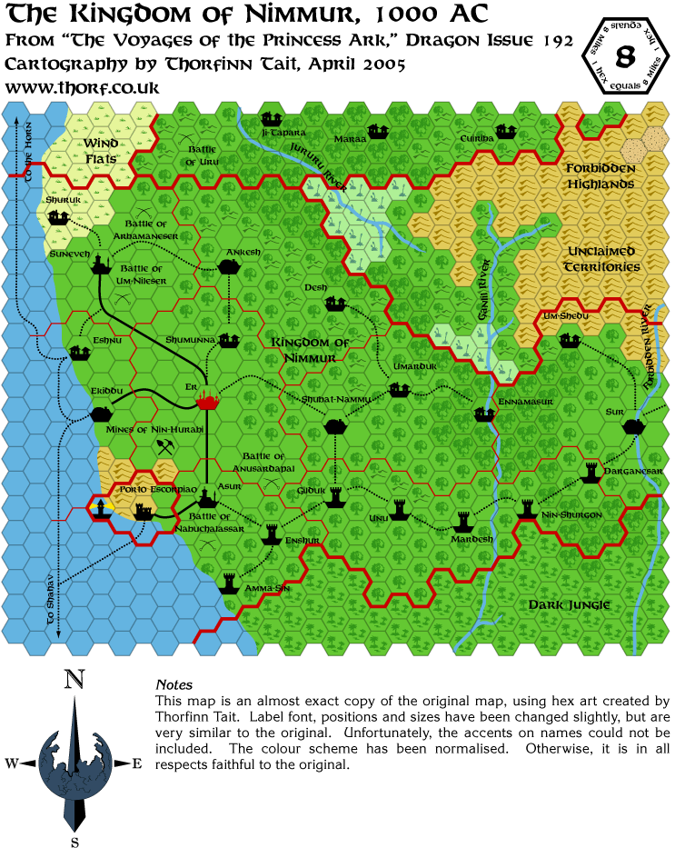
 Monday's Map
Wow, talk about a busy weekend. Thank god weddings are a once in a lifetime event. 
|

12 April 2005, 04:34 PM
|
 |
Member
|
|
Join Date: Jan 2005
Location: Akita, Japan
|
|
 Tuesday's Map
|

13 April 2005, 02:45 PM
|
 |
Member
|
|
Join Date: Jan 2005
Location: Akita, Japan
|
|
 Wednesday's Map
Last edited by Thorf : Today at 04:27 PM.
Reason: Fixed the map URL
|

13 April 2005, 02:50 PM
|
|
|
All
I can say is, you've introduced me to parts of the Known World /
Mystara that I did not know existed. I don't have anything other than
the Gazetteers, and the X1 module. I really appreciate your efforts.
And Congratulations on your wedding.
GW
|

13 April 2005, 05:08 PM
|
 |
Member
|
|
Join Date: Jan 2004
Location: Italy
|
|
 About Nimmur
IIRC,
Um-Shedu should be separated from the rest of Nimmur, since it's been
retaken by the Enduks and it's used as a spearhead to cause problems to
the manscorpions.... or did this happen AFTER AC 1009?? I can't
remember offhand...
And again, congrats on your wedding, Thorf!
Are you still planning it or did you actually get married last week?
|

13 April 2005, 06:45 PM
|
 |
Member
|
|
Join Date: Jan 2005
Location: Akita, Japan
|
|
Thanks
guys! My wedding is in fact on the 8th of May, although we will be
visiting the city hall to actually get married on the 22nd of April -
next Friday! 
I think you're right about Um-Shedu, Marco. All the sources seem to say
it was captured "recently" and "within the last decade". It looks like
it was a Savage Coast setting development. So this map is correct for
1000 AC, but I'll have to change it for the later dated versions.
Thanks for pointing this out, because I had never heard about it
before. I guess I really need to get round to reading the Red
Steel/Savage Coast stuff! 
|

13 April 2005, 10:16 PM
|
 |
Member
|
|
Join Date: Mar 2004
Location: Norway, Europe
|
|
Quote:
|
Originally Posted by Graywolf-ELM
All
I can say is, you've introduced me to parts of the Known World /
Mystara that I did not know existed. I don't have anything other than
the Gazetteers, and the X1 module. I really appreciate your efforts.
|
Want to know more about the Savage Coast?
You can download the Savage Coast products for free at:
http://www.wizards.com/default.asp?x=dnd/dnd/downloads.
Just scroll down to where it says Savage Coast. Make sure you download the stuff under Mystara aswell.
Enjoy! 
Håvard
|

14 April 2005, 12:18 AM
|
|
|
Quote:
|
Originally Posted by havard
Want to know more about the Savage Coast?
You can download the Savage Coast products for free at:
http://www.wizards.com/default.asp?x=dnd/dnd/downloads.
Just scroll down to where it says Savage Coast. Make sure you download the stuff under Mystara aswell.
Enjoy! 
Håvard |
Cool, thanks for the pointer. I'll have my DSL humming tonight.
GW 
|

14 April 2005, 10:13 AM
|
 |
UnCon Prizewinner
|
|
Join Date: Mar 2005
Location: USA
|
|
Quote:
|
Originally Posted by DM
IIRC,
Um-Shedu should be separated from the rest of Nimmur, since it's been
retaken by the Enduks and it's used as a spearhead to cause problems to
the manscorpions....
|
It's only the city; Wouldn't a border designate that they own the whole hex?
|

14 April 2005, 10:59 AM
|
 |
Member
|
|
Join Date: Feb 2005
Location: Montreal
|
|
Quote:
|
Originally Posted by Culture20
It's only the city; Wouldn't a border designate that they own the whole hex?
|
Not necessarily - to me it just indicates that some part of that hex is
separate. (And I'm sure they "own" some land around the city, too, in
the sense that they've gotta patrol it to stop people sneaking up on
them.) I always figure the hex borders are rounding up.
|

14 April 2005, 03:56 PM
|
 |
Member
|
|
Join Date: Jan 2005
Location: Akita, Japan
|
|
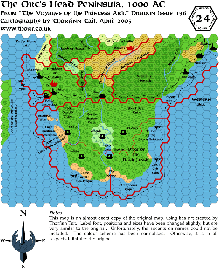
 Thursday's Map
We're approaching the end of the Dragon Savage Coast maps. Just a few more to go after this. 
Last edited by Thorf : Today at 04:29 PM.
Reason: Fixed the map URL
|

15 April 2005, 07:29 AM
|
 |
Member
|
|
Join Date: Jan 2005
Location: Akita, Japan
|
|
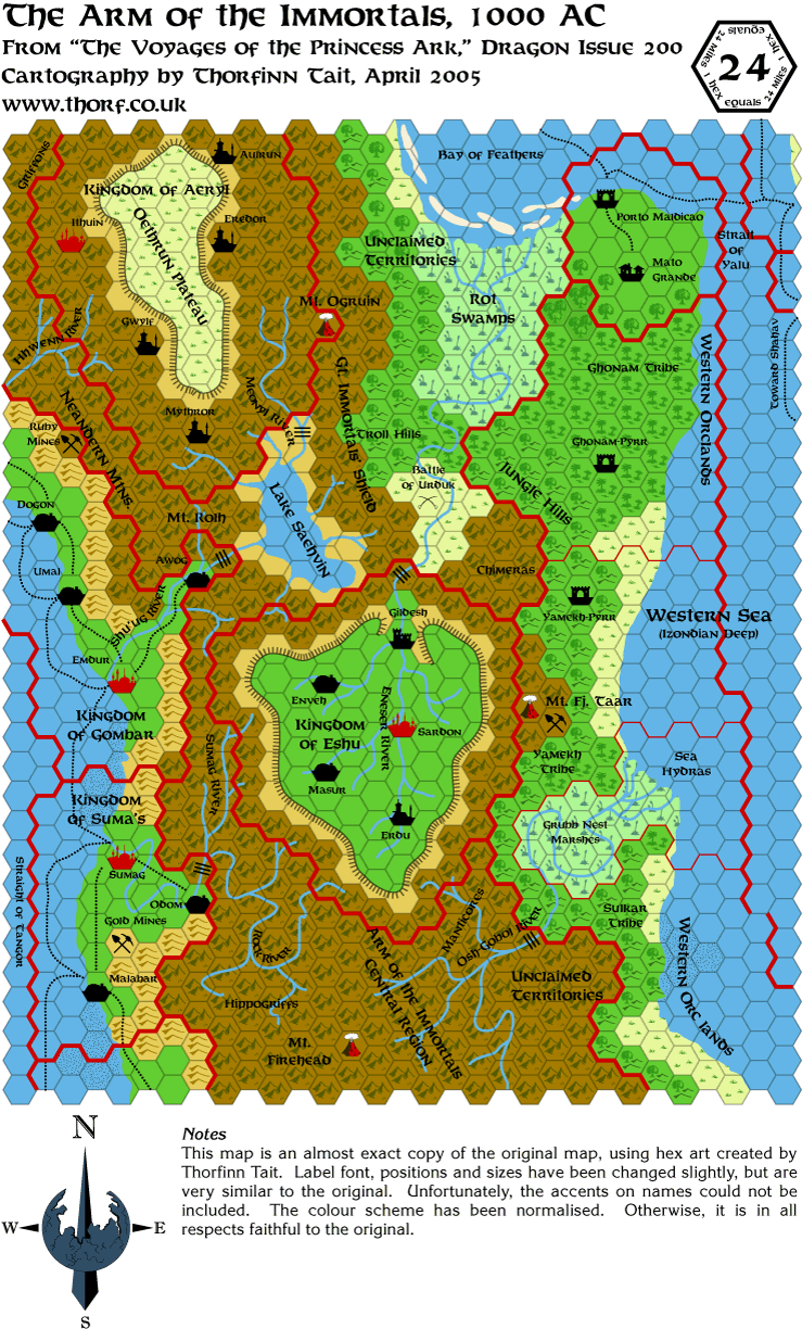
 Friday's Map
A little early, but I don't know if I'll have time later today, so here it is. See you next week!
|

18 April 2005, 02:47 PM
|
 |
Member
|
|
Join Date: Jan 2005
Location: Akita, Japan
|
|
 Monday's Map
Last edited by Thorf : Today at 04:30 PM.
|

18 April 2005, 02:56 PM
|
 |
Member
|
|
Join Date: Jan 2005
Location: Akita, Japan
|
|
 Update
So, that's the end of the Princess Ark maps.  (Those of you who have been paying close attention will note that I actually have yet to do the Yavdlom map.  ) The next stage will be to start enhancing them with the info provided in Red Steel.
I'll be posting two more maps tomorrow and Wednesday, and if I have
time one last one on Thursday. But on Thursday my father arrives, and
I'll be extremely busy with him, wedding plans (I'm making the cake
myself!), etc. for the next three weeks. So I'm going to take another break from posting maps.
I hope to resume posting in mid-May, at some point after my wedding on the 8th. 
|

18 April 2005, 06:17 PM
|
 |
Member
|
|
Join Date: Jan 2004
Location: Italy
|
|
One minor spelling thing: It's Suma'a and not Suma's 
Apart from this: ENJOY your wedding Thorf! We'll leave here best wishes
on the 8th of May for you to read when you'll log in after your
honeymoon is over 
|

18 April 2005, 06:33 PM
|
 |
Member
|
|
Join Date: Jan 2005
Location: Akita, Japan
|
|
Quote:
|
Originally Posted by DM
One minor spelling thing: It's Suma'a and not Suma's 
Apart from this: ENJOY your wedding Thorf! We'll leave here best wishes
on the 8th of May for you to read when you'll log in after your
honeymoon is over  |

I actually noticed that mistake as I posted the map on Friday, and I as
wondering how long it would take for someone to notice. Marco takes the
prize! 
Thanks for the wedding wishes! When all is said and done, there will
doubtless be some pictures on my web site for anyone interested.
(Sometimes there are nice advantages in having a photographer for a
father.  )
By the way, the registry office bit is actually this Friday, the 22nd.  ...  ... 
|

18 April 2005, 09:53 PM
|
 |
Member
|
|
Join Date: Jan 2005
Location: Akita, Japan
|
|
 Illustrator CS Files
I just updated the mapping files for use with Illustrator CS on my homepage. They include all sorts of little goodies now. 
You can see them at my mapping tools page.
|

18 April 2005, 11:44 PM
|
 |
Member
|
|
Join Date: Jan 2005
Location: Akita, Japan
|
|
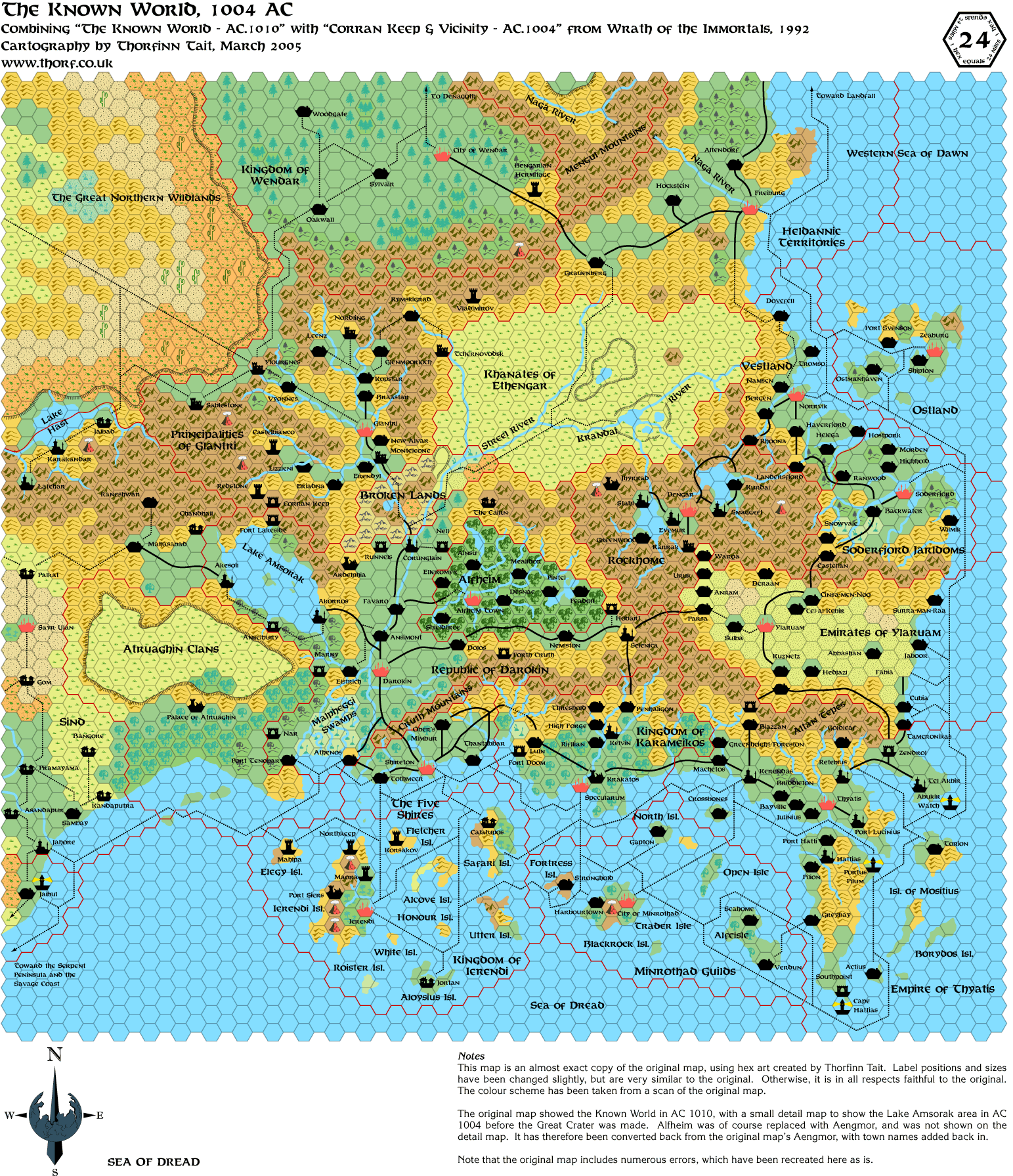
 A little bonus
For a while now, I've been considering implementing the palettes from the original maps in my replica
maps. In most cases, I already have scans of the originals which can be used as sources for the
palettes. It takes a bit of fiddling to do, but in general it's not that hard, and if I were to do it en masse,
I could streamline the process.
So, as a little experiment, I decided to give it a try. I think the result was rather interesting. If you
have access to the original map, please take it out and have a little compare with my map below. Screen
and print are of course inherently different, but I think you'll be surprised at the similarity nonetheless. 
|

19 April 2005, 06:03 PM
|
 |
Member
|
|
Join Date: Jan 2005
Location: Akita, Japan
|
|
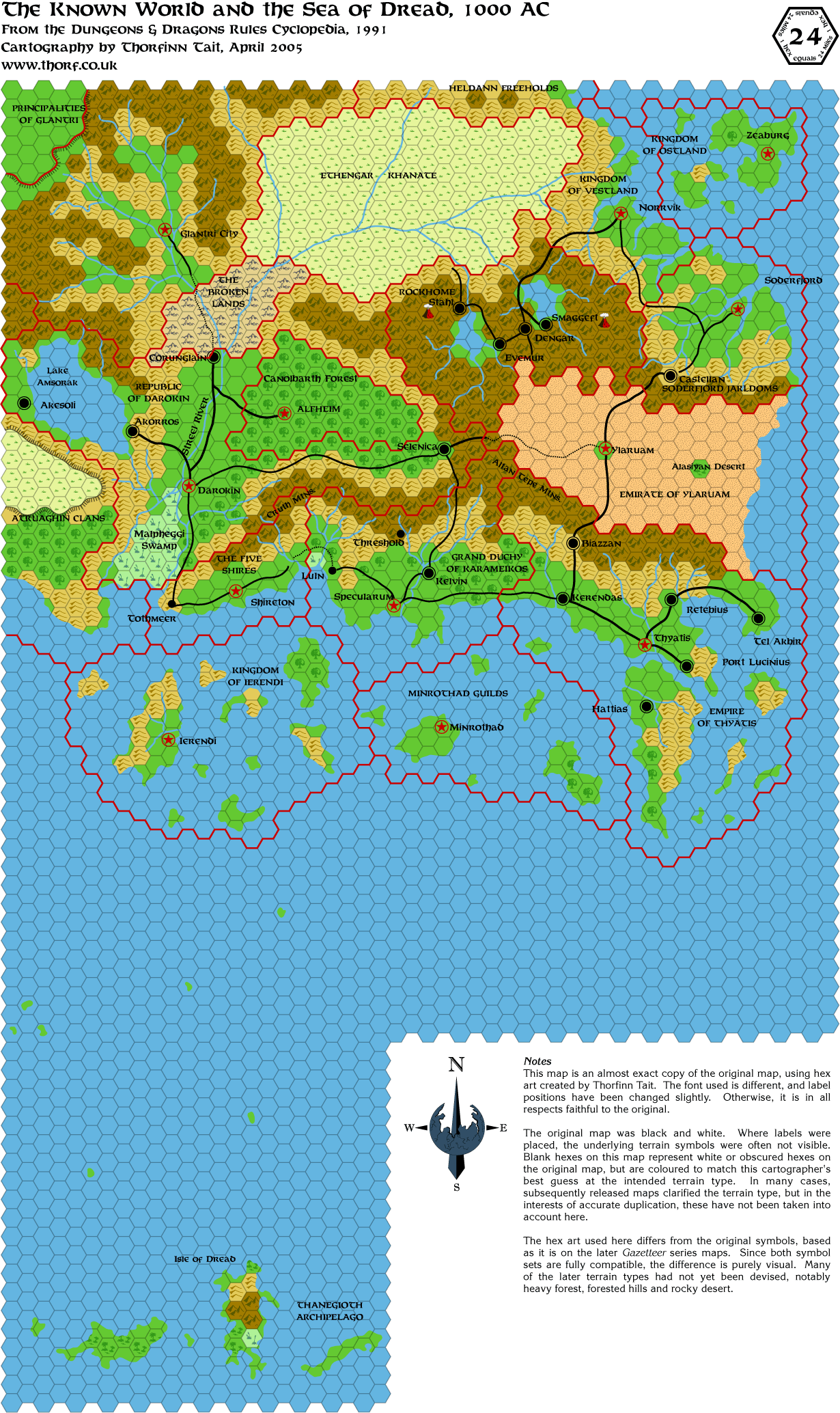
 Tuesday's Map
A while ago I realised that I was wrong about there being no 24 mile per hex Known World map between the Expert Set
and Wrath of the Immortals. I had forgotten the Rules Cyclopedia map, which is an updated version of the Expert
Set map.
|

19 April 2005, 11:26 PM
|
 |
Member
|
|
Join Date: Mar 2004
Location: Norway, Europe
|
|
Awesome maps Thorf! (as usual)
I thought Corran keep was on the Darokin side, but I guess I was misremembering....
I didn't realize the Isle of Dredd was this far west. Something I would
like to see is a map covering both sides of the straight between the KW
and the IoD. I think it would make sense if this sea functions like a
Mystaran Mediterrean Sea. I always wanted a map showing that. If it
could go as far south as to cover the eastern Thanegioth and Ochaela
aswell that would be cool. Anyways, thats for later I suppose as I'm
guessing you have more maps in store for us as part of your project....

Håvard
|

20 April 2005, 02:03 PM
|
 |
Member
|
|
Join Date: Jan 2005
Location: Akita, Japan
|
|
Quote:
|
Originally Posted by havard
Something
I would like to see is a map covering both sides of the straight
between the KW and the IoD. I think it would make sense if this sea
functions like a Mystaran Mediterrean Sea. I always wanted a map
showing that. If it could go as far south as to cover the eastern
Thanegioth and Ochaela aswell that would be cool. Anyways, thats for
later I suppose as I'm guessing you have more maps in store for us as
part of your project....  |
That's a map I'd like to see too. In 24 mile per hex, it's not
especially hard to make, and will be coming in the relatively near
future I hope. 8 mile per hex will take a bit longer...
|

20 April 2005, 02:30 PM
|
 |
UnCon Prizewinner
|
|
Join Date: Mar 2005
Location: USA
|
|
If
you've got good bandwidth and quite a bit of RAM (to open an image this
size), there's an image that Thibault made of most of Mystara at 24
miles per hex. It's one of the controversial ones that fills NW Brun,
and extends the size of Hule, but it's still a neat map. You could
probably look at that for the straight until Thorf makes something
similar.
(not attached as an image since it's 2.9 GB)
http://www.mystara.addr.com/maps/mystara/mystara_24m.png
|

20 April 2005, 02:48 PM
|
 |
Member
|
|
Join Date: Jan 2005
Location: Akita, Japan
|
|
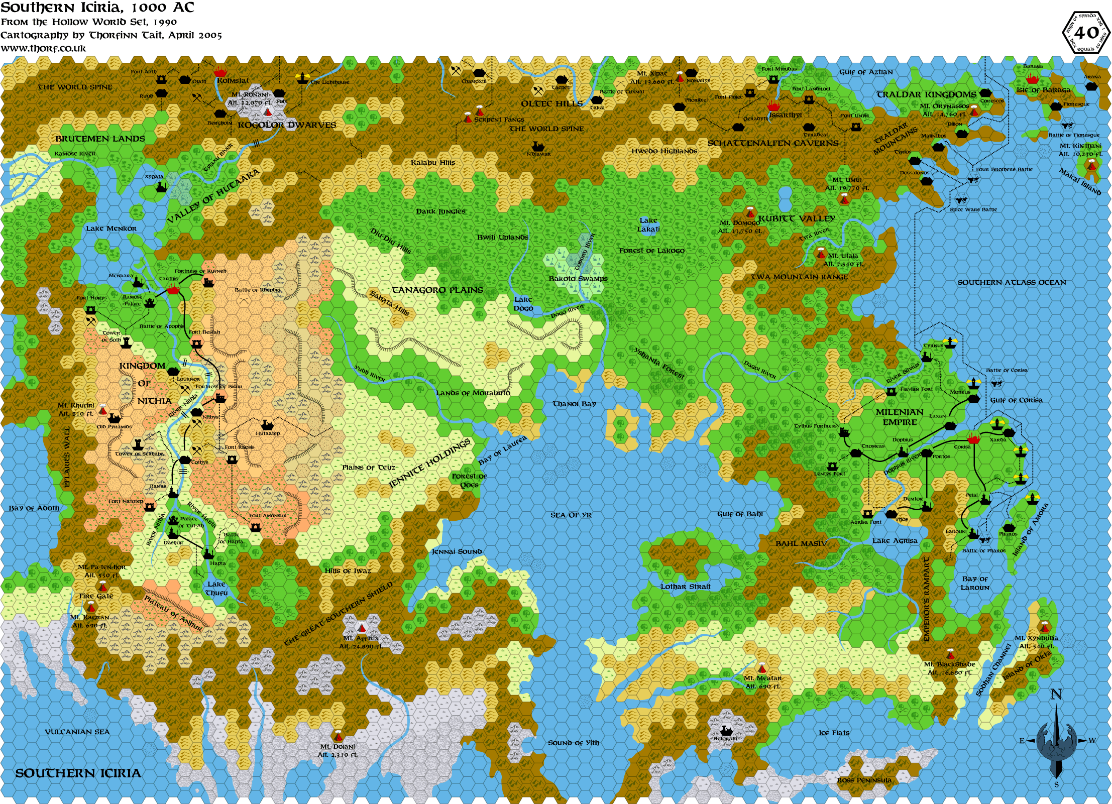
 Wednesday's Map
I thought this would be appropriate to end my second run of maps. Tomorrow will be the combined version
of Iciria! 
|

20 April 2005, 10:04 PM
|
 |
Member
|
|
Join Date: Jan 2005
Location: Akita, Japan
|
|
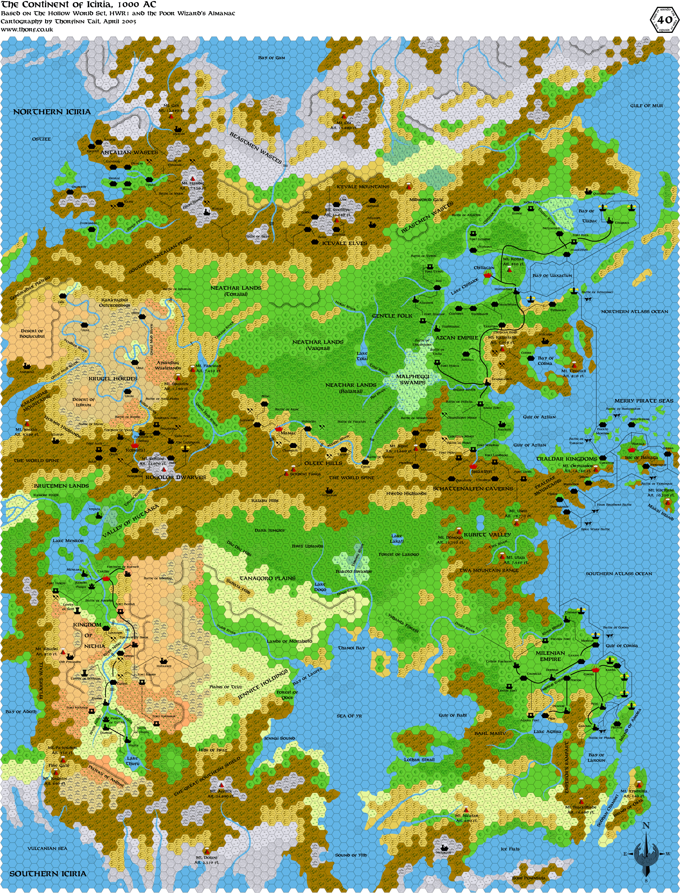
 Thursday's Map
It looks like I might not have time to post this tomorrow, so here it is early! 
|

20 April 2005, 10:15 PM
|
 |
Member
|
|
Join Date: Jan 2005
Location: Akita, Japan
|
|
 Full map of Iciria
It
actually took quite a lot of fiddling to join up the two Hollow World
maps. A couple of rivers were off, but it was clear which version was
more correct in both cases. The major problem came with the Merry
Pirate Seas and the Traldar Kingdoms, though.
I had never noticed just from looking at the maps, but that whole
region is quite different on each map. The coastline is different, and
even the positioning of some towns is different. It's all a bit of a
headache.
In the end, I took the map from the first Poor Wizard's Almanac and
used it to solve the issue, retracing the coastline from it. The result
is somewhat of a compromise between the two maps, although it seems the
southern map was always more accurate.
The next step for this map, in the long run, is to overlay it with the
Hollow World world map and use it to fill in the missing parts of
Iciria, and of course the rest of the continents too. First attempts at
lining up the two maps have proved a little difficult, which might
indicate that the hex map and the world map are not fully accurate. For
now it's too early to tell for sure, though.
So, this brings my second batch of maps to an end. If all goes well, I
will start posting maps again in the middle of May. Please keep your
fingers crossed! 
Thanks for sticking with me this far.       
|

20 April 2005, 11:01 PM
|
 |
Member
|
|
|
|
Quote:
|
Originally Posted by Thorf
I just updated the mapping files for use with Illustrator CS on my homepage. They include all sorts of little goodies now. 
You can see them at my mapping tools page. |
Thorf, I'm having some trouble with your files. I downloaded both
versions over the weekend, and just now downloaded your updated version
for CS. In CS the only files that work OK are the templates (prev. one
was green hexes, new one is blank hexes). The other files open, but
nothing shows after opening them! I was able to open your 8.0 file in
CS and use those hexes, but I'm eager to see all the goodies for CS!
Has anyone else had issues with this?
Anyone have any idea what might be causing this?
Any help would be much appreciated!
Dan
|

21 April 2005, 12:12 AM
|
|
Member
|
|
Join Date: Mar 2001
Location: Italy
|
|
Quote:
|
Originally Posted by Thorf
So, this brings my second batch of maps to an end.
|
And what a grand ending! Iciria!
Well, best wishes!
GP
|

21 April 2005, 12:27 AM
|
|
|
Have a great couple of weeks, Thorf.
Best wishes for this Friday and May 8th! 
|

21 April 2005, 10:27 PM
|
 |
Member
|
|
Join Date: Jan 2005
Location: Akita, Japan
|
|

Quote:
|
Originally Posted by DanEustace
Thorf,
I'm having some trouble with your files. I downloaded both versions
over the weekend, and just now downloaded your updated version for CS.
In CS the only files that work OK are the templates (prev. one was
green hexes, new one is blank hexes). The other files open, but nothing
shows after opening them! I was able to open your 8.0 file in CS and
use those hexes, but I'm eager to see all the goodies for CS!
|
I think I know what you're doing wrong. The files for symbols,
swatches, patterns, and so on - everything other than the template file
- need to be loaded up from their appropriate control panel. For
example, to load the symbols, click on the symbol palette, then on the
menu arrow at the top right of that panel. At the bottom is a "Load
symbol palette..." command, which you can use to bring up extra symbol
palettes. You can then make that palette persistent, or just add all of
the symbols to your document's main symbol palette.
In other words, those extra files are not in fact full Illustrator
files at all. All they contain is the palettes, which is why they
appear blank.
Your feedback answers a question I was wondering about, which is how
well my template transfers to other computers. It seems that a better
idea would be to simply add all the symbols to the template's symbol
palette, rather than storing them in different files. However, doing
that makes choosing symbols very clumsy.
I hope that helps you to get things working!
|

22 April 2005, 05:59 AM
|
 |
Member
|
|
Join Date: Apr 2004
Location: Denmark
|
|
Thanks for all the great maps and best wishes for tomorrow!
:-) Jesper
|
|
|