Thorf's Secret Project: Stage One
A recreation of the Mystara Message Board thread that started the Atlas of Mystara project, with restored links and images.

Jun 21, 2005 10:40:04
|
 |
|
|
Join Date: Jun 2003
Location: Liverpool, England
|
|
and more posts than the whole Birthright message board. :bounce:
Regards,
Gary
|
Jun 21, 2005 11:19:15
|
 |
|
|
Join Date: Jan 2005
Location: Akita, Japan
|
|
LOL...
Actually I was noticing that this thread is gradually approaching a tenth of the size of the whole Mystara forum...  |
Jun 21, 2005 18:40:15
|
 |
|
|
Join Date: Sep 2003
Location: Malpheggi Swamp near the Darokin border
|
|
Of course. It is full of wonderful maps and suggestions. One of the most useful threads for setting up a campaign. Thanks for all the hard work!
|
Jun 22, 2005 0:44:37
|
|
|
|
Join Date: Jan 2005
Location: Akita, Japan
|
|
I filled in the space where the legend was using my own judgement with reference to the 40 mi per hex map,
and I also adjusted the coastline there to be more consistent with the 40 mi per hex map and added some details
to it. (Most of the coastline of course cannot be seen on this map, but eventually I'll make additional maps to
cover the surrounding areas.)
|
Jun 22, 2005 10:27:58
|
|
|
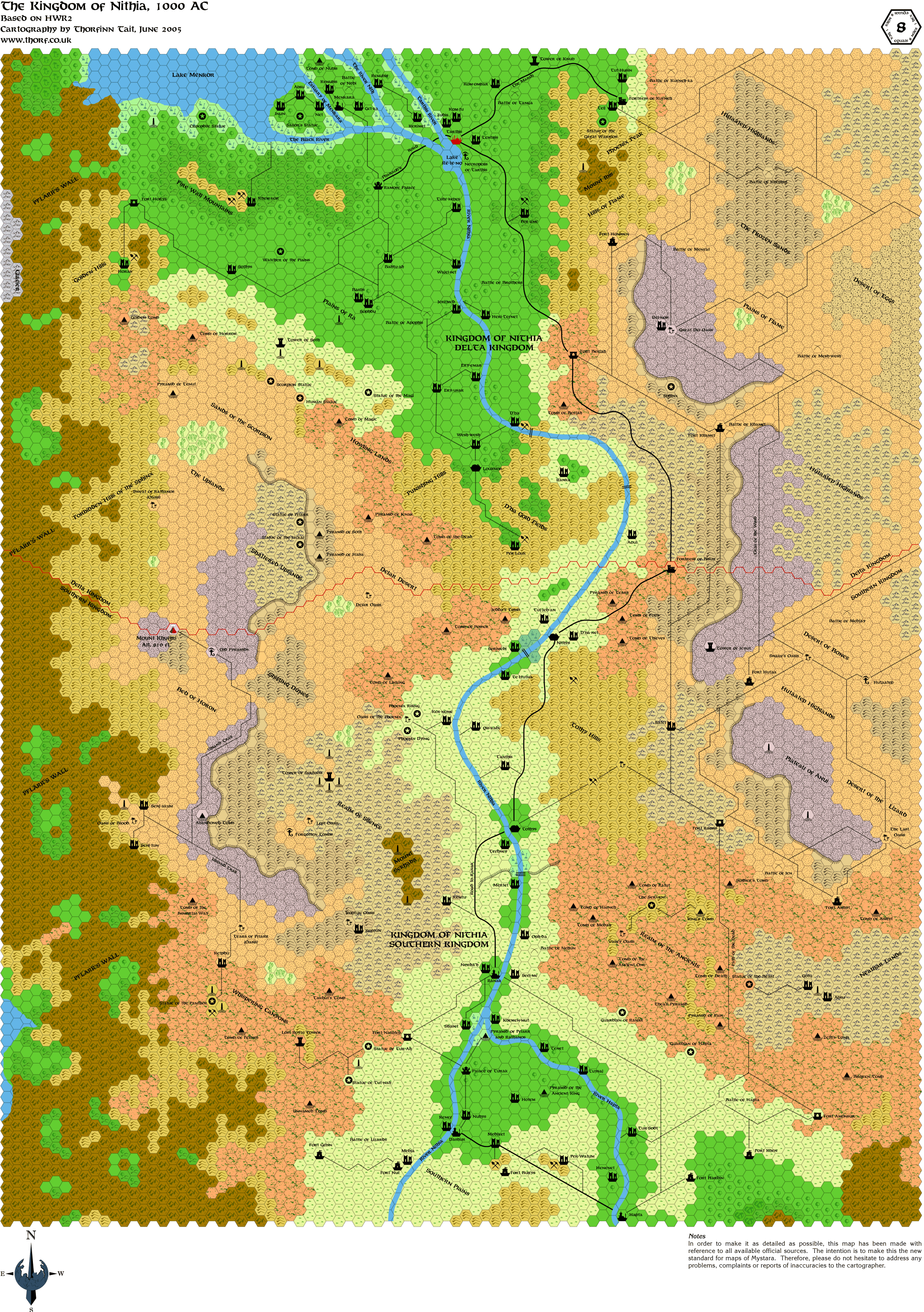
Did you just put your 2 Nithia's maps together ?
I really would like to see a huge map made with every of your 8 miles per hex maps. I'm sure it would be awesome.
By the way, you posted new maps, but did you update the index ?  
I won't be able to do any updates from thursday 10:00 PM (GMT +2) till the 4th of July and i would like to do the stuff before leaving.
I changed a little bit the presentation which will be the definitive one i guess.
A new design for nice maps |
Jun 22, 2005 11:01:37
|
 |
|
|
Join Date: Mar 2004
Location: Norway, Europe
|
|
Shuguy: Nice piece of webdesign!
Thorf: Excellent Nithia map! I never noticed the location saying Tomb of Horrors there before.... 
Håvard |
Jun 22, 2005 21:26:05
|
|
|
|
Join Date: Jan 2005
Location: Akita, Japan
|
|

No time right now, replies later.
|
Jun 24, 2005 21:12:10
|
|
|
|
Join Date: Jan 2005
Location: Akita, Japan
|
|
I tried to post this yesterday but couldn't access the boards all day. 
 |
Jun 24, 2005 22:23:50
|
 |
|
|
Join Date: Mar 2004
Location: Ontario, Canada
|
|
Wow! I'll bet there was no small amount of work put into this one, eh? Well done! Btw, the boards were acting up for as well.
|
Jun 25, 2005 0:08:45
|
|
|
|
Join Date: Jan 2005
Location: Akita, Japan
|
|

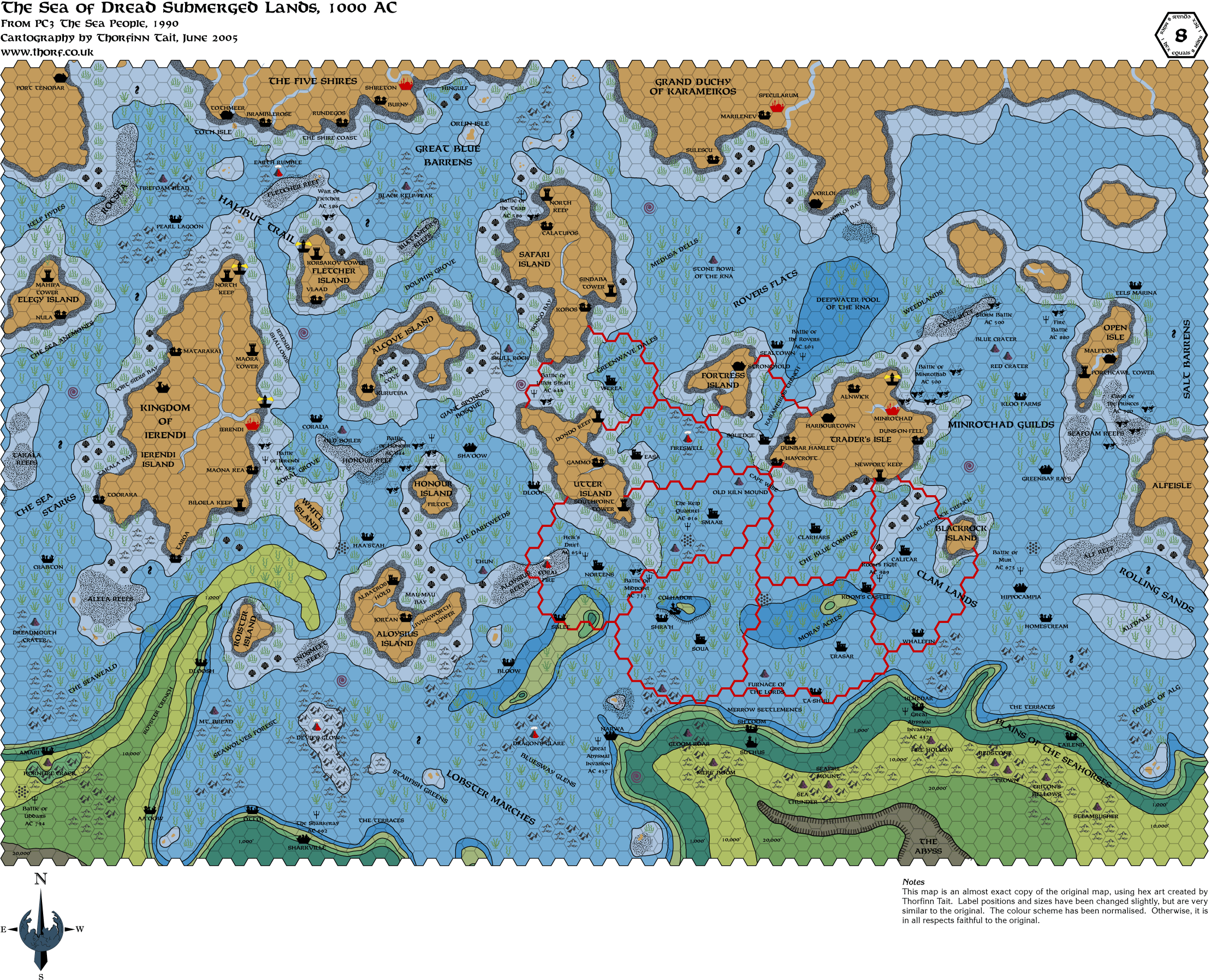
I'd have to say that making the Oyster Fields symbol was the biggest challenge. After that the Underwater Battle trident symbol was also a little difficult. But making the ruined city, town and village symbols was really fun - just take the existing symbol and add cracks, knock down towers, etc. Fun fun fun!! 
The map itself posed an unexpected difficulty in that, for reasons I have yet to work out, it caused my computer to come grinding to a halt. So doing the last few bits of work on the map took hours longer than I expected.
The best thing about this map, though, is that I can use it to revise the coastlines and shallow water/deep water lines of all of the relevant surface lands - Atruaghin, Darokin, the Five Shires, Karameikos, Thyatis, Ierendi and Minrothad. What's more, it shouldn't be too hard to make similar maps for other underwater areas using this one as a base. At the very least, I am going to complete the top right corner of the map, which is where the Legend was on the original.
Actually I just checked, and it seems I forgot to delete the corner on this map.  So you can already see the first steps of detailing that corner. All it needs now is some kelp and sea grass, and possibly another feature or two to round out the area. I'm not sure when I will do this, though. It might be next week, but I don't want to spend much more time on this map right now.
So what's next? Well, I'm rapidly running out of source material! I still have a few big maps to do, notably HWR1 Azca and HWR3 Milenia, and all the 72 mi per hex maps (Dawn of the Emperors and the three Poor Wizard's Almanacs). Then there's the 48 mi per hex Wrath of the Immortals map, but it has never been a high priority. I have yet to do Yavdlom at 8 mi per hex from Dragon 170 and Champions of Mystara, the City of the Stars at 2 mi per hex from GAZ13, the Valley of Wolves from PC4... That's about it, I think.
After that I have a lot of conversion work to do, with the Red Steel/Savage Baronies maps (currently waiting on photographs of these from my dad, which will hopefully solve all my scale and orientation problems with the maps), as well as making more detailed maps for various areas, including 24 mi per hex for the whole known area of the Outer World (some areas were missed out), and of course expanding the Iciria map to cover the whole Hollow World, and converting that down to 8 mi per hex for the rest of Iciria.
Once all that is done, I might be well enough done to announce Stage Two of my project, although I have a feeling it's going to be a bit of an anticlimax after Stage One.  |
Jun 25, 2005 0:50:15
|
 |
|
|
Join Date: Jun 2005
Location: Uruguay
|
|
Does "Stage 2" involve some creative filling in of all the regions that DON'T have 8 mi hex maps, ie. making your own 8 mi detailed hex maps for them?
Because that would be even far more useful than the already wonderful work we've seen in stage one!
RPGpundit
|
Jun 25, 2005 16:17:42
|
|
|
|
Join Date: Sep 2003
Location: Malpheggi Swamp near the Darokin border
|
|
I hope all maps in 8 mile hex is the plan, becasue I was thinking of doing it myself, but I'd have to do it by hand. I don't have a program that hex maps, only does it in diamond patterns and that's worthless in mapping for RPG's.
|
Jun 26, 2005 11:02:28
|
|
|
Any chance of seeing maps like these made of the old home-brews by Geoff Gander (colored pencil maps) and/or Thibault Sarlat (DOS hex-mapper maps)? Both of them covered lots of areas (OW & HW) that TSR never touched. Unless that's "stage 2."
|
Jun 26, 2005 12:04:45
|
|
|
Join Date: Apr 2005
Location: Seattle area
|
|
Quote:
|
After that I have a lot of conversion work to do, with the Red Steel/Savage Baronies maps (currently waiting on photographs of these from my dad, which will hopefully solve all my scale and orientation problems with the maps), as well as making more detailed maps for various areas, including 24 mi per hex for the whole known area of the Outer World (some areas were missed out), and of course expanding the Iciria map to cover the whole Hollow World, and converting that down to 8 mi per hex for the rest of Iciria.
|
Thorf,
Do you still have any interest in borrowing my copies of the Red Steel / Savage Baronies maps? Haven't heard from you on the subject since I originally made the offer.
Gordon
|
Jun 27, 2005 1:40:07
|
|
|
|
Join Date: Jan 2005
Location: Akita, Japan
|
|
Gordon, I'm sorry I forgot to contact you.  As it happens I was able to get a hold of some copies of Red Steel and Savage Baronies, and I'm getting my father to photograph the maps for me. So thanks again for your very kind offer, but I don't need to borrow your maps.
As for Stage Two... Well, originally Stage One was supposed to be mapping, and Stage Two was something different. I am considering revising this to make Stage Two "unofficial" mapping, and move the present Stage Two to Stage Three, but I haven't decided yet. I may just leave Stage One ongoing even after I announce Stage Two.
And yes, I have always intended to map as much of the world as I possibly can. As I've been saying, the official maps are just the starting point - primary sources. After I have exhausted all of them, I will move on to using derivations of them (scale conversions incorporating my own judgement), as well as other fan-made maps - secondary sources.
I'm afraid there probably won't be many maps this week, by the way. This weekend there was a dance festival here in Akita City, and I spent the whole weekend taking photos of my wife dancing. I'm working on mapping again today, though, so I might have something for you later in the week. |
Jun 28, 2005 1:55:57
|
 |
|
|
Join Date: Jan 2004
Location: Italy
|
|
Well Thorf, keep on dancing and making love to your wife whenever you have the time: remember that D&D is still a PASTTIME, not a full time job (not for us at least)
Oh, just a quick comment on the UNdersea map: I found VERY hard to read the tags which were written in the "reef" areas. COuld you either write them outside the "reef" hexes or find some other solution to make them more readable? |
Jun 28, 2005 7:34:55
|
|
|
Join Date: Feb 2005
Location: Ontario, Canada
|
|
I must have missed this earlier, but IIRC, Gwondoya is actually in ruins on the VotPa map.
Geoff
|
Jun 28, 2005 7:46:36
|
|
|
|
Join Date: Jan 2005
Location: Akita, Japan
|
|
Marco - thanks for your words of encouragement. 
Also, I agree with you about the reefs on the Undersea map. I was so worried about the sand around the islands obscuring text that I forgot to check the reefs. I'll sort them out when I get round to updating the map properly.
Geoff - great catch! You are absolutely right, and I would probably have never noticed that mistake. Thanks!  |
Jun 29, 2005 8:48:04
|
|
|
|
Join Date: Jun 2003
Location: Liverpool, England
|
|
Thorf,
I realise that it would require a good deal of work  , and may even go against the spirit of using hexes in the first place  , but have you considered smoothing out the edges of forests, mountain ranges, borders, etc. in a fashion similar to what you did with GAZ13's cavern walls?
Of course, it would also mean me downloading all the maps again.
Regards,
Gary |
Jun 29, 2005 9:58:22
|
|
|
|
Join Date: Jan 2005
Location: Akita, Japan
|
|
I have indeed, but it's not really very compatible with hex maps. I would have to give up on the current hexes and design some new kind of pattern that could handle having the edges cut. It might be simpler just to change the mapping style altogether and make non-hex maps.
Which is actually not as unlikely as you might think. Eventually I'm going to need various types of maps for my project...  |
Jun 29, 2005 10:11:20
|
|
|
|
Join Date: Jun 2003
Location: Liverpool, England
|
|
Don't forget to put the 8 mile Wendar map in the index!
Gary
...just noticed this is 500th reply to the thread. :bounce: |
Jun 29, 2005 10:15:25
|
|
|
|
Join Date: Jan 2005
Location: Akita, Japan
|
|
Woohoo!! We passed 500 posts! 
By the way, the Wendar map won't be added to the index until it's finished. That's one reason that I started a separate thread for that discussion. |
Jul 01, 2005 9:06:28
|
|
|
|
Join Date: Jan 2005
Location: Akita, Japan
|
|
Well, it seems my daily updates have really come to an end. There's just too much work to be done on each map now, what with scale conversions, developing new areas and so on. I will post the last few replica maps and their updated versions over the next few weeks (months?), as I get them done.
For the conversions, I will be soliciting contributions just like I have been doing this week for Wendar. I'll start a new thread for each map, and when everything is done, the final version will be added to this thread. I think we can probably get one map done each week using this method. Your contributions are vital to keeping up the pace of my mapmaking! I really appreciate all the help.
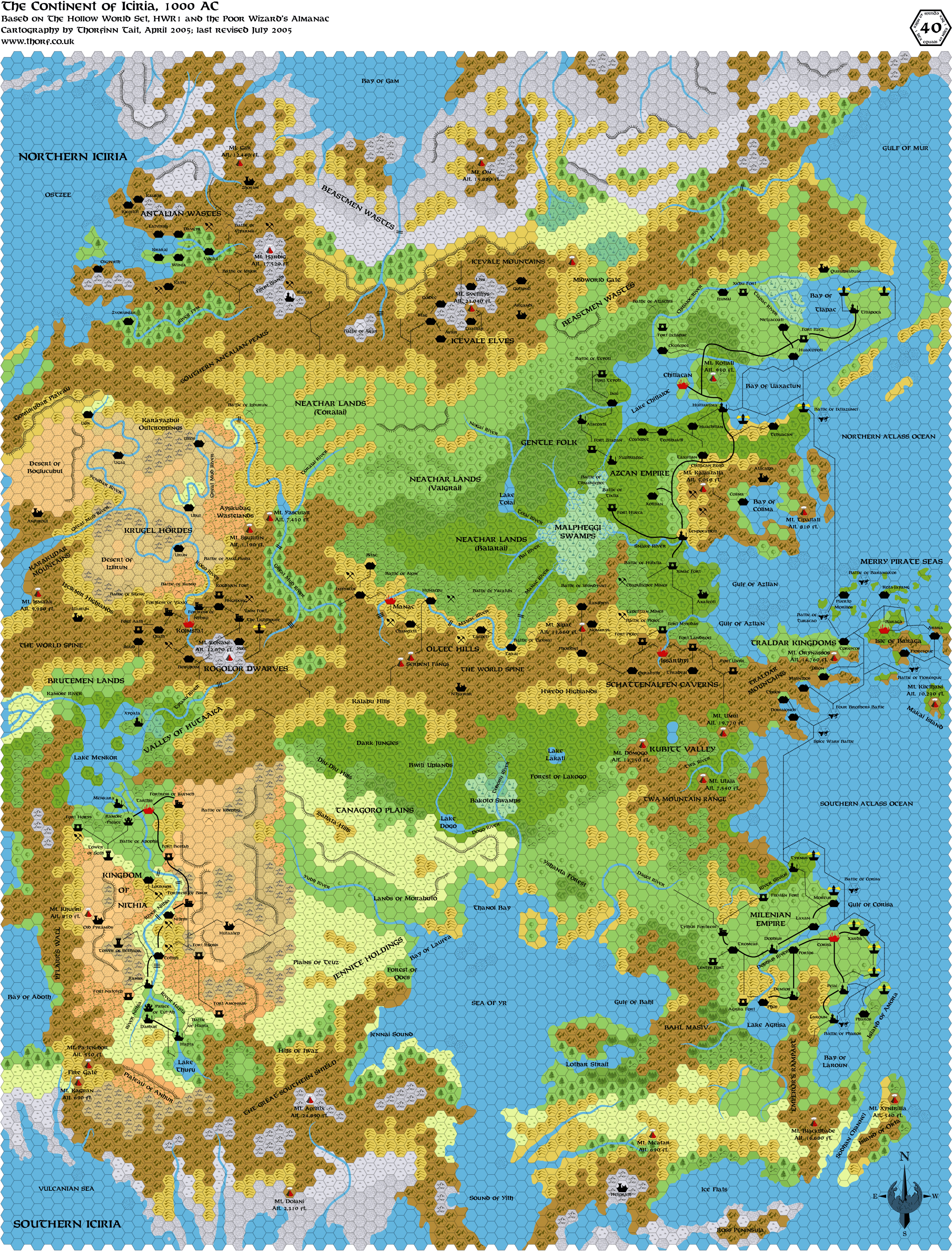
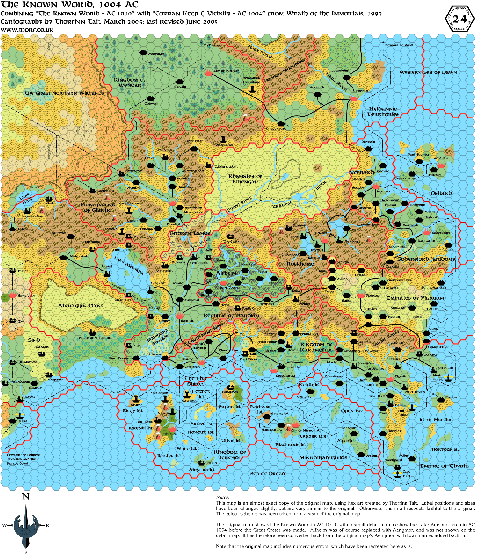
By the way, I have just updated the original palette version of the Wrath of the Immortals 1004 AC 24 mi per hex map, and also the full Iciria map. On the Iciria map I have done some tweaking, fixed a lot of heavy forest and forested hills tiles, and changed some of the forests to evergreen. I'm going to repost it below for your viewing pleasure, please tell me what you think about the evergreen forest distribution. (It's loosely based on the HWR3 Milenia map, which showed evergreen forests in the far south of Milenia.) |
Jul 01, 2005 9:07:52
|
|
|
|
Join Date: Jan 2005
Location: Akita, Japan
|
|
|
Jul 04, 2005 7:41:32
|
|
|
|
Join Date: Jan 2005
Location: Akita, Japan
|
|
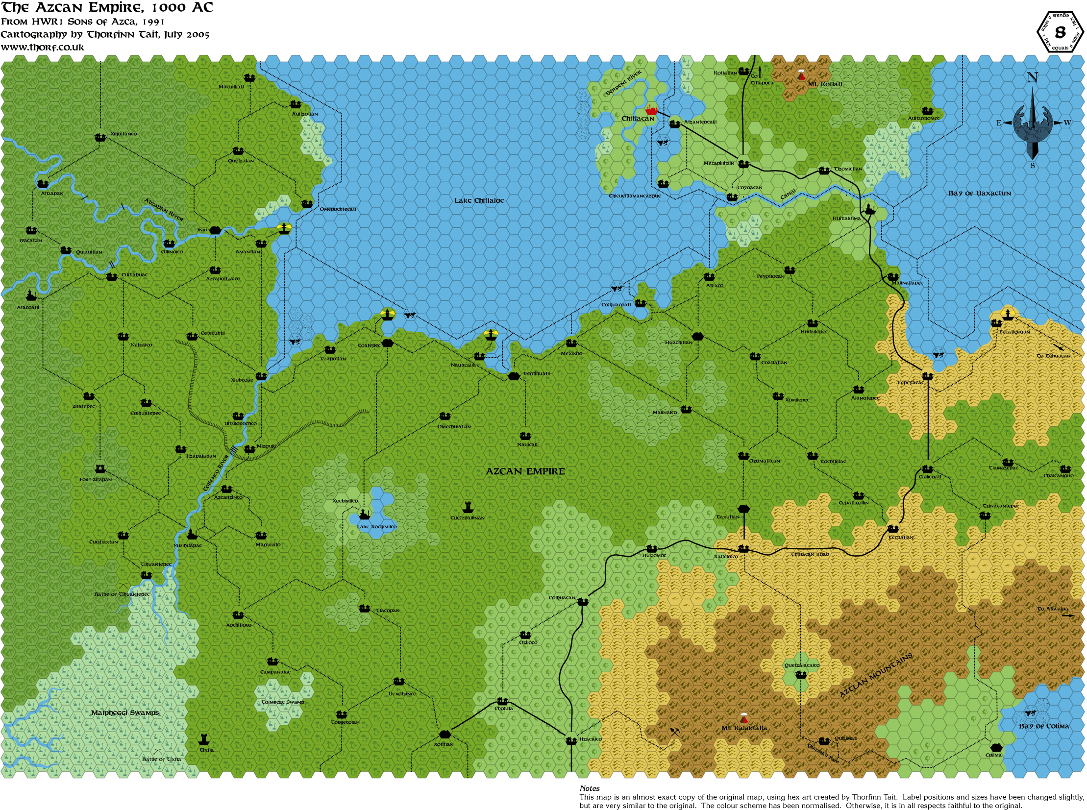
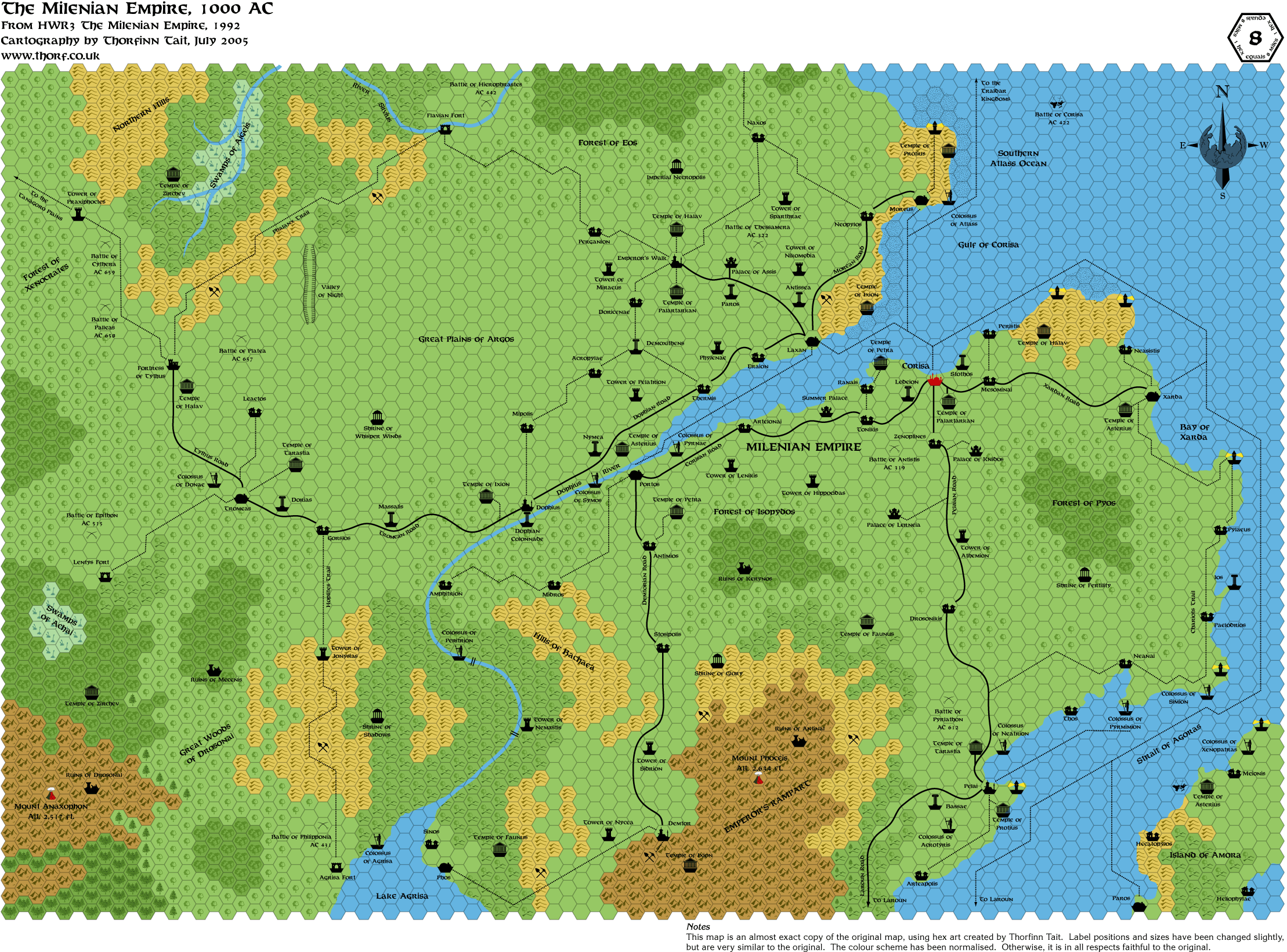
In fact this map only shows the central part of the Empire, which spreads over a rather large area. More of this later.
|
Jul 04, 2005 22:09:37
|
|
|
|
Join Date: Jan 2005
Location: Akita, Japan
|
|
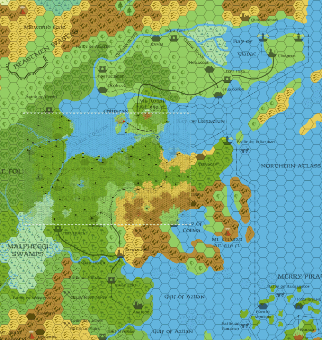
Here's the 8 mi per hex map overlaid on the 40 mi per hex map, so you can see just how big the Empire is.
 |
Jul 05, 2005 6:58:53
|
|
|
|
Join Date: Jun 2003
Location: Liverpool, England
|
|
It's funny how you notice things!
With the 8 mile grid overlaid on the 40 mile hex scale map, I noticed, because of the scale, the rivers are about 8 miles wide for the majority of their length.
Not really relevant, but it's just something I've never even thought about before.
Regards,
Gary |
Jul 05, 2005 22:28:10
|
|
|
|
Join Date: Jan 2005
Location: Akita, Japan
|
|
There are only a couple more Hollow World maps left to do now - Ashmorain and Shajapur from HWA2 and HWA3, and I
can't think of any others.
Regarding the rivers, that thought has occurred to me, yes. Especially on the smaller scale maps, the width of the rivers
is hugely exaggerated. Even on the large scale maps they are too thick. I've considered shrinking them down, but I
haven't tried it yet. I do want to standardise the widths at some point, though - currently on my maps there is some
variation between maps.
|
Jul 05, 2005 22:53:23
|
|
|
|
Join Date: Mar 2004
Location: Ontario, Canada
|
|
Quote:
|
...the width of the rivers is hugely exaggerated.
|
I always assumed that the exaggeration was merely for purposes of clearity. It doesn't show any of the river's finer meanderings or width variations. I guess you could say it's a rough guide in the same manner that the hex symbols are a rough representation of the area's terrain.
That Azcan overlay map was very interesting there, Thorf. Really puts it in perspective, eh!
|
Jul 06, 2005 0:43:11
|
|
|
|
Join Date: Jun 2005
Location: Uruguay
|
|
Quote:
|
There are only a couple more Hollow World maps left to do now - Ashmorain and Shajapur from HWA2 and HWA3, and I
can't think of any others.
|
Are you also planning to do all the maps from the surface gazeteers or the Poor Wizard's Almanac?
RPGpundit
|
|
|


