Thorf's Secret Project: Stage One
A recreation of the Mystara Message Board thread that started the Atlas of Mystara project, with restored links and images.

Mar 14, 2006 7:43:57
|
|
|
Quote:
|
Thorf,
The only issue I see with a PDF like that is printing. Most printers, including mine, won't print on paper as big as that image, and Acrobat Reader doesn't have any option that I can find for splitting it across multiple printer pages.
Gordon
|
Dunno if this will help - the windows 'picture and fax viewer' that seems to come up with office or XP (for instance, if you are at work computer) has a poster-style print setting, where you can span the image across 2x2 or 3x3 sheets of paper. I discovered this quite by accident last night when trying to print a large size version of the Great Waste Map (which looks very good printed out across 3x3 sheets of letter paper, its quite large).
If you're not sure if its installed, try right-clicking one of the png's and see if its an option under 'open with'. If you're on a MAC and not PC, I got nothing. 
|
Mar 14, 2006 11:15:00
|
|
|
Join Date: Dec 2003
Location: Jacksonville, FL
|
|
Quote:
|
Moreover, if you have Illustrator you can actually load them up and edit them there.
|
Just FYI: Font embedding in PDF only works for viewing and printing (and editing if you have the full retail version of Acrobat) within the PDF environment. If you open the PDFs in Illustrator, all instances of the Baldur font will revert to Illustrator's default font, unless you have Baldur installed on your system.
|
Mar 14, 2006 17:14:57
|
|
|
Quote:
|
Just FYI: Font embedding in PDF only works for viewing and printing (and editing if you have the full retail version of Acrobat) within the PDF environment. If you open the PDFs in Illustrator, all instances of the Baldur font will revert to Illustrator's default font, unless you have Baldur installed on your system.
|
I have the Baldur font, but Thorf has the updated version with accents.
That probably means I will either not see the accents, or it will revert to another font.
Hmm, time to go see if I can get the updated version, methinks.
BTW - just had a Paypal refund for the "new" version of Illustratior on ebay. Maybe my comment that it was for business so needed to be "as advertised" had something to do with that?
Oh well, you get what you're willing to pay for, I guess.
|
Mar 15, 2006 12:38:23
|
 |
|
|
Join Date: Jan 2005
Location: Akita, Japan
|
|
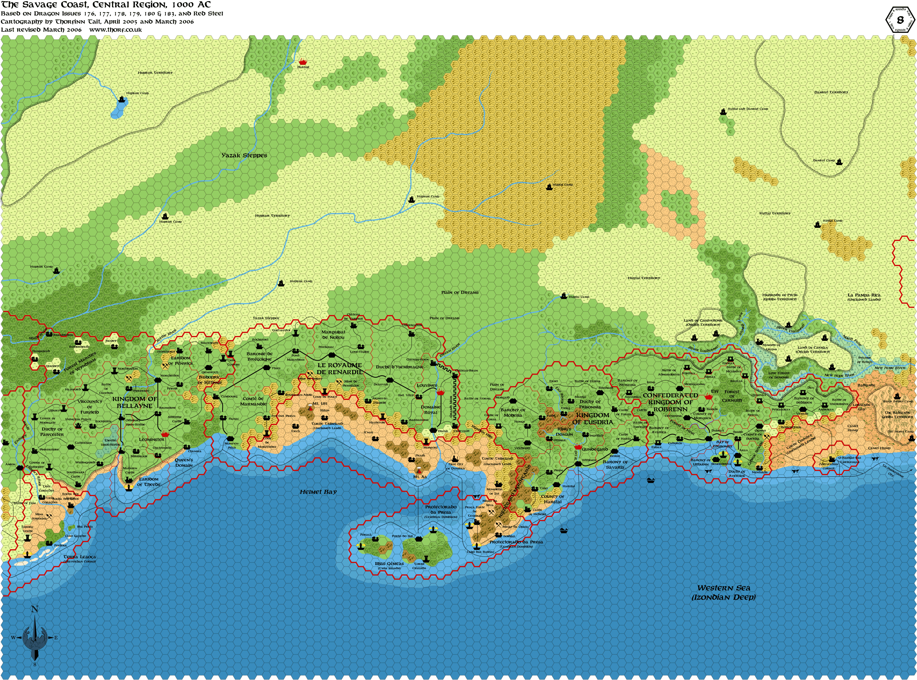
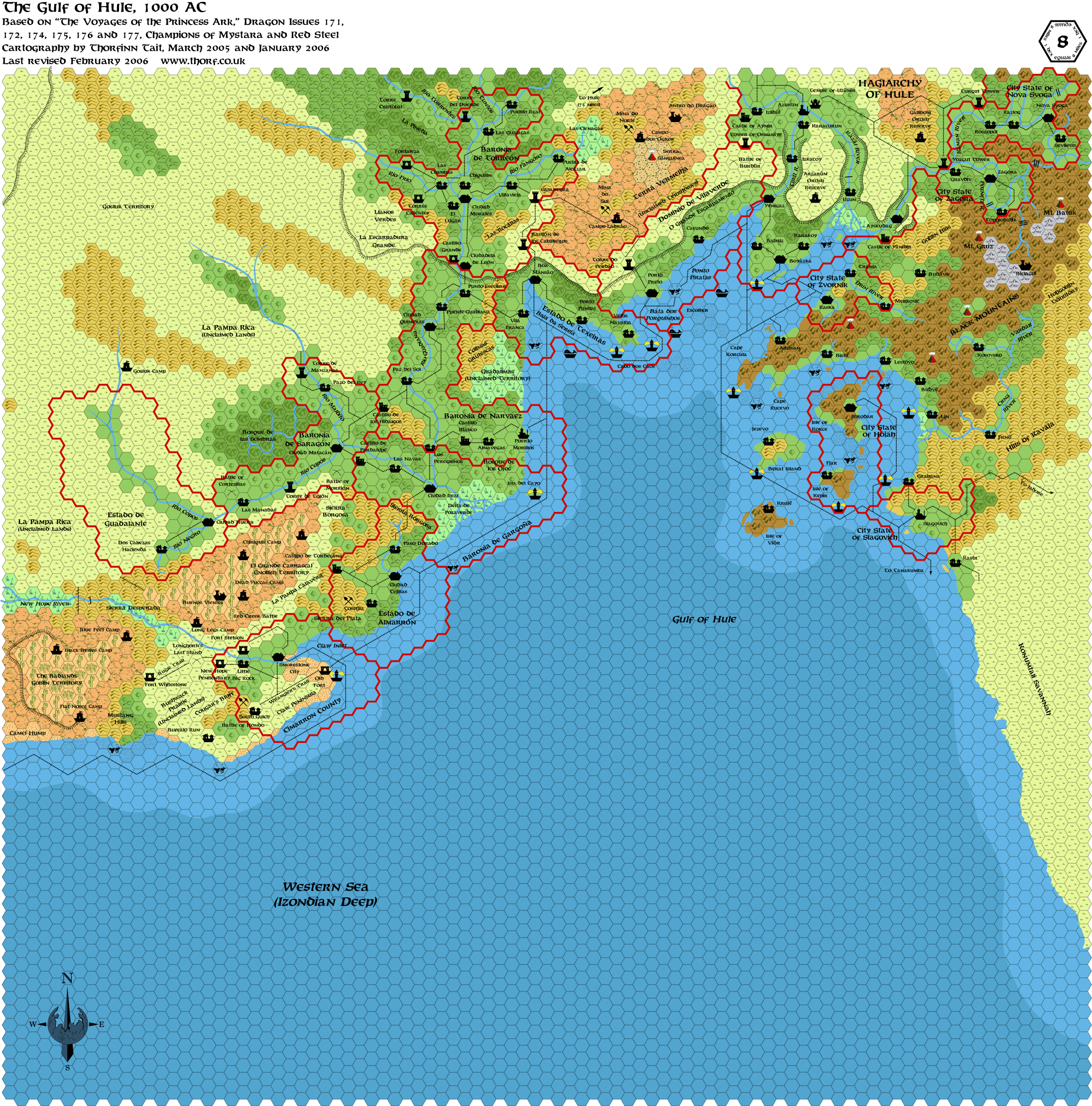
I just finished work on the middle section of the Savage Coast maps. I put off doing it for a while, but it ended up only taking one night.
Regarding these maps, I have taken the Red Steel additions as is for now. Obviously they could do with some development - the areas introduced on the Red Steel maps were painted with far too large a brush for my liking - but that can come later.
I also updated the Gulf of Hule map with the proper shallow and deep water, and added one of the missing trails (there are still two trails waiting to be added on the right hand side of the map).
- The Savage Coast, Central Region, 8 mi per hex PNG and PDF
- The Gulf of Hule, 8 mi per hex PNG and PDF
Please let me know if any of the links are broken. I'm not checking them myself because I don't want to waste bandwidth.  |
Mar 15, 2006 12:59:13
|
|
|
Thanks for doing this Thorf. I know you've heard it already, but I just wanted to throw in my 2 cents (pence? ) and tell you again. Keep up the good work!  |
Mar 15, 2006 13:26:52
|
|
|
Quote:
- The Savage Coast, Central Region, 8 mi per hex PNG and PDF
- The Gulf of Hule, 8 mi per hex PNG and PDF
|
It seems the thumbnails used for at least the first png file is not anymore up to date. Am I correct ?
If so I'll think about something to update automatically the thumbnails.
|
Mar 15, 2006 13:42:16
|
|
|
Join Date: Feb 2005
Location: Ontario, Canada
|
|
Quote:
|
Regarding these maps, I have taken the Red Steel additions as is for now. Obviously they could do with some development - the areas introduced on the Red Steel maps were painted with far too large a brush for my liking - but that can come later.
|
I see what you mean - still, this is great, Thorf! You have created the map that many of us have wanted for years.
Geoff
|
Mar 15, 2006 17:20:30
|
|
|
Quote:
|
Thorf,
The only issue I see with a PDF like that is printing. Most printers, including mine, won't print on paper as big as that image, and Acrobat Reader doesn't have any option that I can find for splitting it across multiple printer pages.
Gordon
|
The way I've found to print these at the same quality (as best as I can get it anyway) split over several pages is as follows (this does require Excel):
1) Open the .pdf file
2) Select the Snapshot Tool from the Tool bar at the top (Camera Icon)
3) Right click on the image, and then click the Select All option
4) Right click on the image again and select the Copy Selected Graphic option
5) Open Excel, and paste the image into a blank spreadsheet
6) Print
(This method of pasting into Excel works with all types of graphics file that I have tried so far.)
|
Mar 15, 2006 20:54:33
|
 |
|
|
Join Date: Mar 2004
Location: Ontario, Canada
|
|
Quote:
|
(This method of pasting into Excel works with all types of graphics file that I have tried so far.)
|
I didn't know about that. Does it print out at an 'original' size, such that the hexes from each map will be the same size? What I'm thinking about, is if it would be possible to print off several maps and place them together.
|
Mar 16, 2006 12:02:57
|
|
|
Copying from a .pdf file copies to the clip board at the relative zoom ratio from Acrbat Reader (ie if it's at 200% it will copy to the clipboard at 200% of the original's size), and then paste to another program at that relative ratio. So if you want to copy a number over at say 100% size, and then print them, providing the base hexes are the same size (which with Thorf's they appear to be) in the differing documents, then providing you don't adjust the dimensions of the image pasted into Excel, then they will print at the same size.
So providing you are patient and careful with the scissors and sticky tape (kind of like Blue Peter), you can put all of them together.
|
Mar 28, 2006 16:06:15
|
|
|
Quote:
|
Just FYI: Font embedding in PDF only works for viewing and printing (and editing if you have the full retail version of Acrobat) within the PDF environment. If you open the PDFs in Illustrator, all instances of the Baldur font will revert to Illustrator's default font, unless you have Baldur installed on your system.
|
And on that theme ...
Hey Thorf - what is Baldur-italic font? Is that your beta of the updated Baldur?
When I loaded the files up in Illustrator (an older version), although it recognised my Baldur font, it said I didn't have Baldur-italic installed. 
|
Mar 29, 2006 0:28:13
|
|
|
|
Join Date: Jan 2005
Location: Akita, Japan
|
|
Quote:
And on that theme ...
Hey Thorf - what is Baldur-italic font? Is that your beta of the updated Baldur?
When I loaded the files up in Illustrator (an older version), although it recognised my Baldur font, it said I didn't have Baldur-italic installed. |
Ah... Well, Illustrator wouldn't let me make Baldur italic - I think it needs a separate font file or definition to allow different styles and weights. So, I asked Patrick to make an italic version of the font as a separate file. It's not a redesign or a proper italic set, but rather just a simple tilt of the characters to the right. (In font terms, that makes it quite a primitive construction, but it seems to look right nonetheless.)
I'm not sure if it will ever be made available, though. If you're interested, the best I can suggest is that you e-mail Patrick and ask him if he would mind sending you a copy. Of course, it goes without saying that you buy Baldur first, right? (I know a lot of you have already anyway. )
|
Mar 29, 2006 14:59:51
|
|
|
Quote:
I'm not sure if it will ever be made available, though. If you're interested, the best I can suggest is that you e-mail Patrick and ask him if he would mind sending you a copy. Of course, it goes without saying that you buy Baldur first, right? (I know a lot of you have already anyway. ) |
Thanks Thorf.
I actually emailed Patrick a few days ago to ask about Baldur with the accents, and he said those of us who've already bought it will be able to download it for free from Myfonts.com when he's uploaded it, which will hopefully be soon.
I'll send him an email asking about the italic version right away!
|
Apr 01, 2006 17:34:26
|
|
|

Quote:
My new site is up and running!
Shughuy has been busy making a new interface for browsing my maps, and you can now find all the latest versions there.
Aside from the maps part, most of the links are still broken, but I'm going to be working on them as and when I find the time. Additionally, though I have fixed the index in the first page, the maps appearing on other pages in this thread will all be broken links until I can get round to updating the new URLs.
In the meantime, I have a little bonus test for those of you who are interested. I have uploaded the first five Gazetteer countries' maps in PDF format. These can be viewed in Acrobat Reader, and unlike the PNG files they will stay sharp however much you zoom in. Moreover, if you have Illustrator you can actually load them up and edit them there.
Please let me know what you think. If these are popular, I am considering uploading the whole series.
PDF Maps (Mar 2006)
Karameikos
Ylaruam
Glantri
Ierendi
Alfheim |
Thorf-
Long-time reader (been reading the Vaults since '97) & map-user here. Wanted to say that your PDFs do for Mystara what the Forgotten Realms Atlas did for Faerun. Great job!
(While you're at it, did you have any plans to make Thorf-editions of Geoff Gander's maps & Christian Constantine's maps? Gander did that huge Davania series, plus Wendar-Denagoth, plus the Heldannic Freeeholds. Constantine did Hule in 8m with detailed political subdivisions, plus that HUGE map of far-western Brun. Those guys' maps seem practically official now. Maybe time that they get the Thorf treatment?)
|
Apr 02, 2006 0:11:10
|
|
|
In response the Haldemar,
Thorf already has a map of Wendar up (with changing names  ), I've put up an 8mph of Denagoth based in part on the old Gander map (see the Denagothian Plateau Project thread, and soon to be updated), and I've also done a composite of his Davania maps. The last hasn't be posted yet as I discovered N-S vs E-W aspect issues - but that's a post for another day.
More areas will get the colormap treatment either by the great Thorf himself or a lesser light like me.
-OldDawg |
Apr 02, 2006 16:56:02
|
|
|
Great! Question for you all. What's the best program to use (is Illustrator required) & where do you get the hexes? Hope this isn't too OT for this topic.
Quote:
In response the Haldemar,
Thorf already has a map of Wendar up (with changing names ), I've put up an 8mph of Denagoth based in part on the old Gander map (see the Denagothian Plateau Project thread, and soon to be updated), and I've also done a composite of his Davania maps. The last hasn't be posted yet as I discovered N-S vs E-W aspect issues - but that's a post for another day.
More areas will get the colormap treatment either by the great Thorf himself or a lesser light like me.
-OldDawg |
|
Apr 03, 2006 18:01:23
|
 |
Culture20
UnCon Prizewinner
|
|
Join Date: Mar 2005
Location: USA
|
|
Quote:
|
Constantine did Hule in 8m with detailed political subdivisions, plus that HUGE map of far-western Brun. ...maps seem practically official now.
|
I'm not fond of Christian's maps for a couple reasons: his Hule directly contradicts canon sources, and his Western Brun fills Brun up so that DMs don't have enough lee-way. IMO, it's better to use them as inspiration for a geographical map that DMs can fill with whatever countries they want, even empty space.
Quote:
|
Great! Question for you all. What's the best program to use (is Illustrator required) & where do you get the hexes? Hope this isn't too OT for this topic.
|
I'm using Gnu Image Manipulation Program ( http://www.gimp.org) to slowly modify some of Adamantyr/Ironwolf's maps (slow because the amount of layers I'm using is crazy). Gimp is an open source, free (as in beer) program similar to photoshop, and just about any good digital editing program can do what it does. With enough layers and copy/paste tricks, you can flesh out a lot in no time. This method is nice in that it's free, and getting a new hex symbol is as easy as a screen-capture.
Thorf's method is distinctly different though. He's using Illustrator because it allows him to make images that look good zoomed at any level (as long as you're in Illustrator; but Illustrator can save bmps or tiffs of those huge zooms). It's also handy because I think he's using a snap-in grid for his hexes, so he can move his mouse much faster and not have to worry about precision. There are some free programs that begin to do what Illustrator used to do a long time ago, but Ilustrator's king at the moment.
|
Apr 03, 2006 19:51:08
|
|
|
Join Date: Feb 2005
Location: Ontario, Canada
|
|
Quote:
|
I've put up an 8mph of Denagoth based in part on the old Gander map [...] and I've also done a composite of his Davania maps. The last hasn't be posted yet as I discovered N-S vs E-W aspect issues - but that's a post for another day.
|
It's nice to be "immortalised" as a reference. First the Mercator Projection, now the Gander map!
Seriously, I'd be interested in knowing what the aspect issues are for the Davania maps. When I created them, they were designed to overlap slightly, and the model I used was the world map in the HW boxed set - it was the only one that showed vegetation zones and other features that I could use. Obviously there would be some distortions, but I would be interested in discussing this when you have the time.
Geoff
|
Apr 07, 2006 16:18:52
|
|
|
|
Join Date: Jan 2005
Location: Akita, Japan
|
|
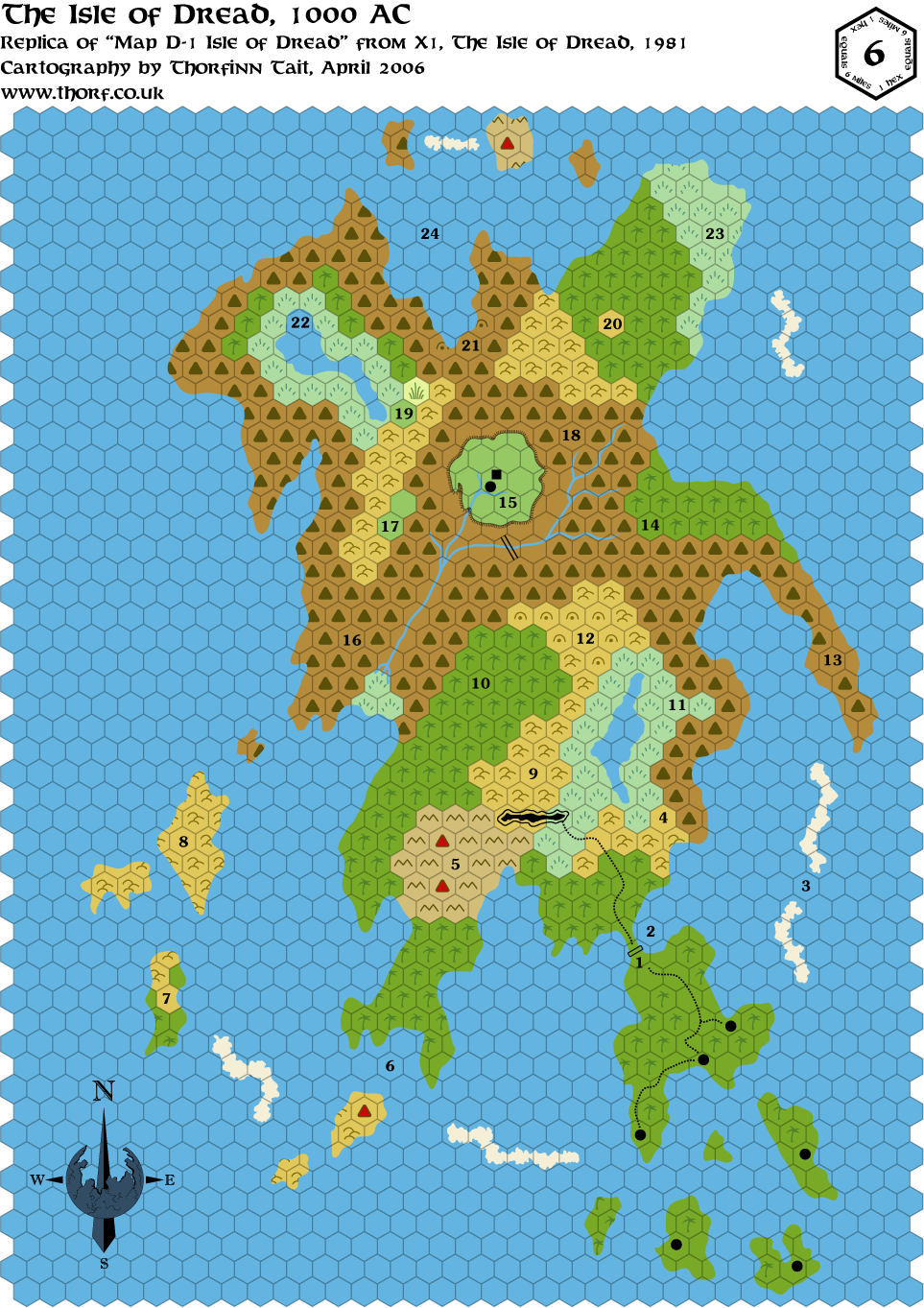
First the 1981 map:
Now the 1983 map:
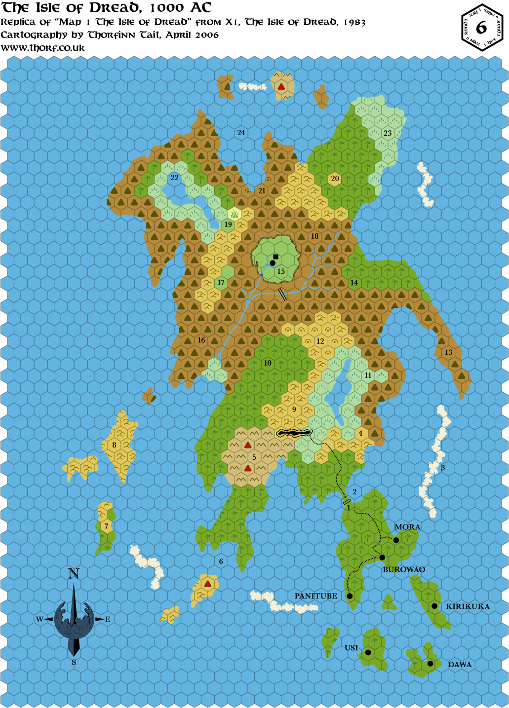
Very little changed - mainly just the font, village names being marked on the map, and the reefs in the east. |
Apr 07, 2006 16:20:26
|
|
|
|
Join Date: Jan 2005
Location: Akita, Japan
|
|
Lastly, here's my updated map. Note that I have changed the scale to 4 mi per hex so that the Isle fits with the other maps properly. (See this thread.)
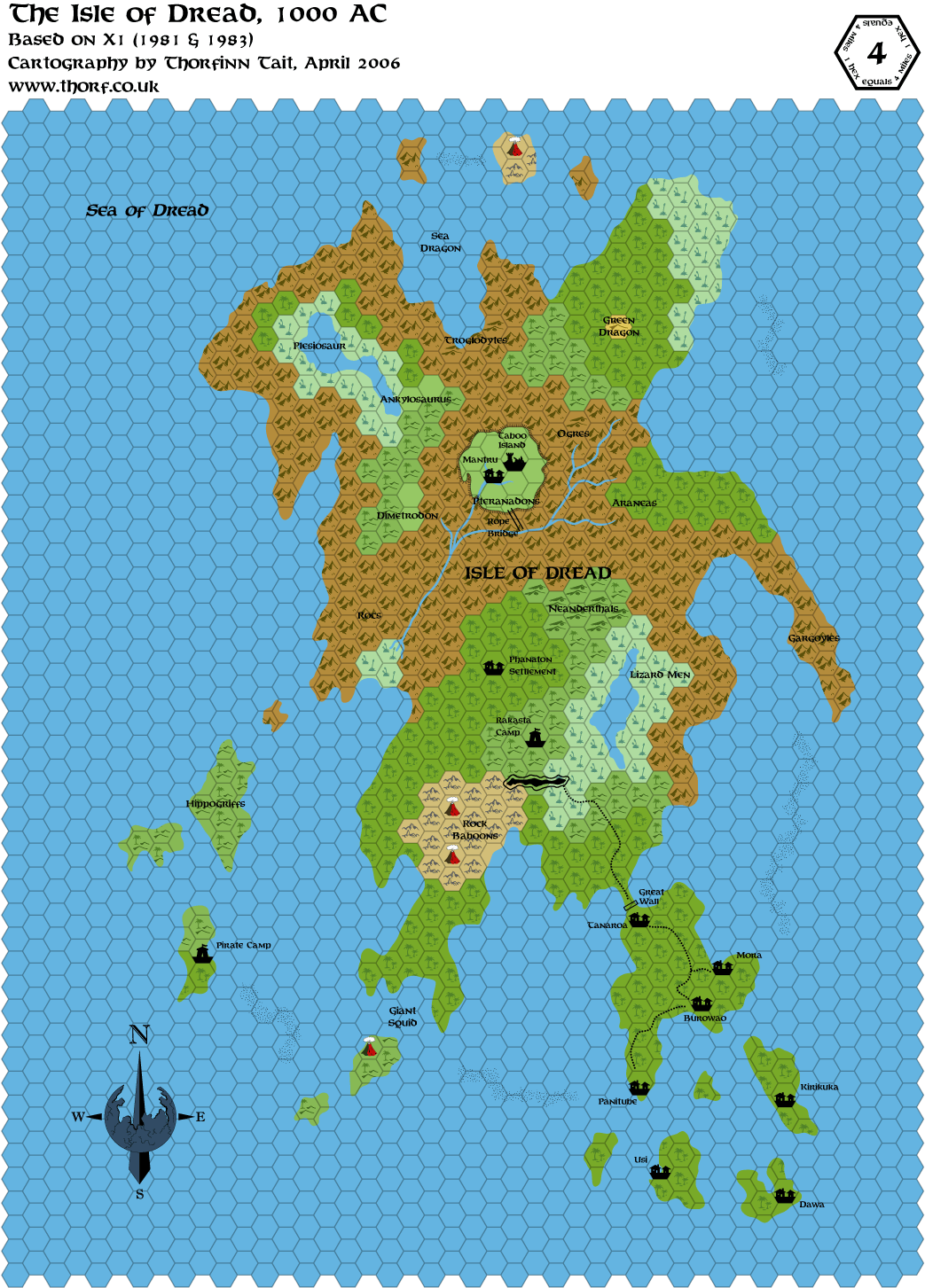
The fauna labels are a bit over the top, and will undoubtedly be trimmed out as more names get added. I'm considering using Dungeon 114's map as a source, but as I have mentioned elsewhere, I'm not too happy with all of the names on that map.
I also have to incorporate the detail map for the central plateau, but currently there is very little space to do so. If I remove the Taboo Island ruins symbol I could at least place the lake and the island, but it is perhaps better left to the detail map.
The major changes for now are the jungle hills and the rope bridge; I changed all hill hexes except for one into jungle hills - even the caves became jungle hill caves (which is a combination never used on official maps!). The bridge I moved so that now it actually does lead up to the plateau. I always thought it was really stupid that the bridge is nowhere near the edge of the plateau, even though it is supposedly one of the only access points.
Haldemar, sorry I haven't replied to you yet. You can get the hexes from me in Illustrator format, or download the PNG version here. Illustrator is necessary to do maps exactly like mine, but others (notably Mark, Geoff, Andrew and of course Thibault) seem to be making very nice maps without it just fine too.
More on this when I get the time. |
Apr 07, 2006 16:32:56
|
|
|
|
Join Date: Jan 2005
Location: Akita, Japan
|
|
You may have noticed that I only posted the replica maps with the old style art. This is due to a decision I made recently regarding the replica maps: if I keep them to their original symbol art as much as possible, it will make the fact that they are unaltered, un-corrected replicas much more obvious. Plus of course the maps will be closer to the originals, although I will not be turning them all black and white - I may release black and white versions at some point, but the main one will always be colour.
The next thing to work on in regards to the Isle of Dread is the 24 mi per hex reworking. I'm not sure when I'll get round to doing that, and Mark may well beat me to it (which would be nice ).
My mapping has been on the back burner for the last few weeks, mainly due to Final Fantasy XII, the end/beginning of my work year, and my other Mystara projects, but I'm hoping to be able to spend more time mapping again soon. |
Apr 12, 2006 12:47:44
|
|
|
Was looking for your legends on the web site, but the links don't appear to be working atm
|
Apr 12, 2006 12:47:44
|
|
|
|
Join Date: Jan 2005
Location: Akita, Japan
|
|
Quote:
|
Was looking for your legends on the web site, but the links don't appear to be working atm
|
I see the problem, I'll tell Shughuy. In the meantime, you can get to them by removing the "_00_" from the URL, or just by clicking on the links in the first post in this thread.
|
Apr 12, 2006 20:09:42
|
 |
|
|
Join Date: Dec 2005
Location: Robins AFB, GA
|
|
Wonders what stage Two is...
|
Apr 12, 2006 20:43:13
|
|
|
|
Join Date: Jan 2005
Location: Akita, Japan
|
|
Quote:
|
Wonders what stage Two is...
|
You might want to check the Projects page of my (still under construction) Mystara site for some hints.
I'm surprised no one has guessed yet.
|
Apr 12, 2006 22:50:35
|
 |
|
|
Join Date: Apr 2004
Location: Long Beach, CA
|
|
Don't recall if I've asked you yet or not, but is it an interactive map connecting to a database of Mystaran Lore?
|
Apr 12, 2006 23:36:50
|
|
|
|
Join Date: Jan 2005
Location: Akita, Japan
|
|
Quote:
|
Don't recall if I've asked you yet or not, but is it an interactive map connecting to a database of Mystaran Lore?
|
That's not quite what I have in mind, but it could certainly be done by restructuring my project.
My current concept is more of a PDF book, complete with professional-level editing, illustrations and so on. (At the moment I am considering using a selection of photos as illustrations.)
|
Apr 13, 2006 2:12:06
|
|
|
|
Join Date: Jan 2005
Location: Akita, Japan
|
|
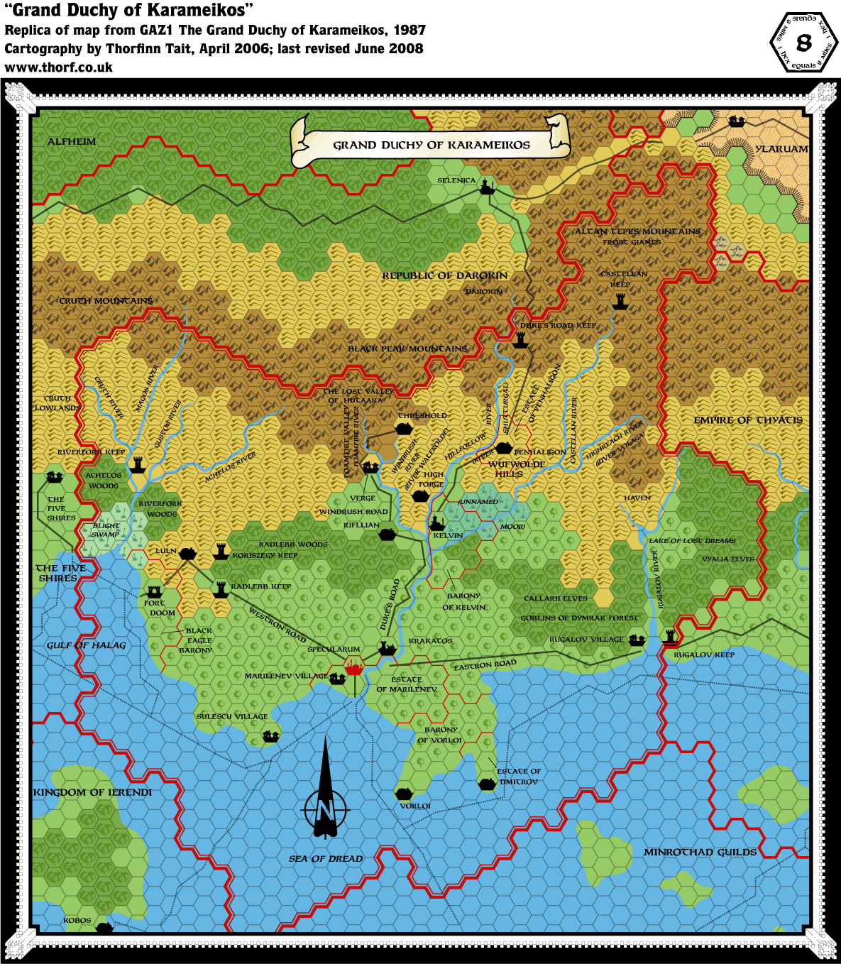
I'm trying to finalise my Known World maps, so that I can change the way I have them arranged in my files, and eventually republish them in a new style. In order to do this, I'm working through recreating all the sources for each map. It's not a huge task, since I already have a base map to work backwards from.
Here is the first of these replicas, the Karameikos map from GAZ1. This map is pretty accurate, and of course it is the base for a lot of the other maps in the series. A few things were changed from this map in later versions, though: the coastlines of the islands, one hex on the far northeastern border, some of the rivers were shortened, all the rivers were later redrawn with subtly different paths, the roads and trade routes were completely redrawn (thankfully) and some new ones added, and so on.
 |
Apr 13, 2006 17:55:00
|
 |
|
|
Join Date: Mar 2006
Location: Empire of Zuyevo, Brun (Texas)
|
|
Looks good. I loved all your other maps but my only complaint for the 8 mile ones was that you couldnt see whats on the other side of the border! I printed your Karamekios map and when my son looked at it the first thing he said was "whats on the other side of the mountians?" |
Apr 13, 2006 20:18:27
|
|
|
|
Join Date: Jan 2005
Location: Akita, Japan
|
|
I'm aiming to republish my updated maps in a similar format as soon as I can, but first I have to finalise them, to minimise the amount of updating I'll end up having to do to multiple sources. For example, right now in order to fix a mistake I just need to load up that country and fix it once, but once I have that country on multiple maps, I will have to fix each one separately.
Hence the move "back to the beginning" with recreating the original Gazetteer maps and other primary sources. It's going to take a while, but I think the end result will be worth it.
|
|
|