Thorf's Secret Project: Stage One
A recreation of the Mystara Message Board thread that started the Atlas of Mystara project, with restored links and images.

17 February 2005, 04:51 AM
|
 |
Member
|
|
Join Date: Jun 2003
Location: Christiansburg, VA. North of Specularum.
|
|
Quote:
|
Originally Posted by Thorf
Very
nice maps, Ray! Did you do the hex art yourself? They look extremely
similar to the official hexes. It's great to see such high quality
maps.  |
The hexs came with HexMapper but I used Quickview to do the coastlines and the borders.
BTW, do you have your hexs available for download? If they are in .bmp format, they could probably be used with HexMapper too.
--Ray.
|
17 February 2005, 06:09 AM
|
 |
Member
|
|
Join Date: Apr 2004
Location: Denmark
|
|
Quote:
|
Originally Posted by Thorf
...with forested hills throughout!
|
Wow... that's a lot of trees...
Quote:
|
PS - I'm starting to think that forested hexes would look better with
just the normal "plains" colour for their background. Do you think it's
enough to just have the heavy forests shaded? I'm still open to
opinions and suggestions. |
I am confused  Seems to me the forested hexes have "plains" colour as their background? And heavy forest hexes are a darker shade?
:-) Jesper
|
17 February 2005, 09:20 AM
|
 |
Member
|
|
Join Date: Mar 2004
Location: Ontario, Canada
|
|
Quote:
| PS - I'm starting to think that forested hexes would look better with just the normal "plains" colour for their background. Do you think it's enough to just have the heavy forests shaded? I'm still open to opinions and suggestions. |
I wonder what it would look like if the "hills" in the forested hills
hex were a brown colour; kind of a combination of the forested hex and
hills hex. I really can't picture it on a map in my mind, but maybe you
could test it to see if it works or not (I have a feeling it wouldn't,
but you never know till you see it).
Oh ya, I'd like to see that!
Quote:
|
...with forested hills throughout! To be honest, faithful as this is to
the Gazetteer's text, I think it's going a bit too far. |
Visually perhaps, but I've always seen this to be the way in which
Karameikos was described. On the map it appears to be one huge,
unending forest, but it actually only represents that these hexes are dominated
by woods. There are still many open areas and grassy fields. Perhaps
you could place a few "open" hexes here and there to show areas where
there is more open space than forest (i.e. areas where the woods are in
small isolated patches).
Bottom line though is I like your new vision of the "dark-forested
Karameikos wherein the lycanthrope and undead find their shelter".
|
17 February 2005, 10:10 AM
|
|
Member
|
|
Join Date: Apr 2004
Location: Denmark
|
|
 Roads and trails
I have been admirring your beautiful maps for a few days now, and I did find one tiny thing that I would change if I were you.
The hex grid is on top of everything else. That is fine because most
things such as trees or mountains do not cross into another hex. But
roads and trails do. And I must say that looking at the maps from 40 cm
away I think it looks like lots of little "holes" or gaps in the roads
and trails.
If I had my way, roads and trails should go on top of the grey hex grid. not the other way around.
Other than that: like I said - beautiful! 
:-) Jesper
|
17 February 2005, 12:56 PM
|
 |
Member
|
|
Join Date: Jan 2005
Location: Akita, Japan
|
|
 Second try at a reply due to IE crash...
Quote:
|
Originally Posted by maddog
BTW, do you have your hexs available for download? If they are in .bmp format, they could probably be used with HexMapper too.
|
Yep, they're in the first post of this thread, in PNG format. You can
easily change it to BMP format using any image editing program.
I have to go to work in about two minutes, so I'll reply to the rest later. For now, here's a map or two to tide you over!
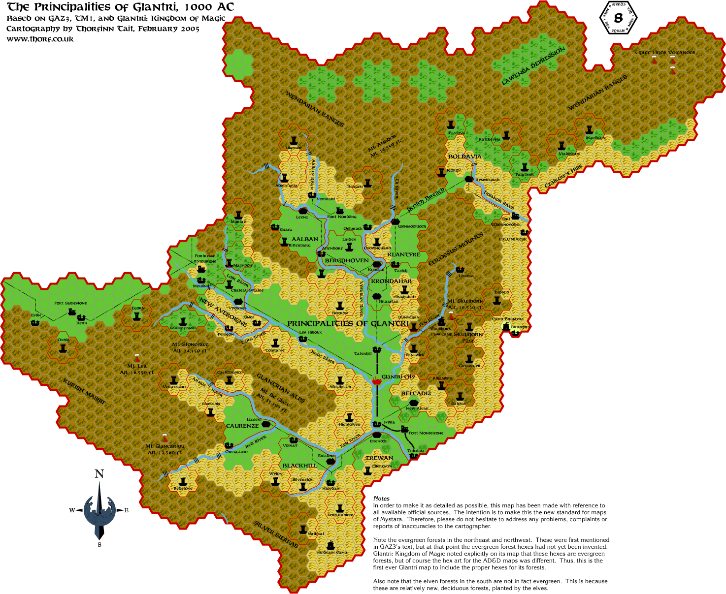
This is my revised Glantri map, using evergreen hexes for the appropriate forests, as described in the Gazetteer.
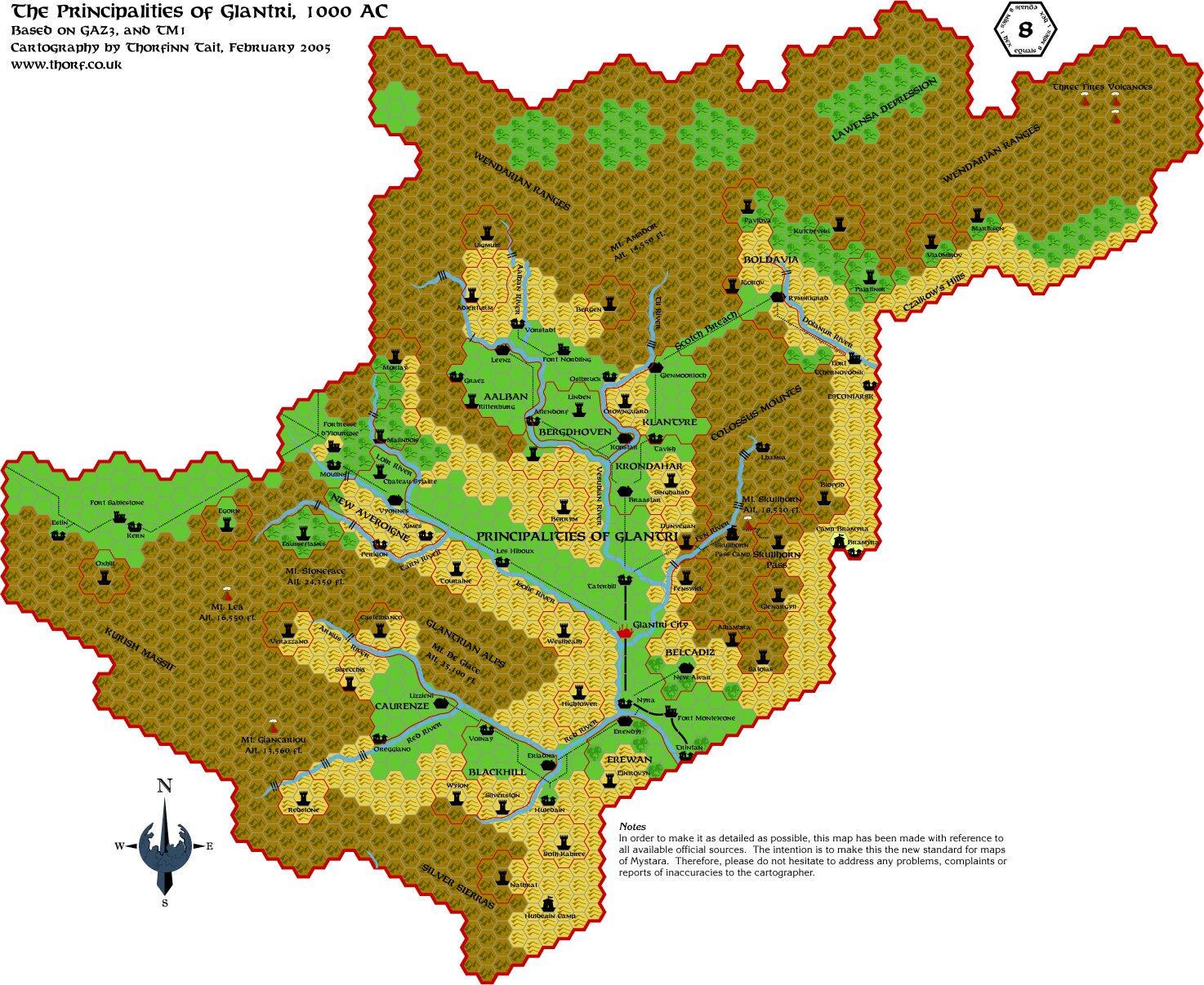
For the traditionalists among you, I also have a map using all deciduous forest hexes:
PS - Spellweaver, look at the forested dominions to see what I mean
about the shading. I could change the colour underneath the settlements
to match the forested hexes, but I'd rather just normalise the forested
hills again. Also, forested hills and heavy forests are indeed the same
shade right now. I did say it was very subtle! 
PPS - (Gonna be late for work!! ARGH!!) Also I agree with you Jesper
about the roads and trails. I had noticed it too while making the maps,
but I never got round to fixing it. It's actually not just a trivial
fix - it might require me to add in another layer, or at least do a
layer reshuffle. Anyway I'll start working on it, and post new versions
of all the maps when I get it done.
Last edited by Thorf : Today at 06:20 AM.
Reason: Corrected info about all-deciduous version
|
17 February 2005, 01:19 PM
|
 |
Member
|
|
Join Date: Jan 2005
Location: Michigan
|
|
 RE: Thorf's Secret Project
I think what you're doing thorf is a great idea, and it is a long time overdue.
If the Mystara setting were ever redone I would like to see the maps redone as well.
I hope you are going to redo ALL the Gazetter maps, as the land of
Mystara is not just The Grand Duchy of Karameikos, but all the
surrounding lands as well.
I hope you keep up the good work that you are doing, it is VERY much appreciated, and many of us will be looking forward to it.
|
17 February 2005, 08:00 PM
|
 |
Member
|
|
Join Date: Apr 2004
Location: Andover, United Kingdom
|
|
Totally Awesome! - I had to say it.
Thanks also for the new version of Karameikos, that fits a lot better
with my understanding from the text, and I think it also makes better
sense geographically - there would need to be a reason for the trees to
stop so far form the mountains and there doesn't seem to be one - this
way the forest goes all the way to the natural boundary
__________________
"If it looks like a duck and quacks like a duck it might just be a crow."
|
18 February 2005, 01:04 AM
|
|
Member
|
|
Join Date: Jan 2005
Location: Akita, Japan
|
|
They just keep getting better and better...
Quote:
|
Originally Posted by black dragon karameikos
I think what you're doing thorf is a great idea, and it is a long time overdue.
If the Mystara setting were ever redone I would like to see the maps redone as well.
|
Yep, and that's why I'm redoing them. 
With this techonology at our fingertips, and the time to devote to the
project, we can actually make maps that surpass the quality of the
originals - and the accuracy of the originals too.
The only disadvantage really with these maps is that it's not so easy
to print them out. But in my case, I can probably get a pretty nice big
printout next time I visit my parents. If I can get the colour settings
right, it really will mean that my maps are equal or better than the
official ones in all ways.
Quote:
|
I hope you are going to redo ALL the Gazetter maps, as the land of
Mystara is not just The Grand Duchy of Karameikos, but all the
surrounding lands as well. |
Yes I agree wholeheartedly there. In fact, I already have almost all
the Gazetteer maps done. But I'm only posting one a day, because I'm
going to run out of things to post pretty soon. Anyway it's nice to hear feedback on each map as it appears, and hopefully correct any mistakes that are found.
Quote:
|
I hope you keep up the good work that you are doing, it is VERY much
appreciated, and many of us will be looking forward to it.
|
Thanks very much!
On a different note: Katana One has been helping me with some handy
Illustrator advice and tips, and hopefully I'll be able to make the
jump from 8.0 up to Illustrator CS pretty soon - hopefully by next
week. Doing so opens up a whole lot of new possibilities, including one
feature that was on my wish list from the start - a transparent hex
grid. 
I'll keep you informed, and when I do upgrade, I'll do a pass of all
the currently released maps using the new features, and upload them
here. It will likely take some time, though.
One last thing before I go to bed: I've had some life changing
decisions to make this week, and it's going to come to a head at the
weekend, so don't be too surprised if my updates stop for a few days. I
probably won't be able to resist coming and posting a map anyway, but
apologies in advance if I don't manage. 
|
18 February 2005, 01:40 AM
|
 |
Member
|
|
Join Date: Mar 2004
Location: Stockholm, Sweden. For a while.
|
|
This thread is SO much fun! Thank you.
And good luck with all the life-changing decisions!
|
18 February 2005, 04:40 AM
|
|
Member
|
|
Join Date: Jan 2005
Location: Akita, Japan
|
|
 3 and a half hours later...
...and I'm just now heading for bed. Oops!
But I have a lot to show for it. With the help of Katana One, I have
finally been able to update my files to the latest version of
Illustrator. If you don't think that sounds exciting, go and check out
the Karameikos map in page one of this thread - the one nearest the top
of the page. Alternatively you can click here.
I just spent over an hour converting the map just so I could post an
example of what the maps will be like from now on, thanks to Katana
One's help.

|
18 February 2005, 11:11 AM
|
|
Member
|
|
Join Date: Dec 2003
Location: Jacksonville, FL
|
|
Glad I could help!
I just wish I had time to help out even more!
__________________
Obligatory non sequitur goes here.
|
18 February 2005, 11:58 AM
|
|
Member
|
|
Join Date: Jan 2005
Location: Akita, Japan
|
|
 Tough day
After
my late night, my morning job of teaching 3 year olds at a local
kindergarten was somewhat uncomfortable, but fun in the end. Hehe.
Anyway, now I'm off to teach 18 year olds at a local high school. You
might say I'm an odd job man here. But before I go, here's today's map!
Of course I didn't have time to update it (or any others) yet, so it's
still in the old format. I'll give you all a heads up whenever I upload
an updated map so you can keep with the most current versions. This map
and others with lots of sea probably benefit the most from being
upgraded, because the solid hex grid looks really ugly on the ocean.
|
19 February 2005, 04:23 PM
|
|
Member
|
|
Join Date: Jan 2005
Location: Akita, Japan
|
|
Today's maps
I
was hoping to have time to remake these before posting, because they're
pretty small. But other things came up, so I'm giving them to you
as-is. I'll hopefully get them all converted over to the new style by
the end of next week.
Today I'm giving you Alfheim...
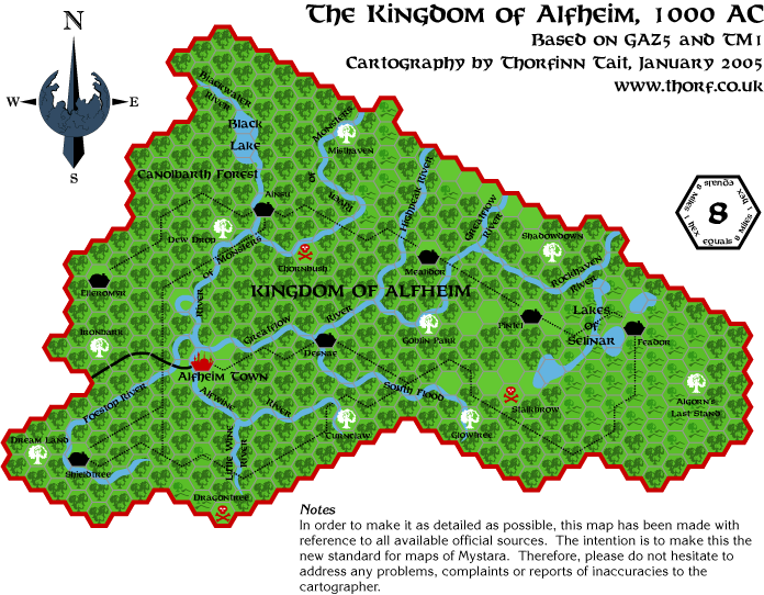
...and its "evil twin", Aengmor.
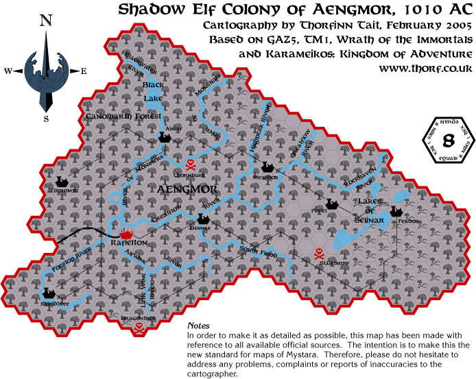
For now, the Aengmor map is really nothing but an Aflheim map with
forest hexes switched for dead forest hexes. In the future I hope to
make a few more additions to it, so if you have any suggestions, I'd
love to hear from you.
|
20 February 2005, 05:27 AM
|
|
Member
|
|
Join Date: Mar 2004
Location: Stockholm, Sweden. For a while.
|
|
Quote:
|
Originally Posted by Thorf
For
now, the Aengmor map is really nothing but an Aflheim map with forest
hexes switched for dead forest hexes. In the future I hope to make a
few more additions to it, so if you have any suggestions, I'd love to
hear from you. |
At the time, I had some ideas regarding an "evil" wood-imp kingdom
around the former Dreamlands. This is non-canon, of course - so I don't
know if you'd wish to use it at this point. Anyways, the link is:
http://boards1.wizards.com/showthread.php?t=198356 (Archived at Vaults of Pandius)
EDIT: Oh, and you'd might wish to take a look at PC1 regarding the
Alfheim map. It has some unique features for the area - such as Hsiao
complexes etc.
Last edited by Lost Woodrake : 02-20-05 at 05:33 AM.
|
20 February 2005, 02:32 PM
|
|
Member
|
|
Join Date: Jan 2005
Location: Akita, Japan
|
|
 Nice idea
And
thanks for the tip on PC1. The problem with the map in that book is
that the scale is extremely small - 1 mile per hex. It would of course
be possible to mark the Hsiao complexes on an 8 mile per hex map, but
it would turn that whole region of Alfheim into nothing but Hsiao
complexes. Also, since there are only three known Hsiao complexes it
might suggest that that's the only place they are, which is obviously
not true.
What I'll probably do is just remake the map from PC1 eventually.
In any case, continuing with the maps, today is Rockhome.
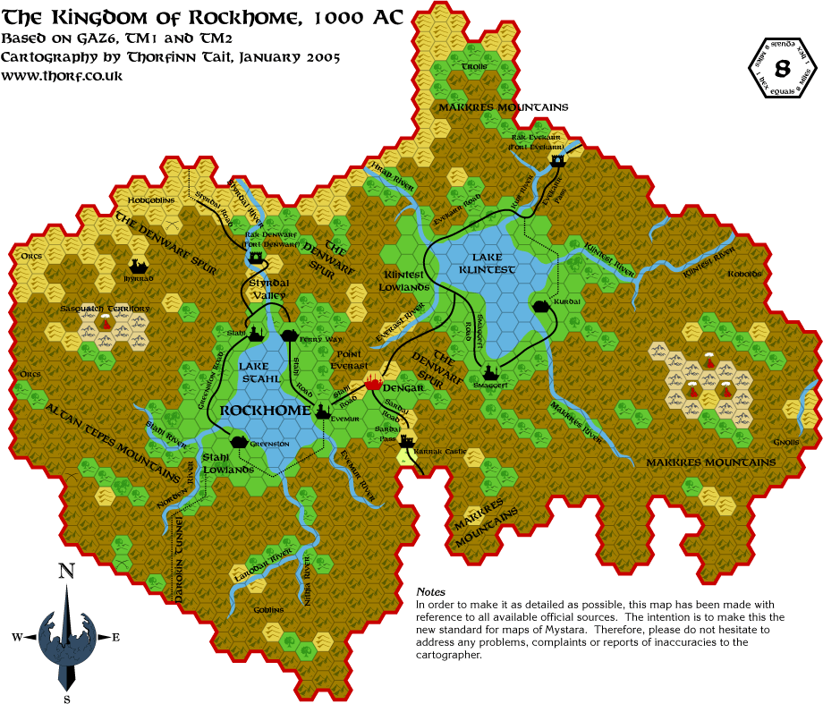
I'm not sure what to do about Rockhome's trees. According to the
Gazetteer, most of them should be evergreen hexes, but the trees on
Darokin border are a little bit questionable. Eventually I think I'll
probably end up making those trees in Darokin evergreens as well.
Edit: I just changed the forests to evergreen. You can see this updated version below:

Last edited by Thorf : Today at 06:27 AM.
Reason: Updated the map; edited the edit
|
20 February 2005, 05:49 PM
|
|
Member
|
|
Join Date: Mar 2004
Location: Stockholm, Sweden. For a while.
|
|
One more thing regarding Aengmor: Did all the lakes and rivers of Alfheim survive the change?
|
20 February 2005, 08:44 PM
|
|
Member
|
|
Join Date: Apr 2004
Location: Andover, United Kingdom
|
|
Nice work so far
One thing on the Rockhome map - you have preserved the split river
(labelled Klintest River) leading both into Lake Klintest and into the
Northern Reaches. Whilst I am happy with this, the branch of the river
flowing East to the border should not be the Klintest River (I can't
remember the real name) - it is not flowing into the lake but into the
sea. The little arm pointing South is not a tributary - it is the
source of both rivers, so the river to the border has to be a different
waterway.
As for your tree problem - in temperate lands there is usually an
altitude line below which the forests are deciduous and above which
conifer. This would enable all the Rockhome woods to be evergreen and
the Darokin woods deciduous - Rockhome merely claim the mountains down
to the treeline change...
|
20 February 2005, 09:51 PM
|
|
Member
|
|
Join Date: Jan 2005
Location: Akita, Japan
|
|
Updates
Quote:
|
Originally Posted by Lost Woodrake
One more thing regarding Aengmor: Did all the lakes and rivers of Alfheim survive the change?
|
That's a good question. I don't know the answer - it depends on whether
you think that the elven magic which created Alfheim's nightly rains is
still in effect or not. I do seem to remember GAZ5 mentioning something
about the elves performing some kind of "upkeep" to keep the magic
working...
On the other hand, Aengmor would look pretty boring without them.
By the way, I have now updated and posted the following maps:
Karameikos, Ylaruam, Alfheim, Aengmor, Rockhome. The rest should follow
before too long. Unfortunately all this updating has brought my
progress on making new maps to a halt. This week looks like it'll be
pretty busy, but then from next week I'm going to have a lot more free
time for a month or two, so hopefully I can get back on track.
|
20 February 2005, 10:03 PM
|
|
Member
|
|
Join Date: Mar 2004
Location: Stockholm, Sweden. For a while.
|
|
Quote:
|
Originally Posted by Thorf
On the other hand, Aengmor would look pretty boring without them. |
Unless, of course, the dried-up rivers and lakes created ravines, wadis, craters etc.
Just a thought.
|
20 February 2005, 10:12 PM
|
|
Member
|
|
Join Date: Jan 2005
Location: Akita, Japan
|
|
Problems
Quote:
|
Originally Posted by Kheldren
One
thing on the Rockhome map - you have preserved the split river
(labelled Klintest River) leading both into Lake Klintest and into the
Northern Reaches. Whilst I am happy with this, the branch of the river
flowing East to the border should not be the Klintest River (I can't
remember the real name) - it is not flowing into the lake but into the
sea. The little arm pointing South is not a tributary - it is the
source of both rivers, so the river to the border has to be a different
waterway.
|
You've hit on a very thorny problem here, I'm afraid. The rivers in
both Rockhome and the adjacent Northern Reaches are somewhat
problematic.
To break things down: - Page 6 of GAZ6 implies that the Klintest River runs into Lake Klintest.
- Page 46 explicitly states that the river "forms in Lake Klintest and flows east into a gorge in the Makkres Mountains."
- Page
46 also states that the Kur River forms in Lake Klintest and flows east
to the Sea of Dawn. The small source on the Kur River must therefore be
a tributary.
- The Kur River becomes/is known as the Vestfjord River in Vestland.
- Page
8 of GAZ7 describes the Vestfjord River and another river, the
Landersfjord, as "cutting through the Makkres Range to the west,
reaching far into the Great Lakes region of Rockhome."
- The
Landersfjord River is described as being easily navigable to the town
of Landersfjord. However, on all the maps the Landersfjord River is
southeast of Landersfjord, and unconnected.
- The river that does
flow past Landersfjord is attached to the River Klintest, and has its
estuary in Marsfjord. And indeed it is labelled as the "Klintest River"
on GAZ7's map and TM2.
It looks to me as if there was a lot of confusion around this area. All
the rivers can't flow into Lake Klintest, as page 6 of GAZ6 suggests -
there has to be a runoff to somewhere. And it makes sense to me for the
Klintest River to be the major runoff. Unfortunately, both the rivers
described as flowing out of Lake Klintest (page 46 of GAZ6) have
sources which make it look very much as if they flow into the river.
The other river is the Kur, by the way, which is not actually labelled
on the official maps.
The whole issue of Rockhome's rivers is a complete mess. For now, I
have basically just gone with the official maps, aided a little by the
Gazetteer texts.
Quote:
|
As for your tree problem - in temperate lands there is usually an
altitude line below which the forests are deciduous and above which
conifer. This would enable all the Rockhome woods to be evergreen and
the Darokin woods deciduous - Rockhome merely claim the mountains down
to the treeline change... |
The problem is that the connected Darokin forested hills are also in
the mountains - in the Orclands. Hence I am considering marking them as
evergreen too.
|
20 February 2005, 10:13 PM
|
|
Member
|
|
Join Date: Jan 2005
Location: Akita, Japan
|
|
 Cool!
Cool!
Quote:
|
Originally Posted by Lost Woodrake
Unless, of course, the dried-up rivers and lakes created ravines, wadis, craters etc.
Just a thought.
|
If that's the case, I'd have an excuse to make a new "dry river bed" mapping symbol. Still, I don't think all of them will have dried up.
|
20 February 2005, 10:56 PM
|
|
Member
|
|
Join Date: Feb 2005
Location: Ontario, Canada
|
|
Quote:
|
Originally Posted by Thorf
If that's the case, I'd have an excuse to make a new "dry river bed" mapping symbol. Still, I don't think all of them will have dried up. |
Well, if you do decide to have some of the rivers end up being dry, you
can find the symbols for dry rivers on the Sind map - but you probably
already knew that, since you've obviously been extremely thorough in
your work! I've said it before, but I have to say it again - this is
absolutely brilliant, Thorf!!
Incidentally, could you add me to the list of people who would like the
tile set you used? I think it's time to update the maps I've done to
the new standard... :-D
Geoff
|
21 February 2005, 03:13 AM
|
|
Member
|
|
Join Date: Jan 2005
Location: Akita, Japan
|
|
Thanks!
Quote:
|
Originally Posted by Seer of Yhog
Well,
if you do decide to have some of the rivers end up being dry, you can
find the symbols for dry rivers on the Sind map - but you probably
already knew that, since you've obviously been extremely thorough in
your work!
|
Heh, I was waiting for someone to say this.
Quote:
|
I've said it before, but I have to say it again - this is absolutely
brilliant, Thorf!! Incidentally, could you add me to the list of people
who would like the tile set you used? I think it's time to update the
maps I've done to the new standard... :-D |
I'm really glad you like the maps enough to want to use them yourself.
By the way, I'm working on a page that will explain the files and how
to use them. When it's done, I'm going to post it on my site, and I'll
be happy to send the URL to anyone who's interested. Hopefully it'll
help clear up some confusion between the versions and how to use the
files.
Edit: I just completed the short explanation page. Anyone who's
interested, please feel free to ask and I'll point you in the right
direction! The page includes both the 8.0 and the CS versions of the
files.
Last edited by Thorf : 02-21-05 at 04:06 AM.
Reason: Added an update on mapping files
|
21 February 2005, 09:11 AM
|
|
Member
|
|
Join Date: Jan 2005
Location: Akita, Japan
|
|
Monday's map
Today's
map is somewhat special. The Northern Reaches maps presented up until
now have always been somewhat empty, but the fact is that the data to
expand them fully was always there in GAZ7. I have taken that data and
the small maps in GAZ7 and applied it to the colour poster map, thus
creating the first "complete" map of the Northern Reaches.
As always, you can get an all deciduous version of this map on request.
Last edited by Thorf : Today at 06:32 AM.
Reason: Corrected info about all-deciduous version
|
21 February 2005, 02:25 PM
|
|
Member
|
|
Join Date: Mar 2004
Location: Ontario, Canada
|
|

Where was this map a few months ago; my players are presently leaving the Northern Reaches.
That aside, this map looks fantastic! I think it's my favorite so far!
Maybe that's partly because my copy of Gaz 7 doesn't have the map with
it. I had to use the (incomplete) ones from the Rules Cyclopedia and
the small black and white ones from the gaz's book.
Btw, I prefer the evergreens. Afterall, it just represents the more
dominate type of trees, not that there are no deciduous trees present.
|
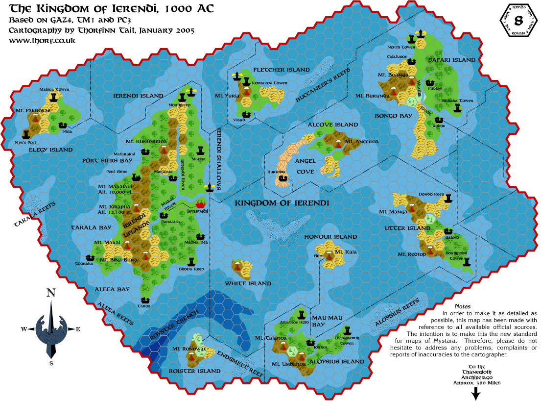
22 February 2005, 04:04 AM
|
|
Member
|
|
Join Date: Jan 2005
Location: Akita, Japan
|
|
I agree...
I like the evergreens too. They look especially nice on this map, I think.
FYI: I just updated the maps for Glantri and Ierendi, so now all the
maps posted so far except for the Northern Reaches are in the new
format.
|
22 February 2005, 07:04 AM
|
|
Member
|
|
Join Date: Apr 2004
Location: Denmark
|
|
Love
the evergreens on the Northern Reaches map - it looks much more natural
than on the other maps, dunno why. Perhaps it is because I am from
Denmark, so this fits the map in my mind of how a Scandinavian realm
should look
One thing though:
I would love to see the Sodervirk wall south of Whiteheart depicted on
the map. Not sure if there is a map symbol for such a wall, but if not
- then that's one more challenge for you!
Keep these great maps coming!
:-) Jesper
|
22 February 2005, 07:08 AM
|
|
Member
|
|
Join Date: Apr 2004
Location: Denmark
|
|
Bramyra?
Quote:
|
Originally Posted by Thorf
FYI:
I just updated the maps for Glantri and Ierendi, so now all the maps
posted so far except for the Northern Reaches are in the new format.
|
Just had a look at the Glantri map. What's up with the different colours of the Bramyra and Camp Bramyra hexes?
Just thought I'd mention it...
:-) Jesper
|
22 February 2005, 07:30 AM
|
|
Member
|
|
Join Date: Mar 2004
Location: Ontario, Canada
|
|
Quote:
|
Originally Posted by Spellweaver
Just had a look at the Glantri map. What's up with the different colours of the Bramyra and Camp Bramyra hexes?
|
Those hexes are grasslands, just like the majority of the Khanates.
This would be a situation were Glantri has moved the border beyond the
"natural border" of the mountains and into "Ethengar territory".
Glantri holds this area only because of the continued presence of
Bramyra and Camp Bramyra. I'd think hostilities here could be very
frequent once in while when a group of Ethengars decide they want that
land back. Good place for a Ethengar mini-campaign. 
Quote:
|
I would love to see the Sodervirk wall south of Whiteheart depicted on
the map. Not sure if there is a map symbol for such a wall, but if not
- then that's one more challenge for you! |
I'll second that motion. All in favour, say "I"!
|
22 February 2005, 10:10 AM
|
 |
Member
|
|
Join Date: Apr 2004
Location: Long Beach, CA
|
|
Wow- Count me as one who prefers the Evergreen Northern Reaches map to the Deciduous.
Nice to see you include the domain names and boundaries- I've got a NR
map mostly finished that does the same, and includes some other
features (the Stones of Sky and Ruthin Monastery from X13- as well as,
eventually, the now-vacant dominions that are depicted in that module-
Estin, etc.)
One thing about the domains and their sizes, though, that I noticed
recently (while trying to do some Economics Spreadsheet workups with
them). The boundaries on the map don't always match up with the square
mileage given in the Gaz. Some of the domains should have more area,
some less. More work for us, I guess.
|
|
|