Thorf's Secret Project: Stage One
A recreation of the Mystara Message Board thread that started the Atlas of Mystara project, with restored links and images.

14 March 2005, 03:36 PM
|
 |
Member
|
|
Join Date: Jan 2005
Location: Akita, Japan
|
|
 Monday's Maps
Today's maps are a bit of a cheat, but I'm still at my fiancee's mother's house until this evening, so
they'll have to do. 
When I get home I'll finish putting this map and the City States maps together. I also have just
one small part to do on the smooth contours version of Ylaruam, so I'll be posting it later too. That
leaves just the Atruaghin Plateau to go. Of course, I'm still researching my revised version of that, so I'm
not sure that smoothing out the plateau is a priority right now. (Though it's relatively easy to do.)
The good news is that most of my work has stopped, or stops this week, for the spring holidays. So
hopefully I'm going to have a lot more time to work on maps and stuff over the next month. 
Last edited by Thorf : 03-14-05 at 03:57 PM.
Reason: Reformatted text and added some notes.
|
14 March 2005, 10:08 PM
|
|
Member
|
|
Join Date: Jan 2005
Location: Akita, Japan
|
|
 As promised...
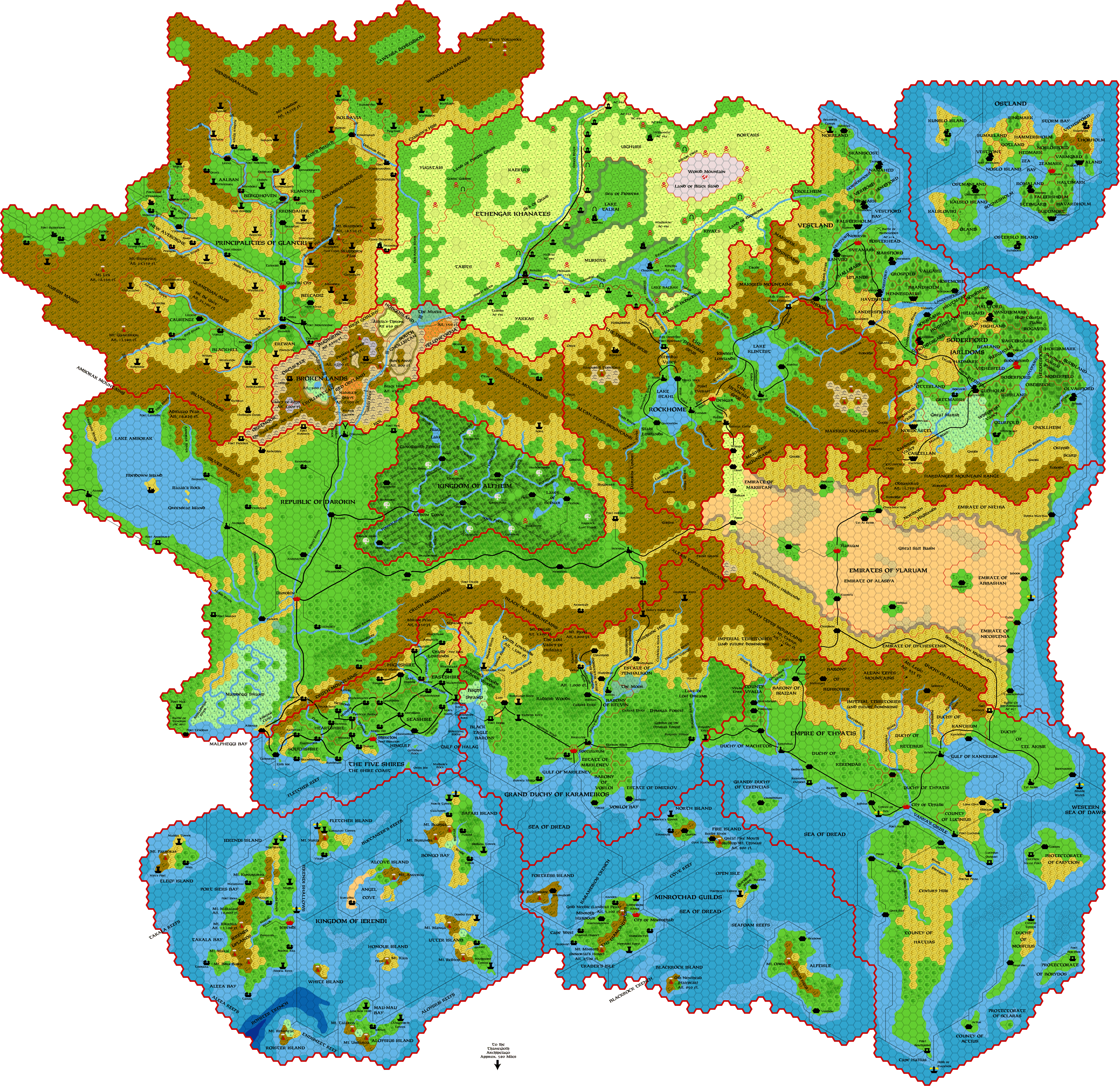
I just finished and uploaded the Ylaruam map with smoothed out plateaus. You can see it near the start
of this thread, or click here.
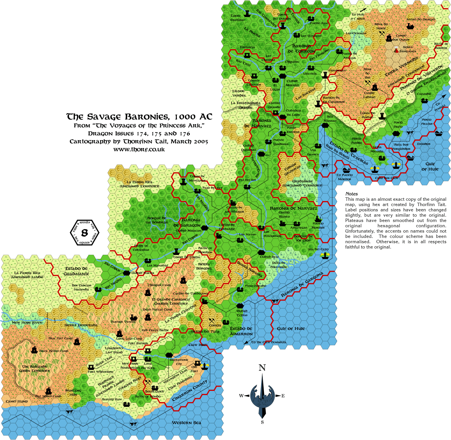
And I have also pasted together the Gulf of Hule, which actually took a lot more work than I thought it
would - over an hour.

Eventually I will be using the Red Steel maps to add to the Dragon maps. Most notably they provide good
(albeit quite general) details of what lies inland of the Savage Coast. For now, I just referred to them for
details of the areas of ocean that I added in, including the edges of the borders of Narvaez, Gargona,
Almarron and Cimarron.
One problem is that the scans of the Red Steel maps in the PDF that I bought are not very good. If
anyone can help me out with a better scan of those maps, it would be very helpful.
|
15 March 2005, 01:09 AM
|
|
Member
|
|
Join Date: Mar 2001
Location: Italy
|
|
Quote:
|
Originally Posted by Thorf
And I have also pasted together the Gulf of Hule, which actually took a lot more work than I thought it
would - over an hour.
|
Very nice map!
|
15 March 2005, 08:12 AM
|
 |
Member
|
|
|
|
Thorf-
I am continually impressed with the quality of the maps you are making.
These maps alone are the reason I started checking out this forum more
frequently.
Thanks for sharing your great work!
__________________
In the year AC995, Traianus Decius Aureus- Praetorian Legate, Equites Laurifer, twice honored with Triumphs, bearer of the Corona Civica, Corona Muralis and Corona Obsidionalis
-delivered the motherland from the Thyatian occupation and was raised
to the purple by the Praetorian Guard and the Legions. Long may he
reign with strength and wisdom.
|
15 March 2005, 11:02 AM
|
|
|
Amazing! Thank you Thorf!
|
15 March 2005, 12:03 PM
|
 |
Member
|
|
Join Date: Apr 2004
Location: Long Beach, CA
|
|
Quote:
|
Originally Posted by Thorf
One problem is that the scans of the Red Steel maps in the PDF that I bought are not very good. If
anyone can help me out with a better scan of those maps, it would be very helpful.
|
Don't know about the PDF version, but have you checked the versions released here on the Wizards site a long time ago? It has a map, and I think it's pretty good quality, IIRC.
|
15 March 2005, 01:59 PM
|
 |
UnCon Prizewinner
|
|
Join Date: Mar 2005
Location: USA
|
|
|
15 March 2005, 03:30 PM
|
|
Member
|
|
Join Date: Jan 2005
Location: Akita, Japan
|
|
Quote:
|
Originally Posted by Cthulhudrew
Don't know about the PDF version, but have you checked the versions released here on the Wizards site a long time ago? It has a map, and I think it's pretty good quality, IIRC. |
The PDF version has the map, but of course it's in pieces, and fitting
it together is even more problematic than usual, because it doesn't
have a useful hex grid to line things up with.
Unfortunately, the Savage Coast downloads don't include the poster maps
that came with Red Steel. And worst of all, I never got round to buying
the actual books myself, so I haven't even seen the poster maps other
than in the PDFs...
Quote:
|
Originally Posted by Culture20
|
Thanks for the links. I've already been using the Voyages of the
Princess Ark maps, as you can see by the sources I've listed. But the
Red Steel maps are different - no hex grid, and since they're poster
maps, they show all the inland terrain too. As far as I know, they are
not posted anywhere online.
Ironwolf almost certainly made reference to the Red Steel maps too, as
evidenced by his additions to the Princess Ark maps (the northern
border of Guadalante, to name one example).
|
15 March 2005, 09:15 PM
|
|
Member
|
|
Join Date: Jan 2005
Location: Akita, Japan
|
|
 Break for a few days
Sorry
guys, but there's going to be a break for the next few days. I have my
last class for this term tomorrow, and therefore the last visit to my
school until probably late May. That alone makes me incredibly busy,
but as it turns out I will be busier still. I was planning on going to
Tokyo next week for an interview at the British Embassy (I have to get
a certain document to allow me to get married here), but it has been
brought forward, and I will instead be leaving tomorrow right after
work! 
I'll be back on Thursday night, late. In any case, it's looking as if I
won't get back into the way of things until next week. So, for now I'm
going to plan to take a break until Monday.
By the way, it was exactly one month ago today that I started posting
maps. So my first batch of daily maps lasted a whole month!
One last thing. As a little bonus prize for you all for staying with me
up until now, here is a very simple, provisional version of that map
I've been working on for the last few weeks. It's full of uncorrected
mistakes, doesn't have any of the recent revisions (palette, contours,
etc.) and is in the old low resolution. But it ought to let you get a
feel for what the finished one will look like.
(Note: I know there are lots of errors in this map, but don't worry
about them for now. Most of them have in fact been corrected already,
and the final version, hopefully in a few weeks, will include the
corrections and more.)
Click here to see the map.
And with that - see you next Monday!! 
|
17 March 2005, 04:01 AM
|
 |
Member
|
|
Join Date: Jan 2004
Location: Tenh
|
|
Quote:
|
Originally Posted by Thorf
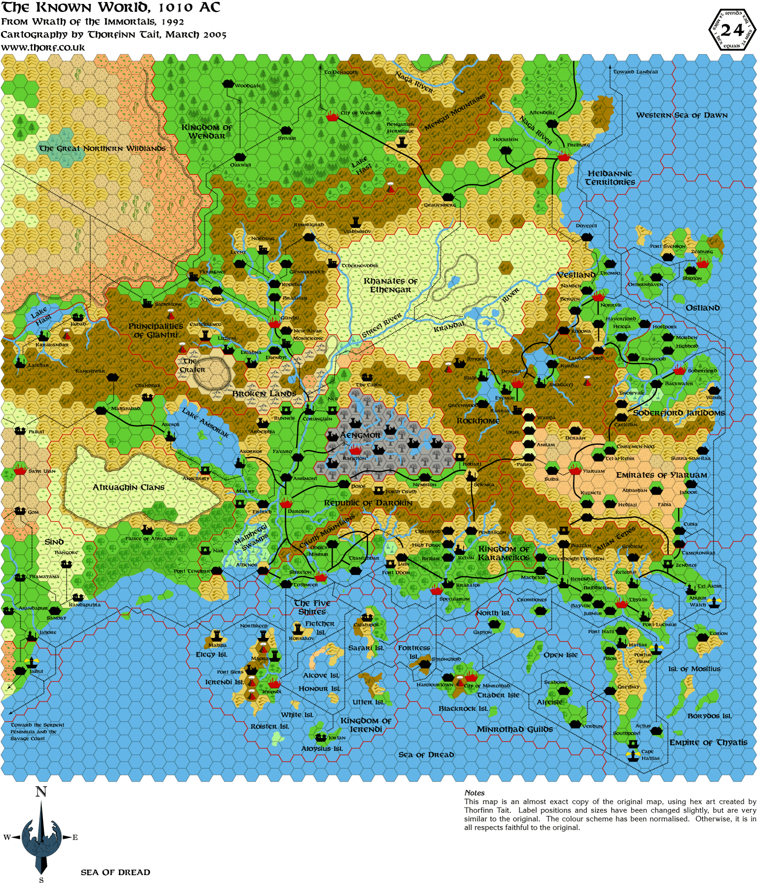
Otherwise, this should be a completely up to date map of Ylaruam for AC 1000.
|
Thorf, I can't seem to find the Lost City of the Cynidiceans (B4) on
your Ylaruam map. Was it left out for a reason or simply - pardon the
pun - lost?
__________________
Mortepierre Malepeste
Dwarven Necro.. er.. Student of Anatomy
|
22 March 2005, 03:20 AM
|
|
Member
|
|
Join Date: Jan 2005
Location: Akita, Japan
|
|
Update
Quote:
|
Originally Posted by Mortepierre
Thorf,
I can't seem to find the Lost City of the Cynidiceans (B4) on your
Ylaruam map. Was it left out for a reason or simply - pardon the pun -
lost?
|
I haven't marked it on yet because it's not marked on any of the
official versions of the 8 mile per hex map. It is marked on the Expert
Set map (or maybe X1 - I don't recall offhand), so when I eventually
get to including information from 24 mile per hex maps too, I'll add it
in.
Thanks for noticing! 
Well, Monday has been and gone here, and I haven't posted a map for you
yet. I had a busy week and weekend, with a friend visiting from the
States, and my last day of lots of work is tomorrow. So I'm afraid
you're going to have to wait until tomorrow for me to start posting
maps again.
But... I do have a pretty cool map to start things off again. So be sure to check back here tomorrow! 
|
22 March 2005, 09:30 AM
|
|
Member
|
|
Join Date: Jan 2005
Location: Akita, Japan
|
|
Tuesday's Map
I have an unexpected spare moment, so here is today's map, much earlier than I expected.

As you can see, it's an upgraded version of my previous map. It took a while to add in the walls, but I think it
was well worth doing. The walls themselves are basically just random squiggles. Mostly I kept them quite
simple, but you can see an example of more complex squiggles in the bottom right, where I went all out for the
last few lines.
|
22 March 2005, 09:34 AM
|
|
Member
|
|
Join Date: Apr 2004
Location: Long Beach, CA
|
|
I
like the cavern wall map version- I always wanted to do something like
this with Gaz13's map myself, but never got around to it. Have you
thought about adding connecting caverns in place of the trail markers?
To get something even more like the Gaz10 maps?
|
22 March 2005, 12:26 PM
|
 |
Member
|
|
Join Date: Mar 2004
Location: Ontario, Canada
|
|
NICE! I definately prefer the cavern wall version over the straight hex sides. Well done.
|
22 March 2005, 03:24 PM
|
|
Member
|
|
Join Date: Jan 2005
Location: Akita, Japan
|
|
Quote:
|
Originally Posted by Cthulhudrew
Have you thought about adding connecting caverns in place of the trail markers? To get something even more like the Gaz10 maps?
|
Yes, I thought about doing this, but I have two issues with changing
the dotted lines into proper tunnels. The first is that it will take a
long, long time to do, which of course is the primary reason that I
left the tunnels as they are. The second is that I'm not sure whether
they would really be any better drawn in with cavern walls. Or rather,
I'm loath to introduce another feature that looks precisely accurate
but is in fact exaggerated - in this case, the tunnel width would be
grossly exaggerated in most cases.
On the other hand I agree it would at least look better, so I will probably draw them in eventually.
I'm a little surprised no one has commented on the City of the Stars
cavern yet. I'm strongly considering revising it to fit the style of
the other caverns, even though that would also mean revising the
detailed 2 mile per hex map of that cavern, from which the current
version was derived. The problem is that the current cavern fits the
hexes just a little bit too well for my liking.
|
23 March 2005, 02:08 AM
|
|
Member
|
|
Join Date: Jan 2005
Location: Akita, Japan
|
|
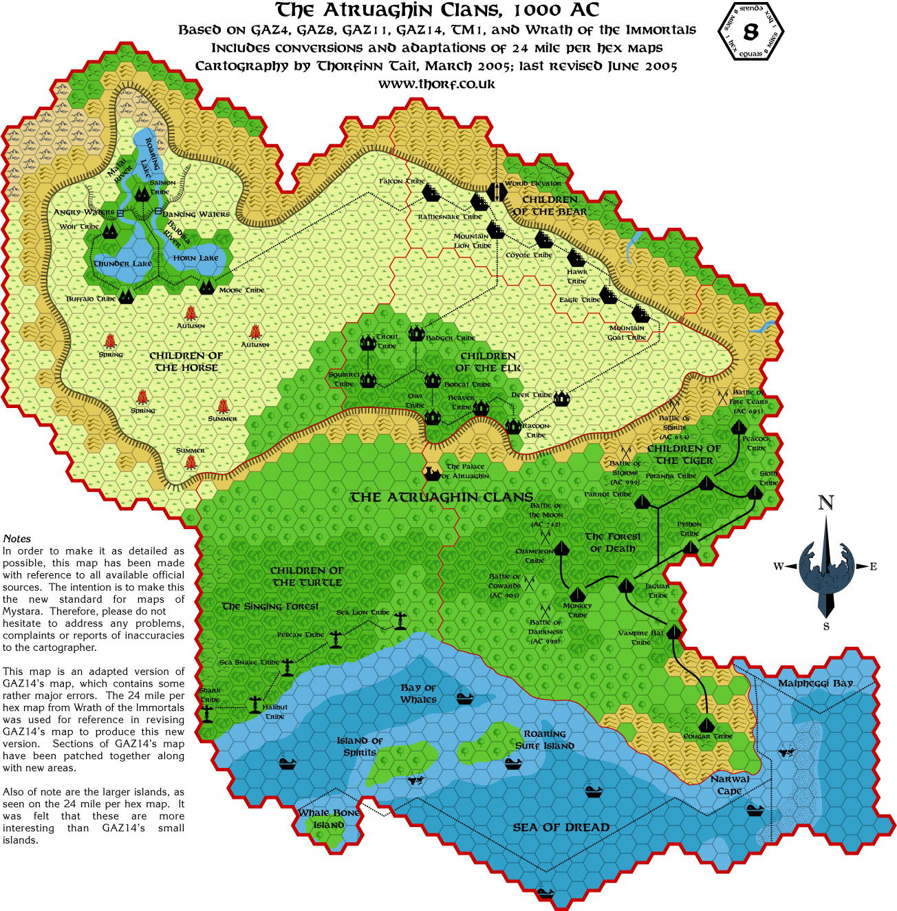
Atruaghin
Tonight
I did most of my revised Atruaghin map. I still have to sort out the
border between the Turtle Clan and the Tiger Clan, but otherwise it's
complete.
In doing so I noticed a number of things about the maps. First, GAZ14's
Atruaghin Plateau doesn't really fit any of the 24 mile per hex
plateaus. I initially thought that it was just missing the bit in the
middle, but actually it's just an entirely different shape altogether.
Bits fit together here and there, but in the end I decided to go with a
hybrid form of the Wrath of the Immortals plateau and the GAZ14
plateau, averaging out both outlines to create a new one that resembles
both, while matching neither perfectly.
Second, the small islands in the bay, marked on all 24 mile per hex
maps, are totally out of scale on the GAZ14 map. Since the GAZ14
islands are extremely hexy, I decided to go with the bigger islands.
This makes the bay more interesting as well as bringing it into line
with the larger scale maps. In the process I fixed the border
discrepancies, which are many and rather drastic on GAZ14's map.
Last, as I believe Andrew has pointed out before, the Turtle Clan and
the Tiger Clan don't have a lot of space, and are rather crushed
together. Surely the Turtle Clan should have been wiped out by now.
Also, I noticed that all the battle sites were marked inside
Tiger Clan territory. This would presumably mean that they like to draw
their enemies into their own territory before fighting, or they fight
amongst themselves a lot. Or maybe that the Turtles are the aggressive
tribe after all!
It would seem better to put the battle sites close to the Turtle Clan,
preferably within their territory, since generally they are the ones
being attacked. I'm also considering widening the space between them
and the Tigers, while spacing out each tribe's villages a little more.
This alone should solve the problem of extra space - although I did
like Andrew's Viper Tribe ruins idea too.
I will post the map either tomorrow or Thursday, depending on how
things go. Either way, I'm definitely back to posting maps daily again
so check back tomorrow for another one. 
|
23 March 2005, 07:52 AM
|
 |
Member
|
|
Join Date: Mar 2005
Location: UK
|
|
Great maps Thorf.
Here are some suggestions for the Karameikos map.
Rifllian. On careful inspection of GAZ1 and the trail map, the shading seems to be heavy forest.
Riverfork keep. I would move it south 1 hex so that it commanded the confluence of the rivers.
Original mapping errors by TSR.
Kelvin is at the confluence of the Volaga and Shutturgal rivers and
should be moved south 1 hex to reflect this (reference Gaz1 detail of
Kelvin)
Threshold is situated west of the river waterolde, and south of a lake
(reference Gaz1 detail of Threshold). So need more water in the
Threshold hex.
Castellan Keep - I've started a thread about this. IMC I'ved always moved it out of the moutains downriver
|
23 March 2005, 08:01 AM
|
|
Member
|
|
Join Date: Mar 2004
Location: Ontario, Canada
|
|
Quote:
|
Originally Posted by Thorf
Bits
fit together here and there, but in the end I decided to go with a
hybrid form of the Wrath of the Immortals plateau and the GAZ14
plateau, averaging out both outlines to create a new one that resembles
both, while matching neither perfectly.
|
My personal preference is to give the plateau as much area as possible.
I think the clans require a lot of room to roam around in. Still, I'm
interested to see what your version ends up looking like. If Andrew's
map has a larger area for the plateau, I'll be sticking with that one,
but by creating another vision of what the plateau may be like, you
provide another option for people to exercise their preference.
Quote:
|
Also, I noticed that all the battle sites were marked inside
Tiger Clan territory. This would presumably mean that they like to draw
their enemies into their own territory before fighting, or they fight
amongst themselves a lot. Or maybe that the Turtles are the aggressive
tribe after all!
|
What if those battles were in Turtle Clan Territory
when they occured, perhaps changing the shape of the borders. This
likely has happened many times in the past; the border shifting and
slanting back and forth.
Quote:
|
Either way, I'm definitely back to posting maps daily again so check back tomorrow for another one.
|

|
23 March 2005, 02:05 PM
|
|
Member
|
|
Join Date: Jan 2005
Location: Akita, Japan
|
|
Wednesday's Map
Replies later, for now I only have time to post a map.
There will be a second map for the 1004 AC version tomorrow or the day after.
Comparing this map with X11's Wendar and Denagoth is rather interesting.
Otherwise, this map is full of errors and took me ages to make because remaking a map full of errors takes
more motivation than usual... Adjusting the borders so that they are wrong was especially galling. 
Anyway, more of this dicussion later when I have time.
|
23 March 2005, 05:46 PM
|
 |
Member
|
|
Join Date: Apr 2004
Location: Denmark
|
|
It is a great map, Thorf, but can you please add the names of all the isles in the Empire of Thyatis and not just half of them?
Keep up the great work!
(Looking forward to the AC 1004 map, because I don't use WotI )
:-) Jesper
|
23 March 2005, 09:48 PM
|
|
Member
|
|
Join Date: Jan 2005
Location: Akita, Japan
|
|
Some replies...
Quote:
|
Originally Posted by Chris.Nix
Rifllian. On careful inspection of GAZ1 and the trail map, the shading seems to be heavy forest.
|
Good catch. When I made the Gazetteer maps I didn't have a separate
heavy forest hex colour, hence the mistake. I've fixed it in my files.
Quote:
|
Riverfork keep. I would move it south 1 hex so that it commanded the confluence of the rivers.
|
Judging by the position of the trails in the area (as shown on TM1),
I'd say the current position is fine - the trails presumably indicate
the best places to cross the rivers, in which case Riverfork Keep is
placed with one ford in front of it and two behind.
Quote:
Original mapping errors by TSR.
Kelvin is at the confluence of the Volaga and Shutturgal rivers and
should be moved south 1 hex to reflect this (reference Gaz1 detail of
Kelvin) |
Yes, you're right. The detail map of Kelvin does indeed clearly show it
to be at the confluence of the rivers. Unfortunately none of the
official maps have this marked correctly.
Further investigation into this issue brought up even more problems. It
seems that the original names of the Windrush and Hillfollow Rivers
each have multiple versions, and indeed the position of the rivers has
changed over time too. The Expert Set originally had the three rivers
meeting in the same place, with Kelvin situated there. This was later
changed for GAZ1's map, and that version has been used ever since, with
the Windrush meeting the Hillfollow before joining up with the
Highreach. It looks as if Kelvin remained at the original confluence of
the three rivers, though.
As for the names, GAZ1's map provided the names Waterolde and
Shutturgal. However, the text refers to Shutturga and Wufwolde. The
detail map of Threshold sticks with the hex map's Waterolde, the Kelvin
detail map keeps the text's Shutturga. Later, TM1 included Shutturgal,
but changed Waterolde to Waterholde. Finally Karameikos: Kingdom of
Adventure kept Shutturga and Wufwolde in the text, but eliminated them
altogether from the map. It seems to me that Wufwolde is the most
likely name, because the hills around the river are the Wufwolde Hills.
As for Shutturgal, it could go either way but Shutturga seems to be
better represented.
Yes, it seems that Karameikos is not nearly as simple a map as we all thought...
Quote:
|
Threshold is situated west of the river waterolde, and south of a lake
(reference Gaz1 detail of Threshold). So need more water in the
Threshold hex. |
You're right again, apparently there is a Windrush
(Waterolde/Waterholde/Wufwolde) Lake north of Threshold. In actual fact
this is marked on the map in B10, but I really don't want to bring B10
into this conversation. I'm having nightmares about dealing with it
already.  
(To cut a long story short, as far as I can see B10 has Threshold where Verge is now located. This is a big headache.)
Quote:
|
Castellan Keep - I've started a thread about this. IMC I'ved always moved it out of the moutains downriver
|
You are of course free to do this, and your reasoning may be sound, but
as far as I am concerned the description in the Gazetteer fits the
location pretty well, so I'll follow my usual policy in making these
maps, which is to only change things if there is overwhelming evidence
that they are wrong.
Thanks for all these corrections by the way! I very much appreciate it.
Quote:
|
Originally Posted by Hugin
My
personal preference is to give the plateau as much area as possible. I
think the clans require a lot of room to roam around in. Still, I'm
interested to see what your version ends up looking like. If Andrew's
map has a larger area for the plateau, I'll be sticking with that one,
but by creating another vision of what the plateau may be like, you
provide another option for people to exercise their preference.
|
There probably won't be a huge difference between Andrew's map and
mine, although I haven't compared them much yet. If anything, Andrew's
version of the plateau will be smaller than mine, I think, because I
believe he kept his map faithful to the 8 mile per hex map while adding
the middle of the plateau back in, and the 8 mile per hex plateau is
actually inherently smaller than the 24 mile per hex versions.
Anyway, you'll see very soon I hope.
Quote:
|
What if those battles were
in Turtle Clan Territory when they occured, perhaps changing the shape
of the borders. This likely has happened many times in the past; the
border shifting and slanting back and forth. |
That's a possibility, yes. Although there isn't that much land for the
border to shift back and forth in. Also, one of the battles (mid 8th
Century) is right next to one of the Tiger Clan villages. I guess it
could be a newer village...
With the increased space, though, I think I will probably space the battles out a lot more.
|
23 March 2005, 09:56 PM
|
|
Member
|
|
Join Date: Jan 2005
Location: Akita, Japan
|
|
Wrath of the Immortals map
Quote:
|
Originally Posted by Spellweaver
It is a great map, Thorf, but can you please add the names of all the isles in the Empire of Thyatis and not just half of them?
Keep up the great work!
(Looking forward to the AC 1004 map, because I don't use WotI )
:-) Jesper |
I guess I should make this clearer when I post, but this map is a
replica rather than an updated map. It includes all the errors and
omissions that came with the original, which in the case of this map is
a lot: - Atruaghin
islands – the islands in the bay are in different positions from those
in GAZ14, and are larger too. Champions of Mystara later duplicates
this "error", as does the AD&D 24 mile per hex map. Personally, I
prefer the bigger islands.
- Atruaghin plateau – this map shows
the whole Atruaghin plateau for the first time in this scale. It
confirms the inaccuracy of GAZ14’s 8 mile per hex map.
- Borders
– the borders for most countries on the map are inaccurate when
compared with the 8 mile per hex Gazetteer maps. They are also very
different from the borders in the original Expert Set map. Indeed, the
borders shown on this map are inconsistent with virtually all other
maps.
- Chandbali trail – this trail leading off the Akesoli-Mahasabad road/trail is missing.
- Glantri-Wendar
border – the border shown on this map is very different from the GAZ3
border. Large sections of mountains and forested hills have been ceded
to Wendar.
- Jaibul’s border – the southern border of Jaibul goes
too far south when compared to the Champions of Mystara map. Since this
map shows only the edge of Jaibul, it’s likely that this map holds the
mistake.
- Jaibul trails – the two trails leading south and west from Jaibul are missing from the edge of this map.
- Latehar
– this Sindhi town is shown as a city. Both other sources have Latehar
as a town. Addition-ally, it is shown as a plains town in the
mountains. In Dragon 169 it was a hill town, and in Champions of
Mystara it is a mountain town.
- Latehar trail – the trail leaing northwest from Latehar, which should be visible leaving the edge of the map, is missing.
- Mis-spellings
and Typos – Bengarian Hermitage (Bensarian Hermitage), Briddleton
(Bridleton), Cinsa-men-Noo (Cinsa-Men-Noo), Forth Cruth (Fort Cruth),
Surra-man-Raa (Surra-Man-Raa), Tel-al-Kebir (Tel al Kebir).
- River Devoki – this seasonal river on the Adri Varma Plateau is missing. Presumably it was added in Champions of Mystara.
- Shipping
lanes – the shipping lanes along the Sind and Jaibul coast have been
moved one hex out to sea. Champions of Mystara later puts them back in
their original Dragon 169 position.
- Sind-Jaibul border – the
Jaibul border extends two hexes further east into the sea, and the Sind
border one hex further east than either Dragon 169 or Champions of
Mystara show.
And I haven't even finished this list. Other points include the
positioning of settlements (Thyatis City and the towns along the coast,
for example), the hex type chosen for numerous hexes, and so on. All in
all, it's without a doubt the worst map TSR made for Mystara. By a long
way.
So, no small surprise that they forgot to label a few Thyatian islands.
Edit: Oh yeah, and I'm surprised no one noticed the "Lake Dast" label in the middle of the Wendar. That one was of course my mistake...
|
24 March 2005, 07:31 AM
|
|
Member
|
|
Join Date: Mar 2005
Location: UK
|
|
Another great map Thorf.
Quote:
|
Originally Posted by Thorf
Yes, it seems that Karameikos is not nearly as simple a map as we all thought... |
I'll have to dig out all the relevant modules and go through them with
a fine tooth comb, and come up with a consistant naming standard for my
campaign.
 Thanks TSR.
Thanks Thorf Now at last I have a decent electronic replica of the original maps to play with
|
24 March 2005, 07:53 AM
|
|
Member
|
|
Join Date: Apr 2004
Location: Long Beach, CA
|
|
Quote:
|
Originally Posted by Thorf
You're
right again, apparently there is a Windrush
(Waterolde/Waterholde/Wufwolde) Lake north of Threshold. In actual fact
this is marked on the map in B10, but I really don't want to bring B10
into this conversation. I'm having nightmares about dealing with it
already.
(To cut a long story short, as far as I can see B10 has Threshold where Verge is now located. This is a big headache.)
|
I'd almost forgotten about this. I did a version of Karameikos with the "Lost Valley" from B10 drawn in (available on the Vaults,
though they seem to be down today), and then tried to do a 1 mi/hex map
of the Verge/Threshold region and noticed the same thing.
Threshold is definitely in the wrong location on the large scale map,
Verge should be higher up, and that river should actually go higher up
into the mountains than it does.
Unfortunately, the problem is compounded by the fact that the hex maps
in B10 (the most detailed of the region) are oriented differently than
the traditional hex maps!
I may have a version (in 8 mi/hex) where I corrected that. Not sure. In
any case, I think we just have to chalk that one up to differences in
scale, and just deal with the differences when using smaller map scales
if you do.
|
24 March 2005, 09:31 AM
|
|
Member
|
|
Join Date: Jan 2005
Location: Akita, Japan
|
|
Thursday's Map
Well, here it is - for your criticism and enjoyment.
See my post from yesterday for comments on this map.
Last edited by Thorf : Today at 03:36 PM.
|
24 March 2005, 11:10 AM
|
|
|
HexMapper
Quote:
|
Originally Posted by Thorf
Ironwolf
almost certainly made reference to the Red Steel maps too, as evidenced
by his additions to the Princess Ark maps (the northern border of
Guadalante, to name one example).
|
That I did.
I wasn't all that concerned with trying to follow the original maps,
mistakes and all. I was running a Red Steel campaign and I needed maps
that I could use. So when I ran into areas that weren't defined by
hexes, I used the non-hex maps as a guideline, and extrapolated the
areas.
Just to add to the general confusion, I also started a hex-mapping
program also called "HexMapper". (Not to be confused with the HexMapper
program Thorf used.) It was a GUI application written in C#, I did
distribute a link to it on the Mystara boards last spring.
I never finished it, because it was for a UI class and I got enough
done to pass with flying colors. I ran into optimization issues, and I
also had to write my own version of Paint for it, a more daunting task
than apparent. And finally, I really didn't get a lot of interest from
people on the boards in the program. So, I felt no inclination to
finish it. Since Thorf's work seems to be going over well, looks like I
need not bother.
For the record, all the alterations to the Savage Coast maps I did,
including the 8 mile per hex version of the Dark Jungle, are my own
work. No need to go hunting down obscure sources.
Adamantyr
Last edited by Adamantyr : 03-24-05 at 11:24 AM.
|
24 March 2005, 11:35 AM
|
|
Member
|
|
Join Date: Apr 2004
Location: Long Beach, CA
|
|
Thorf's Atruaghin Fix
Nice-
I like it a lot, especially with the rounded plateau contours. It
doesn't seem that different from my map, except that there seems to be
a bit more plateau near the middle-central on yours. IIRC, the reason I
went with the version I have is because the reduced plateau size on my
current version fit better with the "ends" so to speak- the eastern and
western portions of the plateau that existed and seemed (more or less)
to fit the larger scale version.
I also prefer your larger sized islands. I couldn't quite figure out
what to do with them on my map, both due to the size differences
between the 24 and 8 mile maps, as well as the displacement of their
location due to adding several miles worth of coastline between the
Tiger and Turtle clan lands. I agree with you that the larger islands
seem more aesthetically pleasing. I'd be inclined to drop a Turtle Clan
hold on one or more of them, frankly.
One suggestion I have, though- a couple of your Bear Clan towns are
currently located atop the plateau itself. They should probably be
moved directly to the edge of the plateau, as the Bear Clan holds are
all supposed to be cliff dwellings.
|
24 March 2005, 11:36 AM
|
|
Member
|
|
Join Date: Mar 2004
Location: Ontario, Canada
|
|
Nice.
I'm still comparing your map with Andrew's and I'm finding the
differences interesting. There's many of them; mostly small ones, but
that makes the maps fun to look at!
Now for some thoughts:
I like the larger islands. I still can't make up my mind if I prefer
your location of the islands or the ones Andrew used. I noticed you
smoothed out the Bay of Whales where the shore reaches its
northern-most point.
The northern border is quite different between the maps. An earmark of
the different approaches perhaps. I also thought that the southern
border would come out around Whale Bone Island more (but I know you're
following the WotI map on that).
I just got curious as to why or how the Roaring Lake got its name.
Anybody know, or have a theory? I mean, I can easily see a river having
the name "Roaring", but what about a lake? I wonder if the lake has a
spot by the northern shores near the broken land where it becomes an
underground river that flows to Lake Amsorak. Hmmmm...
Last thought (for now). I found it interesting that the border of the
Tiger Clan sticks to the shoreline. I take that as an indication that
the Tiger Clan do not take to the Sea at all.
Great looking map, Thorf!
|
24 March 2005, 11:50 AM
|
|
Member
|
|
Join Date: Mar 2004
Location: Ontario, Canada
|
|
Quote:
|
Originally Posted by Cthulhudrew
I'd almost forgotten about this. I did a version of Karameikos with the "Lost Valley" from B10 drawn in (available on the Vaults,
though they seem to be down today), and then tried to do a 1 mi/hex map
of the Verge/Threshold region and noticed the same thing. |
Thanks for the link, I'll check it out as soon as the Vaults starts working again.
Quote:
|
One suggestion I have, though- a couple of your Bear Clan towns are
currently located atop the plateau itself. They should probably be
moved directly to the edge of the plateau, as the Bear Clan holds are
all supposed to be cliff dwellings. |
Thorf's theme so far has been to keep to the originals as much as
possible, with corrections to be done later. But keeping the icons on
the top of the plateau might be better anyhow. I've always thought that
although they were on the cliff face, they were very close to the top,
perhaps even cresting the edge to expand onto the top in some cases.
Edit: Alright, the Vaults are up again and I've seen those maps. I
remember them from a long time ago and wasn't sure where they belonged.
I thought they may have been of the Lost Valley, but I'm still not
sure. Any help Andrew, I've been dying to find out for sure? And what
is the scale?
Last edited by Hugin : 03-24-05 at 12:08 PM.
|
24 March 2005, 12:51 PM
|
|
Member
|
|
Join Date: Apr 2004
Location: Long Beach, CA
|
|
Quote:
|
Originally Posted by Hugin
The northern border is quite different between the maps. An earmark of the different approaches perhaps.
|
I deliberately changed the northwestern border for personal reasons-
primarily, I plan (down the road) to expand that Broken Lands territory
between Sind and Atruaghin into the new homeland for the descendants of
the Red Orcs that plagued both nations a long time ago.
Also, I just thought the existing borders there were odd- either one
nation, the other, or neither (IMO) should lay claim to it- yet they
were dividing up badland territory between them...
Quote:
|
I just got curious as to why or how the Roaring Lake got its name.
Anybody know, or have a theory? I mean, I can easily see a river having
the name "Roaring", but what about a lake? I wonder if the lake has a
spot by the northern shores near the broken land where it becomes an
underground river that flows to Lake Amsorak. Hmmmm... |
I was along the same lines myself. Actually, my work on combining the
B8: Journey to the Rock map with the Sind/Atruaghin maps had the
Roaring Lake feeding the lake outside of Tuma.
|
|
|