Thorf's Secret Project: Stage One
A recreation of the Mystara Message Board thread that started the Atlas of Mystara project, with restored links and images.

Jul 06, 2005 2:08:41
|
 |
|
|
Join Date: Jan 2005
Location: Akita, Japan
|
|

Quote:
|
Are you also planning to do all the maps from the surface gazeteers or the Poor Wizard's Almanac?
RPGpundit
|
Sorry, I should have been clearer. There are still quite a lot of Outer World maps to do, mostly in the 72 mi per hex scale. But when it comes to the Hollow World, the sources are much more limited:
- Hollow World projection map, non-hex
- Northern and Southern Iciria maps, 40 mi per hex
- Azcan Empire map, 8 mi per hex
- Kingdom of Nithia Delta Kingdom and Southern Kingdom maps, 8 mi per hex
- Milenian Empire map, 8 mi per hex
- Ashmorain map, ? mi per hex
- Shajapur map, 8 mi per hex
- A few non-hex maps from the Poor Wizard's Almanacs
The Iciria map is a great source for developing the majority of the Hollow World, because it deals with so much ground. The 40 mi per hex scale turns out to be friendlier than the Outer World's 72 mi per hex scale, too.
I have great hopes that the projection map can be used to expand the Iciria map to cover the whole of the Hollow World, but unfortunately it doesn't seem to be as compatible as I had hoped. Still, it should be possible.
The 8 mi per hex maps cover only a small area of the world, but thanks to the 40 mi per hex map, they should be easily expandable.
Lastly, the Shajapur map is the only source we have for a non-Icirian area of the Hollow World, but unfortunately the hex grid is set at a 90 degree angle to the rest of Mystara's maps, so it will require some conversion. (The same problem appears occasionally elsewhere, most notably the Isle of Dread large scale maps in X1.)
I only wish the Outer World maps were as simply summed up in a few paragraphs, but the history of the world combined with the sheer number of sources makes the situation a lot more complex.
By the way, I can't check right now because I'm at work, but I don't think any of the Hollow World maps provided in the Poor Wizard's Almanacs give any new information. They tend to be useful as reference materials, though - for example I used the Traldar Kingdoms one to help resolve the continuity problems for that area on my combined map of Iciria. (The original Northern and Southern Iciria maps both show that area a little differently.)
|
Jul 06, 2005 2:28:22
|
 |
|
|
Join Date: Jun 2005
Location: Uruguay
|
|
No I think you're right.. the PWA provides a lot of info as to changes in the outer world; and covering new ground like Davania.
But as far as I've seen the ONLY "changed" map of the hollow world would be to add the border and city for Alphatian Neatharum.
RPGpundit
|
Jul 06, 2005 3:16:03
|
 |
|
|
Join Date: Apr 2004
Location: Long Beach, CA
|
|
Quote:
|
I always assumed that the exaggeration was merely for purposes of clearity. It doesn't show any of the river's finer meanderings or width variations. I guess you could say it's a rough guide in the same manner that the hex symbols are a rough representation of the area's terrain.
|
I agree. You can see this in particular clarity with the 1 mi/hex map of Morlay-Malinbois in PC4: Night Howlers. The main river through there, by the large map scale, should also be gigantic, but it is pared down considerably in the 1 mi/hex format, and a lot of new tributaries (not visible on the larger scale) are also seen. Same thing occurs on the 1 mi/hex map of the Dreamlands from PC1: Tall Tales of the Wee Folk. That map depicts the southwestern edge of the Canolbarth, and has tons of little rivers and lakes that are not visible on larger scale maps.
(BTW, Thorf, I'm interested to see how/if you can reconcile the map of the dominion from CM8: Legacy of Blood with the Darokin map around the Dolos region. I've done some preliminary work, but nothing is quite satisfactory at the moment, as the moor from CM8 should not only be visible on the 8 mile/hex map, but Dolos is going to have to be moved a hex south somewhere... just mentioning it because it is close to the PC1 map, and now that you've exhausted the 8 mi/hex maps... heh, heh, heh. 
|
Jul 06, 2005 3:26:12
|
|
|
|
Join Date: Apr 2004
Location: Long Beach, CA
|
|
Quote:
|
The 8 mi per hex maps cover only a small area of the world, but thanks to the 40 mi per hex map, they should be easily expandable.
|
The Hollow World maps have been pretty consistent, I've found, as far as matching the 40 mi/hex map. Certainly compared to the outer world maps.
I've done some maps of the other regions of the HW, notably the Hutaaka Valley, or as we called it in the Hutaaka Gazetteer, the "Valley of the Dogs."
There is a problem with those maps, though- since I did them in pieces, when I was shifting hex maps to get another section, I displaced them by a hex or two- and I haven't ever gotten back and fixed it. 
|
Jul 06, 2005 12:29:15
|
|
|
Join Date: Feb 2005
Location: Ontario, Canada
|
|
Quote:
|
Lastly, the Shajapur map is the only source we have for a non-Icirian area of the Hollow World, but unfortunately the hex grid is set at a 90 degree angle to the rest of Mystara's maps, so it will require some conversion.
|
You can use my map of Selhomarr to map out Suridal. My map covers the central third of the continent at 40 miles per hex, as well as part of the Icirian peninsula that almost touches it.
Geoff
|
Jul 06, 2005 20:21:05
|
|
|
GREAT MAPS!
Do you have any without gridmarking or towns?
I need to stop by here more often.
The Seabed of dread map will help me out a lot for my currenty mystara homebrew, THANKS.
|
Jul 06, 2005 22:01:34
|
|
|
|
Join Date: Jan 2005
Location: Akita, Japan
|
|
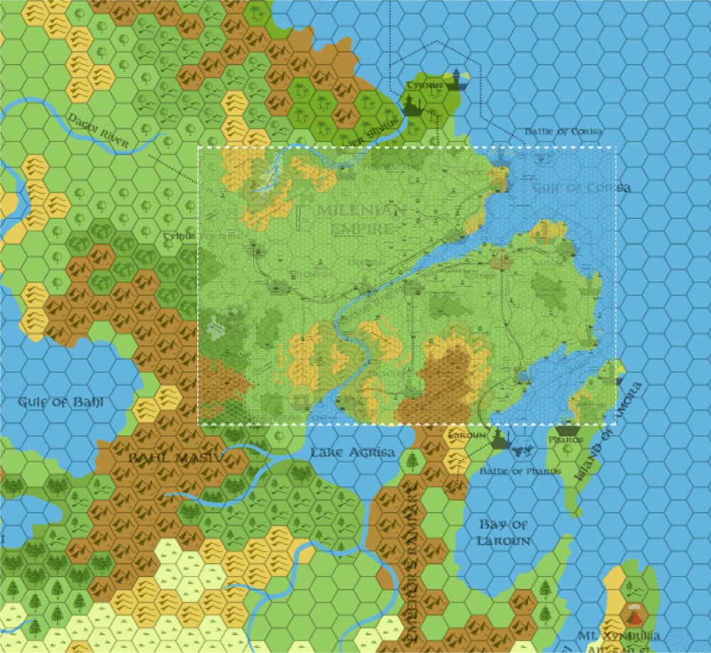
Here's the overlaid maps for the Milenian Empire. It's not nearly as big as the Azcan Empire, and apparently requires very little expansion. Although I'm not entirely sure what lies on their borders.
More replies later. |
Jul 06, 2005 22:21:16
|
|
|
|
Join Date: Jan 2005
Location: Akita, Japan
|
|
Quote:
There is a problem with those maps, though- since I did them in pieces, when I was shifting hex maps to get another section, I displaced them by a hex or two- and I haven't ever gotten back and fixed it. |
As it happens, I had already seen your very nice Hutaaka maps, but I wasn't aware of the HWR. Great work! It's really interesting how it ties in with the Lupins and Gnolls, and it pushed me to finally get round to reading the Lupin article in Dragon 237.
Anyway, I put together another overlay, this time using your Hutaaka maps. I don't see any problems with them, though. Did you mean because they overlap, or what?
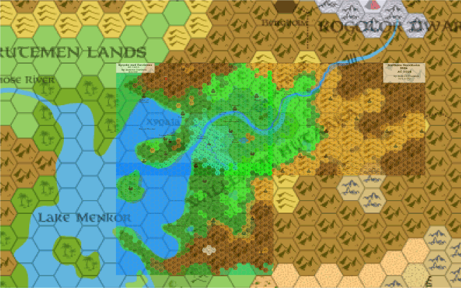
It looks like it will be extremely easy for me to remake your Hutaaka maps into a full map of the area.
|
Jul 06, 2005 23:40:56
|
 |
|
|
Join Date: Mar 2004
Location: Ontario, Canada
|
|
Thank you, Thorf! After years of wondering where those maps (which I now know are Andrew's) belonged, you have finally showed me!  |
Jul 07, 2005 1:19:42
|
|
|
|
Join Date: Apr 2004
Location: Long Beach, CA
|
|
Quote:
|
Anyway, I put together another overlay, this time using your Hutaaka maps. I don't see any problems with them, though. Did you mean because they overlap, or what?
|
For some reason, I got it into my head that I'd messed up a bit around the island in the bay there, and threw off the rest of the maps. I guess I didn't after all, which is nice to know.
I really love these overlays that you've done- they really put things into perspective.
On another note, I do have a fourth map (of the Wulven valley) that I never did get around to posting up- because I hadn't completely developed that region. I should dig it out and see if I ever did complete it.
|
Jul 07, 2005 7:27:15
|
|
|
|
Join Date: Jan 2005
Location: Akita, Japan
|
|
I just updated the map, because earlier I forgot to align it in the same way as the rest of the Hollow World maps. It's not a huge amount different now, though.
I'd love to see your Wulven Valley map, Andrew, even if it's incomplete. We'll have to work on some names for the unlabelled settlements, too.
By the way, I notice that you designed a new symbol. What does it represent? It looks like a mud hut to me.
|
Jul 07, 2005 7:44:47
|
|
|
Join Date: Feb 2005
Location: Ontario, Canada
|
|
Quote:
|
Anyway, I put together another overlay, this time using your Hutaaka maps. I don't see any problems with them, though. Did you mean because they overlap, or what?
|
Wow! Andrew, you really did an excellent job there! Kudos to you, and I'll second Thorf on wanting to see your map (even an incomplete one).
Geoff
|
Jul 07, 2005 10:52:12
|
|
|
|
Join Date: Jan 2005
Location: Akita, Japan
|
|
Hmm, I just noticed that there's a trail/mountain pass leading from the Kogolor town of Bergholm to the Gnollheim Hills. It seems to conflict with the official info on the Hutaakans, as well as the Hutaakan HWR, neither of which mention contact with the Kogolors. 
Anyone got any ideas? Do the gnolls prevent the dwarfs from going that way? That could work for the present, but the gnolls are a relatively recent arrival...
I'd rather find some sort of expanation rather than just ignore the trail altogether. |
Jul 07, 2005 11:59:26
|
 |
|
|
Join Date: Feb 2004
Location: Vienna, Austria
|
|
Quote:
Hmm, I just noticed that there's a trail/mountain pass leading from the Kogolor town of Bergholm to the Gnollheim Hills. It seems to conflict with the official info on the Hutaakans, as well as the Hutaakan HWR, neither of which mention contact with the Kogolors.
Anyone got any ideas? Do the gnolls prevent the dwarfs from going that way? That could work for the present, but the gnolls are a relatively recent arrival...
I'd rather find some sort of expanation rather than just ignore the trail altogether. |
This is not official but I just had this rough idea:
Maybe that trail is haunted similar to the one in LotR. It is populated by a strange evil variaty of spectres that nearly was extincted by a LG church a few centuries ago.(any ideas for details?)
Having started to like these undead, the Immortal Nyx chose to save a portion of them and transported them into this secret trail where they lurk for any travelers who dare to enter their land.
|
Jul 07, 2005 12:38:08
|
 |
|
|
Join Date: Sep 2003
Location: Malpheggi Swamp near the Darokin border
|
|
I like that idea. Maybe some kind of powerful spectres. Not like a Balrog, but still dangerous, especially with numerous ones, so adventurers could kill some, but there will always be more.
|
Jul 07, 2005 16:39:21
|
|
|
|
Join Date: Mar 2004
Location: Ontario, Canada
|
|
That sounds like a cool idea for that trail. Maybe in the distant past there was an attempt at contact between the two but something happened; a betrayal perhaps that killed many on both sides and now the dead jealously guard the trail from 'traitors' (read as anyone) that try to use it.
|
Jul 07, 2005 20:14:22
|
|
|
|
Join Date: Apr 2004
Location: Long Beach, CA
|
|
Quote:
|
I'd love to see your Wulven Valley map, Andrew, even if it's incomplete. We'll have to work on some names for the unlabelled settlements, too.
|
I think those were all gnollish camps that I never came up with names for. Probably should just be named after the individual gnollish tribes that inhabit them. There might be some lupin camps, too.
I actually wanted to put more Hutaaka settlements in the valley, because it seems odd that there wouldn't be more hutaaka there after all this time, but the population figure given for hutaaka in the HW DM's guide is incredibly low, and I went with Mischa's argument that the hutaaka themselves were pretty self contained on that little peninsula there. I still think even there we should see a bit more, but...
Quote:
|
By the way, I notice that you designed a new symbol. What does it represent? It looks like a mud hut to me.
|
Oh yeah- it's a mission, where the hutaaka have set up missionaries among the lupins.
|
Jul 07, 2005 20:28:21
|
|
|
|
Join Date: Apr 2004
Location: Long Beach, CA
|
|
Quote:
Hmm, I just noticed that there's a trail/mountain pass leading from the Kogolor town of Bergholm to the Gnollheim Hills. It seems to conflict with the official info on the Hutaakans, as well as the Hutaakan HWR, neither of which mention contact with the Kogolors. |
There isn't much mention of it in the Kogolor HWR either. I'd assume that, given that the gnolls (as we have it) are a recent arrival, they don't conflict much with the dwarves.
Since there really isn't much in the valley, I'd guess that trail is just one the dwarves use occasionally when/if they need to trade or interact with the hutaaka. Since there is no mention of contact between them, it's probably safe to say such contact is rare, but that the dwarves nevertheless keep that route through the mountains open and patrolled.
It's probably a small valley where dwarves live- given that the Kogolor live above ground, rather than beneath it. They might have some fortresses through there that are only visible on a larger scale. Surprised I didn't actually do something with it myself, when I did the maps. I did start a couple of Kogolor maps, continuing from the valley, which I would have put a bit more detail into. I think I forgot about that trail entirely.
As an aside, I was planning on further detailing the Burrower beneath Yoht in my "Meet the Burrowers" articles on the Vaults. IIRC, the one beneath Yoht was going to be either a mutated Brain Collector Burrower or else a Deep Glaurant Burrower. I can't recall which, exactly. Pretty sure it was the former, though.
(I also plan/ned to have the two Burrowers in Nithia, the "towers" of Soth and Sekhaba, be incubus and succubus burrowers. And the cipactli beneath the Azcan lands was going to be a very interesting type of creature. I got hung up on statting them, though, because I wanted to do them in 3E style. I should just go back and do them OD&D style for now, though, just to have them done...)
|
Jul 07, 2005 20:30:10
|
|
|
|
Join Date: Apr 2004
Location: Long Beach, CA
|
|
Quote:
|
That sounds like a cool idea for that trail. Maybe in the distant past there was an attempt at contact between the two but something happened; a betrayal perhaps that killed many on both sides and now the dead jealously guard the trail from 'traitors' (read as anyone) that try to use it.
|
It could also be somehow connected with the Burrower that corrupts the dwarves in Yoht. Though it is a bit further from Yoht, there could still be some connection. Maybe as the altitude decreases from the heights of Bergholm to the valley, the underground, twisted, minions of the Burrower are closer to the surface and more likely to hunt there?
|
Jul 14, 2005 20:12:16
|
stanles
Community Assistant
|
|
Join Date: Mar 2001
Location: Canberra
|
|
Thorf,
the replica map from the Master Set, is it possible to get the Illustrator file for that? I'd like to do something with the linework and if you've already got that in the file then it can save me recreating it.
|
Jul 26, 2005 7:26:22
|
|
|
Hi everyone.
It looks like holidays as there are few answers... Lucky guys 
I updated my website so every Thorf awesome maps are there.
You can download zip file with thumbnails (maybe those aren't updated) and enjoy Thorf great job.
The URL : http://huguesjoneaux.club.fr/MTM/
Greetings.
Ps: I'm sorry for those who are using IE, the website shouldn't be so great. I'm working on it. |
Jul 26, 2005 13:26:29
|
|
|
Wow, you leave Mystara for a little while, and this is what happens! It's going to take me quite a while to navigate through all of this info, but I'm loving every minute of it!
I will definately find some use for these maps in my own ongoing projects!
|
Aug 08, 2005 6:49:04
|
 |
|
|
Join Date: Jun 2003
Location: Liverpool, England
|
|
Hi Thorf,

Any chance of a 8 mile hex map of Glantri post WotI, or least the Great Crater, sometime soon?
Regards,
Gary |
Aug 08, 2005 18:45:06
|
|
|
|
Join Date: Apr 2004
Location: Long Beach, CA
|
|
Quote:
|
Any chance of a 8 mile hex map of Glantri post WotI, or least the Great Crater, sometime soon?
|
that I did several years ago (1998! Yeesh...)
It's a very old palette, the colors are too bright, and it's based on the changes I implemented in the Great Crater mini-gazetteer that I did a long time ago.
I've only ever partially updated the map with my new hex templates, and I never quite finished the maps of the underground (two different levels), but it's a start. Maybe Thorf will take a run at updating this map when he finishes the rest of his official maps.
|
Aug 08, 2005 21:18:33
|
|
|
|
Join Date: Sep 2003
Location: Malpheggi Swamp near the Darokin border
|
|
I hope he does. That would be a very useful map to have indeed.
|
Aug 20, 2005 12:33:41
|
|
|
|
Join Date: Sep 2003
Location: Malpheggi Swamp near the Darokin border
|
|
Hey Thorf. I was wondering what program you're using to make these maps of yours and if there was a way I could get a copy? I was thinking of doing some mapping of my own. |
Aug 21, 2005 2:47:02
|
|
|
|
Join Date: Jan 2005
Location: Akita, Japan
|
|
Finally getting back into the swing of things, and I just remembered that I have yet to reply to quite a bit here... 
Quote:
|
This is not official but I just had this rough idea:
|
Don't worry about that - every idea we have about these largely undeveloped areas is not "official", it's more a matter of trying to keep them in line with what little official stuff we do have. And even then, sometimes it's better to ignore or change the official stuff if it is unworkable.
Quote:
|
Maybe that trail is haunted similar to the one in LotR. It is populated by a strange evil variaty of spectres that nearly was extincted by a LG church a few centuries ago.(any ideas for details?)
Having started to like these undead, the Immortal Nyx chose to save a portion of them and transported them into this secret trail where they lurk for any travelers who dare to enter their land.
|
That's a pretty cool idea! It would certainly prevent the Kogolors from having contact with the gnolls, lupins and hutaaka, while also presenting a very interesting adventure for PCs who wish to take that pass to get from one region to another.
The race itself doesn't have to be unique, rather it could be a community of undead with a specific culture that was in danger on the surface world. (Undead have culture?!? )
Actually another reason that this is interesting is that it would be nice to see some more cultures preserved by Entropic Immortals. Although preservation is somewhat against their principles, transferring entropic communities to the Hollow World would be a very good way to forward many of their plots.
Quote:
|
I think those were all gnollish camps that I never came up with names for. Probably should just be named after the individual gnollish tribes that inhabit them. There might be some lupin camps, too.
|
Okay. I guess I'll remake your map and make a new thread for this subject sometime soon, and we can fill in all the missing names and stuff then.
Quote:
|
I actually wanted to put more Hutaaka settlements in the valley, because it seems odd that there wouldn't be more hutaaka there after all this time, but the population figure given for hutaaka in the HW DM's guide is incredibly low, and I went with Mischa's argument that the hutaaka themselves were pretty self contained on that little peninsula there. I still think even there we should see a bit more, but...
|
I agree with you. Was the explanation for the hutaaka being so few in numbers related to the way they don't always breed true? I can't quite remember how it worked.
In any case, personally I would disregard the official figures and add quite a bit more hutaakans. Official population figures have been drastically revised before, I believe.
Quote:
|
Oh yeah- it's a mission, where the hutaaka have set up missionaries among the lupins.
|
Cool. It's a nice little symbol, I'll have to remake it when I do your maps.
Quote:
There isn't much mention of it in the Kogolor HWR either. I'd assume that, given that the gnolls (as we have it) are a recent arrival, they don't conflict much with the dwarves.
Since there really isn't much in the valley, I'd guess that trail is just one the dwarves use occasionally when/if they need to trade or interact with the hutaaka. Since there is no mention of contact between them, it's probably safe to say such contact is rare, but that the dwarves nevertheless keep that route through the mountains open and patrolled. |
I guess this would work too. I kinda liked the undead valley idea, though.
I don't suppose the Kogolors and the Hutaakans have much in common, actually, and therefore they wouldn't have much reason to stay in contact with each other. Trade is the only reason I can think of for them to interact, but maybe the Hutaaka don't have much that the dwarves would want - and I'm sure hutaakan haughtiness would not go down well with the dwarves.
Quote:
|
It's probably a small valley where dwarves live- given that the Kogolor live above ground, rather than beneath it. They might have some fortresses through there that are only visible on a larger scale. Surprised I didn't actually do something with it myself, when I did the maps. I did start a couple of Kogolor maps, continuing from the valley, which I would have put a bit more detail into. I think I forgot about that trail entirely.
|
It's definitely a borderland type area for the dwarves, but in contrast with their northern border there are no major fortresses marked. I'd say that they might have a keep guarding the pass, but it should be a minor one - the safest and most boring assignment for Kogolor soldiers.
Of course, this could change with the arrival of the gnolls.
I've been planning to do a Kogolor map for quite a while, by the way. It should be a fun area to do, putting little valleys and such in among the mountains.
Quote:
|
As an aside, I was planning on further detailing the Burrower beneath Yoht in my "Meet the Burrowers" articles on the Vaults. IIRC, the one beneath Yoht was going to be either a mutated Brain Collector Burrower or else a Deep Glaurant Burrower. I can't recall which, exactly. Pretty sure it was the former, though.
(I also plan/ned to have the two Burrowers in Nithia, the "towers" of Soth and Sekhaba, be incubus and succubus burrowers. And the cipactli beneath the Azcan lands was going to be a very interesting type of creature. I got hung up on statting them, though, because I wanted to do them in 3E style. I should just go back and do them OD&D style for now, though, just to have them done...)
|
Oohh, this sounds interesting. Where can I find your burrower articles, exactly? Did you do lots of stuff about them? I'd be very interested to read that.
It sounds like you have defined the burrowers as modified versions of monsters...?
By the way, biased though I am towards classic D&D, I would suggest that you forget the stats for the first pass and just do the descriptions. As far as I'm concerned the meat of any monster comes in its description, not its stats. Special abilities make less difference than you might think, too, especially since most really interesting abilities are included in the description anyway.
Quote:
|
Any chance of a 8 mile hex map of Glantri post WotI, or least the Great Crater, sometime soon?
|
I've been thinking about doing that little adjustment for a while. I think I actually started on the map, actually - I remember adjusting some borders, because the dominion borders were changed in a few places for Glantri: Kingdom of Magic.
I'll try to get back to it soon. In the mean time as Andrew said, he did a very nice map of the crater.
Quote:
Hey Thorf. I was wondering what program you're using to make these maps of yours and if there was a way I could get a copy? I was thinking of doing some mapping of my own. |
I use Adobe Illustrator CS2 to do my maps. You can read about it here. I'm afraid that it's a rather expensive professional program, but as such it is extremely powerful. |
Aug 21, 2005 3:07:30
|
|
|
|
Join Date: Apr 2004
Location: Long Beach, CA
|
|
Quote:
|
I agree with you. Was the explanation for the hutaaka being so few in numbers related to the way they don't always breed true? I can't quite remember how it worked.
|
Yeah- that was the explanation we came up with to justify the low population levels.
Quote:
|
I guess this would work too. I kinda liked the undead valley idea, though.
|
Could be a combination. Explorations to the south haven't encountered very much, and the additional aspect of the undead valley would simply be more reason for them not to want to explore and trade with the south. If there were something more worthwhile there, they'd try and do something about the undead.
Quote:
|
I've been planning to do a Kogolor map for quite a while, by the way. It should be a fun area to do, putting little valleys and such in among the mountains.
|
Me too. The trails that are marked are a pretty good indication of where the valleys must lay at a larger scale, and it would be a pretty simple matter of filling in settlements and things along there. I think where I got hung up (as often happens) is with population figures. There just doesn't seem to be much room for "lesser" settlements outside of the ones shown, which would lead to a lot of empty space. Arrgh!
Quote:
|
Oohh, this sounds interesting. Where can I find your burrower articles, exactly? Did you do lots of stuff about them? I'd be very interested to read that.
|
I've only done two so far, and you can read about them at the Vaults. There's an entry for Klarkaszh the Corrupter and D'resh the Destructor. D'resh has a direct connection to the Valley of the Dogs, as it happens.
Quote:
|
It sounds like you have defined the burrowers as modified versions of monsters...?
|
Sort of. The way I have it, in life they were monsters of various statures, mostly of cultures/upbringings that were very anti-Immortal. Klarkaszh was a kopru and D'resh a carnifex, for instance, and both had reasons to dislike the Immortals and their ways. Thanatos found them, converted them to his side, and through a combination of Entropic magics and pacts with Outer Beings, created the Burrowers (the Greater Burrowers, that is).
I still haven't quite come up with a reason for him to have sicced them on the Hollow World rather than the Outer World, unfortunately. That part of the Hollow World history never really made sense, as there was nothing worthwhile in the HW to screw around with. The only beings there were the Brute-Men, and (with Geoff's additions to Mystara) the Lhomarr. So for Thanatos to unleash these creatures with the power to challenge the Immortals on an empty world... really doesn't scan.
Quote:
|
By the way, biased though I am towards classic D&D, I would suggest that you forget the stats for the first pass and just do the descriptions. As far as I'm concerned the meat of any monster comes in its description, not its stats. Special abilities make less difference than you might think, too, especially since most really interesting abilities are included in the description anyway.
|
True enough. The two I have done are in the classic D&D format, fwiw. I should just sit down and do some descriptions and histories of the others that I have in mind.
|
Aug 21, 2005 12:29:37
|
|
|
|
Join Date: Sep 2003
Location: Malpheggi Swamp near the Darokin border
|
|
Quote:
I use Adobe Illustrator CS2 to do my maps. You can read about it here. I'm afraid that it's a rather expensive professional program, but as such it is extremely powerful. |
Thanks Thorf. The link didn't work for me but I can find info on it with a quick search.
|
Aug 21, 2005 15:14:31
|
|
|
|
Join Date: Jan 2005
Location: Akita, Japan
|
|
It seems my home page, http://www.thorf.co.uk, is down. It may have been down for as long as a month, but I've been so busy I didn't notice. 
In any case, my brother is looking into it for me, and hopefully it'll be back up soon. In the meantime you can find all my maps on Shughuy's page at his link a few posts up this page.
Until the problem is resolved, most of the maps embedded in this thread will be offline, so please bear with me. Sorry! |
|
|