Thorf's Secret Project: Stage One
A recreation of the Mystara Message Board thread that started the Atlas of Mystara project, with restored links and images.

25 February 2005, 07:13 PM
|
 |
Member
|
|
Join Date: Apr 2004
Location: Long Beach, CA
|
|
Quote:
|
Originally Posted by Thorf
- Additional
hexes will need to be drawn for the following maps: Nithia (just a few,
pretty easy), Milenia (quite a few, tricky), Undersea (lots, easy but
time consuming), parts of the Savage Coast (just a few, probably easy).
I probably won't start on these just yet, but instead make them as I
need them. Undersea may well be done last, not least because I don't
have a scan of the map, since the PDF file I bought didn't have the map
included.
 
|
I've got quite a few of the hex symbols for Undersea maps in my own
Paint based hex system. If you'd like, you could use them as a template
for your hexes- maybe make the process go a bit quicker. Not sure how
well you can modify .bmp files in Illustrator, though. Let me know if
you want them.
For that matter, I'll see about doing a version of the Undersea map myself, that you can use as a template.
|
25 February 2005, 08:42 PM
|
 |
Member
|
|
Join Date: Jan 2004
Location: Italy
|
|
Well Thorf, first of all CONGRATULATIONS PAL! for your marriage! 
I hadn't quite adjusted myself to the news you were engaged to a
Japanese gal that you already surprise me with the big step , you
devil!
Anyway, I'm curious: where will the ceremony be held? Will your parents
and Mag attend? What kind of ceremony are you planning? What about your
permanent location and job? Where have you scheduled your honeymoon?
When is it all going to happen? And above all... will you hire a
photographer or a mangaka to do your portraits??  
Now on to some frivolous topic, I wanted to warn you about something in
the Darokin map. I remember that the map found in GAZ11 was flawed in
one thing: they had exchanged Mar and Hinmeet's position. Check it out
to see if you got em correctly (haven't got my map here to verify
now)...
Again Thorf, a whole lotta best wishes for your upcoming marriage.. keep us updated!
PS: btw, can we know your bride's name?
|
25 February 2005, 09:39 PM
|
|
Member
|
|
Join Date: Apr 2004
Location: Long Beach, CA
|
|
Quote:
|
Originally Posted by DM
Now
on to some frivolous topic, I wanted to warn you about something in the
Darokin map. I remember that the map found in GAZ11 was flawed in one
thing: they had exchanged Mar and Hinmeet's position. Check it out to
see if you got em correctly (haven't got my map here to verify now)...
|
Good catch- I'd forgotten about that myself!
Looks like Thorf's got the (mixed up) version that the original map
had. Funny thing is, its something that got continued, even after the
errata that pointed it out surfaced (and sometimes got mentioned in
text, too!)
From the description given in the text in Gaz11, Mar should be the off
the beaten path town, while Hinmeet should be the southern one with the
road.
|
26 February 2005, 12:06 AM
|
|
|
Awesome, your efforts are appreciated.
GW
|
26 February 2005, 02:54 AM
|
 |
Member
|
|
Join Date: Feb 2005
Location: Montreal
|
|
Quote:
|
Originally Posted by Thorf
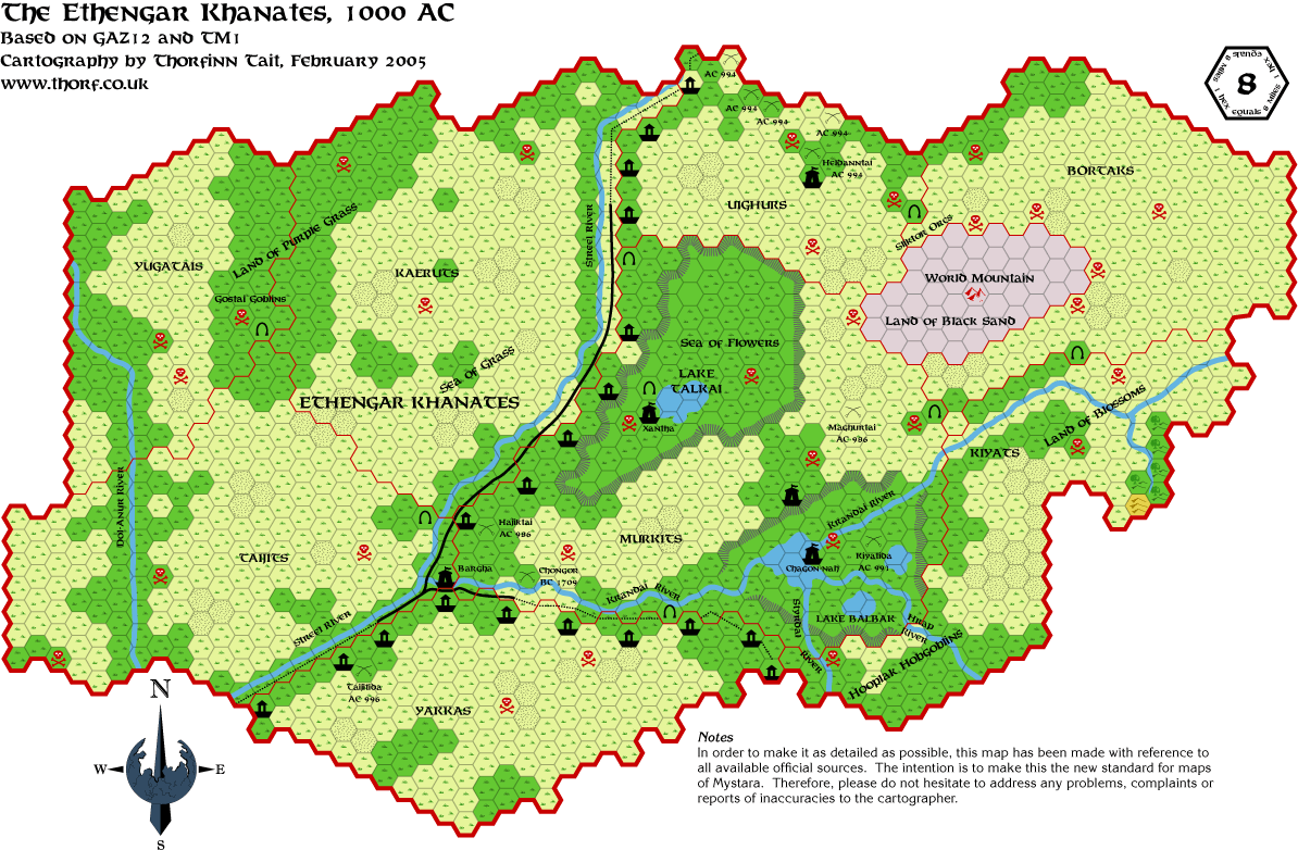
- GAZ14's
map is in the drawing stages, but it has been on hold for a while now.
I want to get X4's Great Waste map completed before continuing, so that
I can use the Expert Set and X4 maps as conversion sources to ensure
the accuracy of the map.
|
Are you planning on doing the 8-mile per hex maps of Sind from Champions of Mystara, or are you just doing the Gazeteer series?
|
26 February 2005, 03:35 AM
|
 |
Member
|
|
Join Date: Jan 2005
Location: Akita, Japan
|
|

Quote:
|
Originally Posted by Joe Mason
Are you planning on doing the 8-mile per hex maps of Sind from Champions of Mystara, or are you just doing the Gazeteer series?
|
Do you mean am I planning to now, or am I planning to at all? 
Eventually I want to map every bit of Mystara covered in the official
books at 8, 24 and 72 miles per hex. If and when that monumental task
is completed, I will then move on to the numerous regions that have
been added by us boardies and listies.
The number of official maps is actually far more limited than you might
think, so naturally I'm starting off by remaking all of them. Once I've
got all of them done, or at least the majority, then I will start
converting and rescaling, using the efforts of the other unofficial
mappers who have come before me as secondary sources. My first
priorities for new 8 mile per hex maps will definitely be Heldann,
Wendar and Sind.
So the short answer is yes, but not quite yet. 
I'm very pleased with how my underground maps are turning out. If you
wait a few days you'll be able to see them for yourself, and with any
luck you'll like them as much as I do. 
|
26 February 2005, 03:52 AM
|
|
Member
|
|
Join Date: Jan 2005
Location: Akita, Japan
|
|
Various replies
Quote:
|
Originally Posted by Cthulhudrew
I've
got quite a few of the hex symbols for Undersea maps in my own Paint
based hex system. If you'd like, you could use them as a template for
your hexes- maybe make the process go a bit quicker. Not sure how well
you can modify .bmp files in Illustrator, though. Let me know if you
want them.
For that matter, I'll see about doing a version of the Undersea map myself, that you can use as a template.
|
What I really need is a scan of the map to trace over, because doing it
visually, while possible, is painstakingly slow and of course the end
product is not nearly so accurate. The symbols aren't really a problem,
they just take a little time to make. Also, making a good palette
probably takes longer, and is definitely harder, than making the
symbols.
Any help will be much appreciated, by the way. Thanks for offering.
BMP files make fine guides in Illustrator, but since they are
rasterimages (which are made of pixels), they can't be used directly.
Illustrator uses vector images made up of paths and anchors, and hence
can be resized without losing quality.
Quote:
|
Originally Posted by DM
Well Thorf, first of all CONGRATULATIONS PAL! for your marriage!
I hadn't quite adjusted myself to the news you were engaged to a
Japanese gal that you already surprise me with the big step , you
devil!
Anyway, I'm curious: where will the ceremony be held? Will your parents
and Mag attend? What kind of ceremony are you planning? What about your
permanent location and job? Where have you scheduled your honeymoon?
When is it all going to happen? And above all... will you hire a
photographer or a mangaka to do your portraits?? |
Hehe, thanks Marco.
The marriage itself is probably going to be not much of an affair,
because unfortunately my fiance's parents are divorced and her family
is not close. However, as you know my family is the opposite, so we're
planning on having a proper ceremony and reception in Orkney next
summer. For various reasons it makes sense to get married this year,
but it's just not possible to arrange an "international wedding" on
such short notice.
We have some definite ideas for the actual ceremony, though... At
Christmas I took her to visit the St. Magnus Cathedral (870 year old
Viking cathedral, for those of you who haven't been yet ), and the chapel there seems perfect.
Where we will live is entirely up in the air too. I really could do
with going back home, at least for a few years, at some point soon. I
need to get some teacher training, and also get my driving license. And
I don't especially want to send my kids to Japanese schools. So
eventually I'm hoping we will move back to Scotland, at least for a
while. But for now, the next few years will definitely be in Akita.
As for the honeymoon... With all these trips home I'm not sure we're going to get one! 
And I think I'll go with the photographer. My dad would not be pleased if I didn't!
Quote:
|
Now on to some frivolous topic, I wanted to warn you about something in
the Darokin map. I remember that the map found in GAZ11 was flawed in
one thing: they had exchanged Mar and Hinmeet's position. Check it out
to see if you got em correctly (haven't got my map here to verify
now)... |
Thanks for the heads up! Can you remember where you read that? Possibly in the Princess Ark series at some point?
Quote:
|
PS: btw, can we know your bride's name?
|
Sure, her name is Kika Mogamiya. Soon to be Kika Tait.
|
26 February 2005, 09:24 AM
|
|
Member
|
|
Join Date: Apr 2004
Location: Long Beach, CA
|
|
The
Hinmeet/Mar thing is definitely from the Dragon articles where Bruce
Heard was answering questions, but I don't recall which issue exactly.
For that matter, some other errata that popped up (for the PWA 1010)
can be found in Dragon #189, IIRC- it pertains directly to the map of
the Isle of Dawn that is supplied in that product, so you might want to
check it out.
|
26 February 2005, 09:51 AM
|
 |
Member
|
|
Join Date: Mar 2004
Location: Ontario, Canada
|
|
Quote:
|
Originally Posted by Cthulhudrew
For
that matter, some other errata that popped up (for the PWA 1010) can be
found in Dragon #189, IIRC- it pertains directly to the map of the Isle
of Dawn that is supplied in that product, so you might want to check it
out.
|
I could be off, but the Isle of Dawn errata sounds familiar and the
Vaults of Pandius is what came to mind when I tried to remember it. If
it's not there, I think it would be good to have it placed in the
errata section of the Vaults (if possible, that is).
|
26 February 2005, 12:32 PM
|
|
Member
|
|
Join Date: Jan 2005
Location: Akita, Japan
|
|
Saturday's Map
Kinda rushed today, but I managed to finish to two maps yesterday!
Here's the second part of GAZ10's maps. I'm rather pleased with the way
it turned out - the palette is nicely subdued, and matches the original
one quite well too.
As of right now, there's one small error in it: the red swirl in the
rightmost lava pool is missing. I actually drew this in very nicely,
but I think I deleted it by mistake when I deleted the guide. I'll add it back in when I get the chance.
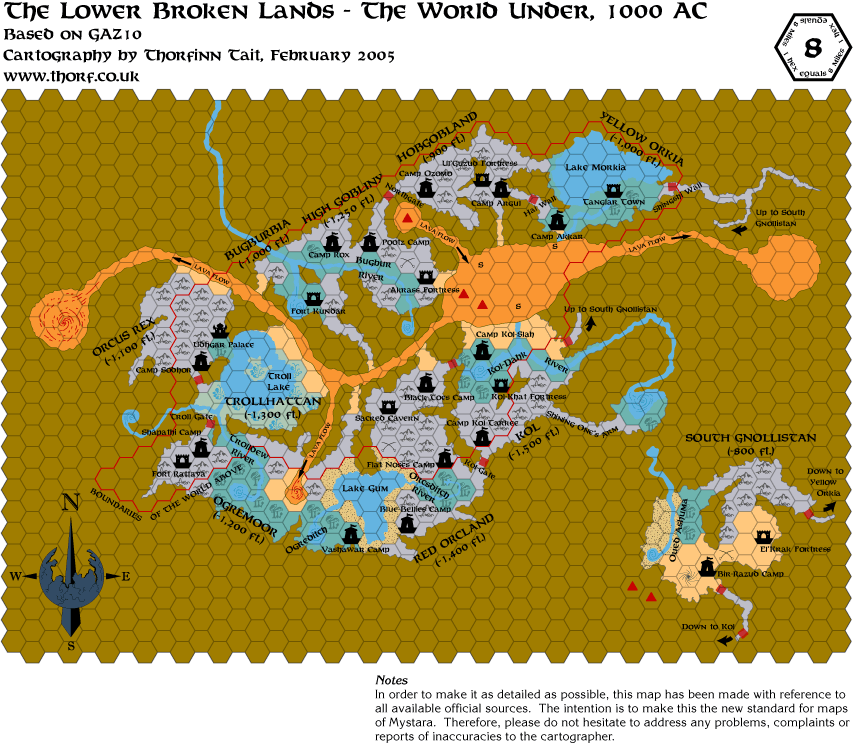
Thanks for the info on errata. I'm going to be converting Darokin's map soon, and I'll fix the Darokin error then.
I do remember the Isle of Dawn errata for the Poor Wizard's Almanac, I'll make sure to refer to it when I get to doing that map.
Edit: I just updated the map file with the corrected lava pool swirl, and I fixed a small colouring error on one hex too.
Last edited by Thorf : Today at 05:47 PM.
Reason: Fixed the map URL
|
27 February 2005, 12:54 AM
|
|
Member
|
|
Join Date: Jan 2005
Location: Akita, Japan
|
|
Slow day on the board
We
tried to go shopping this afternoon, but with the large amount of snow
that unexpectedly fell last night, and what with it being Saturday, it
took forever to get anywhere. We ended up giving up after the first
shop!
Anyway, the good news is that I'm almost finished updating all the maps to the new system now.
I have just uploaded the latest versions of Darokin, as well as both
versions of the Northern Reaches map. As always they have replaced the
older versions of the same maps in this thread.
I made an interesting discovery a few days ago: Illustrator CS files
are fully compatible with Acrobat Reader, which means that you can load
and view them exactly as if they were PDF files. This could have great
benefits for printing, because it's infinitely better to be printing
from the original vector graphics source than from a
rendered/rasterized BMP or PNG. The only problem is that the map files
themselves are a little too big to post on my website.
|
27 February 2005, 02:29 AM
|
 |
Member
|
|
Join Date: Mar 2004
Location: Stockholm, Sweden. For a while.
|
|
Wow, Thorf. The Underground map is truly wonderful and actually inspiring. Thanks!
|
27 February 2005, 01:46 PM
|
|
Member
|
|
Join Date: Jan 2005
Location: Akita, Japan
|
|
Sunday's map
Not much to say about this one, really. I am considering changing the few forested hills hexes to evergreen.
|
28 February 2005, 02:28 PM
|
|
Member
|
|
Join Date: Jan 2005
Location: Akita, Japan
|
|
 Monday's map
Today's
map is the Shadow Elf Territories. This map looked like it would be
easier than the Broken Lands underground map, because of the lack of
cavern walls. But actually the complexity of the map, and the abundance
of labels, made it take about the same time to make, I think.
This was always one of my favourite maps, and it's easy to see why:
almost every section of the map has its own label, and there are so
many locations for adventures just waiting to be used. Also, it
revealed a whole new world existing right below the world we had all
come to know.
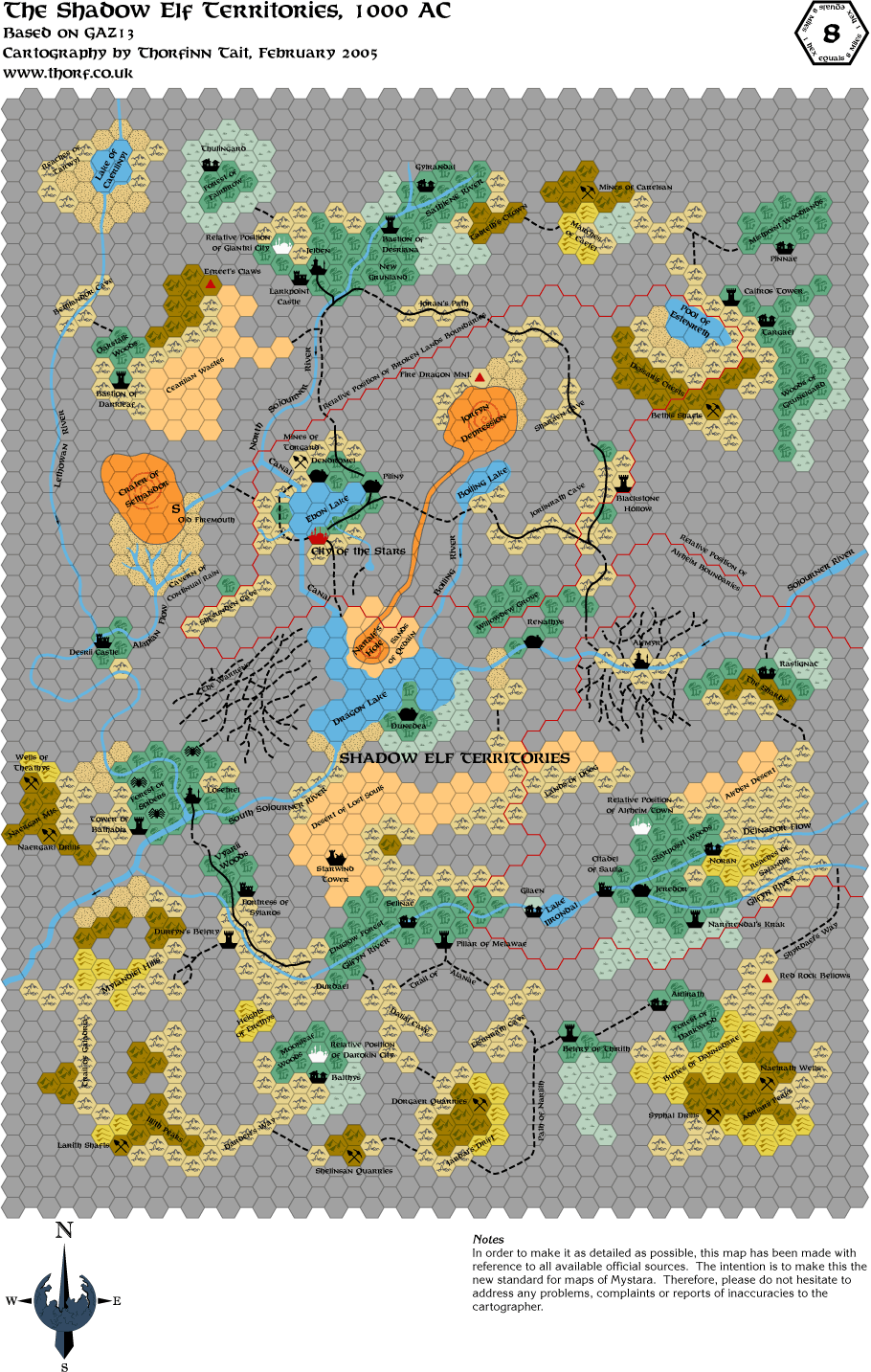
One last thing for today - I'm considering raising the quality of the
maps I post. At the current size, the detail of deserts disappears
completely, and heavy forests look a little strange too. I usually work
with them at 150% zoom in Illustrator, but what does everyone think?
The file size will increase, as will the pixel size, but the maps do
look much better at 150%.
|
28 February 2005, 02:52 PM
|
|
Member
|
|
Join Date: Apr 2004
Location: Long Beach, CA
|
|
I
really like the Shadow Elf map, too, for many of the reasons you state-
since there wasn't much detail given in Gaz13, there's a lot of
fleshing out begging to be done, and the map gives a lot of
hints/suggestions to do so.
The only things that bugged me about it were the lack of cavern walls,
a la the Broken Lands map, and the Mountain hexes on the map. By
Gaz13's description, there aren't any caverns that should be large
enough to host *a* mountain, much less mountain ranges.
|
28 February 2005, 10:18 PM
|
|
Member
|
|
Join Date: Jan 2005
Location: Akita, Japan
|
|
Unexplained labels can be great adventure hooks for a DM, and it gives the map real character too.
I'm definitely going to have a go at adding cavern walls on to that map
when I have time. It would look really great with them. As for the
mountains, I hadn't thought of that. Unfortunately they're a very big
feature of the map...
Another thing I've considered doing is adapting the colour scheme to be more like GAZ10...
Today I did X4's Great Waste map, and had a little try at joining it up
with the Expert Set map. It's extremely simple compared to the later
maps, of course, but some of the basic terrain shapes are already
intact. Most importantly, the Atruaghin plateau can be seen in its
entirety. I'm looking forward to having my own try at fixing GAZ14's
map when I get the time. It'll be interesting to see what I come up
with, and I'm looking forward to comparing it with your map, Andrew,
and eventually producing a hybrid probably.
|
28 February 2005, 11:07 PM
|
|
Member
|
|
Join Date: Mar 2004
Location: Stockholm, Sweden. For a while.
|
|
By the way - shouldn't the City of the Stars icon be up-side-down?
|
28 February 2005, 11:35 PM
|
 |
Member
|
|
|
|
Thorf- These look fantastic!
I'm all for increasing the size and quality of the maps if you don't
mind taking the time to update all the images you've posted.
Thanks again for you're hard work!
|
1 March 2005, 10:47 AM
|
 |
Member
|
|
Join Date: May 2004
Location: Bothell, WA
|
|
Quote:
|
Originally Posted by Thorf
Wow, thanks a lot! It would be great if they were impressed enough to consider printing more Mystara articles. |
Workin' on it. In the meantime, keep up the great work with these.
They almost made me want to DM again (in the Known World, of course). Almost.
Oh, hey, congrats on getting hitched! I wish you only the best.
__________________
Mike McArtor
Associate Editor
Dragon Magazine
...
Opinions expressed are my own and do not represent Dragon, Paizo Publishing, or Wizards of the Coast.
|
1 March 2005, 06:04 PM
|
|
Member
|
|
Join Date: Jan 2005
Location: Akita, Japan
|
|
Quote:
|
Originally Posted by Lost Woodrake
By the way - shouldn't the City of the Stars icon be up-side-down?
|
Funny thing, that - they put it the right way up on the 8 mile per hex map, and upside down on the 2 mile per hex map.
To be honest, I think they goofed up a bit with the maps for that
cavern. The cavern has two floors, so there should really be two maps,
one for the "floor" and one for the "ceiling". I always wondered why
the roads seem to lead to the city, even though it's actually far
above, on the roof!
Quote:
|
Originally Posted by Traianus Decius Aureus
Thorf- These look fantastic!
I'm all for increasing the size and quality of the maps if you don't
mind taking the time to update all the images you've posted.
|
It won't take much time at all to export them all again at a slightly
higher resolution. I think I'll try it out on a couple of maps and let
you see the difference yourselves.
Quote:
|
Originally Posted by MKMcArtor
Workin' on it. In the meantime, keep up the great work with these.
They almost made me want to DM again (in the Known World, of course). Almost.
Oh, hey, congrats on getting hitched! I wish you only the best. |
Thanks! I'm really glad my maps seem to be going down so well.
|
1 March 2005, 06:20 PM
|
|
Member
|
|
Join Date: Jan 2005
Location: Akita, Japan
|
|
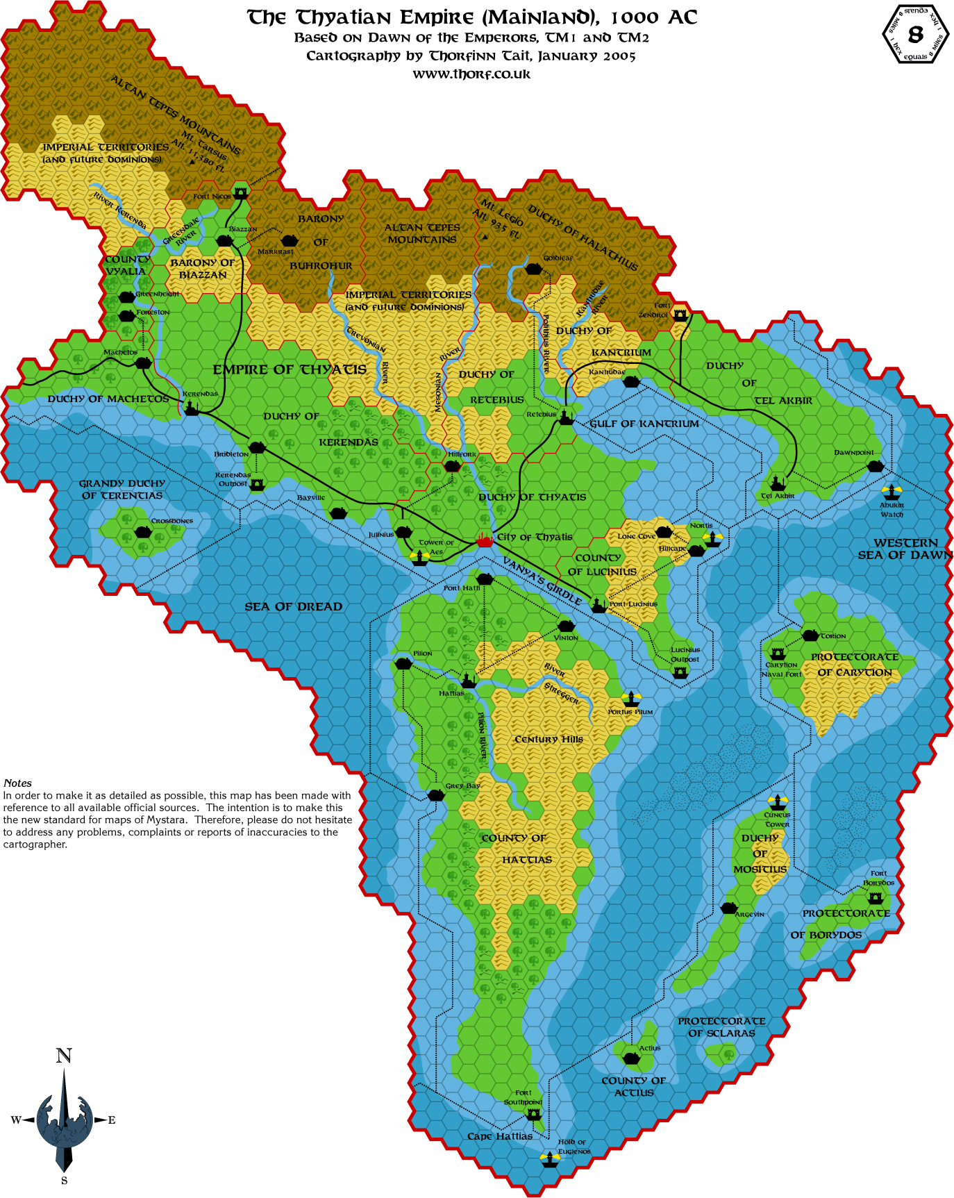
Tuesday's Map
Here's
Tuesday's map - mainland Thyatis. As a little experiment, I'm
presenting it to you at a size of 125% compared to the previous maps. I
have also updated the Ylaruam map to that size, and now it's possible to see the detail on the desert hexes. Please tell me what you think!
|
2 March 2005, 03:52 AM
|
|
Member
|
|
Join Date: Jan 2005
Location: Akita, Japan
|
|
Mapping Update
I
spent the evening tonight playing about with the Atruaghin plateau and
a new 24 mile per hex Known World map based on the 8 mile per hex maps.
In doing so I noticed yet more errors in the 24 mile per hex maps.
It seems to me that the reason the 24 mile per hex maps we have are so
inaccurate is that really the Expert Set map was the only one of that
area in that scale for almost ten years. Amazingly, the next map to be
released was the one included in Wrath of the Immortals, meaning that
there is in fact no official 24 mile per hex map of the Known World in
AC 1000. Or at least, none that are properly in synch with the
Gazetteers, because of course the Expert Set map was changed as they
made the 8 mile per hex maps.
The only other 24 mile per hex maps I could think of are the Champions
of Mystara Great Waste map, which shows the edge of the Known World,
and the AD&D Mystara map. Both of these seem to copy closely from
Wrath's map, mistakes and all.
This is no big problem, because it's not that hard to scale up a map.
I'm almost finished the initial work on my new 24 mile per hex AC 1000
map, but the next step is to revise it using the Wrath of the Immortals
map, incorporating all the best parts of it and none of the errors.
One big problem, though, is that there are three versions of the
Atruaghin plateau to choose from. The Wrath of the Immortals and
Champions of Mystara versions are almost the same, but the original
Expert Set/X4 plateau is actually significantly different, including at
least two extra hexes. And I haven't even mentioned the Dawn of the
Emperors 72 mile per hex plateau... 
In the end I'll probably go with the Wrath of the Immortals/Champions
of Mystara one, because it appears to be the most compatible with
GAZ14, requiring the least drastic fixing. Andrew, which did you go
with?
Edit: I'm considering changing my palette a little to give better
colours for printing. The current one is I believe a nice compromise
between the subdued colours of printed maps and the wild colours of
many screen maps, but from my thus-far limited trials, it doesn't seem
to print very well... Any thoughts? Would a more subdued palette be
better than the current one?
Last edited by Thorf : 03-02-05 at 03:56 AM.
Reason: Added note on palette changes
|
2 March 2005, 10:16 AM
|
|
Member
|
|
Join Date: Apr 2004
Location: Long Beach, CA
|
|
Quote:
|
Originally Posted by Thorf
It
seems to me that the reason the 24 mile per hex maps we have are so
inaccurate is that really the Expert Set map was the only one of that
area in that scale for almost ten years.
|
The X4/X5/X6/X9 and X11 maps all fit with the 24 m/hex map from the
Expert set. The CM series maps, I think you'll find, were probably
intended to be in 36 m/hex scale, though they say 24/hex.
Quote:
|
The only other 24 mile per hex maps I could think of are the Champions
of Mystara Great Waste map, which shows the edge of the Known World,
and the AD&D Mystara map. Both of these seem to copy closely from
Wrath's map, mistakes and all. |
The Sind portion of the Champions of Mystara map actually preceded
Wrath of the Immortals- it was included (at 24/hex scale) in the
Princess Ark article on Sind (c.169) and came out quite a ways before
Wrath of the Immortals. I think it fits with the Expert/X4 maps, IIRC,
at least largely- well, aside from the sudden introduction of several
nations where previously we'd had only some small villages.
The portion of Yavdlom that we have came from before Wrath, as well.
Champions of Mystara came out after Wrath, with its expanded additions
(notably the Great Waste and Slagovich). As you note, I don't think the
Savage Coastal 8 mile maps we have quite fit with the 24 scale.
Quote:
|
In the end I'll probably go with the Wrath of the Immortals/Champions
of Mystara one, because it appears to be the most compatible with
GAZ14, requiring the least drastic fixing. Andrew, which did you go
with? |
Don't recall- I think what I ended up with was a mishmash of several.
You have probably noted that the portion of the plateau in the Trail
map doesn't match up precisely with the version given in Gaz14 either.
What I did, IIRC, was start with the Gaz14 version (giving me the 8
mile/hex version), then extrapolated what the plateau *should* look
like around it, using the Expert/CoM versions of the plateau as a
template. I tried to keep as many features of the 8 mile version as
possible, so that the outer areas of the plateau might not precisely
match the 24 mile versions, but it was close enough that I attributed
the difference to scaling. I hadn't really noticed the Expert change
until you mentioned it, though, but I think that was on the end that I
changed the least (the portion on the trail maps- the eastern end), so
it didn't affect my alterations.
Ultimately, what I found, was that the outer portions of the plateau in
Gaz14 more or less match the 24 mile/hex versions (with some very
slight changes needed), but that somehow a whole chunk of the middle of
the plateau is what got chopped out.
|
2 March 2005, 02:18 PM
|
|
Member
|
|
Join Date: Jan 2005
Location: Akita, Japan
|
|
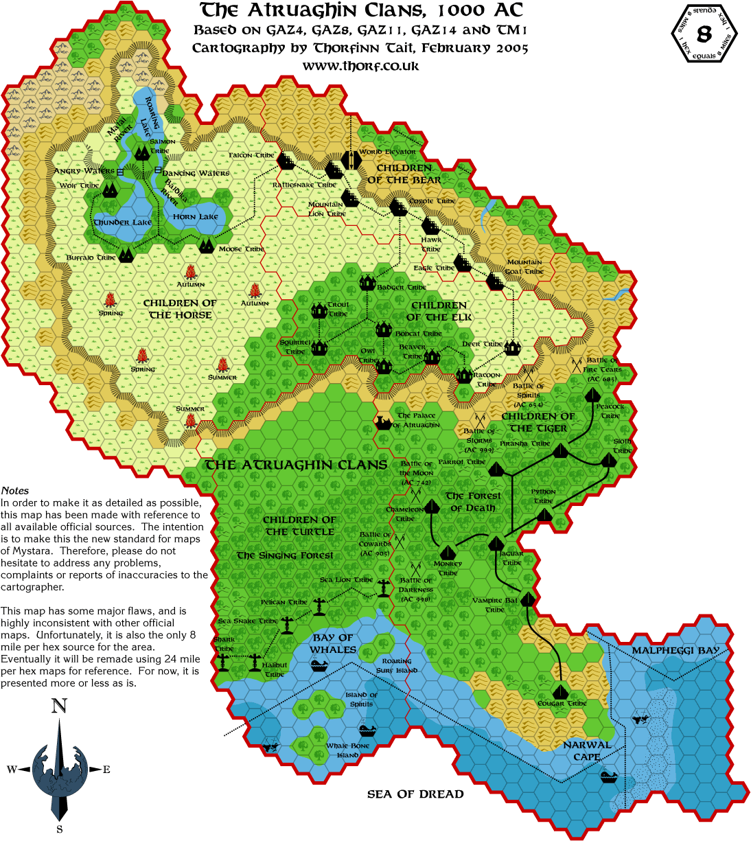
 The Atraughin Question
Quote:
|
Originally Posted by Cthulhudrew
The
X4/X5/X6/X9 and X11 maps all fit with the 24 m/hex map from the Expert
set. The CM series maps, I think you'll find, were probably intended to
be in 36 m/hex scale, though they say 24/hex.
|
Yes, the X series maps all fit together, but what I meant was that they
don't develop one area, rather they simply add more areas onto the
edges. And don't forget that putting the maps together is also far from
simple.
I've been grappling with attaching X4's Great Waste map to the Expert
Set map for a couple of days now, but there just doesn't seem to be a
logical way to do it that agrees with the later maps. If you join them
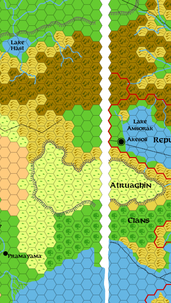
up based on the plains area bordering Akesoli, you end up with a one
hex gap between the two maps. Both maps end with partial hexes on the
edges, but it's hard to see how you could consider the extremely
marginal hexes of the Expert Set map's western border as "mapped",
because all you can see is the white corners.
Quote:
|
The Sind portion of the Champions of Mystara map actually preceded
Wrath of the Immortals- it was included (at 24/hex scale) in the
Princess Ark article on Sind (c.169) and came out quite a ways before
Wrath of the Immortals. I think it fits with the Expert/X4 maps, IIRC,
at least largely- well, aside from the sudden introduction of several
nations where previously we'd had only some small villages.
|
Oops, I forgot about that map. You're right, it's the first development
of that area since X4. But "largely" would be the operative word. There are some definite changes to the lay of the land, as well as a couple of outright mistakes.
The interesting thing is that this map decided how the Expert Set and
X4 maps fit together, and all the following maps went along with
it.
Quote:
|
Champions of Mystara came out after Wrath, with its expanded additions
(notably the Great Waste and Slagovich). As you note, I don't think the
Savage Coastal 8 mile maps we have quite fit with the 24 scale. |
I'd be getting ahead of myself to start talking about this now too, so I'll respectfully leave this discussion until later. 
Quote:
|
Don't recall- I think what I ended up with was a mishmash of several.
You have probably noted that the portion of the plateau in the Trail
map doesn't match up precisely with the version given in Gaz14 either. |
Yeah but the trail map version of Atruaghin is just one of those rough
mock ups they made for the surrounding countries while they were making
the Gazetteers, right? I don't think I'd place much faith in that
particular source. It's such a small area, too.
In any case, a mishmash seems like probably the best solution, I agree.
Quote:
What I did, IIRC, was start with the Gaz14 version (giving me the 8
mile/hex version), then extrapolated what the plateau *should* look
like around it, using the Expert/CoM versions of the plateau as a
template. I tried to keep as many features of the 8 mile version as
possible, so that the outer areas of the plateau might not precisely
match the 24 mile versions, but it was close enough that I attributed
the difference to scaling. I hadn't really noticed the Expert change
until you mentioned it, though, but I think that was on the end that I
changed the least (the portion on the trail maps- the eastern end), so
it didn't affect my alterations.
Ultimately, what I found, was that the outer portions of the plateau in
Gaz14 more or less match the 24 mile/hex versions (with some very
slight changes needed), but that somehow a whole chunk of the middle of
the plateau is what got chopped out. |
Yes, I agree. The general shape seems to be not too bad, and roughly
follows the original outlines given in the Expert Set, X4, Dragon 169,
etc. With a few exceptions, of course. But as you say they appear to
have missed out a large section in the middle. It's all kinda strange.
I'm still convinced that they did it deliberately just to fit it on
their map sheet!
One point about converting scales, by the way. The problem with scaling
up is that we have some features that get severely simplified, such as
terrain types (hexes), but other features stay exactly the same and
just get shrunk, for example coasts, rivers, etc. The general rule
seems to be that if it isn't a hex, or doesn't follow the hex grid, it
just gets shrunk.
What this means is that the Atruaghin plateau depicted on the 24 mile
per hex maps needn't follow the hex grid too faithfully on the 8 mile
per hex map. The same could be said of the Ylaruam plateau. In the end
the map would probably look better with a plateau that has a less
hex-based border.
I'm considering having a go at doing this, basing the new border on
existing 24 mile per hex maps, while referring to the 8 mile per hex
map for detail. After creating the border at 8 miles per hex scale, I
could then very easily reduce it in size for the 24 mile per hex scale,
losing no detail at all.
I guess in the end this all comes down to the question of exactly how hexy you want your maps to be.
In the meantime, here is today's map. It's GAZ14's Atruaghin, with the
southeastern borders adjusted to fit with GAZ4 and GAZ8. Otherwise it
has all flaws intact for now.
Last edited by Thorf : Today at 05:47 PM.
Reason: Fixed the map URL
|
2 March 2005, 08:52 PM
|
|
Member
|
|
Join Date: Jan 2005
Location: Akita, Japan
|
|
Lamenting the errors of mapmakers past
I
just finished recreating X5's map of Hule. Why am I not surprised that
it doesn't agree at all with the adjoining edge of X4's map? 
Oh well, at least this time it does have a definite, confirmable
overlap area. But getting those rivers to line up when they clearly
weren't designed to line up in the first place is going to be
difficult. 
It'll be interesting to see how/if the existing official maps of the
area deal with this problem. I think the offending area is featured on
Champions of Mystara's Great Waste map, and possibly in one of the
Princess Ark maps too.
...
Well, a preliminary comparison shows that Champions of Mystara's map
generally goes with the X5 version of the overlapping area. Moreover,
it looks as if they really did their research pretty well when making
the new Great Waste map, because it retains almost all the basic
terrain features (generally mountains, hills, lakes) while sorting out
the problem with the rivers.
One disturbing point, though, is that the edge of Darkwood appears on
the map, whereas according to X5's map, it should be just off the edge
of the new map. And unfortunately X5 is the only primary source we have
for Hule... isn't it?
|
2 March 2005, 09:50 PM
|
|
Member
|
|
Join Date: Apr 2004
Location: Long Beach, CA
|
|
Quote:
|
Originally Posted by Thorf
I
just finished recreating X5's map of Hule. Why am I not surprised that
it doesn't agree at all with the adjoining edge of X4's map?
|
Worse yet, they went with two completely different styles of mapping.
Actually, I haven't looked at X5's map in quite some time- I really
like the style they used on that map.
Quote:
|
Oh well, at least this time it does have a definite, confirmable
overlap area. But getting those rivers to line up when they clearly
weren't designed to line up in the first place is going to be
difficult. |
I'm looking at my X-series maps right now- not sure, but it looks like
using X6's map might help to join the two maps, at least at the
"bottom". Still won't quite help the terrain features (like the Black
Mountains), but at least it might help to line them up properly.
[EDIT] Still looking and- you may have noticed this- but it looks like
you should "discount" the furthest left row of hexes (the incomplete
row) as far as the terrain marked, and just go with what the X5 map has
from that row east- the two maps join and match up pretty well at the
bottom-most three mountain hexes. There are a few terrain differences
in the northeast of the X5 map, but for the most part, the only big
problem is that last row on X4.
Quote:
|
One disturbing point, though, is that the edge of Darkwood appears on
the map, whereas according to X5's map, it should be just off the edge
of the new map. And unfortunately X5 is the only primary source we have
for Hule... isn't it? |
You're right- it looks like the Dark Wood has been steadily creeping eastwards since X5 was published...
Bad news- X5 is, to my knowledge, the only map of Hule that we have.
Good news- From my own mapping efforts (at least as far as I can
recall) the cartography of the Savage Coast is much more consistent
with the maps of the region that we do have. The X-series maps really
do fit with the 8 mile maps of the same regions as set forth in the
Princess Ark series. There is some slight discrepancy with scaling in
the City-States area, though.
Actually, come to think of it, the Yavdlom 8 mile map we have doesn't
fit well at all with the 24 mile version as I'm sure you'll soon
discover for yourself.
[Final Edit] It looks like one of the tributaries of the river in the
Burning Waste also disappeared between X6 and CoM. Of course, given the
retroactive timeline, there have been quite a few centuries...
But the Savage Coast was done very well.
Last edited by Cthulhudrew : 03-02-05 at 10:14 PM.
|
2 March 2005, 09:53 PM
|
|
Member
|
|
Join Date: Apr 2004
Location: Long Beach, CA
|
|
Quote:
|
Originally Posted by Thorf
Oh
well, at least this time it does have a definite, confirmable overlap
area. But getting those rivers to line up when they clearly weren't
designed to line up in the first place is going to be difficult.
|
Still going over my X-maps, and darned if I never noticed before that
X4 has a river right near the Great Pass, while X5 doesn't.
Chalk it up to misinformation by the Hulean Ministry.
(Now that I think of it, that's probably not a bad idea. We should
maybe look at the X4 map as based on the Republic's incomplete
information of the west, and the X5 map as the 'official' state version
of Hule.)
|
2 March 2005, 09:56 PM
|
|
Member
|
|
Join Date: Apr 2004
Location: Long Beach, CA
|
|
Another
interesting point that I hadn't seen before, but that I'll be
incorporating into my Sind maps- the X4 map has the outlet of the
Asanda into the Sea of Dread as a delta, while the CoM map simply has
the river widen out. I think I actually prefer the delta version. It
will give that region a bit more character in an 8 mile/hex scale than
just widening the mouth would.
|
3 March 2005, 01:54 PM
|
 |
UnCon Prizewinner
|
|
Join Date: Mar 2005
Location: USA
|
|
Thorf: The Vaults of Pandius might be able to host your source files, depending on how big they are (use compression maybe?).
I am glad that you've posted the methods you use for mapmaking; I was
going to start doing some non-canon Savage Coast maps soon (an animated
gif or png with the rise and fall of the different Baronies), and your
suggestions will help immensly. Any chance you could at least post the
original SVG/PS file with the hex outlines and the SVG/PS file with the
Terrain Legend?
Oh, while I'm thinking vector graphics, there's an opensource program
that touts that it can convert a bmp to a vector graphic format
somehow: http://autotrace.sourceforge.net/
|
3 March 2005, 08:17 PM
|
|
Member
|
|
Join Date: Apr 2004
Location: Long Beach, CA
|
|
Thorf, I've got a question that just occurred to me while looking at your Thyatis map.
What are your feelings on the Rugalov Keep/Blackpoint Citadel issue?
Rugalov is visible on the map in the hex on the other side of the river
Rugalov in Karameikos (opposite the village), and is the only keep
visible on the Trail Map. Blackpoint Citadel was added on the Thyatian
map, and placed (for whatever reason) in the exact same hex as Rugalov
Keep. The description of Blackpoint has it that it sits directly across
from Rugalov, so they are probably very close together (perhaps within
the distance of an 8 mile hex), but it doesn't work out too well on
that scale map.
Should Blackpoint be placed on the opposite side of the border from Rugalov (in the hex directly southeast of it)?
Frankly, I"m not sure why the cartographer didn't (in retrospect)
replace Rugalov Village's icon with the Keep symbol and let us presume
that the Keep and Village were both close together on the western side
of the River, and put Blackpoint on the eastern side. I guess that
Rugalov is supposed to be the first line of defense to keep invaders
from crossing at the river, though. Having trouble picturing how
thesetup would look with two Keeps on (seemingly) flat, open terrain
within a couple of miles of one another...
|
|
|