Thorf's Secret Project: Stage One
A recreation of the Mystara Message Board thread that started the Atlas of Mystara project, with restored links and images.

6 Sep 2020, 07:00 PM
|
 |
Member |
|
Join Date: Jan 2005
Location: Akita, Japan
|
|
 Thorf's Secret Project: Stage One (Now Fully Indexed!)
Welcome to the original message board thread that kicked off my "secret project", the Atlas of Mystara.
I began work in earnest in January 2005, then teased the project on Wizards of the Coast's Mystara Message Board in early February, presenting it as "Thorf's Secret Project". First I previewed my hex art, then I started this thread and began posting maps daily, which continued with just a few breaks from mid February until June. The stated aim of "Stage One" was a comprehensive effort to map the world of Mystara, inside and out. The true scope of the project was not revealed until 2008, by which point the main venue for mapping work had moved to the Geographical Mapping forum at the newly-founded Piazza.
Aside from rewriting this introductory post, the thread remains as it was first written, without editing. 2005 was a period of great events in my life, and this too is reflected in the posts here.
The maps have been restored as best I can, fixing broken links and presenting archival versions wherever possible. Note however that many of the very earliest versions have been lost, as they were incrementally replaced by revised versions a great number of times during the first few months of the project. I have included the date of each map in its filename to make this clear; the most common case is that the earliest version available dates from June 2005, but I was able to find at least a few from the first month of the project.
The index below, which Shughuy originally helped create to present all the maps, has been adapted to present and document as many old versions as I could find, sorted by date.
Atlas users will likely already be familiar with my concept of "updated" and "replica" maps; you can actually see this idea evolving here, as my initial conception wasn't nearly so clear cut. You can also see that I originally intended to work through things chronologically, although this idea got lost somewhat until it re-emerged many years later as the Let's Map Mystara project.
In case you are not familiar: Replicas are accurate recreations of existing maps, including any errors. Updated maps are my own interpretation of all the available sources, fixing errors and consistency to create a new super-accurate set of Mystaran maps. These latter maps form the core of the Atlas of Mystara.
 Map Archive Index Map Archive Index
Key: Archived old map link  Atlas of Mystara link
 Legends Legends
- Legend Feb 2005,
Jan 2006,
Feb 2006
- Legend: Underground Apr 2006,
Apr 2013
- Legend: Undersea Jun 2005
Updated Maps: 8 miles per hex (25)
- Aengmor, 1010 AC Feb 2005, Jun 2005
- Alfheim, 1000 AC Feb 2005, Jun 2005,
Latest
- Atruaghin Clans, 1000 AC Mar 2005, Jun 2005,
Latest
- Upper Broken Lands, 1000 AC Jun 2005,
Latest
- Lower Broken Lands, 1000 AC Jun 2005,
Latest
- Darokin, 1000 AC Jun 2005,
Latest
- Ethengar, 1000 AC Jun 2005,
Latest
- Five Shires, 1000 AC Jun 2005,
Latest
- Glantri, 1000 AC Feb 2005, Jun 2005,
Latest
also variants: Deciduous 17 Feb 2005, 22 Feb 2005,
- Gulf of Hule, 1000 AC Jun 2005,
Feb 2006,
Apr 2006,
Jun 2008,
Aug 2008,
Latest
- Herath, Shazak, Ator and Cay, 1000 AC Feb 2006,
Aug 2008
- Ierendi, 1000 AC Feb 2005, Jun 2005,
Latest
- Isle of Dawn, Western Region, 1000 AC Jun 2005
- Karameikos Feb 2005, Jun 2005,
Aug 2008,
Latest
also variants: Forested Hills Jun 2005,
Normal Hills Feb 2005,
Shaded Forests Feb 2005
- Minrothad, 1000 AC Feb 2005, Jun 2005,
Jan 2016,
Latest
- Nithia, 1000 AC Jun 2005,
Jun 2005,
Jun 2008,
Nov 2015,
Feb 2018
- Northern Reaches, 1000 AC 21 Feb 2005, 26 Feb 2005,
Jan 2006,
Feb 2006,
Jul 2008,
Mar 2016,
Latest
- Orc's Head Peninsula, 1000 AC Feb 2007
- Rockhome, 1000 AC Feb 2005,
Jun 2005,
Jan 2016,
Latest
- Savage Baronies, 1000 AC Feb 2006,
Apr 2006
- Savage Coast, Central Region Jun 2005,
Mar 2006,
Jul 2008,
Aug 2008,
Latest
- Shadowlands Mar 2005,
Mar 2005,
Apr 2006,
Jul 2008,
May 2009,
Apr 2013,
Feb 2016,
Latest
- Southern Hule and the City States, 1000 AC Feb 2006,
Latest
- Thyatis, 1000 AC Mar 2005, Jun 2005,
Mar 2009,
Jan 2016,
Latest
- Ylaruam, 1000 AC Feb 2005, Jun 2005,
Aug 2008,
Mar 2009,
Mar 2009,
Latest
Updated Maps: 24 miles per hex (5)
- Alatian Islands, Pearl Islands and Ochalea, 1000 AC
- Alphatia, 1000 AC; also deciduous forest version
- Arm of the Immortals and Orc's Head Peninsula, 1000 AC
- Great Waste, 1000 AC
- Serpent Peninsula, 1000 AC
Updated Maps: 40 miles per hex (2)
- Iciria, 1000 AC
- Northern Iciria, 1004 AC
Replica Maps: 8 miles per hex (23)
- Atruaghin Clans from GAZ14 (filename changed)
- Slagovich and the City States from Dragon 171
- Southern Hule from Dragon 172
- The Savage Baronies from Dragon 174
- The Savage Baronies from Dragon 175
- The Savage Baronies from Dragon 176
- Robrenn from Dragon 177
- Eusdria from Dragon 178
- Renardy from Dragon 179
- Bellayne from Dragon 180
- Eastern Herath from Dragon 183
- Shazak, Ator and Cay from Dragon 185
- Wallara from Dragon 186
- Jibaru from Dragon 188
- Nimmur from Dragon 192
- Black Orchid Tribe Lands from Dragon 196
- Shadow Elf Territories from GAZ13
- The Sea of Dread Submerged Lands from PC3
 New! 24th June New! 24th June
- Western Isle of Dawn from TM2
- Azcan Empire, 1000 AC from HWR1 New! 4th July
- Southern Kingdom, Kingdom of Nithia from HWR2 New! 21st June
- Delta Kingdom, Kingdom of Nithia from HWR2 New! 22nd June
- Milenian Empire, 1000 AC from HWR3 New! 6th July
Replica Maps: 24 miles per hex (19)
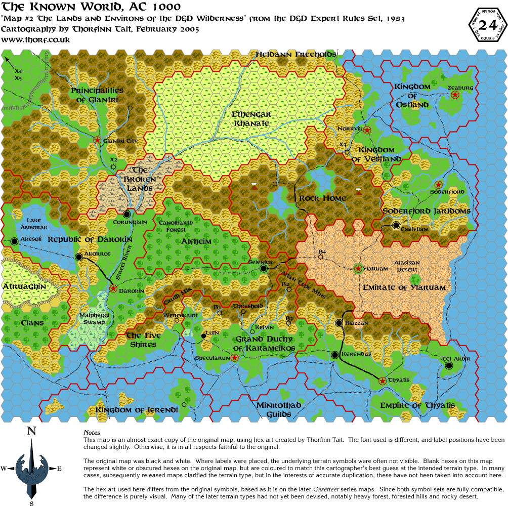
- Expert Set Known World, 1000 AC Feb 2005,
Jan 2006,
Apr 2006,
Jul 2008,
Feb 2013,
Apr 2018,
Latest
- Known World from X1, with the Expert Set and X3
- Great Waste from X4
- Hule from X5
- Wendar and Denagoth from X11
- cm1-m2-Norwold from CM1 and M2
- dawn-Alatian Islands from Dawn of the Emperors
- Alphatia from Dawn of the Emperors
- Isle of Dawn from Dawn of the Emperors
- Ochalea and Pearl Islands from Dawn of the Emperors
- Sind from Dragon 169
- Orc's Head Peninsula from Dragon 196
- Arm of the Immortals from Dragon 200
- Known World from the Rules Cyclopedia
- Known World, 1004 AC from Wrath of the Immortals (original palette version)
- Known World, 1004 AC from Wrath of the Immortals
- Known World, 1010 AC from Wrath of the Immortals
- Great Waste from Champions of Mystara Updated 18th June
- Serpent Peninsula from Champions of Mystara
Replica Maps: 40 miles per hex (3)
- Northern Iciria from the Hollow World Set
- Southern Iciria from the Hollow World Set
- Alphatian Neatharum from Wrath of the Immortals
Replica Maps: non-hex (1)
- Mystara from the Master Set
Other Maps (3)
- Azcan Empire 40 mi per hex map with 8 mi per hex map overlaid
- Milenian Empire 40 mi per hex map with 8 mi per hex map overlaid
- Nithia 40 mi per hex map with 8 mi per hex map overlaid
|
15 February 2005, 12:00 AM
|
|
Member
|
|
Join Date: Jan 2005
Location: Akita, Japan
|
|
Introduction (Note: This was the original first post of the thread.)
I've kept you waiting for almost a week, but finally the time has come.
Starting today, I will be releasing one map (sometimes more!) every day
in this thread. 
Last week I revealed to you that my secret project involved maps. Now
you will start to see some of these maps. The maps themselves are not
my secret project per se, but they do constitute a major part of it. 
First up, here is the full Legend for using with all of my maps. I
decided that it makes more sense to keep it as a separate image, to
save bandwidth. Besides, you all know what the hexes mean anyway. 

Now that that's out of the way, here is the first map. I've been
wondering for a while which I want to post first, and I decided to go
with tradition, and give you one from the very start.
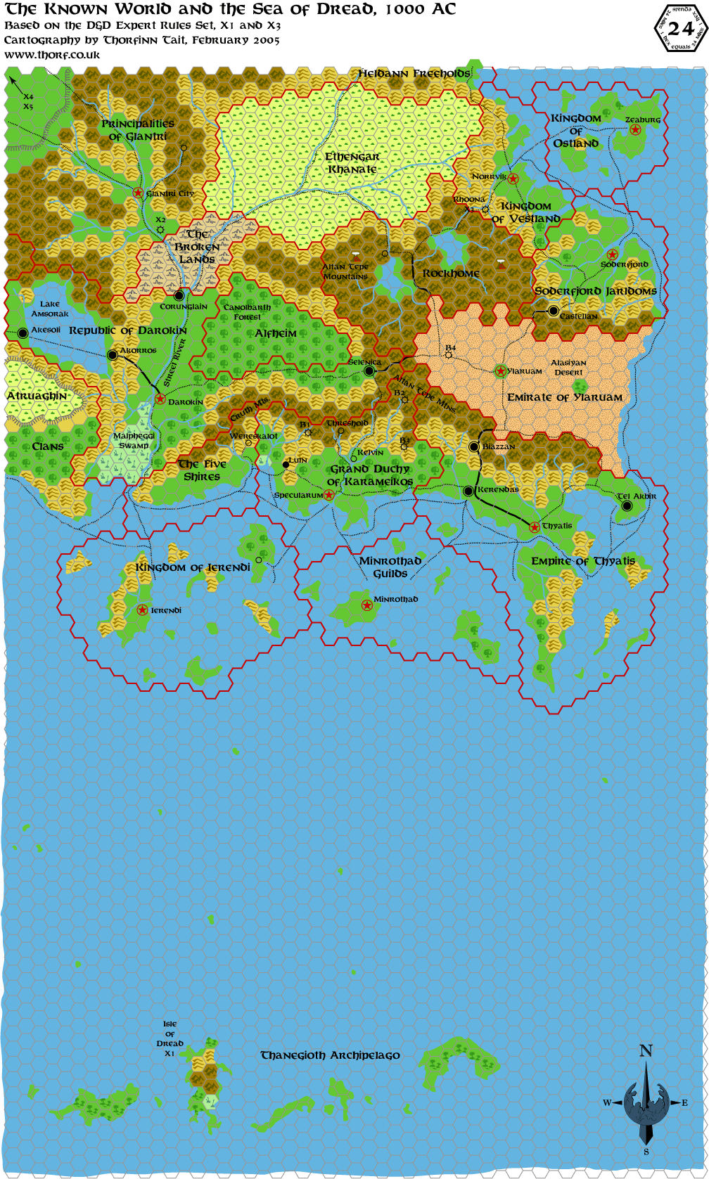 Notes
Notes
This map is based on the original Expert Set map, with additions from X1
and X3. As such, it's a largely undeveloped form of the world,
before it came to be as we know it today. It's an almost exact copy of
the original map, using the hex art I created. The font used (Baldur)
is different, and label positions have been changed slightly.
Otherwise, it is in all respects faithful to the original.
The original map was black and white. Where labels were placed, the
underlying terrain symbols were often not visible. Blank hexes on this
map represent white or obscured hexes on the original map, but are coloured
to match this cartographer's best guess at the intended terrain type.
In many cases, subsequently released maps clarified the terrain type, but in
the interests of accurate duplication, these have not been taken into
account here.
The hex art used here differs from the original symbols, based as it is
on the later Gazetteer series maps. Since both symbol sets are fully
compatible, the difference is purely visual. Many of the later terrain types had
not yet been devised, notably heavy forest, forested hills and rocky
desert.
|
|
|
 |
Member |
|
Join Date: Jun 2003
Location: Liverpool, England
|
|
Very Nice!!
Look forward to seeing more...
Gary
|
15 February 2005, 04:23 AM
|
|
Community Assistant
|
|
Join Date: Mar 2001
Location: canberra
|
|
Quote:
|
Originally Posted by Thorf
Last
week I revealed to you that my secret project involved maps. Now you
will start to see some of these maps. The maps themselves are not my
secret project per se, but they do constitute a major part of it. |
cool, and this isn't even the real project yet __________________
shawn
Vaults of Pandius
http://pandius.com
|
15 February 2005, 04:53 AM
|
|
Member
|
|
Join Date: Mar 2001
Location: Italy
|
|
Very nice map! Your hexes look really good, and the map itself is quite clear and well drawn.
GP
|
15 February 2005, 09:55 AM
|
 |
Member
|
|
Join Date: Mar 2004
Location: Ontario, Canada
|
|
Fantastic job there, Thorf! Keep 'em coming! 
|
15 February 2005, 12:00 PM
|
|
Member
|
|
Join Date: Jan 2005
Location: Akita, Japan
|
|
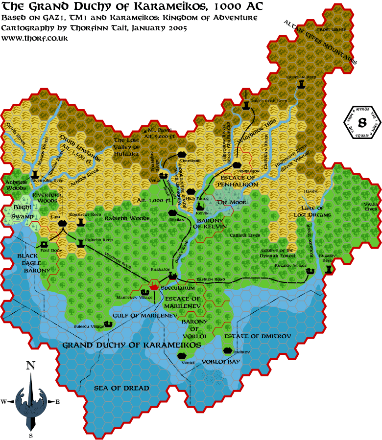
 Tuesday's Maps
I'm home for my lunch break and have a moment spare, so here is today's map.

As an added little bonus, for comparison I also have another version
without the forested hills marked on. I don't want to clog this thread
up with too many maps, but here it is.
On that subject, should I change the old maps to links as we move on?
Otherwise the thread is going to get really slow pretty quickly. Maybe
I should leave a map in the thread for a few days, then change it to a
link.
Edit: I'd like to know what you all think about the forested hexes. The
current map here includes the official take on things, as seen in
Karameikos: Kingdom of Adventure, but the text does suggest that pretty
much all the hills are forested.
Another question: do you think I should incorporate a colour gradation
for forest/heavy forest/forested hills? I often think it looks kinda
messy (cf. K: KoA, for example), but it does let you see the terrain
types better at a glance.
|
15 February 2005, 01:03 PM
|
 |
Member
|
|
Join Date: Apr 2004
Location: Denmark
|
|
Wow!!
First off: the maps are absolutely beautiful!! I love them!  
Quote:
|
Originally Posted by Thorf
Edit:
I'd like to know what you all think about the forested hexes. The
current map here includes the official take on things, as seen in
Karameikos: Kingdom of Adventure, but the text does suggest that pretty
much all the hills are forested.
|
I like the forested hills as they are in this map. I must admit it's
been so long since I read the geography bit of gaz 1 that I can't
remember how much should be forested hills instead of just hills.
Quote:
|
Another question: do you think I should incorporate a colour gradation
for forest/heavy forest/forested hills? I often think it looks kinda
messy (cf. K: KoA, for example), but it does let you see the terrain
types better at a glance. |
I prefer that the heavy forest is a darker shade of green. It "makes
sense" and provides a better glance of the terrain, I think.
Looking forward to more of these fantastic maps!
:-) Jesper
|
15 February 2005, 02:45 PM
|
 |
Member
|
|
|
|

Excellent. I'll definitely be making these available to my players.
|
15 February 2005, 05:30 PM
|
 |
|
|
Join Date: Jan 2004
Location: Italy
|
|
Awesome!
Well Thorf, keep em coming, because they're GORGEOUS!
My compliments!
Just one question: are you using Hexmapper (coz I seem to recognize
it)? If so, how long does it take to draw a map like that? I remember
that I used it to draw some pretty detailed maps of my homebrew world
and it took me hours literally, although it was too damn fun to use it
Good work !
I am particularly interested in the maps of the Isle of Dawn, Norwold
and the Arm of the Immortals, so I'm looking forward to them
|
15 February 2005, 06:03 PM
|
|
Member
|
|
Join Date: Jan 2005
Location: Akita, Japan
|
|
I'm glad you're all enjoying yourselves
I
use Adobe Illustrator 8 to make the maps. It takes a good few hours to
make each map. Depending on how much free time I have, I can manage a
map every two or three days, or faster if I haven't got a lot of work
to do. That's why I didn't start posting these things until I had quite
a bit done.
And it is a lot of fun to do, though sometimes it gets to be a bit of a
chore too. In any case the results are well worthwhile.
Quote:
|
Originally Posted by DM
Good work !
I am particularly interested in the maps of the Isle of Dawn, Norwold
and the Arm of the Immortals, so I'm looking forward to them |
Those will be coming, but don't hold your breath.
Right now I'm trying to work through the maps chronologically, to get a
feeling for how things developed and to find errors as and when they
appeared. And of course the official maps will likely come before I
start work on any conversions.
I just updated all the files because I noticed that the scale marker
hadn't rendered properly. Also, I have implemented a provisional scaled
colour scheme for forests. I deliberately made it very subtle, though
I'm not absolutely set on those shades as yet. Please check it out and
tell me what you think!
Edit: Map has been updated with what I believe to be a more aesthetic
form of shading on the forested hill hexes. Comments please!
Last edited by Thorf : 02-18-05 at 01:26 PM.
|
15 February 2005, 06:11 PM
|
|
Member
|
|
Join Date: Jan 2004
Location: Italy
|
|
Some nitpicky comments on the first KW map.
1. The World Mountain of Ethengar should be present, IMO, since it's
big enough to get its own hex in the middle of the steppes. I also
think you should show the Ethengar lakes.
2. Ierendi should sport some volcanoes, as well as Glantri.
3. X2 is marked there near the Broken Lands border but, well... it
shouldn't be there. The premise is that wherever they are the PCs are
spirited away by the mists and end up in the "prison dimension" of
Castle Amber. So you cannot really place X2 on Mystara.
4. X4 and X5 are located in the wrong position and direction. They
should point south-westwards instead of north-westwards from the Adri
Varma Plateau. Anyway I wouldn't list them at all, or if you do, You
must also add X10 (same direction) and X11 (pointing northwards from
Glantri's northern border)..
5. X7 should be placed IIRC in the waters between Thyatis and Minrothad, a bit southwards
6. X8 should be placed in one of the little isles far off the coasts of Thyatis
7. X12 should be placed in Karameikos (IIRC it's Skarda's Mirror set in... Verge?)
8. X13 should be placed in Vestland
9. CM8 should be placed in Glantri
10. CM9 should be placed in Darokin, very close to the southern Alfheim border
That's all for now
|
15 February 2005, 06:24 PM
|
|
Member
|
|
Join Date: Jan 2005
Location: Akita, Japan
|
|
Thanks for the corrections, it'll be useful for my proceeding updates to the map. 
But I think you kinda missed the point of this map in the first place -
it's supposed to have all the errors, because it's Mystara as we saw it
for the very first time way back in 1983.
As I work through the maps in roughly the order they were made, I will
update this map, until eventually it becomes the Mystara we know today.
I probably should have explained better, but the reason for doing it
this way is that it's worth having the original maps to refer back to
when the newer ones (Wrath of the Immortals, for example) screw
something up. 
I can see how it might be confusing, since the next one I released was an entirely up-to-date map of Karameikos...
You've actually given me a good excuse to post another map, that should help you understand what I'm doing here. 
It's an exact replica of the original Expert Set map, using my hexes.
Add X1's map and the tiny map in X3, and you have my current Known
World and Sea of Dread map, the first one in this thread.
Confused yet? 
|
15 February 2005, 08:48 PM
|
 |
Member
|
|
Join Date: Apr 2004
Location: Andover, United Kingdom
|
|
Beautiful work and I can't wait to see more.
However, I can't find your Karameikos map with forested hills - at the
time of posting both versions on your Mystara page are identical...
__________________
"If it looks like a duck and quacks like a duck it might just be a crow."
|
15 February 2005, 09:54 PM
|
 |
Member
|
|
Join Date: Mar 2004
Location: Norway, Europe
|
|
I love these maps Thorf!
It is interesting that you are planning to present many different alternative versions of the maps, based on various originals.
If you are interested, I have some ideas for incorporating non-canon
elements in some of them in the future aswell, though I understand that
you will probably want to go through the canon versions first.
Another thing Id like to see is maps using a different focus. For
instance a map showing the Known World and Sindh, The Known World +
Wendar/Heldann/Denagoth or The Known World + The Isle of Dawn. I have
been working on such maps myself and I find that if I move away from
the traditional perspective, I find very interesting results.
As The Known World developed, it makes more sense if there is just as
much interraction between mainland Thyatis and the Isle of Dawn as
there is between Thyatis and the rest of the Known World for instance.
Håvard
|
15 February 2005, 09:56 PM
|
|
|
Its
slightly diffrent, the forested hills are there. They have a small tree
in the uper left corner with a small hill in the botem right
corner...also the heavey forested areas are a darker shade of green on
the second map...hehe...
|
15 February 2005, 10:19 PM
|
|
Member
|
|
Join Date: Jan 2005
Location: Akita, Japan
|
|
Yes, I agree
The
world shouldn't just be limited to the small part of southeastern Brun
that we all know so well. This is one of the great benefits of computer
mapping - once you have the maps in the computer, it's a simple matter
of cutting and pasting the bits you want. And of course eventually you
want to be able to easily assemble maps of wherever you want, in any of
the three major scales.
I do indeed plan on dipping into non-canon stuff, but you are correct
that I am planning on going through the official maps first. It seemed
appropriate to start at the beginning, especially after realising that
starting at the end brings up lots more inconsistencies. But that
discussion is for the other thread...
Anyway, rest assured that all those areas are on my list, and I will
get to them before too long, I hope. And doubtless discover new fun
along the way.
On another note, I have decided to revise the forest hex shading once
again. This time I'm going to shade both heavy forests and forested
hills the same, ever so slightly darker colour. I just couldn't find a
suitable colour for the forested hex tile, and this solution seems to
work. Once again, if there are any more suggestions or comments on
this, I'd love to hear them.
The image in this thread should be updated shortly...
|
16 February 2005, 12:26 AM
|
|
Member
|
|
Join Date: Jan 2005
Location: Akita, Japan
|
|
 That's all for today
I just updated the second Karameikos map in this thread with the latest forest hex shadings, please tell me what you think.
Today I got some interesting offers for help from a number of people. I
hadn't really considered that people would want to help, but now I'm
considering putting together a team to work on my project. If anyone's
interested, please e-mail me. I do realise that no one actually knows
exactly what the project is yet, other than mapping. 
I've managed to resist posting another map tonight, so the next map
should be posted tomorrow at lunchtime, about twelve hours from now.
See you then! 
|
16 February 2005, 12:34 AM
|
 |
Member
|
|
Join Date: Feb 2005
Location: Montreal
|
|
Great
maps! I think the forest shadings are reversed, though - heavy forest
should be the darkest green, and forested hills in the middle.
Somebody mentioned Hexmapper - I tried it, but I couldn't do much with
it - it seemed like it had a fixed-size hex grid that I couldn't
expand, and I couldn't see any way to draw coastlines or rivers. Did I
miss something?
Instead, I just started writing my own. What I want is a mapping
program that I can use to scroll and zoom maps, so that I can start
with a 72-scale map of most of known Mystara, click on the Known World
to zoom into it, and then click on a country to zoom in to that. I'm
also thinking of writing a scanner to look at picture files and build
maps for my tool out of them. (Hexagons can't be too hard to recognize,
can they?) But I just started thinking about this last week (before I
discovered this board) and I'm notorious for getting excited about a
project and dropping it a few weeks later, so no promises.
|
16 February 2005, 02:20 AM
|
 |
Member
|
|
Join Date: Mar 2004
Location: Stockholm, Sweden. For a while.
|
|
Simply lovely.
|
16 February 2005, 02:25 AM
|
 |
Member
|
|
Join Date: Jun 2003
Location: Christiansburg, VA. North of Specularum.
|
|
Making coastlines on HexMapper maps.
|
16 February 2005, 01:35 PM
|
|
Member
|
|
Join Date: Jan 2005
Location: Akita, Japan
|
|
 Lots to talk about today
First, here's today's map.

I already spotted the missing battlefield symbol in the bottom left,
and it will be fixed next time I upload files, probably tomorrow.
Otherwise, this should be a completely up to date map of Ylaruam for AC
1000.
It seems likely that I'm going to continue in Gazetteer order, more or
less. But I might pull a few surprises later on, so don't count on it.
|
16 February 2005, 02:33 PM
|
|
Member
|
|
Join Date: Mar 2004
Location: Ontario, Canada
|
|
Alright!
The PCs IMC are heading to Ylaruam this Saturday from Vestland; perfect
timing. I'm actually pretty excited because I've never had characters
go there before!
Quote:
|
Originally Posted by Thorf
First, here's today's map.
|
Today's map!!!! It's late, I'm going to bed! What do you live on the other side of the world or something!
|
16 February 2005, 03:01 PM
|
|
Member
|
|
Join Date: Jan 2005
Location: Akita, Japan
|
|
Cool
Quote:
|
Originally Posted by Hugin
Alright!
The PCs IMC are heading to Ylaruam this Saturday from Vestland; perfect
timing. I'm actually pretty excited because I've never had characters
go there before!
|
I'm glad I could be of service. Hope you have a fun game.
Quote:
|
Today's map!!!! It's late, I'm going to bed! What do you live on the other side of the world or something!
|
Hehe, nah just the opposite side of the hemisphere really. I did consider when I started this thread that my days probably won't correspond with those of anyone else reading this. 
On a totally unrelated note, I got sidetracked in my posting here just
now, because I suddenly decided to revise all my hexes. After noticing
that the Broken Lands tiles on the Ylaruam map weren't up to date with
my most recent version, instead of simply updating them I decided it
was finally time to redo the tile. That prompted me to revise a whole
set of tiles to make them look slightly finer, and I ended up totally
redrawing my volcano too, which I had been putting off for ages.
So, soon I will be uploading the corrected Ylaruam file as well as
updating the Legend file at the top of the page in this thread! Keep
your eyes peeled (those of you who aren't asleep, that is ).
|
16 February 2005, 03:21 PM
|
|
Member
|
|
Join Date: Jan 2005
Location: Akita, Japan
|
|
Forest shades, Hexmapper and mapping programs
Quote:
|
Originally Posted by Joe Mason
Great
maps! I think the forest shadings are reversed, though - heavy forest
should be the darkest green, and forested hills in the middle.
|
Interesting. I did notice that they were like that in Karameikos:
Kingdom of Adventure, but I've never liked that map, to be honest. I
think the shading differences there are too stark, and end up making
the map look kinda ugly.
But anyway, for now I have gone with a single very subtle shade which I
have given to both heavy forests and forested hills. It seems to work
okay so far. I've also considered changing the colour of the forested
hills tree to match the hills, though I would like to keep it
"tree-coloured" and reserve the darker shade for Alfheim's Great Home
Trees.
Quote:
|
Somebody mentioned Hexmapper - I tried it, but I couldn't do much with
it - it seemed like it had a fixed-size hex grid that I couldn't
expand, and I couldn't see any way to draw coastlines or rivers. Did I
miss something? |
I can't really remember which program I tried, but in any case I think
in the end Illustrator is the most powerful tool. That doesn't
necessarily make it the best, though, because more specialised programs
can provide a certain amount of automation for mapping - if they're
done right.
Quote:
|
Instead, I just started writing my own. What I want is a mapping
program that I can use to scroll and zoom maps, so that I can start
with a 72-scale map of most of known Mystara, click on the Known World
to zoom into it, and then click on a country to zoom in to that. I'm
also thinking of writing a scanner to look at picture files and build
maps for my tool out of them. (Hexagons can't be too hard to recognize,
can they?) But I just started thinking about this last week (before I
discovered this board) and I'm notorious for getting excited about a
project and dropping it a few weeks later, so no promises. |
That sounds great! My project encompasses maps for all those areas, in
all three scales, although it's still in the early stages. If you can
use the Illustrator files for my maps to power your program, that would
end up being a very nice program, I think.
The other mapping tools you mention also sound very interesting. Please
keep us informed on your progress! And if I can be of any assistance, I
will be happy to help in any way I can.
|
16 February 2005, 03:23 PM
|
|
Member
|
|
Join Date: Jan 2005
Location: Akita, Japan
|
|
Quote:
|
Originally Posted by maddog
|
Very nice maps, Ray! Did you do the hex art yourself? They look
extremely similar to the official hexes. It's great to see such high
quality maps.
|
16 February 2005, 06:41 PM
|
|
Member
|
|
Join Date: Jan 2005
Location: Akita, Japan
|
|
Forested Hills and Karameikos
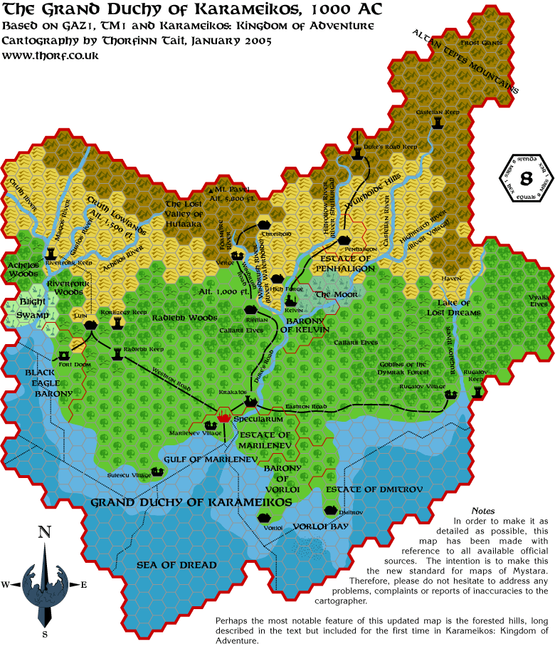
I've been researching this issue, and here's what I came up with.
Quote:
|
Originally Posted by GAZ1 p.35, "Land Patterns"
These mountains tend to be thickly covered with forest vegetation,
gradually thinning to bare rock toward the peaks. The average height of
mountains in this range is about 4,000 feet, though many are much
larger.
South of this mountain range, you have miles and miles of mountain foothills - also thickly covered with forest.
|
...and...
Quote:
|
Originally Posted by GAZ1 p.35, "Terrain"
Karameikos is one of the most thickly-wooded nations of the world. In the northern parts of the Grand Duchy, pine forests cover the mountain slopes and the hillsides.
The further south you get, the more hardwoods - oak especially - you
see; in the southernmost parts of the Dymrak Forest of eastern
Karameikos, all you see are ancient oaks towering into the sky.
[It continues, describing the "three great tracts of forest" in
Karameikos. The description of the forests doesn't mention anything
about hills, but doesn't rule out forested hills as parts of those
forests either.]
|
...and...
Quote:
|
Originally Posted by GAZ1 p.6, "The Map"
Callarii Lands
The Callarii elves live in the central forests east and west of Kelvin and in the forested foothills south of the gnomish community [Highforge].
|
It seems, then, that the situation is a lot more complex than we first
thought. According to this, there should be evergreen forested hill
hexes at the foot of the mountains, changing into deciduous forested
hexes as the altitude drops. And almost all the hills in Karameikos are
apparently forested.
An interesting side-point from p.35 is that apparently the Achelos
Woods and the Riverfork Woods are one and the same - Achelos is
presumably the traditional Traladaran name, Riverfork the Thyatian
name. It says, "Farthest west, near the border, is a thick forest area
variously called the Riverfork Woods and the Achelos Woods."
Karameikos: Kingdom of Adventure confirms this, and the map in that
book also agrees.
Talking of which, an examination of Karameikos: Kingdom of Adventure
proves that it states all the things I listed above, and in almost
exactly the same words.
So to get back on topic. here's my current conclusion:
- The first hex or two next to the mountains should be evergreen forested hills.
- All other hexes except a token few should be deciduous forested hills.
Is anyone interested in seeing a map made up to illustrate the point?
|
16 February 2005, 07:17 PM
|
|
Member
|
|
Join Date: Jun 2003
Location: Liverpool, England
|
|
Quote:
|
Originally Posted by Thorf
Is anyone interested in seeing a map made up to illustrate the point?
|
Yes please 
|
16 February 2005, 10:55 PM
|
|
Member
|
|
Join Date: Apr 2004
Location: Denmark
|
|
forested hills
Quote:
|
Originally Posted by Thorf
Is anyone interested in seeing a map made up to illustrate the point?
|
Oh yeah!
:-) Jesper
|
16 February 2005, 11:53 PM
|
|
Member
|
|
Join Date: Mar 2004
Location: Norway, Europe
|
|
Keep it up Thorf! New maps like this all the time is very inspiring!
I like the map of Ylaruam alot! Perhaps at a later time, you could name
a similar one of Ancient Nithia, by just replacing the hexes and adding
the river Nithia? James Mishler did a map of Nithia already that you
could use as a basis. I guess this would be another thing for later,
eh?
Håvard |
17 February 2005, 12:46 AM
|
|
Member
|
|
Join Date: Jan 2005
Location: Akita, Japan
|
|
Here's a quick and dirty Karameikos...
...with forested hills throughout!
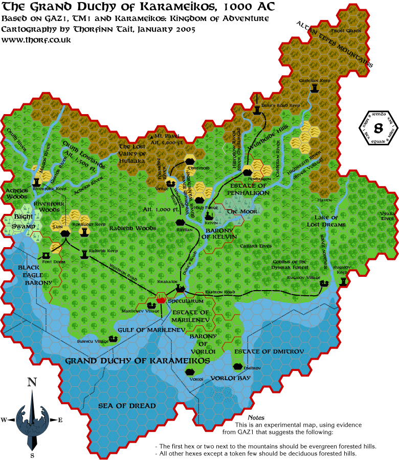
To be honest, faithful as this is to the Gazetteer's text, I think it's going a bit too far.
As for Nithia... While I was doing the Rockhome map a few weeks ago, I
came across the source for the River Nithia again, and I added old
Nithia to my "wish list" for maps to make.
It would be a fun one to do... I'd probably use the Hollow World
Nithian Empire as a major source/inspiration. It would be fun putting
pyramids all over Ylaruam!
But as you say, it'll be a while before I get to it.
Well, that's all for me from today. Seemed like a long day. See you again tomorrow for another map.
PS - I'm starting to think that forested hexes would look better with
just the normal "plains" colour for their background. Do you think it's
enough to just have the heavy forests shaded? I'm still open to
opinions and suggestions. |
|
|
 Jan 2006
 Feb 2006
 Apr 2006
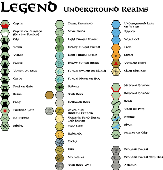 Apr 2013
 Jun 2005
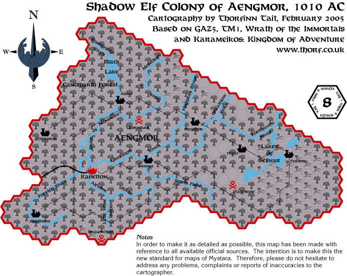 Feb 2005
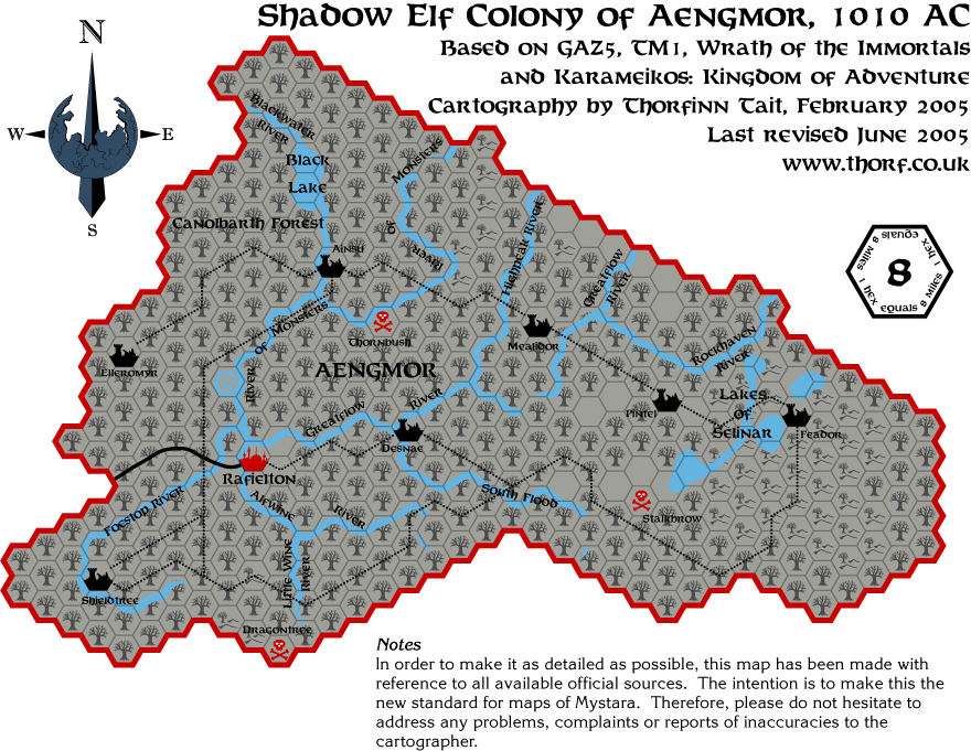 Jun 2005
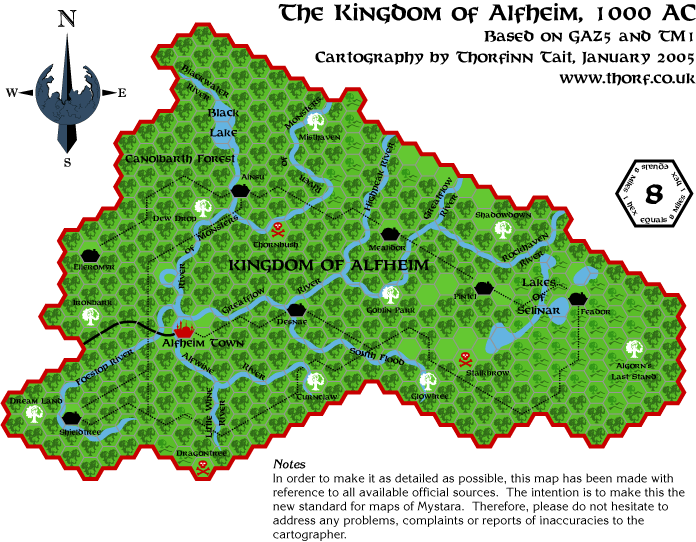 Feb 2005
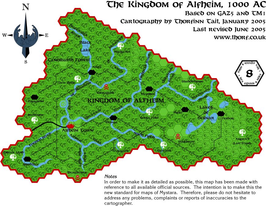 Jun 2005
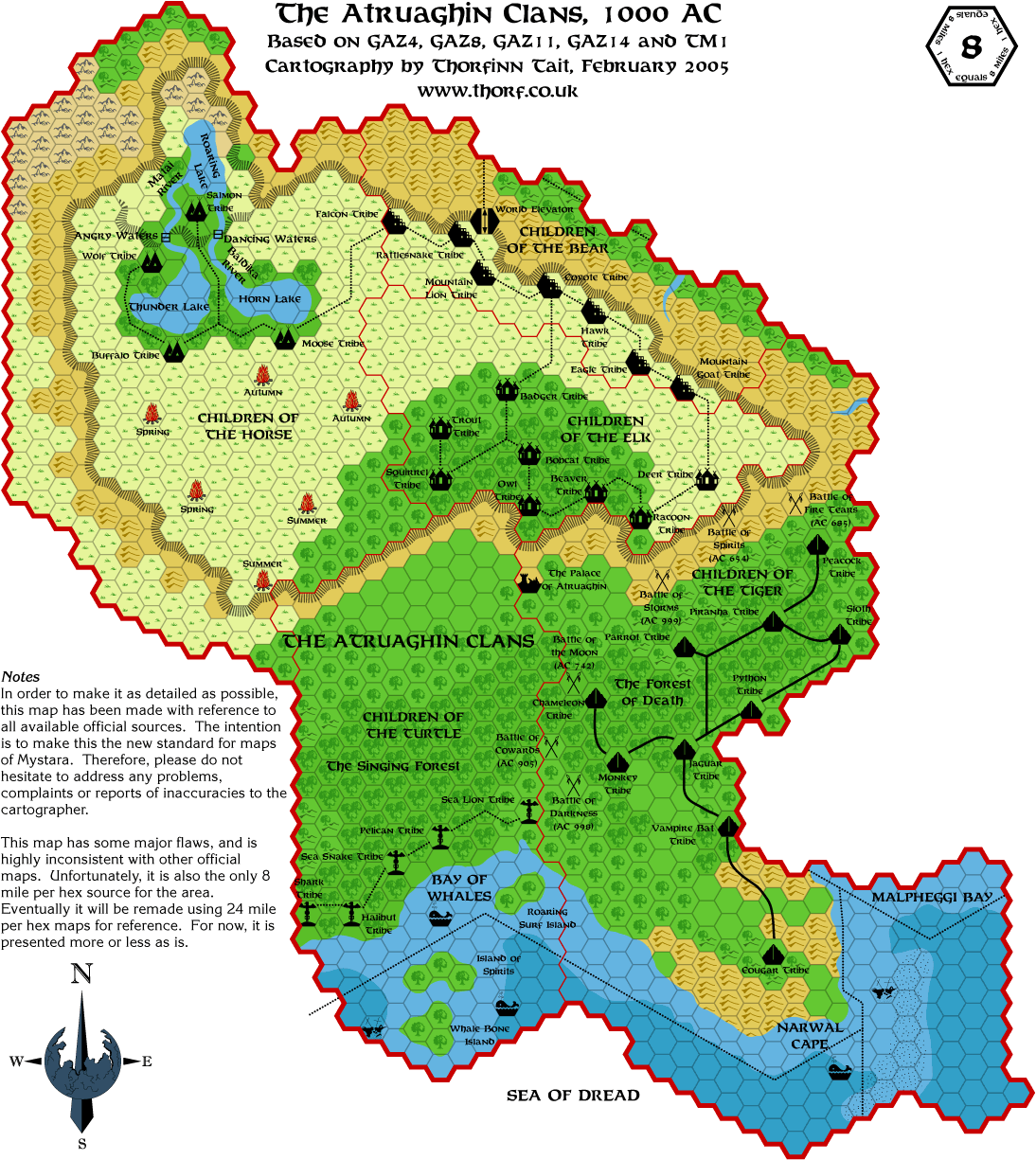 Mar 2005
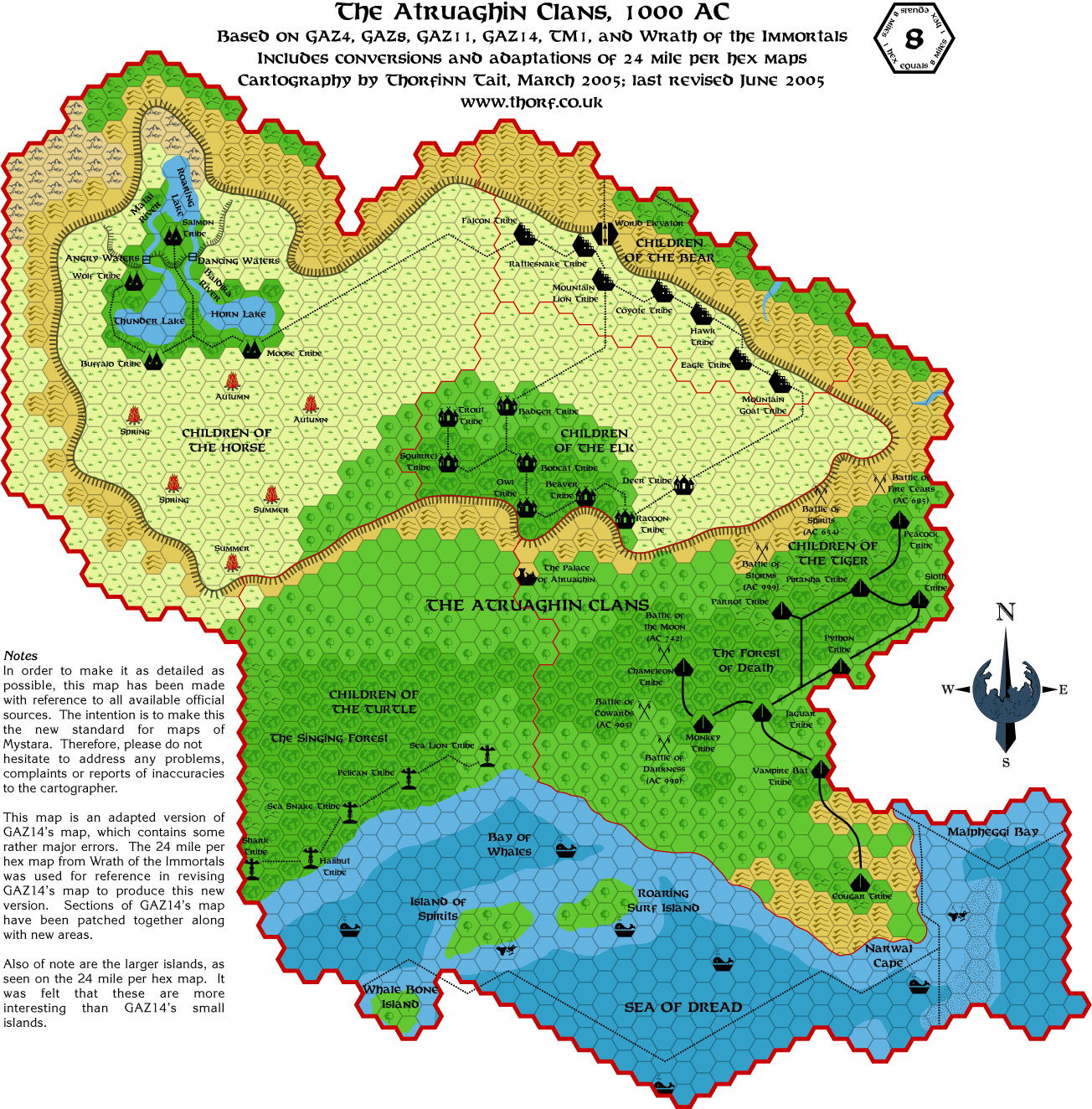 Jun 2005
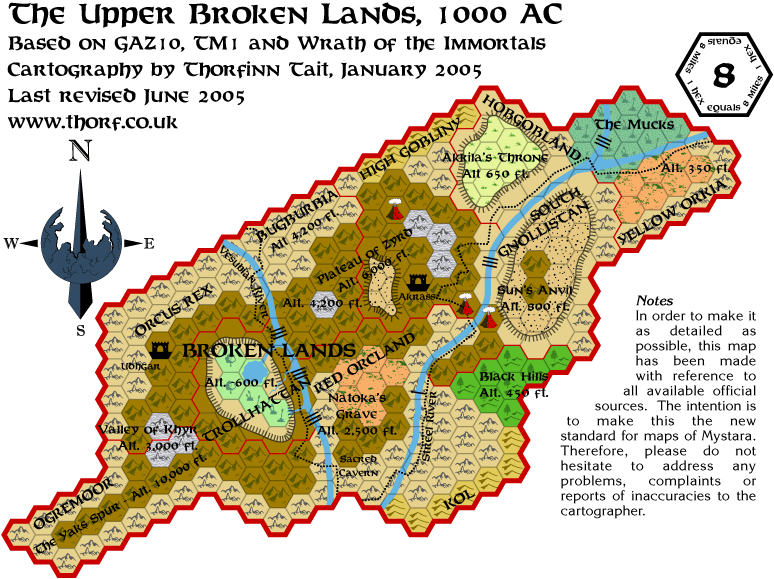 Jun 2005
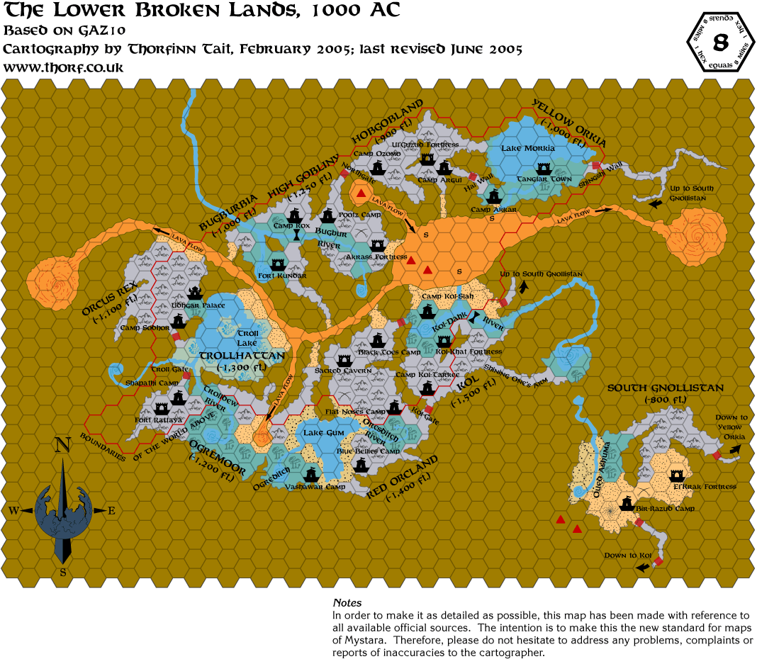 Jun 2005
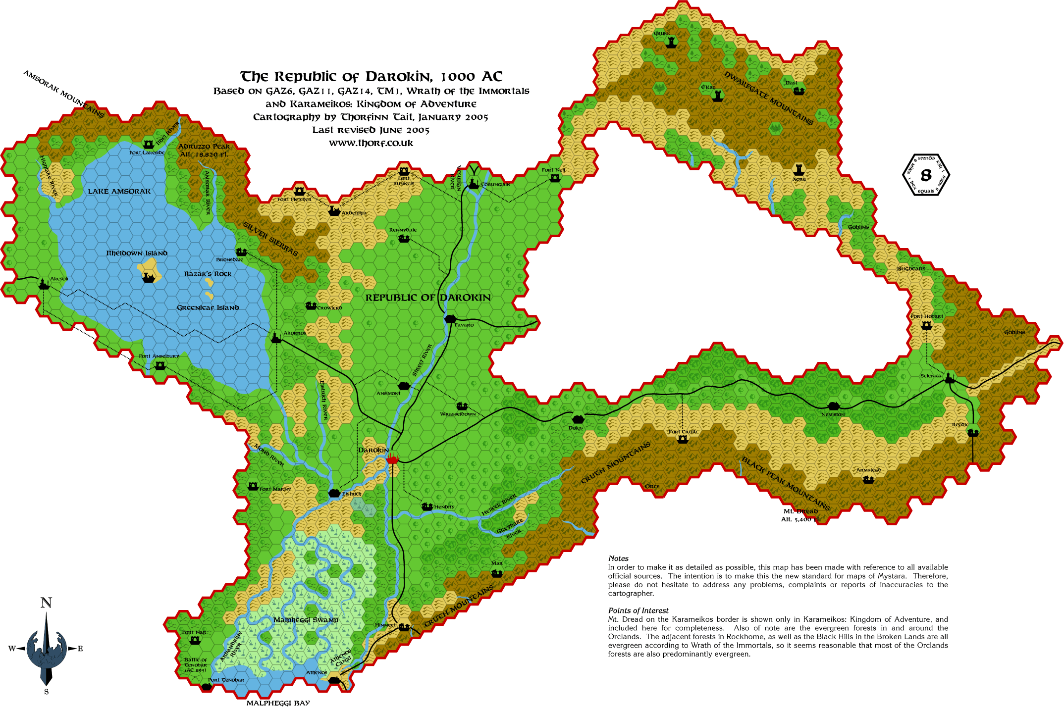 Jun 2005
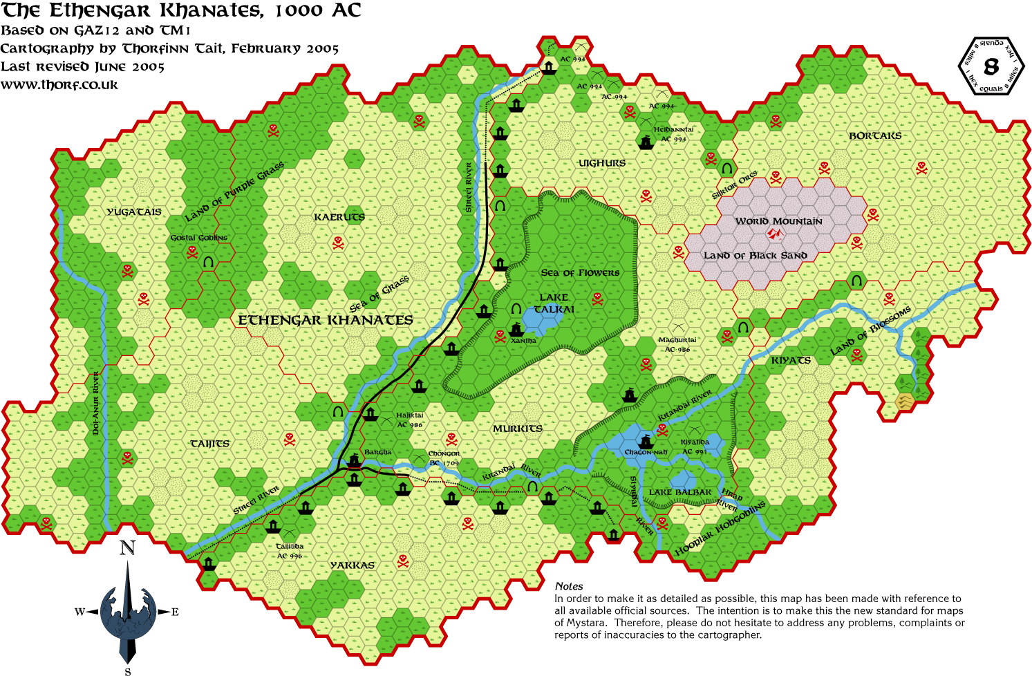 Jun 2005
 Jun 2005
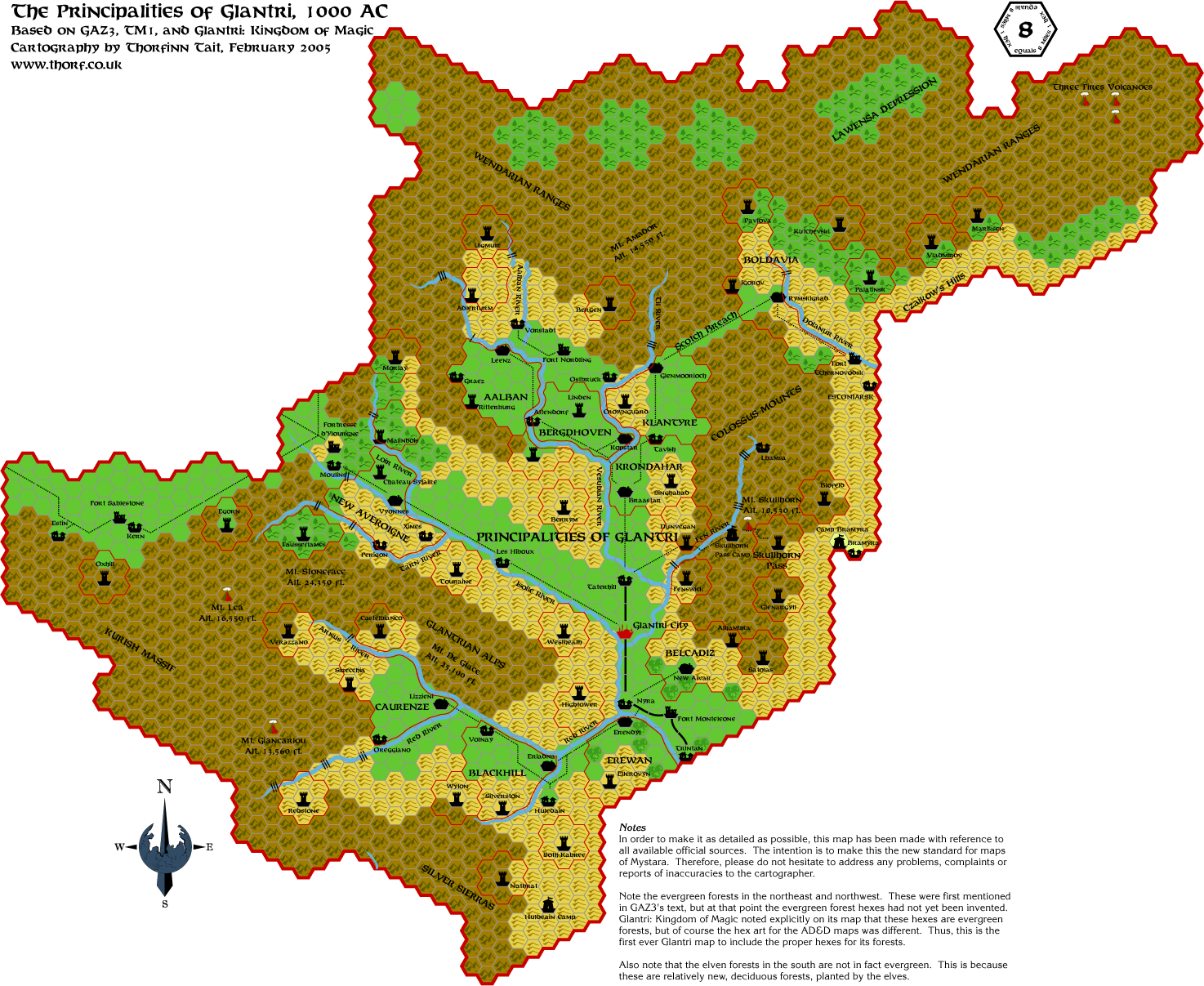 Feb 2005
 Jun 2005
 17 Feb 2005
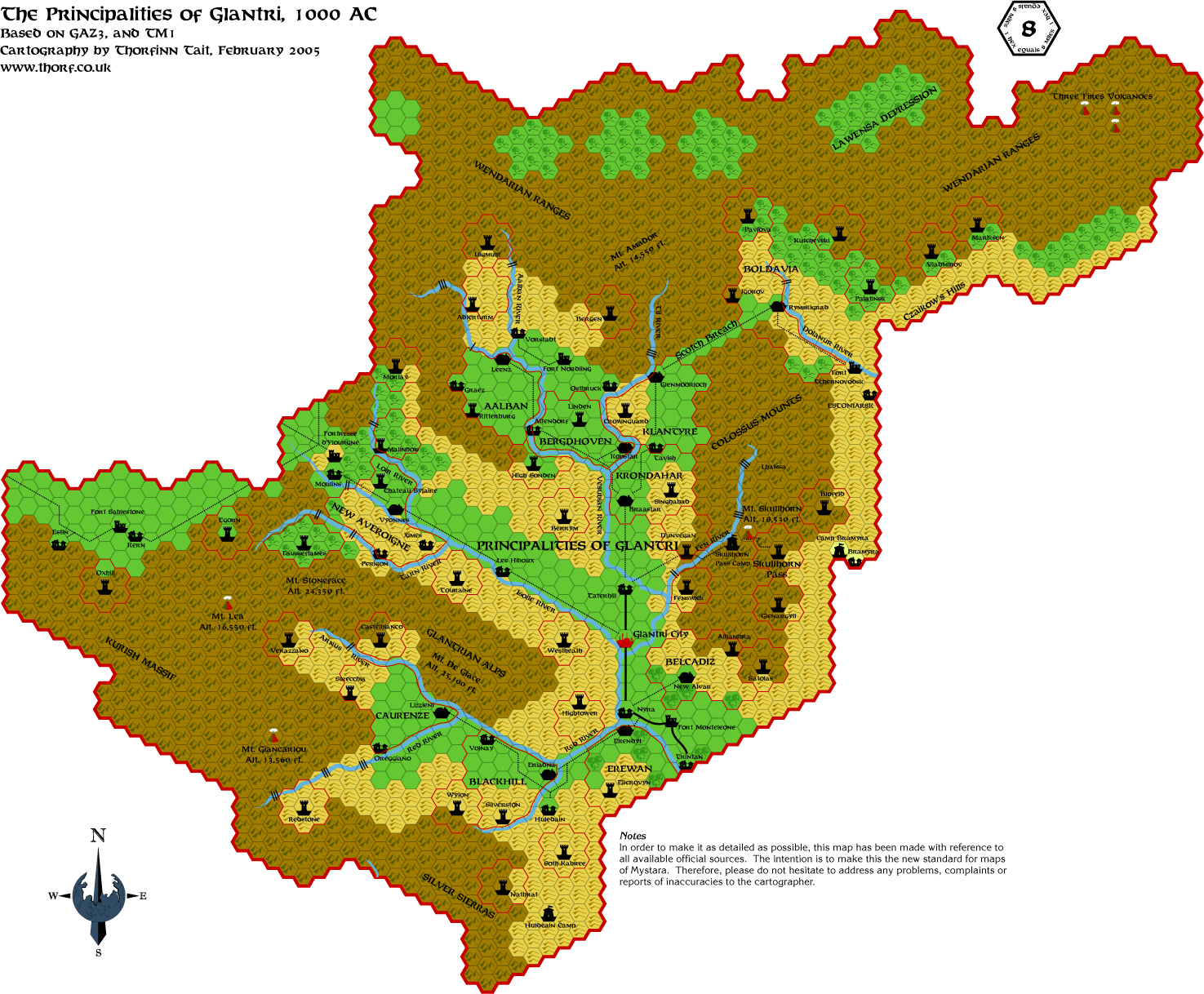 22 Feb 2005
 Jun 2005
 Feb 2006
 Apr 2006
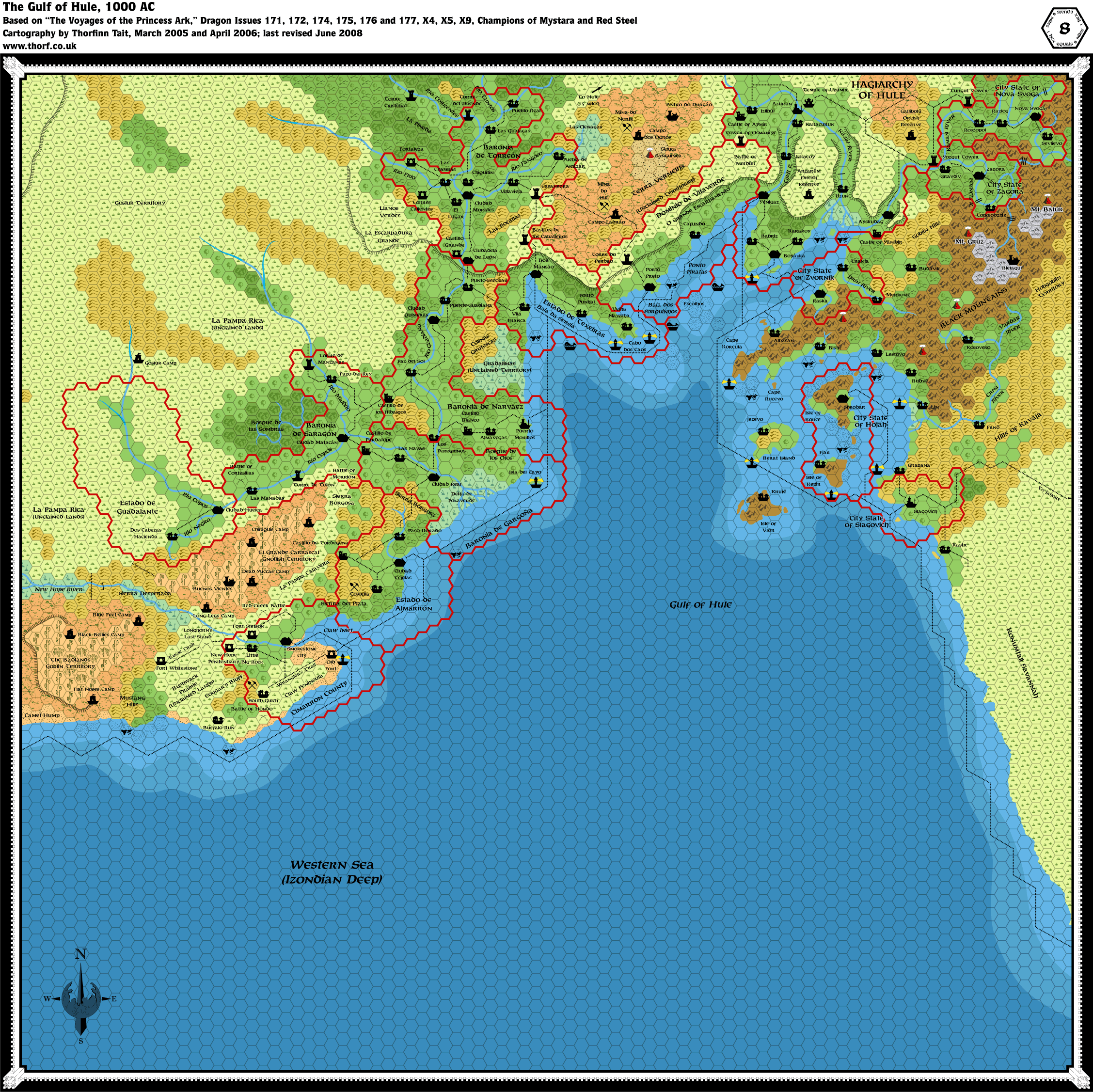 Jun 2008
 Aug 2008
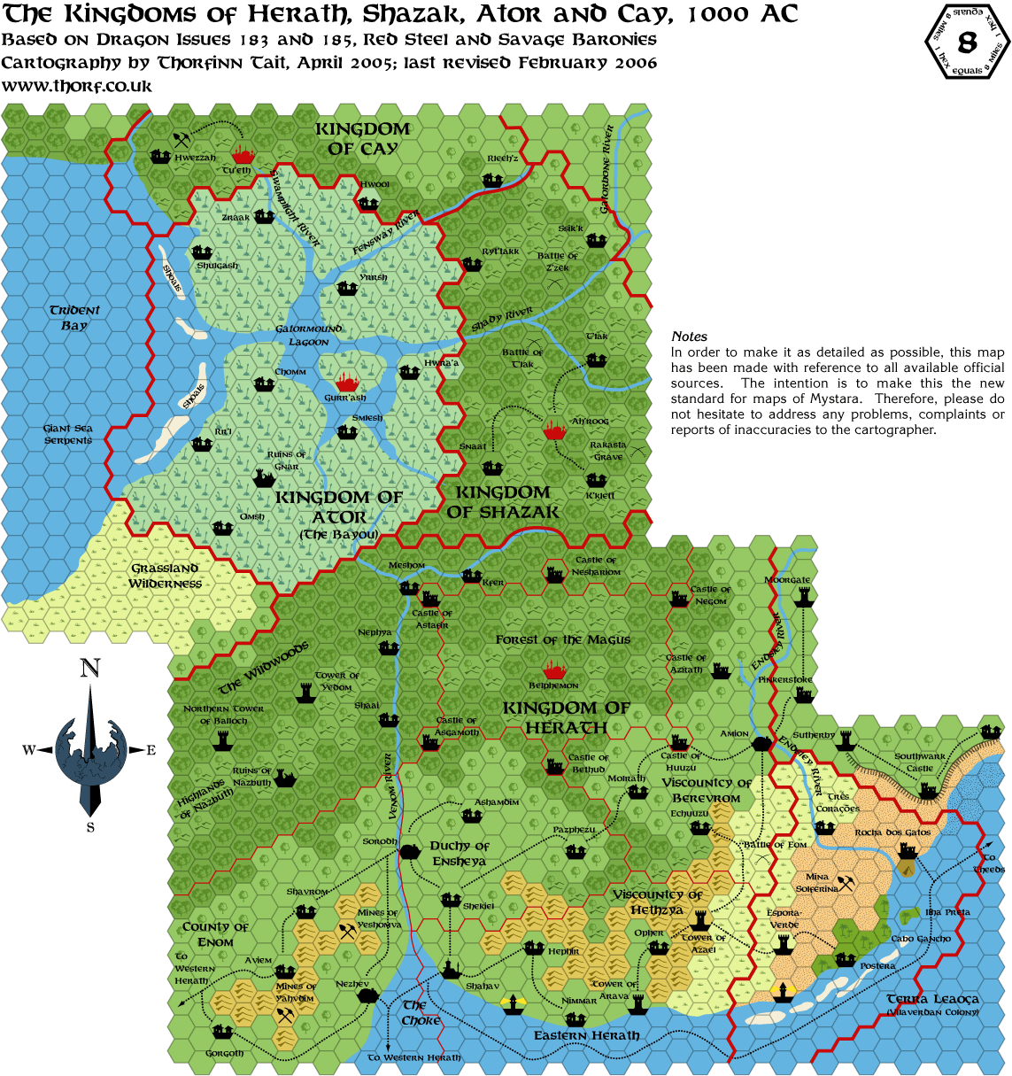 Feb 2006
 Aug 2008
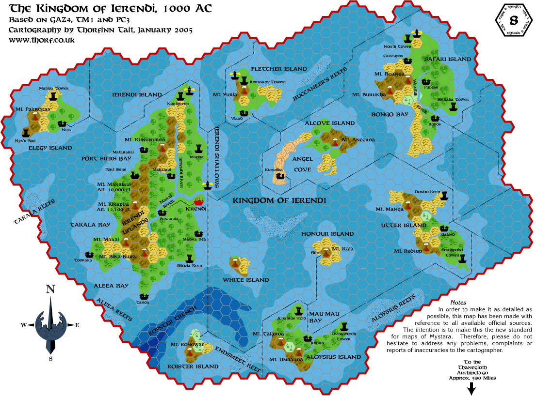 Feb 2005
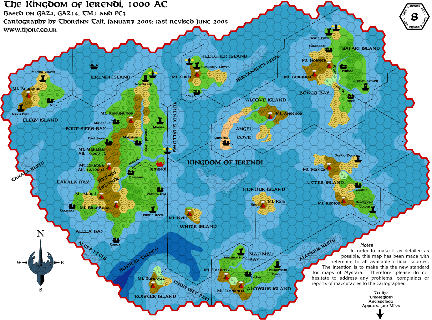 Jun 2005
 Jun 2005
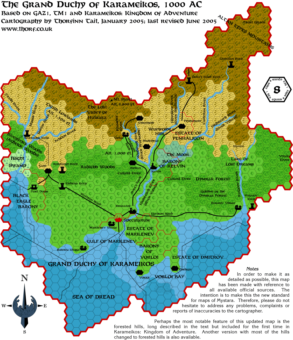 Jun 2005
 Aug 2008
 Jun 2005
 Feb 2005
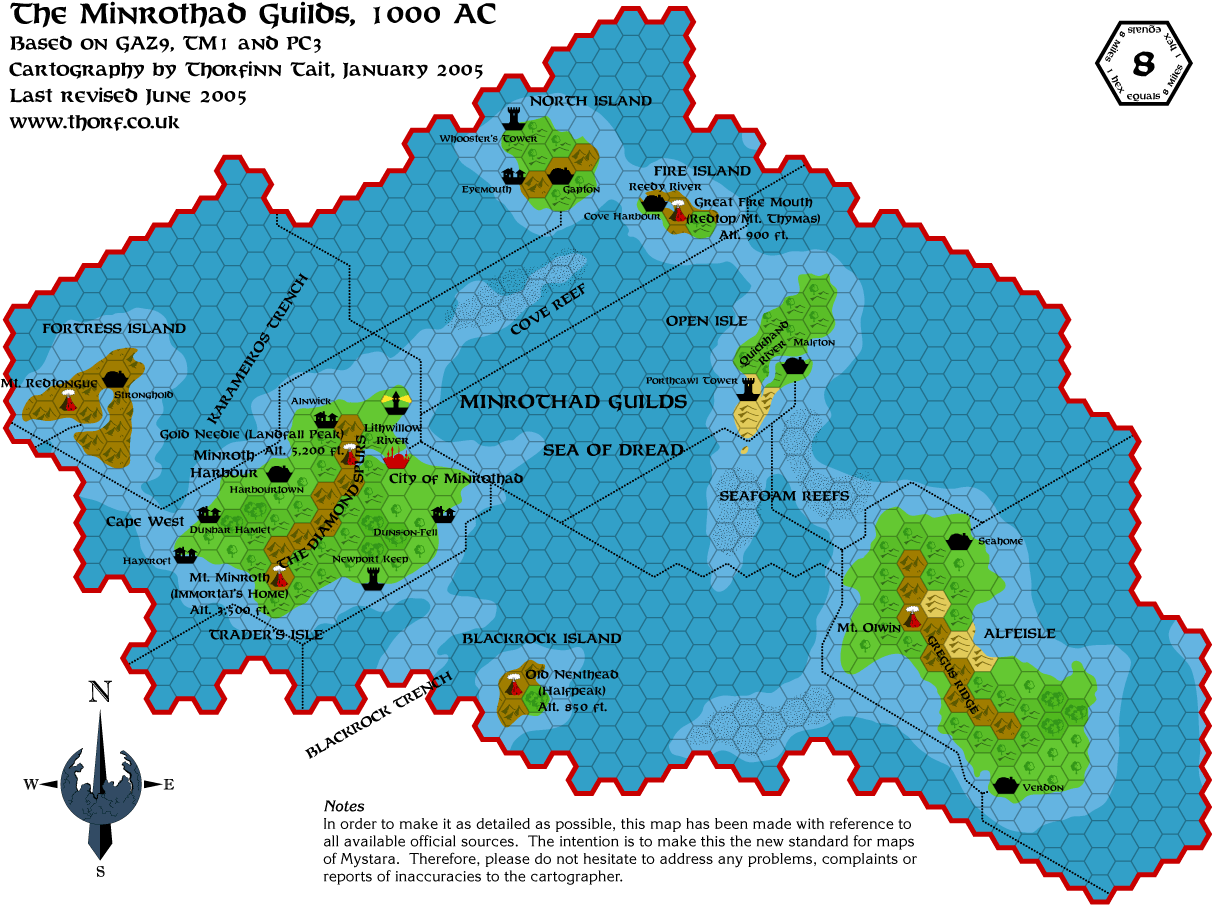 Jun 2005
 Jan 2016
 Jun 2005
 Jun 2005
 Jun 2008
 Nov 2015
 Feb 2018
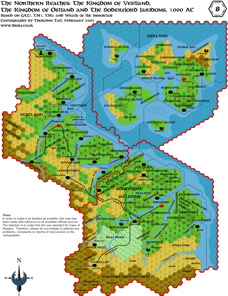 21 Feb 2005
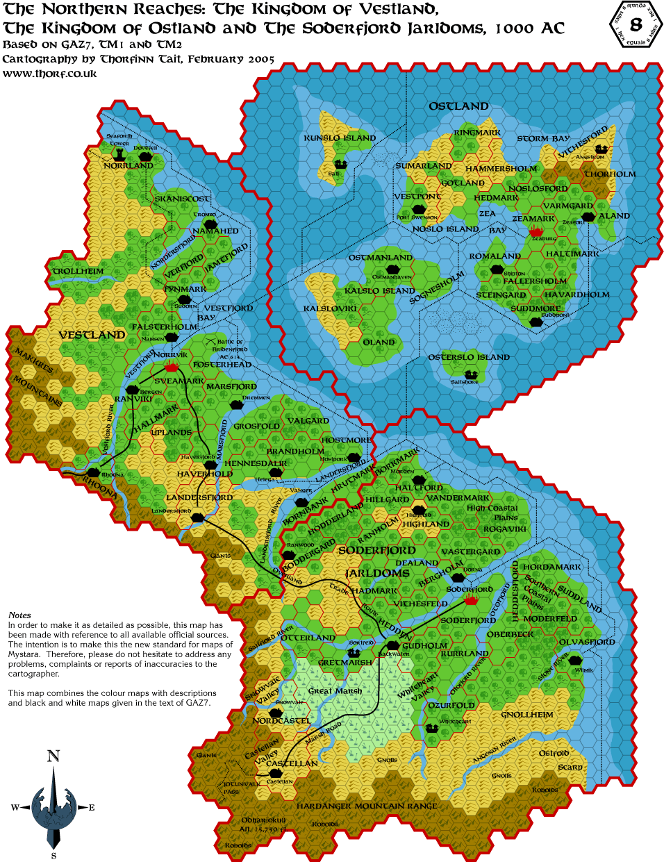 26 Feb 2005
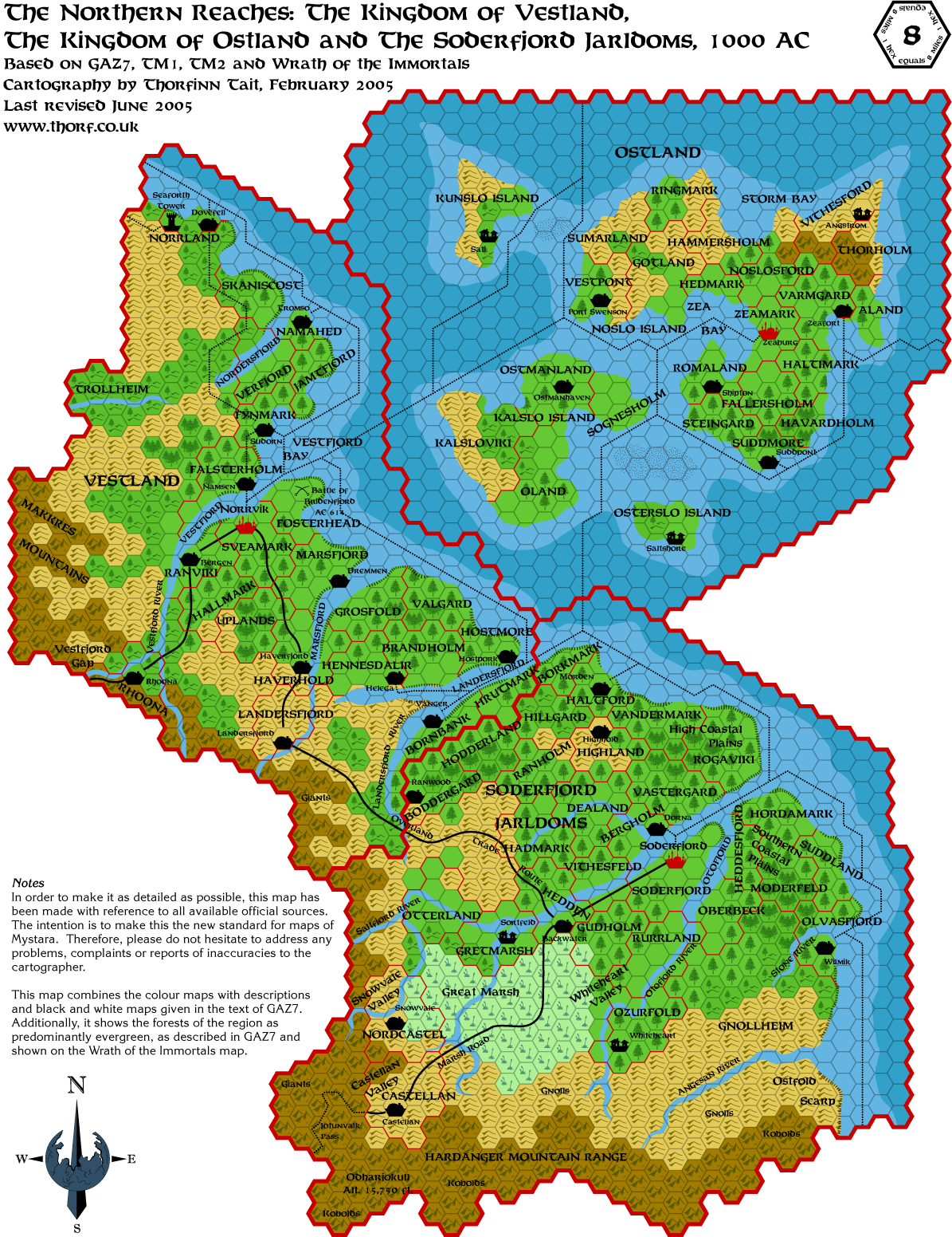 Jan 2006
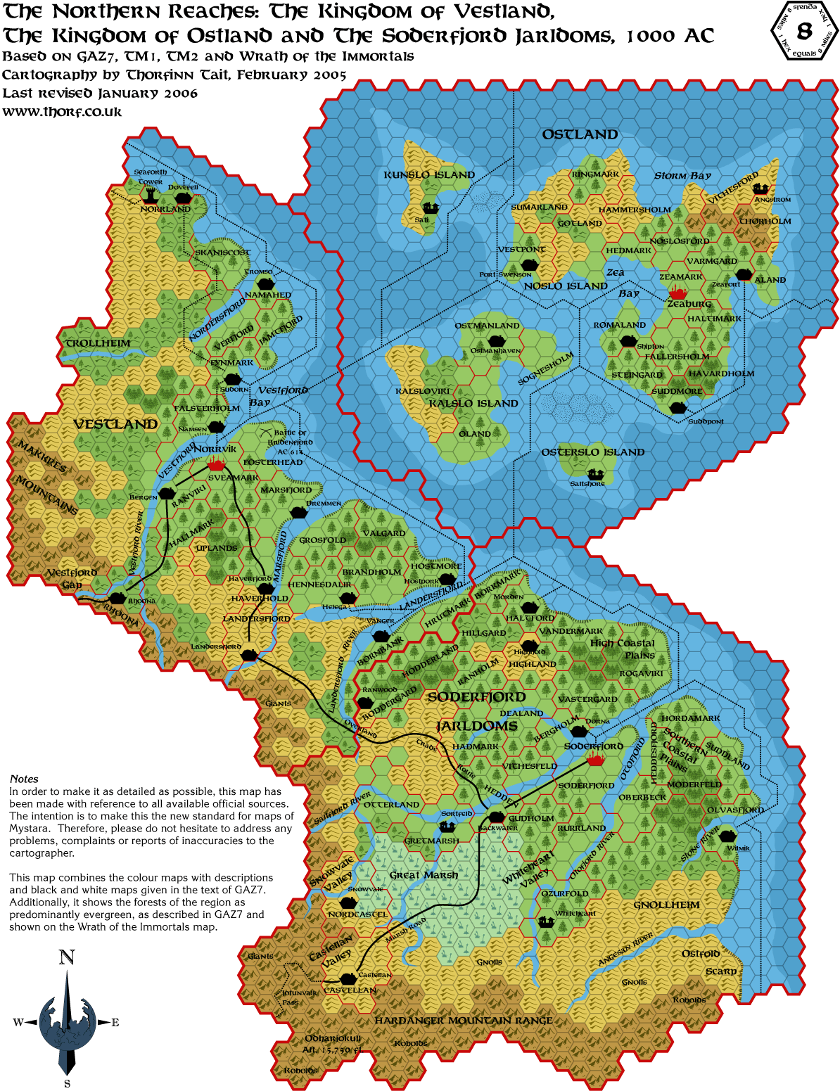 Feb 2006
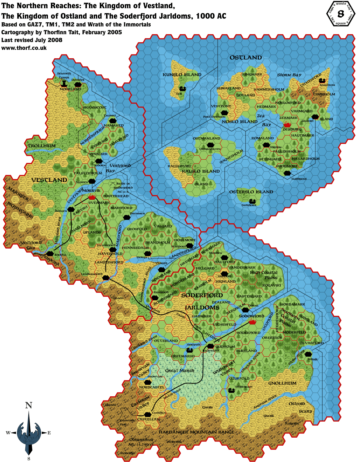 Jul 2008
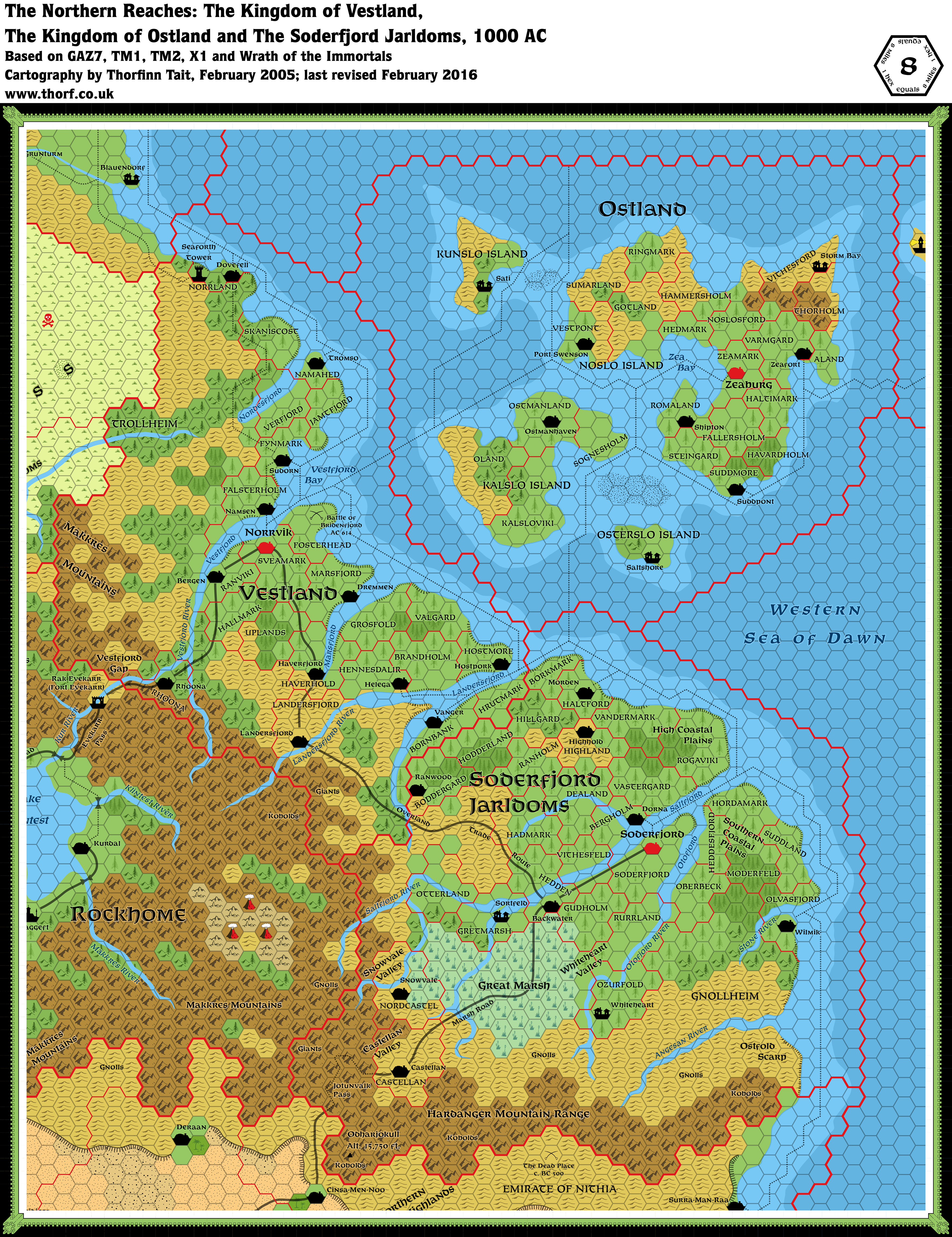 Mar 2016
 Feb 2007
 Feb 2005
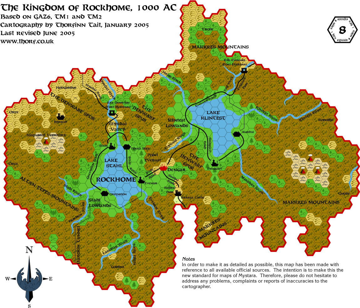 Jun 2005
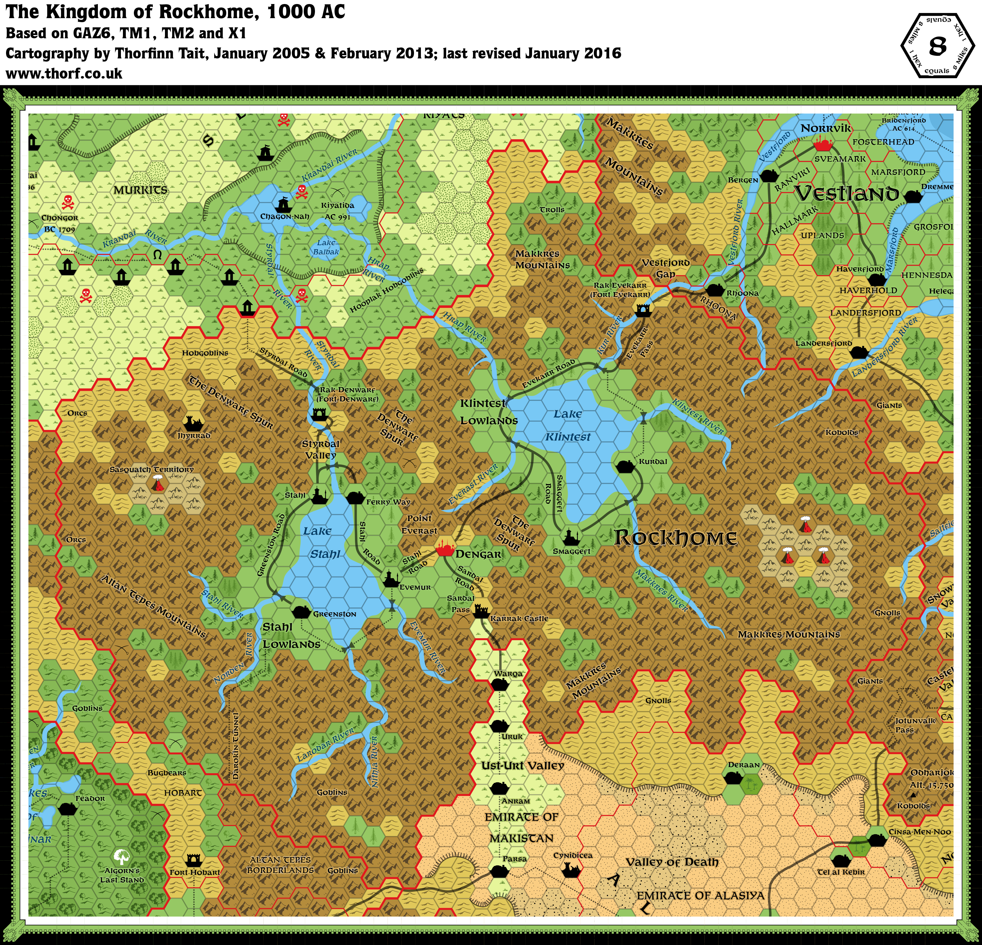 Jan 2016
 Feb 2006
 Apr 2006
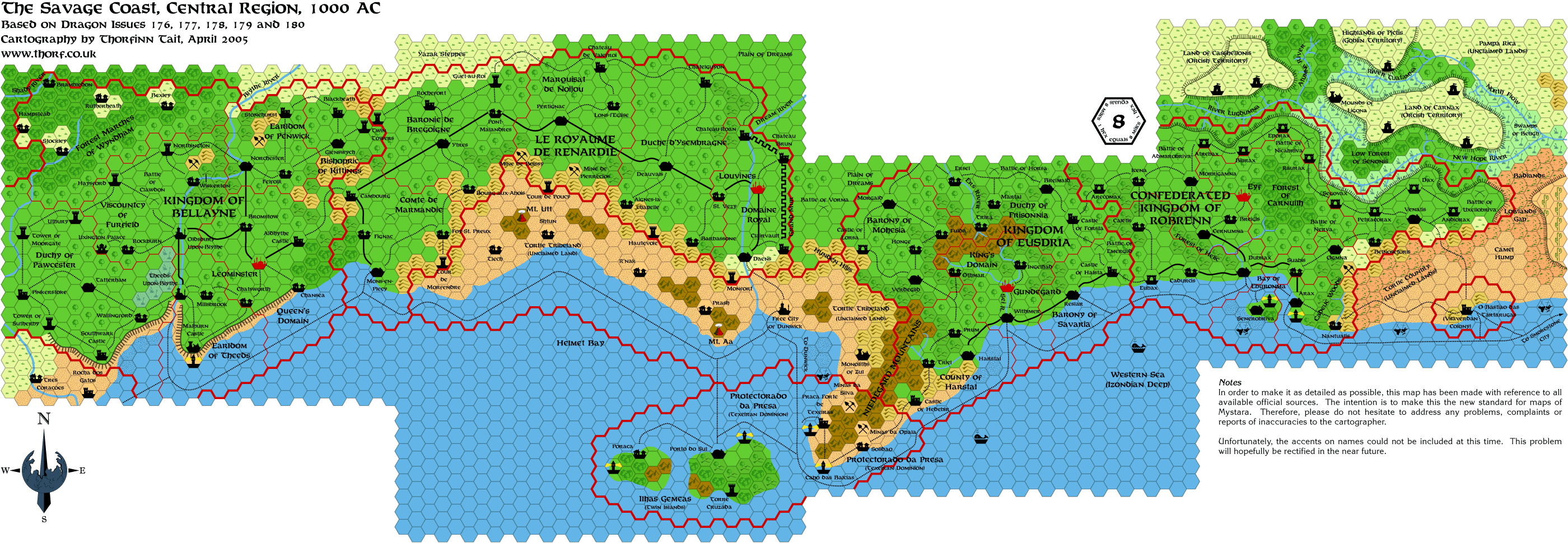 Jun 2005
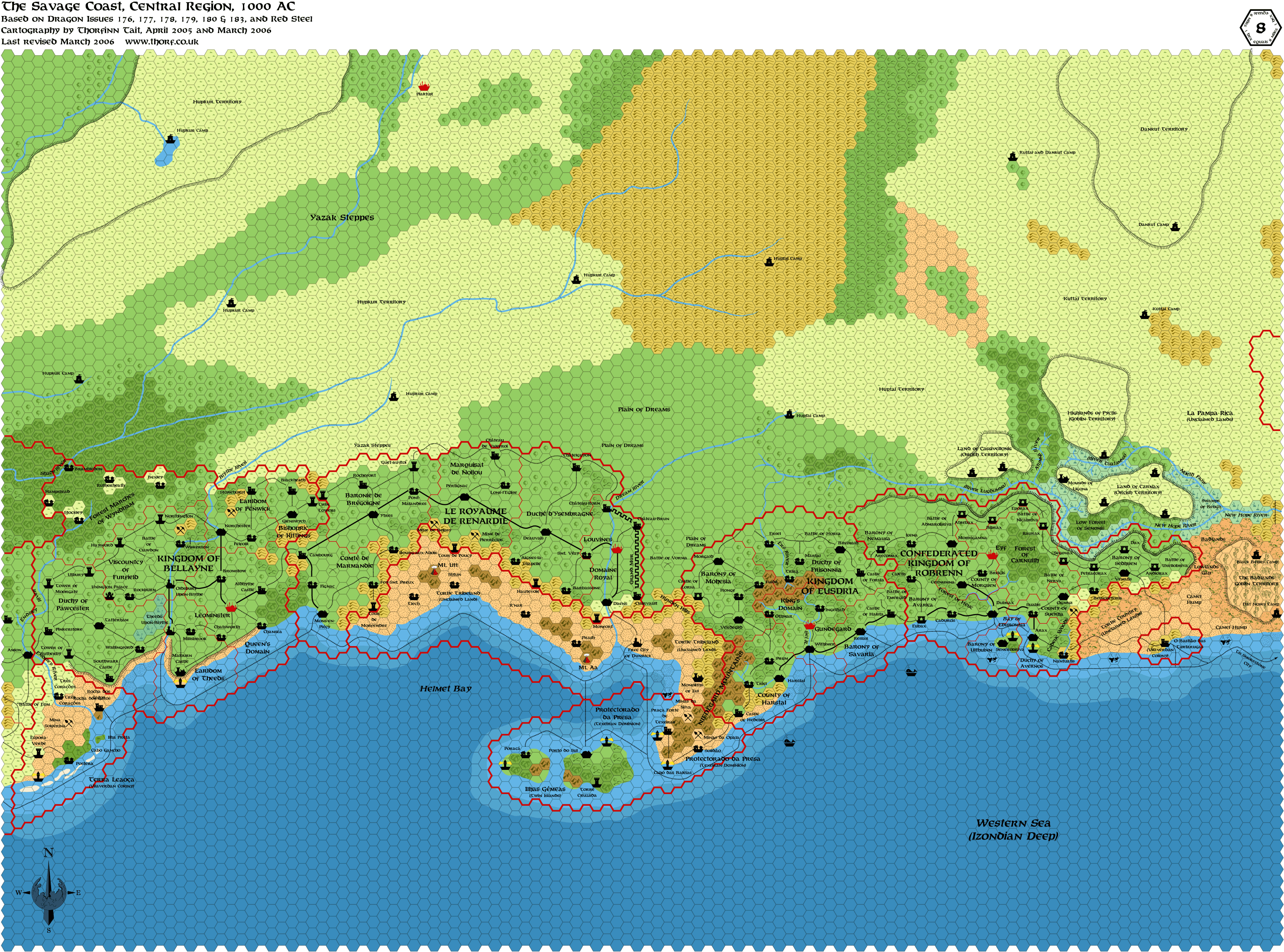 Mar 2006
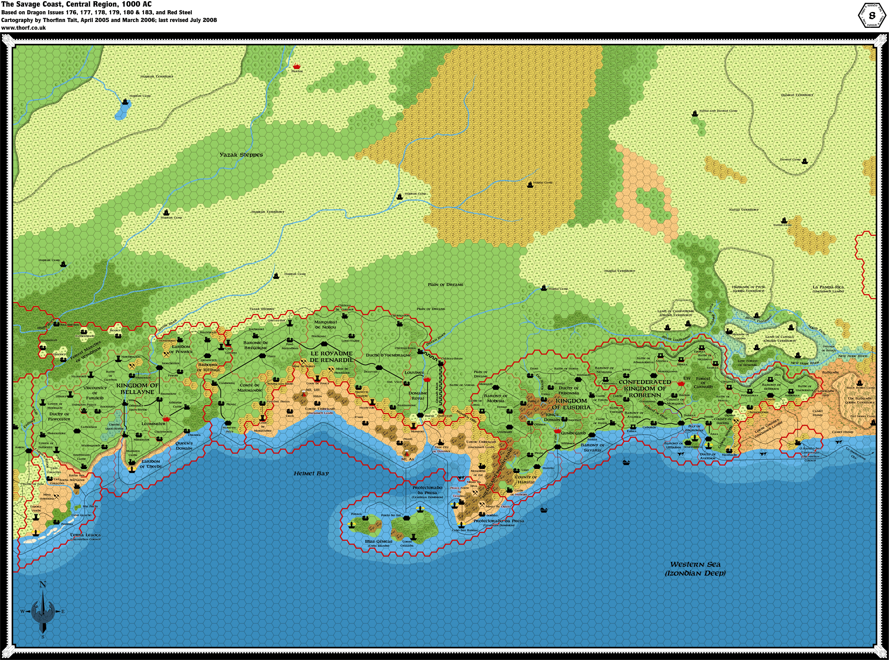 Jul 2008
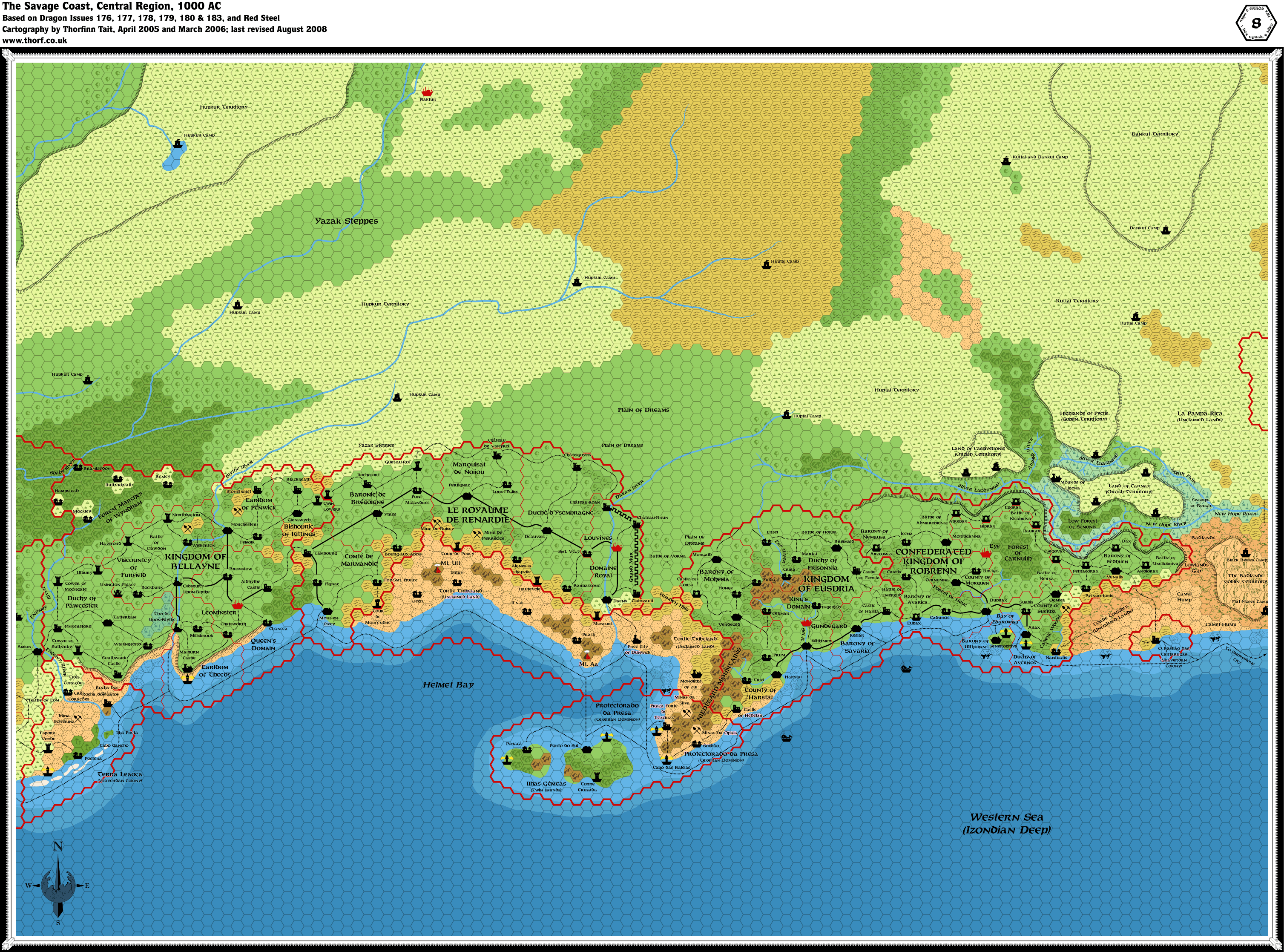 Aug 2008
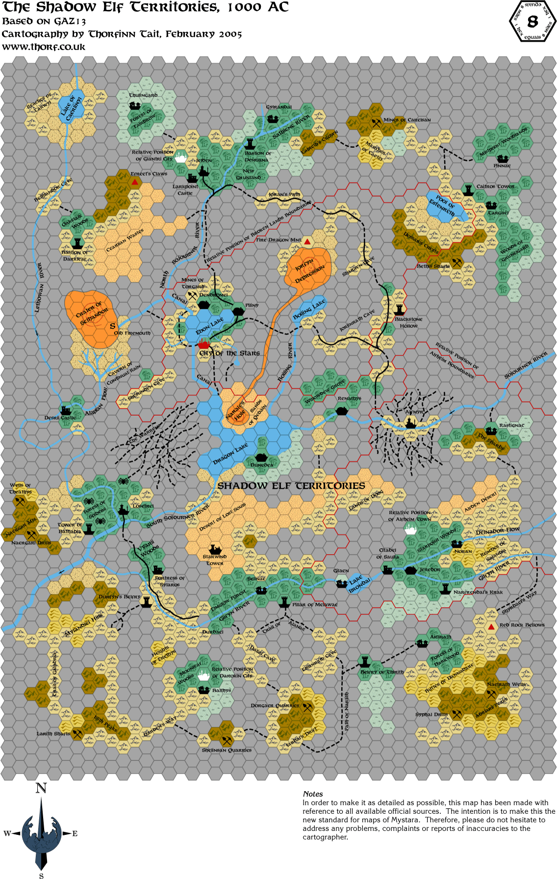 Mar 2005
 Mar 2005
 Apr 2006
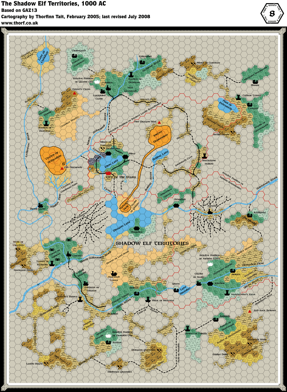 Jul 2008
 May 2009
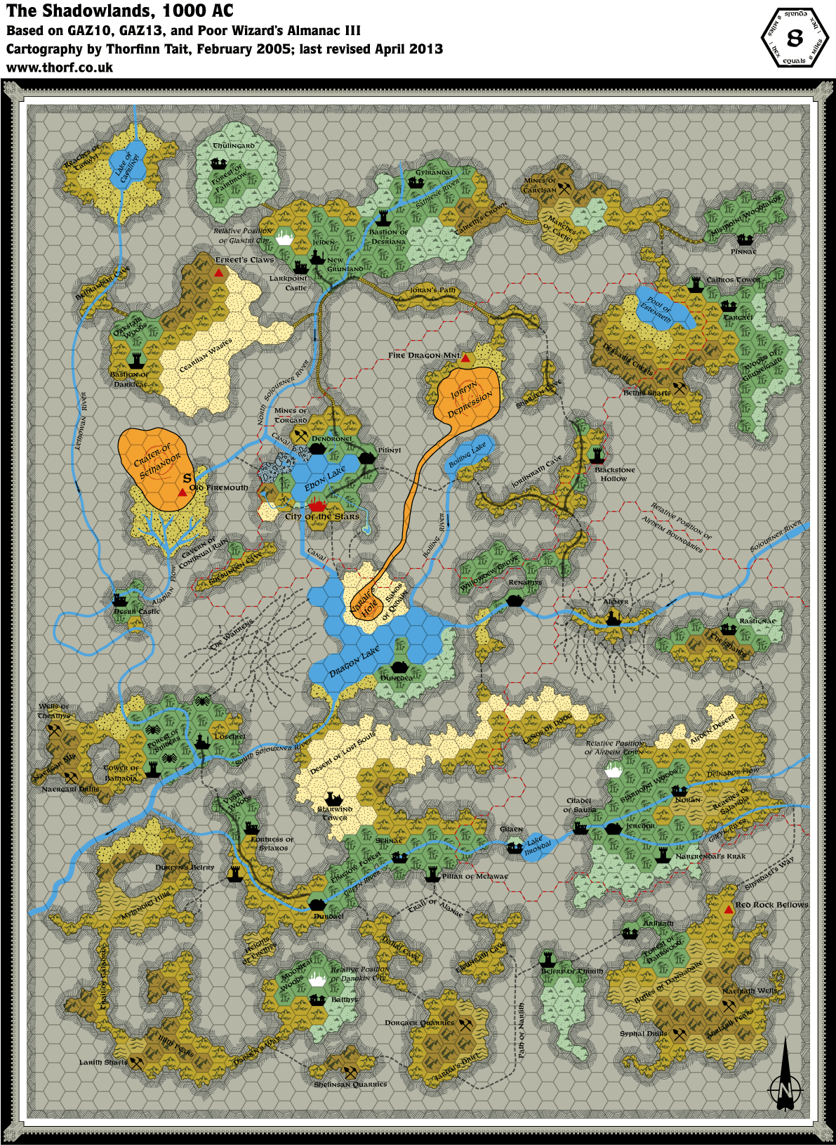 Apr 2013
 Feb 2016
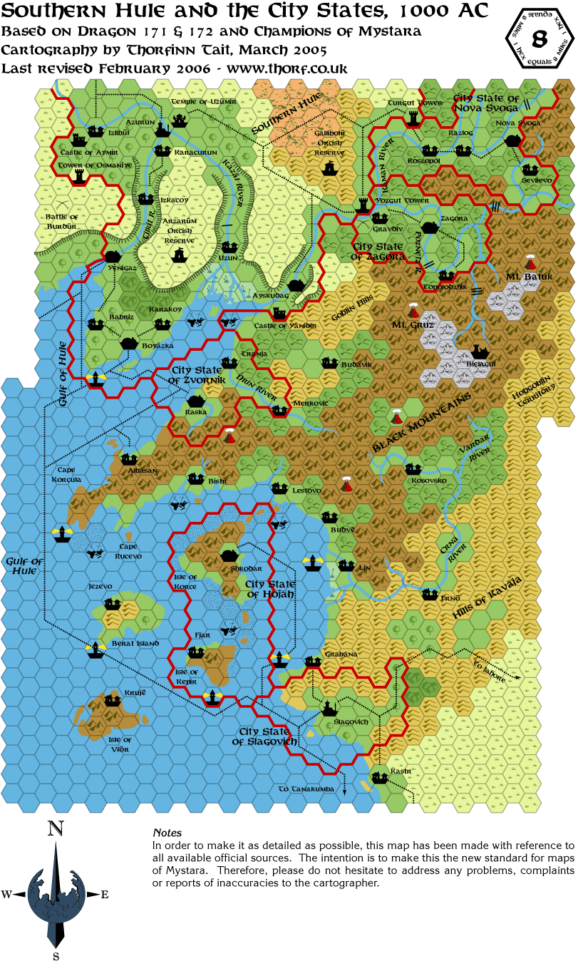 Feb 2006
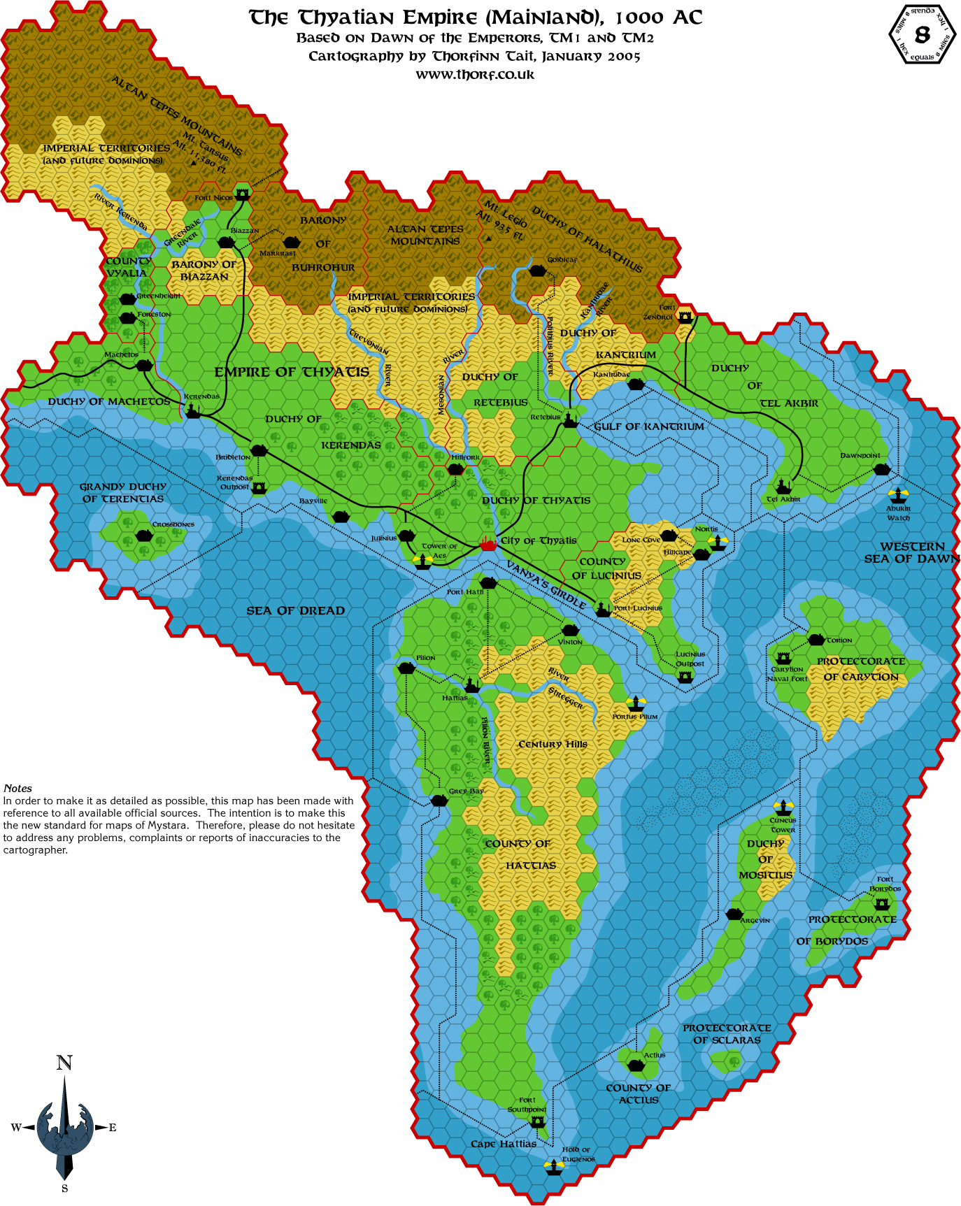 Mar 2005
 Jun 2005
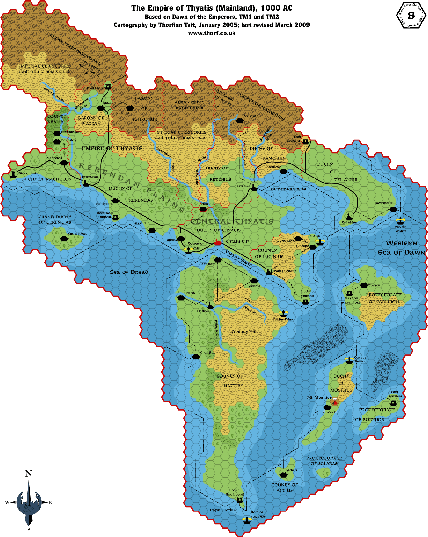 Mar 2009
 Jan 2016
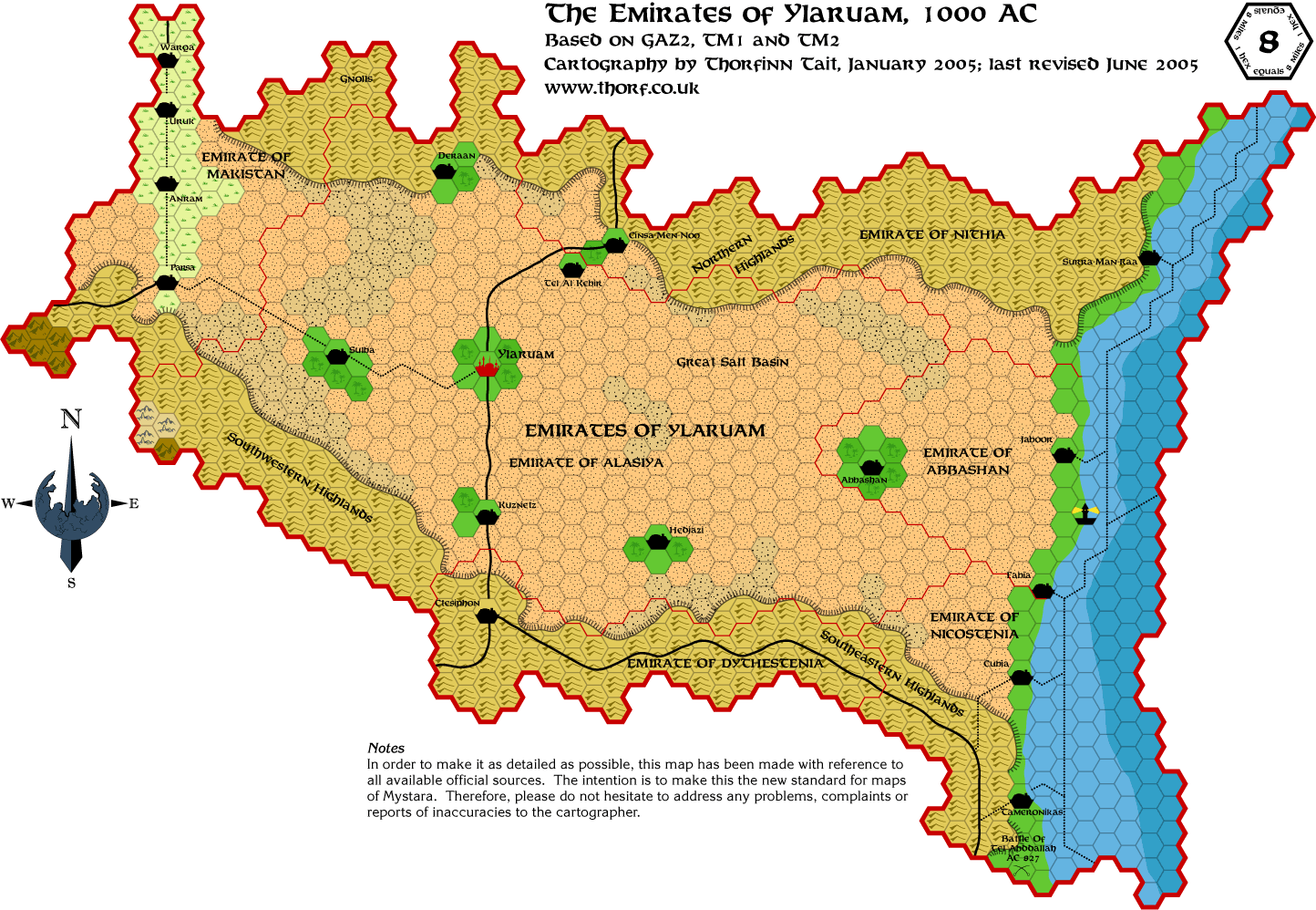 Jun 2005
 Aug 2008
 Mar 2009
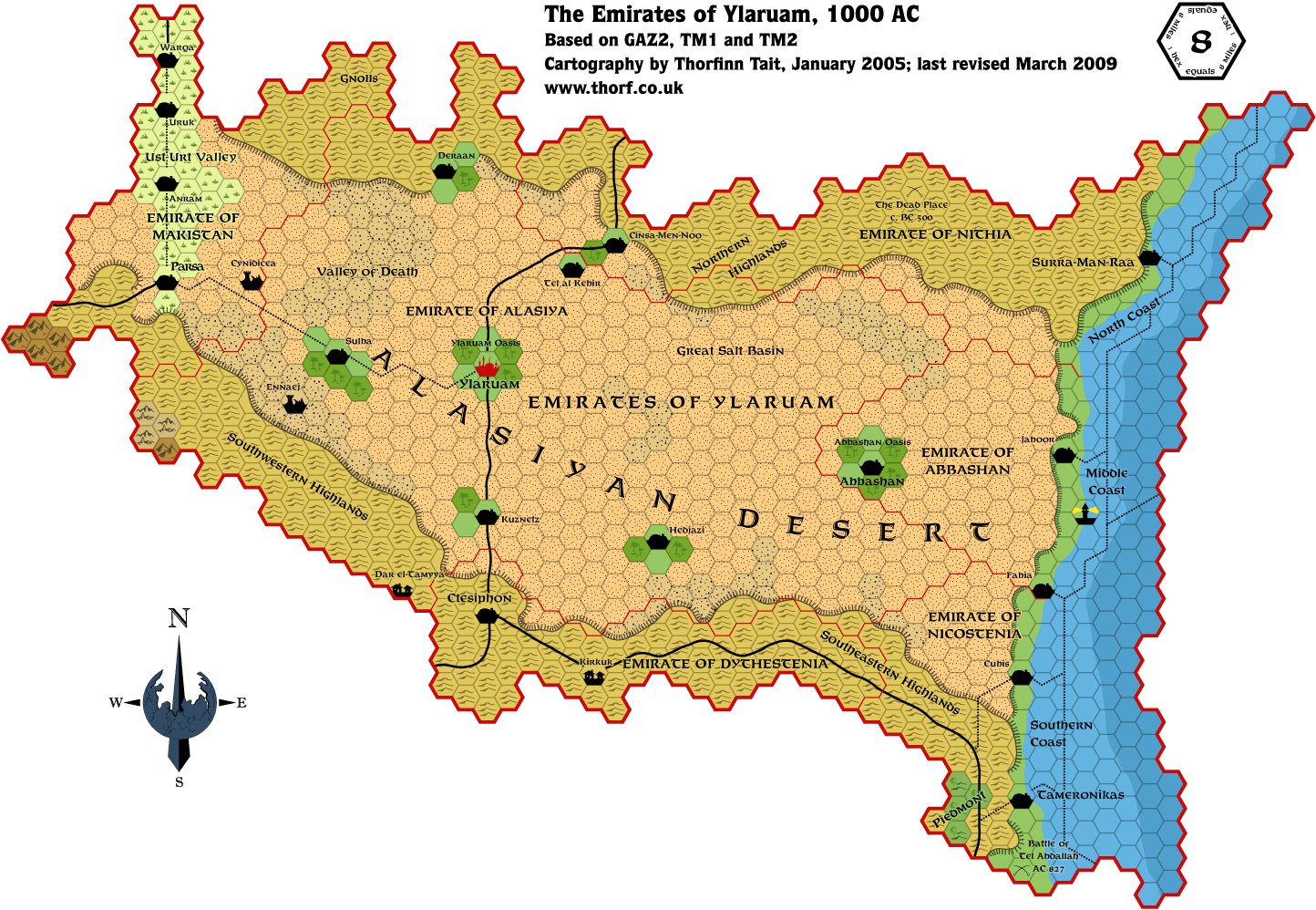 Mar 2009
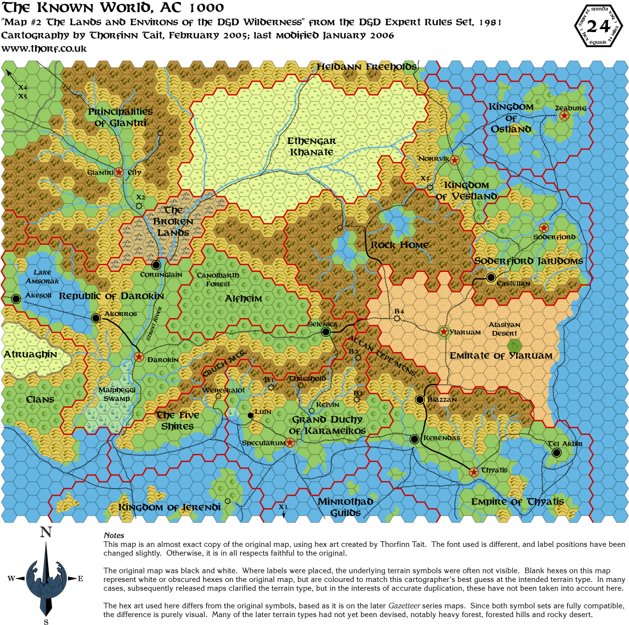 Jan 2006
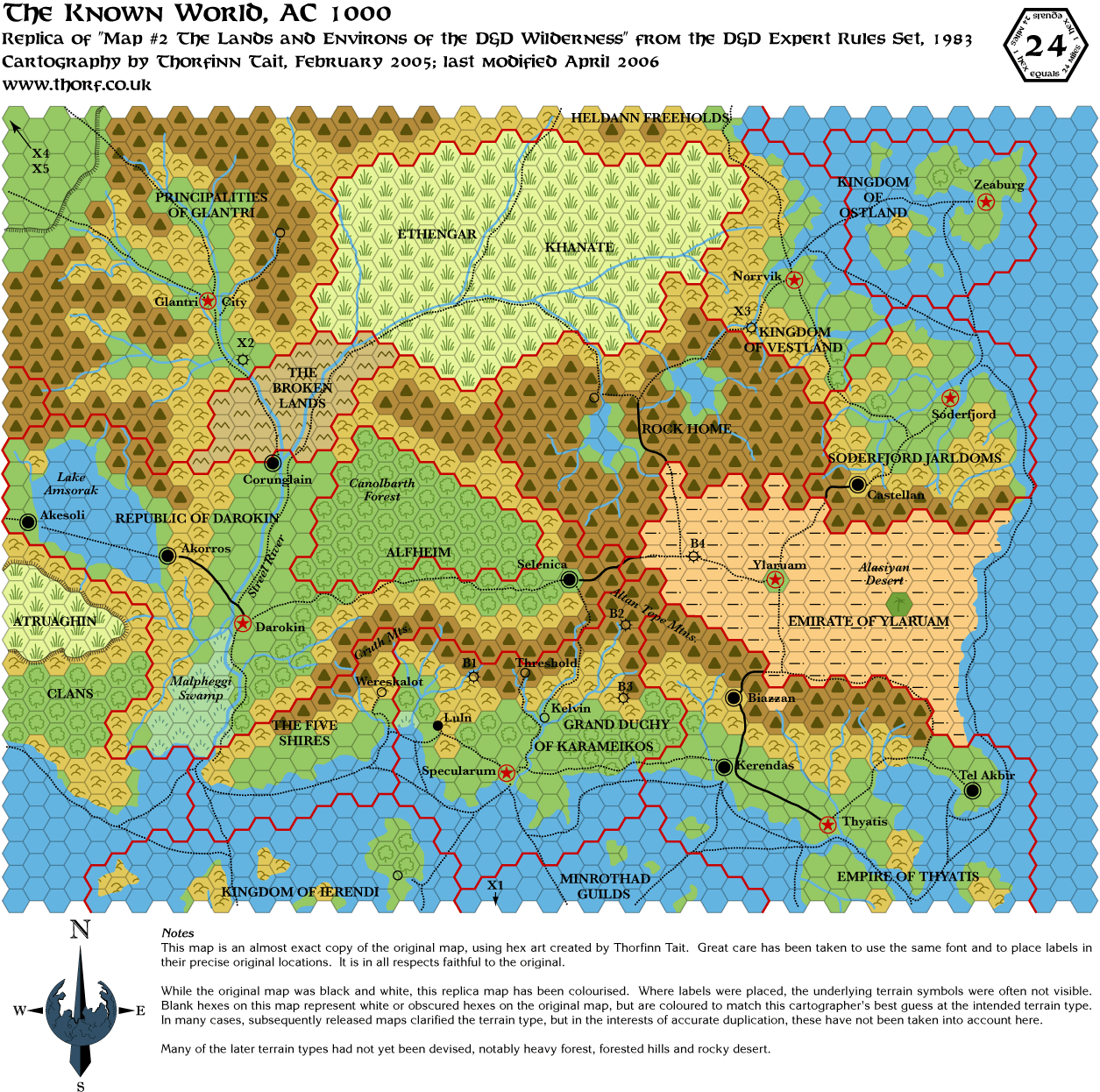 Apr 2006
 Jul 2008
 Feb 2013
 Apr 2018